
Land Subsidence on the Virginia Coastal Plain
Rising Tides, Sinking Coasts
Land subsidence makes coastal Virginia more vulnerable to flooding.
Monitoring is Key
USGS scientists are monitoring land subsidence across the Virginia Coastal Plain.
The Story of Subsidence
View our interactive narrative on Land Subsidence on the Virginia Coastal Plain
Featured Story:
In West Point, Virginia, a New 'Subsidence Superstation' Measures Changing Land Surface
Land subsidence is a loss of ground elevation, often experienced as the ground slowly sinking over the course of years. In eastern Virginia, high rates of groundwater use is a major factor in the land subsidence affecting the area.
The Virginia-West Virginia Water Science Center, with the help of our partners, has been monitoring land subsidence in the Virginia Coastal Plain since 1979 using a variety of tools and methods. This has included recording changes in land-surface elevation and groundwater levels, as well as expanding the Virginia extensometer network. This important long-term monitoring can help researchers more accurately predict the severity of future flooding, can help communities better understand the impacts of increased groundwater use and make sustainable decisions, and can help measure the effectiveness of groundwater restoration efforts.
Realtime Extensometer Data
Land subsidence is being monitored at extensometers installed in Virginia near Franklin, Suffolk, and Nansemond. Click the links below to access extensometer data at these sites:
Realtime Groundwater Data at Extensometer Sites
Groundwater levels are being monitored at each of the extensometer locations. Click the links below to access groundwater data at each site:
Realtime Groundwater Data at West Point Extensometer
Table of Contents
History of Aquifer-System Compaction in Eastern Virginia
Program Goals
The Land Subsidence Program aims to:
- Increase our understanding of how groundwater use affects both aquifer compaction and land subsidence on the Virginia Coastal Plain.
- Identify areas where subsidence may be increasing the hazards already posed by sea level rise.
- Measure the effectiveness of mitigation strategies that are designed to slow or reverse subsidence related to groundwater withdrawals, such as SWIFT.
- Provide our cooperators with the data they need to make sustainable groundwater management decisions.
Background
Land subsidence is caused by a combination of factors, both natural and anthropogenic. The Virginia Coastal Plain is particularly vulnerable to land subsidence. Factors like high rates of groundwater withdrawals, the resulting aquifer compaction, and post-glacial isostatic adjustment all contribute to the area's vulnerability. This in turn increases the Coastal Plain’s vulnerability to sea level rise. Therefore, it is important to understand exactly how much subsidence this area of Virginia is experiencing, and how that subsidence may vary across the study area.

History of Aquifer-System Compaction in Eastern Virginia
While the effects of subsidence are most obvious at the surface, the causes lie in the subsurface. To understand subsidence in the Virginia Coastal Plain, we must understand aquifer systems like the Potomac Aquifer System, the source of the majority of Eastern Virginia’s drinking water. Historically, groundwater was so abundant in the Potomac Aquifer System that it flowed freely from wells. This is because in confined aquifer systems like the Potomac, the groundwater is often under pressure. However, when groundwater is pumped from an aquifer or aquifer system for human use faster than it can recharge, groundwater levels and water pressure in the aquifer fall. Over time, if water levels do not recover, the aquifer compacts under the weight of the ground above, causing the land to subside as illustrated below.


When subsidence occurs near the coast, such as on the Virginia Coastal Plain, it compounds the effects of sea-level rise in response to climate change. The sinking ground causes relative sea level to rise faster, and potentially exacerbates its impacts. In fact, the highest rates of relative sea level rise along the entire Atlantic Coast are observed in Virginia, where land-subsidence rates, as measured by extensometers in Franklin, Suffolk, and Nansemond, are on the order of millimeters per year. This may seem small, but it impacts a large area where many people live, an area that is already prone to flooding and subject to the adverse effects of sea-level rise.
Though subsidence is a serious concern, there may be ways of slowing subsidence by restoring depleted aquifers in the Virginia Coastal Plain. The USGS has partnered with the Hampton Roads Sanitation District to monitor the effects of the ongoing Sustainable Water Initiative for Tomorrow, or SWIFT project. SWIFT seeks to reduce, and potentially reverse, land-subsidence in the region though introduction of highly treated wastewater back into the Potomac. However, SWIFT is not yet running at full-scale and groundwater withdrawals persist at high rates, so continued monitoring of land-surface deformation remains critical in coastal Virginia.
How is Subsidence Measured?
The USGS uses several different methods of measuring subsidence across the Virginia Coastal Plain. Each method has its own benefits and drawbacks, so using a variety of methods helps USGS scientists construct a complete picture of how the region is changing. Visit this page's data tab to access our measurement data.
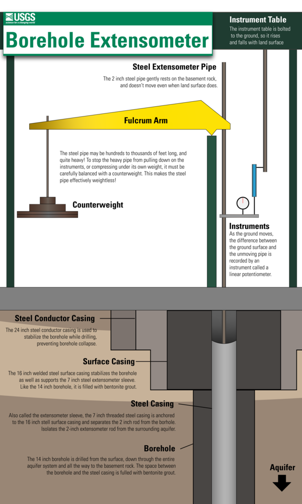
Borehole extensometers are instruments that directly measure the changes in aquifer-system thickness independent of other causes of vertical land motion that are affecting the Virginia Coastal Plain (such as forebulge collapse). These instruments provide a high-resolution (sub-millimeter), continuous record and are relatively simple in function. A borehole is drilled to the bottom of the aquifer system, down to the non-porous basement rock, which is where the extensometer pipe will ‘rest’ while extending to a predetermined height above the land surface. Once installation is complete, subsequent compaction of the aquifer system that produces subsidence will increase the length of pipe aboveground. Conversely, expansion of the aquifer system will produce uplift and decrease the length of pipe aboveground. Though borehole extensometers are incredibly precise, they only measure subsidence at a specific location and installing them is a significant undertaking, so they are often supplemented with more easily scalable methods of land subsidence monitoring. Click here for more in-depth information on our extensometer network.


Geodetic surveying is a method of recording the exact coordinates of a specific fixed location. When these surveys are repeated at the same location in an area affected by subsidence, scientists can determine how much the land surface has moved over time. During a survey, GPS equipment is placed on top of a special benchmark that has been permanently anchored into the ground to record whether the land has moved, and by how much. These surveys measure total land motion and cannot separate out what is caused by aquifer compaction and what is caused by other factors; however, this method can more easily measure subsidence over a wider area than extensometers alone. Geodetic surveys also play a critical role in validating InSAR data.

InSAR (interferometric synthetic aperture radar) is a satellite radar technique that can measure changes in land elevation over a large area. The maps generated by this technique, called interferograms, show how much the land surface elevation has changed between satellite passes. This technique can be used to monitor larger areas of the Virginia Coastal Plain than geodetic surveying and extensometers alone. However, InSAR data is less accurate than the other two methods, and cannot reliably measure subsidence of less than 5 millimeters, so it is most valuable when paired with geodetic and extensometer data. InSAR data is also useful for identifying subsidence 'hotspots' or areas of unexpected subsidence where future benchmarks or extensometers may need to be installed.
Virginia Extensometer Network
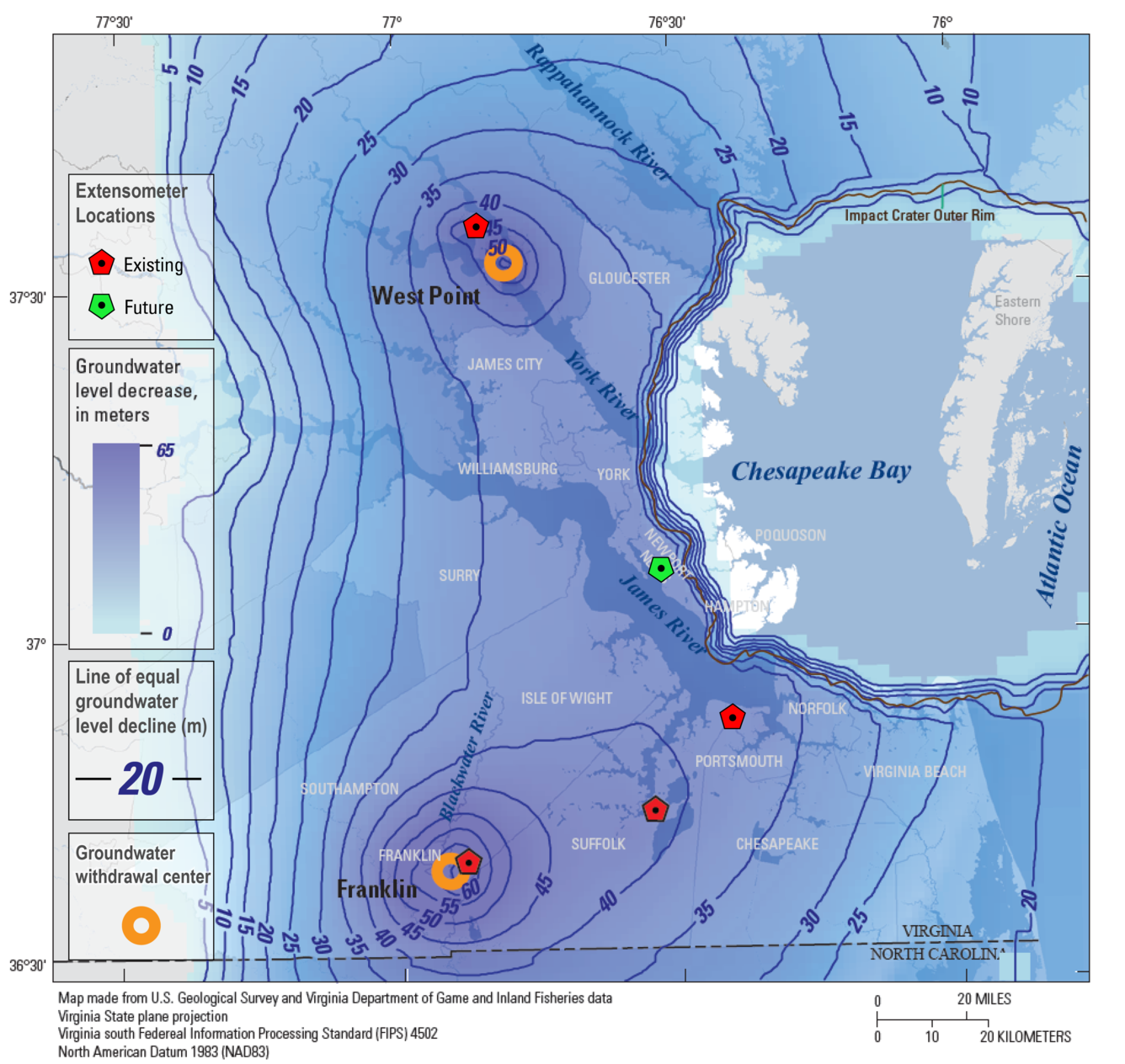
Currently, there are 4 active extensometers on the Virginia Coastal Plain. The above map shows the locations of the extensometers in the USGS' Virginia Extensometer Network.
Project Components
Click below to explore other aspects of our land subsidence research on the Virginia Coastal Plain.
Aquifer Compaction Monitoring
Geodetic Benchmark Monitoring - Hampton Roads Network
Geodetic Benchmark Monitoring - Chesapeake Bay Network
Groundwater-level Monitoring
Interactive Narrative - Land Subsidence in Virginia
Historical Perspectives - Coming Soon
Subsidence Infographics


Virginia Land Motion Photography
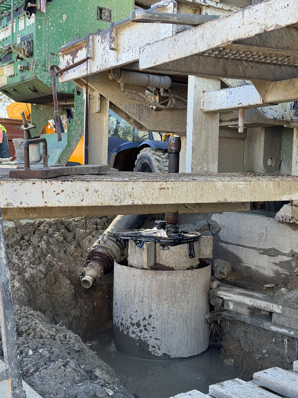
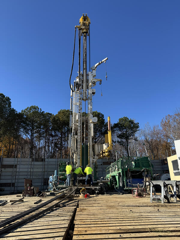
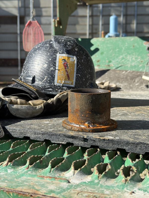
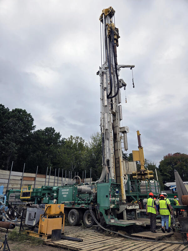
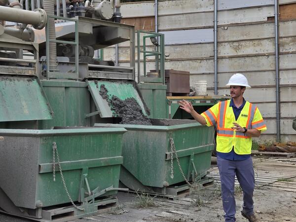
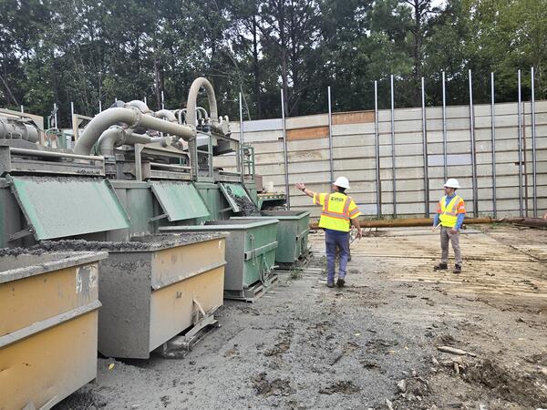


USGS Extensometer Drilling in Virginia
Along the Atlantic Coast, a 2000+ ft deep hole has been drilled by the USGS to assess the issues of groundwater pumping, relative sea-level rise, and land subsidence. This video shows the drilling of the first extensometer to measure land subsidence in the North Atlantic Coastal Plain in 30+ years. Land subsidence has been observed at various locations in the southern Chesapeake Bay region at...
Virginia Department of Environmental Quality
Many of the groundwater monitoring wells on the Virginia Coastal Plain as well as the extensometers at Franklin, Suffolk, and West Point are funded in part or entirely by the Virginia Department of Environmental Quality. Our important monitoring work would not be possible without their partnership.
The Chesapeake Bay Project

Scientists from the USGS are collaborating with the National Geodetic Survey, Virginia Tech, Maryland Geological Survey, Hampton University, The University of Maryland, The Virginia Institute of Marine Sciences, the Delaware Geological Survey, the Hampton Roads Planning District, and others to measure land-surface subsidence in the Chesapeake Bay region.
Hampton Roads Sanitation District

The USGS is partnering with the Hampton Roads Sanitation District (HRSD) to monitor the effects of their SWIFT program. Our Nansemond extensometer was generously funded by HRSD and is installed at HRSD's pilot aquifer injection site, where it can monitor for any changes in the rate of subsidence.
Land subsidence is a loss of ground elevation, often experienced as the ground slowly sinking over the course of years. In eastern Virginia, high rates of groundwater use is a major factor in the land subsidence affecting the area.
The Virginia-West Virginia Water Science Center, with the help of our partners, has been monitoring land subsidence in the Virginia Coastal Plain since 1979 using a variety of tools and methods. This has included recording changes in land-surface elevation and groundwater levels, as well as expanding the Virginia extensometer network. This important long-term monitoring can help researchers more accurately predict the severity of future flooding, can help communities better understand the impacts of increased groundwater use and make sustainable decisions, and can help measure the effectiveness of groundwater restoration efforts.
Realtime Extensometer Data
Land subsidence is being monitored at extensometers installed in Virginia near Franklin, Suffolk, and Nansemond. Click the links below to access extensometer data at these sites:
Realtime Groundwater Data at Extensometer Sites
Groundwater levels are being monitored at each of the extensometer locations. Click the links below to access groundwater data at each site:
Realtime Groundwater Data at West Point Extensometer
Table of Contents
History of Aquifer-System Compaction in Eastern Virginia
Program Goals
The Land Subsidence Program aims to:
- Increase our understanding of how groundwater use affects both aquifer compaction and land subsidence on the Virginia Coastal Plain.
- Identify areas where subsidence may be increasing the hazards already posed by sea level rise.
- Measure the effectiveness of mitigation strategies that are designed to slow or reverse subsidence related to groundwater withdrawals, such as SWIFT.
- Provide our cooperators with the data they need to make sustainable groundwater management decisions.
Background
Land subsidence is caused by a combination of factors, both natural and anthropogenic. The Virginia Coastal Plain is particularly vulnerable to land subsidence. Factors like high rates of groundwater withdrawals, the resulting aquifer compaction, and post-glacial isostatic adjustment all contribute to the area's vulnerability. This in turn increases the Coastal Plain’s vulnerability to sea level rise. Therefore, it is important to understand exactly how much subsidence this area of Virginia is experiencing, and how that subsidence may vary across the study area.
History of Aquifer-System Compaction in Eastern Virginia
While the effects of subsidence are most obvious at the surface, the causes lie in the subsurface. To understand subsidence in the Virginia Coastal Plain, we must understand aquifer systems like the Potomac Aquifer System, the source of the majority of Eastern Virginia’s drinking water. Historically, groundwater was so abundant in the Potomac Aquifer System that it flowed freely from wells. This is because in confined aquifer systems like the Potomac, the groundwater is often under pressure. However, when groundwater is pumped from an aquifer or aquifer system for human use faster than it can recharge, groundwater levels and water pressure in the aquifer fall. Over time, if water levels do not recover, the aquifer compacts under the weight of the ground above, causing the land to subside as illustrated below.
When subsidence occurs near the coast, such as on the Virginia Coastal Plain, it compounds the effects of sea-level rise in response to climate change. The sinking ground causes relative sea level to rise faster, and potentially exacerbates its impacts. In fact, the highest rates of relative sea level rise along the entire Atlantic Coast are observed in Virginia, where land-subsidence rates, as measured by extensometers in Franklin, Suffolk, and Nansemond, are on the order of millimeters per year. This may seem small, but it impacts a large area where many people live, an area that is already prone to flooding and subject to the adverse effects of sea-level rise.
Though subsidence is a serious concern, there may be ways of slowing subsidence by restoring depleted aquifers in the Virginia Coastal Plain. The USGS has partnered with the Hampton Roads Sanitation District to monitor the effects of the ongoing Sustainable Water Initiative for Tomorrow, or SWIFT project. SWIFT seeks to reduce, and potentially reverse, land-subsidence in the region though introduction of highly treated wastewater back into the Potomac. However, SWIFT is not yet running at full-scale and groundwater withdrawals persist at high rates, so continued monitoring of land-surface deformation remains critical in coastal Virginia.
How is Subsidence Measured?
The USGS uses several different methods of measuring subsidence across the Virginia Coastal Plain. Each method has its own benefits and drawbacks, so using a variety of methods helps USGS scientists construct a complete picture of how the region is changing. Visit this page's data tab to access our measurement data.
Borehole extensometers are instruments that directly measure the changes in aquifer-system thickness independent of other causes of vertical land motion that are affecting the Virginia Coastal Plain (such as forebulge collapse). These instruments provide a high-resolution (sub-millimeter), continuous record and are relatively simple in function. A borehole is drilled to the bottom of the aquifer system, down to the non-porous basement rock, which is where the extensometer pipe will ‘rest’ while extending to a predetermined height above the land surface. Once installation is complete, subsequent compaction of the aquifer system that produces subsidence will increase the length of pipe aboveground. Conversely, expansion of the aquifer system will produce uplift and decrease the length of pipe aboveground. Though borehole extensometers are incredibly precise, they only measure subsidence at a specific location and installing them is a significant undertaking, so they are often supplemented with more easily scalable methods of land subsidence monitoring. Click here for more in-depth information on our extensometer network.
Geodetic surveying is a method of recording the exact coordinates of a specific fixed location. When these surveys are repeated at the same location in an area affected by subsidence, scientists can determine how much the land surface has moved over time. During a survey, GPS equipment is placed on top of a special benchmark that has been permanently anchored into the ground to record whether the land has moved, and by how much. These surveys measure total land motion and cannot separate out what is caused by aquifer compaction and what is caused by other factors; however, this method can more easily measure subsidence over a wider area than extensometers alone. Geodetic surveys also play a critical role in validating InSAR data.
InSAR (interferometric synthetic aperture radar) is a satellite radar technique that can measure changes in land elevation over a large area. The maps generated by this technique, called interferograms, show how much the land surface elevation has changed between satellite passes. This technique can be used to monitor larger areas of the Virginia Coastal Plain than geodetic surveying and extensometers alone. However, InSAR data is less accurate than the other two methods, and cannot reliably measure subsidence of less than 5 millimeters, so it is most valuable when paired with geodetic and extensometer data. InSAR data is also useful for identifying subsidence 'hotspots' or areas of unexpected subsidence where future benchmarks or extensometers may need to be installed.
Virginia Extensometer Network
Currently, there are 4 active extensometers on the Virginia Coastal Plain. The above map shows the locations of the extensometers in the USGS' Virginia Extensometer Network.
Project Components
Click below to explore other aspects of our land subsidence research on the Virginia Coastal Plain.
Aquifer Compaction Monitoring
Geodetic Benchmark Monitoring - Hampton Roads Network
Geodetic Benchmark Monitoring - Chesapeake Bay Network
Groundwater-level Monitoring
Interactive Narrative - Land Subsidence in Virginia
Historical Perspectives - Coming Soon
Subsidence Infographics
Virginia Land Motion Photography
USGS Extensometer Drilling in Virginia
Along the Atlantic Coast, a 2000+ ft deep hole has been drilled by the USGS to assess the issues of groundwater pumping, relative sea-level rise, and land subsidence. This video shows the drilling of the first extensometer to measure land subsidence in the North Atlantic Coastal Plain in 30+ years. Land subsidence has been observed at various locations in the southern Chesapeake Bay region at...
Virginia Department of Environmental Quality
Many of the groundwater monitoring wells on the Virginia Coastal Plain as well as the extensometers at Franklin, Suffolk, and West Point are funded in part or entirely by the Virginia Department of Environmental Quality. Our important monitoring work would not be possible without their partnership.
The Chesapeake Bay Project
Scientists from the USGS are collaborating with the National Geodetic Survey, Virginia Tech, Maryland Geological Survey, Hampton University, The University of Maryland, The Virginia Institute of Marine Sciences, the Delaware Geological Survey, the Hampton Roads Planning District, and others to measure land-surface subsidence in the Chesapeake Bay region.
Hampton Roads Sanitation District
The USGS is partnering with the Hampton Roads Sanitation District (HRSD) to monitor the effects of their SWIFT program. Our Nansemond extensometer was generously funded by HRSD and is installed at HRSD's pilot aquifer injection site, where it can monitor for any changes in the rate of subsidence.