


The LANDFIRE (LF) program is working to increase the frequency of product releases and to reduce the latency of the LF products by producing annual version releases that reflect data less than one year behind current conditions and represent data conditions homologous to the growth that one would expect in areas of change/disturbances up to the year when the product
LANDFIRE-Landscape Fire and Resource Management Planning Tools
Active
By Earth Resources Observation and Science (EROS) Center
September 10, 2018
LANDFIRE Publications and Resources
LANDFIRE (LF), a shared program between the wildland fire management programs of the U.S. Department of Agriculture (USDA) Forest Service (FS) and the U.S. Department of the Interior (DOI), represents the first and only complete nationally consistent collection of more than 26 geospatial layers (e.g. vegetation, fuel, disturbance, etc.), databases, and ecological models.
LANDFIRE Map Viewer
LANDFIRE Map Viewer

The interactive viewer offers a simplified interface, streamlined downloads, and improvements in data layer visualization.
LF marks 20 years
LF marks 20 years

Learn how LANDFIRE is making its valuable fire-related data even better in this episode of our remote sensing podcast.
Links of Interest
Links of Interest
Below are other science projects associated with this project.

Eyes on Earth Episode 102 – LANDFIRE 2022 Update
LANDFIRE, a trusted source for fire-related data, has started releasing key information even faster.
Eyes on Earth Episode 125 – The LANDFIRE Program at 20
LANDFIRE is a diverse product suite with countless uses that go beyond fire management. The program has now been providing this satellite data for 20 years.
Eyes on Earth Episode 102 – LANDFIRE 2022 Update
LANDFIRE, a trusted source for fire-related data, has started releasing key information even faster.

Eyes on Earth Episode 56 – Modeling the Past to Plan for the Future Eyes on Earth Episode 56 – Modeling the Past to Plan for the Future
Eyes on Earth is a podcast on remote sensing, Earth observation, land change and science, brought to you by the USGS Earth Resources Observation and Science (EROS) Center. In this episode, we learn how scientists built a map of pre-Colonial land cover in the U.S.

Eyes on Earth Episode 51 – LANDFIRE 2019 Limited Eyes on Earth Episode 51 – LANDFIRE 2019 Limited
Eyes on Earth is a podcast on remote sensing, Earth observation, land change and science, brought to you by the USGS Earth Resources Observation and Science (EROS) Center. In this episode, we learn about a new update to LANDFIRE mapping products.

Eyes on Earth Episode 48 – Satellites and the Forest Census Eyes on Earth Episode 48 – Satellites and the Forest Census
Eyes on Earth is a podcast on remote sensing, Earth observation, land change and science, brought to you by the USGS Earth Resources Observation and Science (EROS) Center. In this episode, we hear how the Nation’s forest census aids satellite-based mapping efforts.

Eyes on Earth Episode 30 – Remapping LANDFIRE Eyes on Earth Episode 30 – Remapping LANDFIRE
Eyes on Earth is a podcast on remote sensing, Earth observation, land change and science, brought to you by the USGS Earth Resources Observation and Science (EROS) Center. In this episode, we learn about LANDFIRE and a yearslong project to improve the critical nationwide data source.

Eyes on Earth Episode 24 – Wildfire Risk to Communities Eyes on Earth Episode 24 – Wildfire Risk to Communities
Eyes on Earth is a podcast on remote sensing, Earth observation, land change and science, brought to you by the USGS Earth Resources Observation and Science (EROS) Center. In this episode, we hear about a national wildfire risk tool built using satellite-derived mapping data produced at EROS.

LANDFIRE-Landscape Fire and Resource Management Planning Tools
LANDFIRE (LF), a shared program between the wildland fire management programs of the U.S. Department of Agriculture (USDA) Forest Service (FS) and the U.S. Department of the Interior (DOI), represents the first and only complete nationally consistent collection of more than 26 geospatial layers (e.g. vegetation, fuel, disturbance, etc.), databases, and ecological models.

Monitoring Trends in Burn Severity
Monitoring Trends in Burn Severity (MTBS) is an interagency program whose goal is to consistently map the burn severity and extent of large fires across all lands of the United States from 1984 to present. This includes all fires 1,000 acres or greater in the western United States and 500 acres or greater in the eastern Unites States. The extent of coverage includes the continental U.S., Alaska...
Below are multimedia items associated with this project.

LANDFIRE 2019 Limited Update
The LANDFIRE (LF) program is working to increase the frequency of product releases and to reduce the latency of the LF products by producing annual version releases that reflect data less than one year behind current conditions and represent data conditions homologous to the growth that one would expect in areas of change/disturbances up to the year when the product

LANDFIRE Remap 2020
LANDFIRE (LF) Remap is the most comprehensive mapping effort in LF's history. This years-long effort included updating the base maps across the original data product suite to create LF's second base map product suite consisting of 28 vegetation and fuels layers. LF Remap products reflect circa 2016 ground conditions.
LANDFIRE (LF) Remap is the most comprehensive mapping effort in LF's history. This years-long effort included updating the base maps across the original data product suite to create LF's second base map product suite consisting of 28 vegetation and fuels layers. LF Remap products reflect circa 2016 ground conditions.

LANDFIRE- Landscape Fire and Resource Management Planning Tools
LANDFIRE- Landscape Fire and Resource Management Planning ToolsLANDFIRE Existing Vegetation Type imagery.
LANDFIRE- Landscape Fire and Resource Management Planning Tools
LANDFIRE- Landscape Fire and Resource Management Planning ToolsLANDFIRE Existing Vegetation Type imagery.

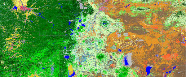
LANDFIRE Existing Vegetation Type
LANDFIRE's Existing Vegetation Type layer from the Data Distribution Site.
LANDFIRE's Existing Vegetation Type layer from the Data Distribution Site.
Below are news stories associated with this project.

LANDFIRE Quickens Pace for Providing Key Fire Data LANDFIRE Quickens Pace for Providing Key Fire Data
In 2024, LANDFIRE (Landscape Fire and Resource Management Planning Tools) marks 20 years since it was officially chartered in response to increasing concern about the number, severity and size of wildland fires in the United States.
LANDFIRE (LF), a shared program between the wildland fire management programs of the U.S. Department of Agriculture (USDA) Forest Service (FS) and the U.S. Department of the Interior (DOI), represents the first and only complete nationally consistent collection of more than 26 geospatial layers (e.g. vegetation, fuel, disturbance, etc.), databases, and ecological models.
LANDFIRE Map Viewer
LANDFIRE Map Viewer
The interactive viewer offers a simplified interface, streamlined downloads, and improvements in data layer visualization.
LF marks 20 years
LF marks 20 years
Learn how LANDFIRE is making its valuable fire-related data even better in this episode of our remote sensing podcast.
Links of Interest
Links of Interest
Below are other science projects associated with this project.
Eyes on Earth Episode 102 – LANDFIRE 2022 Update
LANDFIRE, a trusted source for fire-related data, has started releasing key information even faster.
Eyes on Earth Episode 125 – The LANDFIRE Program at 20
LANDFIRE is a diverse product suite with countless uses that go beyond fire management. The program has now been providing this satellite data for 20 years.
Eyes on Earth Episode 102 – LANDFIRE 2022 Update
LANDFIRE, a trusted source for fire-related data, has started releasing key information even faster.
Eyes on Earth Episode 56 – Modeling the Past to Plan for the Future Eyes on Earth Episode 56 – Modeling the Past to Plan for the Future
Eyes on Earth is a podcast on remote sensing, Earth observation, land change and science, brought to you by the USGS Earth Resources Observation and Science (EROS) Center. In this episode, we learn how scientists built a map of pre-Colonial land cover in the U.S.
Eyes on Earth Episode 51 – LANDFIRE 2019 Limited Eyes on Earth Episode 51 – LANDFIRE 2019 Limited
Eyes on Earth is a podcast on remote sensing, Earth observation, land change and science, brought to you by the USGS Earth Resources Observation and Science (EROS) Center. In this episode, we learn about a new update to LANDFIRE mapping products.
Eyes on Earth Episode 48 – Satellites and the Forest Census Eyes on Earth Episode 48 – Satellites and the Forest Census
Eyes on Earth is a podcast on remote sensing, Earth observation, land change and science, brought to you by the USGS Earth Resources Observation and Science (EROS) Center. In this episode, we hear how the Nation’s forest census aids satellite-based mapping efforts.
Eyes on Earth Episode 30 – Remapping LANDFIRE Eyes on Earth Episode 30 – Remapping LANDFIRE
Eyes on Earth is a podcast on remote sensing, Earth observation, land change and science, brought to you by the USGS Earth Resources Observation and Science (EROS) Center. In this episode, we learn about LANDFIRE and a yearslong project to improve the critical nationwide data source.
Eyes on Earth Episode 24 – Wildfire Risk to Communities Eyes on Earth Episode 24 – Wildfire Risk to Communities
Eyes on Earth is a podcast on remote sensing, Earth observation, land change and science, brought to you by the USGS Earth Resources Observation and Science (EROS) Center. In this episode, we hear about a national wildfire risk tool built using satellite-derived mapping data produced at EROS.
LANDFIRE-Landscape Fire and Resource Management Planning Tools
LANDFIRE (LF), a shared program between the wildland fire management programs of the U.S. Department of Agriculture (USDA) Forest Service (FS) and the U.S. Department of the Interior (DOI), represents the first and only complete nationally consistent collection of more than 26 geospatial layers (e.g. vegetation, fuel, disturbance, etc.), databases, and ecological models.
Monitoring Trends in Burn Severity
Monitoring Trends in Burn Severity (MTBS) is an interagency program whose goal is to consistently map the burn severity and extent of large fires across all lands of the United States from 1984 to present. This includes all fires 1,000 acres or greater in the western United States and 500 acres or greater in the eastern Unites States. The extent of coverage includes the continental U.S., Alaska...
Below are multimedia items associated with this project.
LANDFIRE 2019 Limited Update
The LANDFIRE (LF) program is working to increase the frequency of product releases and to reduce the latency of the LF products by producing annual version releases that reflect data less than one year behind current conditions and represent data conditions homologous to the growth that one would expect in areas of change/disturbances up to the year when the product
The LANDFIRE (LF) program is working to increase the frequency of product releases and to reduce the latency of the LF products by producing annual version releases that reflect data less than one year behind current conditions and represent data conditions homologous to the growth that one would expect in areas of change/disturbances up to the year when the product
LANDFIRE Remap 2020
LANDFIRE (LF) Remap is the most comprehensive mapping effort in LF's history. This years-long effort included updating the base maps across the original data product suite to create LF's second base map product suite consisting of 28 vegetation and fuels layers. LF Remap products reflect circa 2016 ground conditions.
LANDFIRE (LF) Remap is the most comprehensive mapping effort in LF's history. This years-long effort included updating the base maps across the original data product suite to create LF's second base map product suite consisting of 28 vegetation and fuels layers. LF Remap products reflect circa 2016 ground conditions.
LANDFIRE- Landscape Fire and Resource Management Planning Tools
LANDFIRE- Landscape Fire and Resource Management Planning ToolsLANDFIRE Existing Vegetation Type imagery.
LANDFIRE- Landscape Fire and Resource Management Planning Tools
LANDFIRE- Landscape Fire and Resource Management Planning ToolsLANDFIRE Existing Vegetation Type imagery.
LANDFIRE Existing Vegetation Type
LANDFIRE's Existing Vegetation Type layer from the Data Distribution Site.
LANDFIRE's Existing Vegetation Type layer from the Data Distribution Site.
Below are news stories associated with this project.
LANDFIRE Quickens Pace for Providing Key Fire Data LANDFIRE Quickens Pace for Providing Key Fire Data
In 2024, LANDFIRE (Landscape Fire and Resource Management Planning Tools) marks 20 years since it was officially chartered in response to increasing concern about the number, severity and size of wildland fires in the United States.