U.S. flag

An official website of the United States government

Images

Energy and Minerals Mission Area images.

Filter Total Items: 538
Geologic map in varying shades of pink, orange and yellow depicting different rock units in the Bear Camp Gulch Quadrangle; text at the bottom of map and index map for location within the state of Idaho.
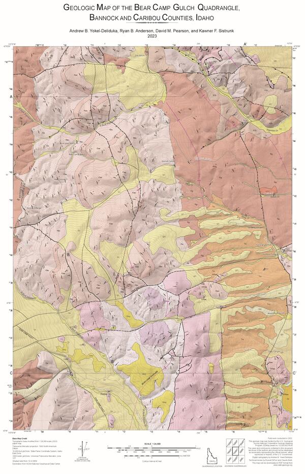
EDMAP Geologic Map of the Bear Camp Gulch Quadrangle, Bannock and Caribou Counties, Idaho

The Geologic Map of the Bear Camp Gulch Quadrangle started out as an EDMAP project at Idaho State University. EDMAP student Andrew Yokel-Deliduka worked with the Idaho Geological Survey to publish the map and presented it at GSA Connects 2024 to win the Best Student Geologic Map Competition. The image used here is an excerpt from the original product. 

The Geologic Map of the Bear Camp Gulch Quadrangle started out as an EDMAP project at Idaho State University. EDMAP student Andrew Yokel-Deliduka worked with the Idaho Geological Survey to publish the map and presented it at GSA Connects 2024 to win the Best Student Geologic Map Competition. The image used here is an excerpt from the original product. 

Saucer Shark on landing approach to landing pad. Aeroshell shown to be flying over California Hills.
Flying Saucer Shark Deployed over the skies of California

USGS National Innovation Center UAS Research Center Saucer Shark Project, during flight tests, aeroshell. Saucer Shark on landing approach after completed mission. Just above the landing pad.

USGS National Innovation Center UAS Research Center Saucer Shark Project, during flight tests, aeroshell. Saucer Shark on landing approach after completed mission. Just above the landing pad.

National Innovation Center UAS Research Center Saucer Shark drop lease sits on landing pad  in remote California.
Saucer Shark Drop Release during testing campaign

USGS National Innovation Center UAS Research Center Saucer Shark Project, during flight tests, drop release attached to USGS UAV. Aircraft sits on landing pad in-between test flights.

USGS National Innovation Center UASRC Saucer Shark fully assembled and deployed below UAV ​
Saucer Shark Deployed Below UAV​

USGS National Innovation Center UAS Research Center (UASRC) Saucer Shark Project, during flight tests, fully assembled. Sub assemblies from top down: Drop Release, Sling and Sling Brace, Payload Aeroshell and Payload.​

USGS National Innovation Center UAS Research Center (UASRC) Saucer Shark Project, during flight tests, fully assembled. Sub assemblies from top down: Drop Release, Sling and Sling Brace, Payload Aeroshell and Payload.​

Children reaching for samples of rocks and minerals during outreach event
Children looking at rocks and minerals during educational outreach event

Nāʻālehu Elementary School keiki explore different properties of rocks and minerals at the grand opening of the Honuworks Robotic Center. UH Hilo photo by Meghann Decker.

Image shows a map of the United States, including Alaska, Puerto Rico and Hawaii, with locations of mineral systems marked
Mineral Systems Map of the United States

Maps showing parts of 23 mineral systems that could host critical mineral resources in the United States.  These areas are used to prioritize data collection and analysis by Earth MRI.

Image shows a mountain landscape with trees and snow-covered peaks
Montana
Montana
Montana

A view of the Boulder Mountains from US-12 west of Helena. These mountains lie at the north end of the Boulder Batholith.

A view of the Boulder Mountains from US-12 west of Helena. These mountains lie at the north end of the Boulder Batholith.

logo for the Space Economy Workshop Series
Space Economy Workshop Series

NASA and the United States Geological Survey (USGS) welcome the community to a series of Space Economy Workshops intended to coordinate the development of new technologies to detect and assess off-world mineral resources, as well as to discuss the challenges and opportunities for an off-world mineral resource economy. 

NASA and the United States Geological Survey (USGS) welcome the community to a series of Space Economy Workshops intended to coordinate the development of new technologies to detect and assess off-world mineral resources, as well as to discuss the challenges and opportunities for an off-world mineral resource economy. 

Image shows a small aircraft at an airport with a stinger tail on it for the airborne geophysical data collection
Aircraft with Geophysical Survey Equipment

A typical survey airplane. The magnetic sensor is placed in an extension on the back of the airplane to reduce the impact of the airplane’s own magnetic field. 

Reston stable isotope lab (RSIL): Delta V Plus Isotope Ratio Mass Spectrometer and peripherals
Reston stable isotope lab (RSIL): Delta V Plus Isotope Ratio Mass Spectrometer and peripherals at the Reston Stable Isotope Laboratory
Illinois River Basin low-level flight map overview
Illinois River Basin low-level flight overview

This map shows the airborne geophysical survey area and planned flight paths across the Illinois River Basin in Illinois and northwest Indiana. Surveys will not occur directly above populated areas. Planned flight lines and survey progress can be found online

(USGS map) 

This map shows the airborne geophysical survey area and planned flight paths across the Illinois River Basin in Illinois and northwest Indiana. Surveys will not occur directly above populated areas. Planned flight lines and survey progress can be found online

(USGS map) 

Image shows a detailed view of a rock with the tip of a pencil for scale
Pennington Mountain Rock with Critical Minerals

A fine-grained volcanic rock (trachyte) that hosts rare earth elements, niobium, and zirconium, all which are considered critical mineral resources. This rock was found on Pennington Mountain in Maine. Image courtesy of Chunzeng Wang, University of Maine-Presque Isle.

A fine-grained volcanic rock (trachyte) that hosts rare earth elements, niobium, and zirconium, all which are considered critical mineral resources. This rock was found on Pennington Mountain in Maine. Image courtesy of Chunzeng Wang, University of Maine-Presque Isle.

Montana Low-level Flight Survey Area
MTLLFareamap.JPG
MTLLFareamap.JPG
MTLLFareamap.JPG

Survey area for low-flying helicopter soon to be visible in six Montana counties, including Helena, the Elkhorn Mountains, Bull Mountain and the Tobacco Root Mountains.

Survey area for low-flying helicopter soon to be visible in six Montana counties, including Helena, the Elkhorn Mountains, Bull Mountain and the Tobacco Root Mountains.

Was this page helpful?