Car hood with heavy ash from Mount Pinatubo volcano, 1991.
Car hood with heavy ash from Mount Pinatubo volcano, 1991.Car hood with heavy ash from Mount Pinatubo volcano, 1991.

Official websites use .gov
A .gov website belongs to an official government organization in the United States.
Secure .gov websites use HTTPS
A lock () or https:// means you’ve safely connected to the .gov website. Share sensitive information only on official, secure websites.
Images related to natural hazards.

Car hood with heavy ash from Mount Pinatubo volcano, 1991.
Car hood with heavy ash from Mount Pinatubo volcano, 1991.

Ashfall from Pinatubo, June 17, 1991.
Ashfall from Pinatubo, June 17, 1991.

The collaborative work of scientists from the USGS and the Philippine Institute of Volcanology and Seismology (PHIVOLCS) saved more than 5,000 lives and \$250 million in property by forecasting the eruption of Mount Pinatubo in time to evacuate local residents and the U.S. Clark Air Base.
The collaborative work of scientists from the USGS and the Philippine Institute of Volcanology and Seismology (PHIVOLCS) saved more than 5,000 lives and \$250 million in property by forecasting the eruption of Mount Pinatubo in time to evacuate local residents and the U.S. Clark Air Base.

The June 12, 1991 eruption column from Mount Pinatubo taken from the east side of Clark Air Base.
The June 12, 1991 eruption column from Mount Pinatubo taken from the east side of Clark Air Base.

Lava flows from the Pu‘u‘ō‘ō eruption entered the town of Kalapana in 1990 and buried many homes, historic sites, and a black sand beach. This photo shows a home that was ignited by a lava flow and burns in Kalapana, Hawai'i. USGS photo by J. Dvorak.
Lava flows from the Pu‘u‘ō‘ō eruption entered the town of Kalapana in 1990 and buried many homes, historic sites, and a black sand beach. This photo shows a home that was ignited by a lava flow and burns in Kalapana, Hawai'i. USGS photo by J. Dvorak.

Lava rises to base of sign at Walter's Store and Drive Inn in Kalapana, Kīlauea Volcano, Hawai‘i
Lava rises to base of sign at Walter's Store and Drive Inn in Kalapana, Kīlauea Volcano, Hawai‘i

Lava rises around Walter's Drive Inn sign. Concrete walls of the store and roof of the post office are in the background.
Lava rises around Walter's Drive Inn sign. Concrete walls of the store and roof of the post office are in the background.

Lava surrounds sign at Walter Yamaguchi's Kalapana Store and Drive Inn, "the oldest water well in Puna." The store burned down on June 6, 1990, the 161st structure overrun by lava from the Pu‘u ‘Ō‘ō - Kupaianaha eruption.
Lava surrounds sign at Walter Yamaguchi's Kalapana Store and Drive Inn, "the oldest water well in Puna." The store burned down on June 6, 1990, the 161st structure overrun by lava from the Pu‘u ‘Ō‘ō - Kupaianaha eruption.

Lava entering ocean at Kalapana Gardens subdivision, Kīlauea Volcano, Hawai‘i
Lava entering ocean at Kalapana Gardens subdivision, Kīlauea Volcano, Hawai‘i

Individual pāhoehoe flow fronts were typically only 10-20 cm thick as they moved through Kalapana. However, the thin leading edges of the flows quickly crusted over and stagnated. As lava continued to push beneath the crust, the cooled surface was lifted up until eventually lava again broke out of the sides and front of the inflated flows.
Individual pāhoehoe flow fronts were typically only 10-20 cm thick as they moved through Kalapana. However, the thin leading edges of the flows quickly crusted over and stagnated. As lava continued to push beneath the crust, the cooled surface was lifted up until eventually lava again broke out of the sides and front of the inflated flows.

Kalapana Gardens subdivision inundated by pāhoehoe flows, Kīlauea Volcano, Hawai‘i
Kalapana Gardens subdivision inundated by pāhoehoe flows, Kīlauea Volcano, Hawai‘i

Harry K. Brown Park was originally called "Wai'akolea Park." It was renamed "Harry Ka'ina Brown Memorial Park" in 1953 after Brown, a county auditor, whose ancestral home was in Kalapana. Thick smoke is from burning asphalt.
Harry K. Brown Park was originally called "Wai'akolea Park." It was renamed "Harry Ka'ina Brown Memorial Park" in 1953 after Brown, a county auditor, whose ancestral home was in Kalapana. Thick smoke is from burning asphalt.

Lava flow moving into the town of Kalapana, Hawaii Island. Flow front is center, silver-black mass with rising fume. Buildings and lagoon in this photograph were completely buried within one month.
Lava flow moving into the town of Kalapana, Hawaii Island. Flow front is center, silver-black mass with rising fume. Buildings and lagoon in this photograph were completely buried within one month.

The left edge of the lava flow is following the inland contours of Hakuma horst, the fault block to the left, which is directing the flow into the heart of Kalapana.
The left edge of the lava flow is following the inland contours of Hakuma horst, the fault block to the left, which is directing the flow into the heart of Kalapana.

Lava flows in the upper center are moving toward the bottom of this photograph into the town of Kalapana, Hawaii. Today, all the vegetated and habited areas are paved by newer lava flows.
Lava flows in the upper center are moving toward the bottom of this photograph into the town of Kalapana, Hawaii. Today, all the vegetated and habited areas are paved by newer lava flows.

A three-story house in Kalapana Gardens is ignited by a lava flow, which entered the subdivision on April 17, 1990. By the 24th, more than a dozen houses were destroyed.
A three-story house in Kalapana Gardens is ignited by a lava flow, which entered the subdivision on April 17, 1990. By the 24th, more than a dozen houses were destroyed.
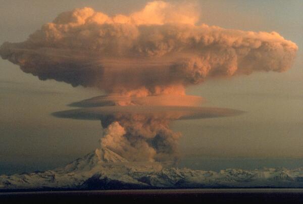
Ascending eruption cloud from Redoubt Volcano as viewed to the west from the Kenai Peninsula. The mushroom-shaped plume rose from avalanches of hot debris (pyroclastic flows) that cascaded down the north flank of the volcano. A smaller, white steam plume rises from the summit crater.
Ascending eruption cloud from Redoubt Volcano as viewed to the west from the Kenai Peninsula. The mushroom-shaped plume rose from avalanches of hot debris (pyroclastic flows) that cascaded down the north flank of the volcano. A smaller, white steam plume rises from the summit crater.

Aerial view of pāhoehoe flow encroaching on the Kalapana community. Hakuma horst, a raised fault block, is on the left. To the right of the point are fishponds, and to their right, Walter's Kalapana Store and Drive Inn. In the large trapezoidal plot are Mauna Kea Congregational Church and hall.
Aerial view of pāhoehoe flow encroaching on the Kalapana community. Hakuma horst, a raised fault block, is on the left. To the right of the point are fishponds, and to their right, Walter's Kalapana Store and Drive Inn. In the large trapezoidal plot are Mauna Kea Congregational Church and hall.

Dusting of Redoubt Volcano ash on snow, Indian, Alaska, February 21, 1990.
Dusting of Redoubt Volcano ash on snow, Indian, Alaska, February 21, 1990.

View looking uphill at surface flows advancing down a steep slope (Pulama pali) between the east rift zone and the coastal plain of Kīlauea Volcano. Overflows from the channel on the right are building levees of pāhoehoe. Within a few days, crust accreting inward from the levees built a roof over the channel, forming a new lava tube.
View looking uphill at surface flows advancing down a steep slope (Pulama pali) between the east rift zone and the coastal plain of Kīlauea Volcano. Overflows from the channel on the right are building levees of pāhoehoe. Within a few days, crust accreting inward from the levees built a roof over the channel, forming a new lava tube.

An automobile lies crushed under the third story of this apartment building in the Marina District. The ground levels are no longer visible because of structural failure and sinking due to liquefaction.
An automobile lies crushed under the third story of this apartment building in the Marina District. The ground levels are no longer visible because of structural failure and sinking due to liquefaction.