U.S. flag

An official website of the United States government

Images

Images related to natural hazards.

Filter Total Items: 7275
image related to volcanoes. See description
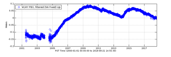
Vertical deformation at GPS station WLWY during 2001-2018

Data from continuous GPS stations indicate how the ground is moving over time. Station WLWY, near White Lake on the Sour Creek resurgent dome in Yellowstone caldera, has been operating since 2001. This plot shows vertical ground motion recorded at the site.

Data from continuous GPS stations indicate how the ground is moving over time. Station WLWY, near White Lake on the Sour Creek resurgent dome in Yellowstone caldera, has been operating since 2001. This plot shows vertical ground motion recorded at the site.

People are wearing wet suits and waders and are holding hand-held computers and backpacks with equipment in them, smiling.
Synchronized mapping

USGS and Washington State Department of Ecology scientists are geared up and ready to start a topographic survey at the mouth of the Elwha River, using handheld computers and backpack-mounted GPS equipment. From left to right are Owen Warrick (USGS Volunteer), Jon Warrick (USGS), Andy Ritchie (USGS), Heather Weiner (WA State Dept.

USGS and Washington State Department of Ecology scientists are geared up and ready to start a topographic survey at the mouth of the Elwha River, using handheld computers and backpack-mounted GPS equipment. From left to right are Owen Warrick (USGS Volunteer), Jon Warrick (USGS), Andy Ritchie (USGS), Heather Weiner (WA State Dept.

image related to volcanoes. See description
Cooling lava in Kīlauea Volcano's lower East Rift Zone continues to pose ha

View from the bank of the cooling lava channel near the Leilani Estates subdivision. The height difference between the channel (right) and upper bank (left) is about 8 m (26 ft). Although lava is not flowing from fissure 8, the lava flow field includes large areas of still-hot, rugged, and unstable lava surfaces.

View from the bank of the cooling lava channel near the Leilani Estates subdivision. The height difference between the channel (right) and upper bank (left) is about 8 m (26 ft). Although lava is not flowing from fissure 8, the lava flow field includes large areas of still-hot, rugged, and unstable lava surfaces.

image related to volcanoes. See description
Conditions evolve at ocean entry, in Kīlauea Volcano's lower East Rift Zone

View from this morning's helicopter overflight of the Pohoiki boat ramp at Isaac Hale Park shows black sand, transported to the southwest by longshore currents, blocking the entrance to the small boat harbor.

image related to volcanoes. See description
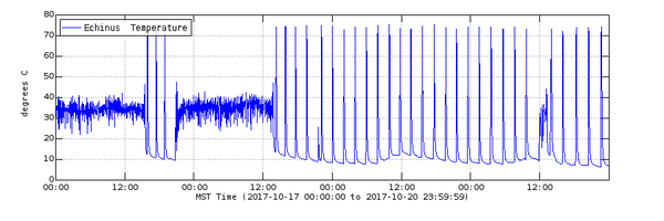
Echinus temperature record during October 17-20, 2017

Temperature record from Echinus geyser outflow channel for October 17–20, 2017. The plot captures a time when the geyser went from occasional eruptions to semi-regular eruptions (signified by temperature spikes after about 12:00 on October 18) occurring about every 2 hours.

Temperature record from Echinus geyser outflow channel for October 17–20, 2017. The plot captures a time when the geyser went from occasional eruptions to semi-regular eruptions (signified by temperature spikes after about 12:00 on October 18) occurring about every 2 hours.

image related to volcanoes. See description
A sand bar has built up at the end of the Pohoiki boat ramp, but the ramp itself

A sand bar has built up at the end of the Pohoiki boat ramp, but the ramp itself remains intact and there has been no significant lava advance toward the ramp in recent days.

image related to volcanoes. See description
Monitoring old ground cracks

Fissure 8 may have slowed down, but HVO scientists are still on the ground in Leilani Estates, monitoring old ground cracks and marking ones that haven't been surveyed before. Monitoring these cracks over multiple days could detect any new signs of magma movement beneath the ground, one of the indicators that fissures might reactivate.

Fissure 8 may have slowed down, but HVO scientists are still on the ground in Leilani Estates, monitoring old ground cracks and marking ones that haven't been surveyed before. Monitoring these cracks over multiple days could detect any new signs of magma movement beneath the ground, one of the indicators that fissures might reactivate.

image related to volcanoes. See description
Kīlauea lower East Rift Zone remains quiet

Today's morning overflight saw no new activity at any of the fissures in the lower East Rift Zone. Fissure 8 had only a sluggish lava puddle remaining in the cone, and other fissures, though steaming, showed no signs of reactivation.

Today's morning overflight saw no new activity at any of the fissures in the lower East Rift Zone. Fissure 8 had only a sluggish lava puddle remaining in the cone, and other fissures, though steaming, showed no signs of reactivation.

image related to volcanoes. See description
Thermal map of fissure system and lava flows

This thermal map shows the fissure system and lava flows as of 6 am on Saturday, August 11. Residual lava in the Fissure 8 flow continues to drain, feeding numerous small ocean entries (shown in main map). In the Fissure 8 cone there were two small lava ponds (shown in small inset map). The black and white area is the extent of the thermal map.

This thermal map shows the fissure system and lava flows as of 6 am on Saturday, August 11. Residual lava in the Fissure 8 flow continues to drain, feeding numerous small ocean entries (shown in main map). In the Fissure 8 cone there were two small lava ponds (shown in small inset map). The black and white area is the extent of the thermal map.

image related to volcanoes. See description
Volcanic activity diminished on Kīlauea's lower East Rift Zone

The UAS team (Unmanned Aircraft Systems) flew a mission over fissure 8 to assess conditions within the cinder cone. As shown, fissure 8 contains two small ponds deep within its crater. One pond slowly circulates with an incandescent surface while the other pond is stagnant with a crusted top.

The UAS team (Unmanned Aircraft Systems) flew a mission over fissure 8 to assess conditions within the cinder cone. As shown, fissure 8 contains two small ponds deep within its crater. One pond slowly circulates with an incandescent surface while the other pond is stagnant with a crusted top.

image related to volcanoes. See description
Kīlauea summit
Kīlauea summit
Kīlauea summit

Clear weather this afternoon afforded a stunning view of Kīlauea's summit, which has been "quiet" since August 4, with no significant subsidence or collapses. The flat ledge shown here (center) is part of the former Halema‘uma‘u crater floor, which dropped precipitously between mid-May and early August.

Clear weather this afternoon afforded a stunning view of Kīlauea's summit, which has been "quiet" since August 4, with no significant subsidence or collapses. The flat ledge shown here (center) is part of the former Halema‘uma‘u crater floor, which dropped precipitously between mid-May and early August.

image related to volcanoes. See description
Kīlauea Summit
Kīlauea Summit
Kīlauea Summit

As the Halema‘uma‘u Crater has collapsed, geologists have been able to see older volcanic deposits and features buried beneath decades of lava flows. For instance, two lava tubes were spotted in the southwestern wall of the collapse crater.

As the Halema‘uma‘u Crater has collapsed, geologists have been able to see older volcanic deposits and features buried beneath decades of lava flows. For instance, two lava tubes were spotted in the southwestern wall of the collapse crater.

image related to volcanoes. See description
Kīlauea's lower East Rift Zone lava flows and fissures, August 9, 2:00 p.m.

Map as of 2:00 p.m. HST, August 9, 2018. Given the dynamic nature of Kīlauea's lower East Rift Zone eruption, with changing vent locations, fissures starting and stopping, and varying rates of lava effusion, map details shown here are accurate as of the date/time noted. Shaded purple areas indicate lava flows erupted in 1840, 1955, 1960, and 2014-2015.

Map as of 2:00 p.m. HST, August 9, 2018. Given the dynamic nature of Kīlauea's lower East Rift Zone eruption, with changing vent locations, fissures starting and stopping, and varying rates of lava effusion, map details shown here are accurate as of the date/time noted. Shaded purple areas indicate lava flows erupted in 1840, 1955, 1960, and 2014-2015.

image related to volcanoes. See description
Death Gulch in 1899
Death Gulch in 1899
Death Gulch in 1899

The carcass of a large silver-tipped grizzly bear, which succumbed to poisonous gases in the area known as "Death Gulch" in Yellowstone National Park in 1897. Image from Popular Science Monthly Volume 54, Public Domain, accessed from https://commons.wikimedia.org/w/index.php?curid=15271684.

The carcass of a large silver-tipped grizzly bear, which succumbed to poisonous gases in the area known as "Death Gulch" in Yellowstone National Park in 1897. Image from Popular Science Monthly Volume 54, Public Domain, accessed from https://commons.wikimedia.org/w/index.php?curid=15271684.

image related to volcanoes. See description
There were small active ooze outs near the coast on the Kapoho Bay and Ahalanui

There were small active ooze outs near the coast on the Kapoho Bay and Ahalanui lobes but the laze plume was greatly diminished. Active lava is close to the Pohoiki boat ramp but has not advanced significantly toward it.

Photographs looking at a coastal cliff with a road covered by a landslide, then debris is cleared and road is repaired.
Mud Creek landslide changes March 2017-June 2018

USGS scientists produced an animated GIF in coordination with the California Department of Transportation (Caltrans) re-opening of State Highway 1 through Big Sur on July 18, 2018. In 2017, the massive Mud Creek landslide buried a quarter-mile of the famous coastal route with rocks and dirt more than 65 feet deep.

USGS scientists produced an animated GIF in coordination with the California Department of Transportation (Caltrans) re-opening of State Highway 1 through Big Sur on July 18, 2018. In 2017, the massive Mud Creek landslide buried a quarter-mile of the famous coastal route with rocks and dirt more than 65 feet deep.

image related to volcanoes. See description
Aerial view of an open channel west of Kapoho Crater. According to geologists fl

Aerial view of an open channel west of Kapoho Crater. According to geologists flying over the area, the flow appeared be the result of draining from the upslope channel; no discernible movement was observed.

image related to volcanoes. See description
A diffuse laze plume this morning afforded a clear view of Isaac Hale Beach Park

A diffuse laze plume this morning afforded a clear view of Isaac Hale Beach Park and the ocean entry, which was being fed across a broad front by viscous pāhoehoe. Lava flows in this area have thus far spared the Pohoiki boat ramp, visible at left.

A diffuse laze plume this morning afforded a clear view of Isaac Hale Beach Park and the ocean entry, which was being fed across a broad front by viscous pāhoehoe. Lava flows in this area have thus far spared the Pohoiki boat ramp, visible at left.

image related to volcanoes. See description
Thermal map of fissure system and lava flows

This thermal map shows the fissure system and lava flows as of 12:30 pm on Friday, August 3. The fountain at Fissure 8 remains active, with the lava flow entering the ocean. The dominant ocean entry points were on the section of coastline near Ahalanui. The black and white area is the extent of the thermal map.

This thermal map shows the fissure system and lava flows as of 12:30 pm on Friday, August 3. The fountain at Fissure 8 remains active, with the lava flow entering the ocean. The dominant ocean entry points were on the section of coastline near Ahalanui. The black and white area is the extent of the thermal map.

Was this page helpful?