



Scientists Cordell Johnson, left, and Li Erikson stand atop the coastal bluff of Barter Island in northern Alaska, a coastal area that is experiencing very high rates of erosion.
Images
Images related to natural hazards.
Filter Total Items: 7278

Barter Island coastal bluff studies
Scientists Cordell Johnson, left, and Li Erikson stand atop the coastal bluff of Barter Island in northern Alaska, a coastal area that is experiencing very high rates of erosion.

Kīlauea Volcano — Fissure 8 Lava Flow
Fissure 8 and the upper lava channel, viewed from the early morning helicopter overflight of the lower East Rift Zone. Recent heavy rains have soaked into the still-warm tephra and the moisture rises as steam (right side of lava channel).
Fissure 8 and the upper lava channel, viewed from the early morning helicopter overflight of the lower East Rift Zone. Recent heavy rains have soaked into the still-warm tephra and the moisture rises as steam (right side of lava channel).

Kīlauea Volcano — Geologist Making Observations of Fissure 8
Kīlauea Volcano — Geologist Making Observations of Fissure 8Fisheye lens photograph of a USGS geologist making observations of the fissure 8 lava channel at sunset July 3, 2018. The field crew is at a high point overlooking the channel near where it makes a 90 degree turn around Kapoho Crater and flows south.
Kīlauea Volcano — Geologist Making Observations of Fissure 8
Kīlauea Volcano — Geologist Making Observations of Fissure 8Fisheye lens photograph of a USGS geologist making observations of the fissure 8 lava channel at sunset July 3, 2018. The field crew is at a high point overlooking the channel near where it makes a 90 degree turn around Kapoho Crater and flows south.

Eroding bluffs in Kaktovik
View looking east of the actively eroding coastal permafrost bluff on Barter Island, which is located on the northern coast of Alaska.
View looking east of the actively eroding coastal permafrost bluff on Barter Island, which is located on the northern coast of Alaska.

Kīlauea Volcano — Drone Over Lava Channel
USGS Mavic Pro drone image of the fissure 8 lava channel looking toward the vent. Overflows can be seen as incandescent spots beyond the channel margins. Drone flights and resultant imagery help scientists better identify areas of channel overflows and active flow advancement.
USGS Mavic Pro drone image of the fissure 8 lava channel looking toward the vent. Overflows can be seen as incandescent spots beyond the channel margins. Drone flights and resultant imagery help scientists better identify areas of channel overflows and active flow advancement.

Kīlauea Volcano — Lava at Kapoho Beach Lots
At the coast, the northern margin of the flow field is still oozing pasty lava at several points in the area of Kapoho Beach Lots.
At the coast, the northern margin of the flow field is still oozing pasty lava at several points in the area of Kapoho Beach Lots.

Kīlauea Volcano — Open Lava Channels
Fountains from Fissure 8 spatter cone continue to supply lava to the open channel with intermittent small, short-lived overflows. Overflows appear as lighter gray to silver areas on the margins of the channel.
Fountains from Fissure 8 spatter cone continue to supply lava to the open channel with intermittent small, short-lived overflows. Overflows appear as lighter gray to silver areas on the margins of the channel.

Kīlauea Volcano — Fissure 8 Channel (Annotated)
Annotated drone image of Kīlauea Volcano's lower East Rift Zone fissure 8 lava channel. Image captured near Kapoho Crater looking east toward the ocean entry. Incandescent flow margin is more easily identified in the dark - specifically here in the area of Kapoho Beach Lots.
Annotated drone image of Kīlauea Volcano's lower East Rift Zone fissure 8 lava channel. Image captured near Kapoho Crater looking east toward the ocean entry. Incandescent flow margin is more easily identified in the dark - specifically here in the area of Kapoho Beach Lots.

Kīlauea Volcano — Overfows
Close up image of overflows from the fissure 8 lava channel. Photograph taken during the morning overflight.
Close up image of overflows from the fissure 8 lava channel. Photograph taken during the morning overflight.

Kīlauea Volcano — Ocean Entry
The ocean entry being fed by a crusted over channel has fewer tiny ooze-out channels than yesterday spilling into the water. One larger ooze-out channel making dominant entry plume at the northern end of the broad ocean entry.
The ocean entry being fed by a crusted over channel has fewer tiny ooze-out channels than yesterday spilling into the water. One larger ooze-out channel making dominant entry plume at the northern end of the broad ocean entry.

Night Shift
Woods Hole Coastal and Marine Science Center's Aerial Imaging and Mapping Unmanned Aerial Systems (UAS) pilots, Emily Sturdivant (left) and Elizabeth Pendleton (right) working the night shift in Hawaii at the Kileaua volcano site.
Woods Hole Coastal and Marine Science Center's Aerial Imaging and Mapping Unmanned Aerial Systems (UAS) pilots, Emily Sturdivant (left) and Elizabeth Pendleton (right) working the night shift in Hawaii at the Kileaua volcano site.

Kīlauea Volcano — Lava Channels from Fissure 8
Lava from fissure 8 is fed into a channel that travels about 13 km (8 mi) to the sea. A plumemarks the location of fissure 8, visible in the upper right; a small plume in the upper center marks the location of fissure 22.
Lava from fissure 8 is fed into a channel that travels about 13 km (8 mi) to the sea. A plumemarks the location of fissure 8, visible in the upper right; a small plume in the upper center marks the location of fissure 22.
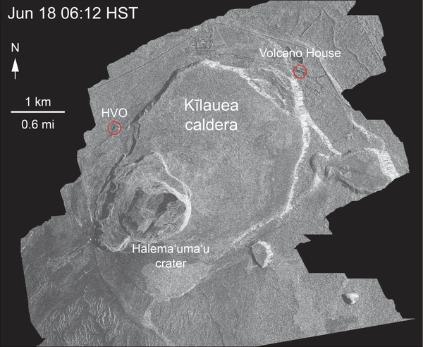
Kīlauea Volcano — Animation of Summit Drop
This animated GIF shows a sequence of radar amplitude images that were acquired by the Agenzia Spaziale Italiana CosmoSkyMed satellite system. The images illustrate changes to the caldera area of Kīlauea Volcano that occurred between May 5 and June 30 at about 6:00 a.m. HST.
This animated GIF shows a sequence of radar amplitude images that were acquired by the Agenzia Spaziale Italiana CosmoSkyMed satellite system. The images illustrate changes to the caldera area of Kīlauea Volcano that occurred between May 5 and June 30 at about 6:00 a.m. HST.

Kīlauea Volcano — Fissure 8
Fountains from the fissure 8 spatter cone continue to supply lava to an open channel.
Fountains from the fissure 8 spatter cone continue to supply lava to an open channel.

Kīlauea Volcano — Ocean Entry at Kapoho
Lava was entering the ocean over a broad area this morning. This image shows an active entry area along the northern flow front at Kapoho. View to the south.
Lava was entering the ocean over a broad area this morning. This image shows an active entry area along the northern flow front at Kapoho. View to the south.

Kīlauea Volcano — Lava Flowing Around Channel Islands
Kīlauea Volcano — Lava Flowing Around Channel IslandsLava flows around islands in the lava channel. The direction of flow is from the upper right to lower left. Field crews can make a rough calculation of velocity by timing large blocks as they pass between two landmarks that are a known distance apart.
Kīlauea Volcano — Lava Flowing Around Channel Islands
Kīlauea Volcano — Lava Flowing Around Channel IslandsLava flows around islands in the lava channel. The direction of flow is from the upper right to lower left. Field crews can make a rough calculation of velocity by timing large blocks as they pass between two landmarks that are a known distance apart.

Kīlauea Volcano — Kapoho Coast
At the Kapoho coast, lava enters the ocean along the northern margin of the flow field.
At the Kapoho coast, lava enters the ocean along the northern margin of the flow field.

Kīlauea Volcano — Summit Rockfalls
View of Kīlauea Volcano's summit. The brown visible dust coming from Halema‘uma‘u is from rockfalls.
View of Kīlauea Volcano's summit. The brown visible dust coming from Halema‘uma‘u is from rockfalls.

Kīlauea Volcano — Video Data of Fissure 8
Hawaiian Volcano Observatory geologist Matt Patrick acquires video of fissure 8 and the lava channel from Pohoiki Road/Highway 132. The video is used to document fountain behavior and lava flow characteristics, and how they change with time.
Hawaiian Volcano Observatory geologist Matt Patrick acquires video of fissure 8 and the lava channel from Pohoiki Road/Highway 132. The video is used to document fountain behavior and lava flow characteristics, and how they change with time.

Kīlauea Volcano — Laze Plumes
During the June 29 overflight, USGS scientists observed multiple active spots along the Kapoho ocean entry producing laze plumes.
During the June 29 overflight, USGS scientists observed multiple active spots along the Kapoho ocean entry producing laze plumes.

Kīlauea Volcano — Cracks and Deformation Map
High-resolution satellite data are useful for mapping cracks and deformation in the summit caldera at Kīlauea Volcano.
High-resolution satellite data are useful for mapping cracks and deformation in the summit caldera at Kīlauea Volcano.