



USGS scientist Cordell Johnson points to the Raspberry Shake, a sensitive instrument used to detect ground shaking. Johnson mounted the Raspberry Shake to an aluminum pole which he will then drive into the ground to bury the instrument beneath the tundra. This process will help isolate it from the wind.
Images
Images related to natural hazards.
Filter Total Items: 7278

Installing ground-shaking detection instrument
USGS scientist Cordell Johnson points to the Raspberry Shake, a sensitive instrument used to detect ground shaking. Johnson mounted the Raspberry Shake to an aluminum pole which he will then drive into the ground to bury the instrument beneath the tundra. This process will help isolate it from the wind.

Sensitive instrument used to detect ground shaking
Sensitive instrument used to detect ground shakingThis device, called a Raspberry Shake, is a sensitive instrument used to detect ground shaking. It is being carefully buried in this shallow hole in the tundra, to isolate it from wind.
Sensitive instrument used to detect ground shaking
Sensitive instrument used to detect ground shakingThis device, called a Raspberry Shake, is a sensitive instrument used to detect ground shaking. It is being carefully buried in this shallow hole in the tundra, to isolate it from wind.

Kīlauea Volcano — Lavafall Near Kapoho Crater
Near the Kapoho Crater, in the area called Four Corners, the lava channel makes a 90-degree bend. After lava exits the bend, it makes a short drop to form a lavafall. A side channel makes a short surface diversion before rejoining the existing channel.
Near the Kapoho Crater, in the area called Four Corners, the lava channel makes a 90-degree bend. After lava exits the bend, it makes a short drop to form a lavafall. A side channel makes a short surface diversion before rejoining the existing channel.

Kīlauea Volcano — Aerial of Kapoho Area
Aerial view of the lava channel and active margins between Kapoho Crater (upper right) and the coast (lower left). The northern margin of the flow field is advancing at several points in the area of Kapoho Ag and Beach Lots (vegetated areas in center of image). Image courtesy of Hawaii County Fire Department.
Aerial view of the lava channel and active margins between Kapoho Crater (upper right) and the coast (lower left). The northern margin of the flow field is advancing at several points in the area of Kapoho Ag and Beach Lots (vegetated areas in center of image). Image courtesy of Hawaii County Fire Department.

Kīlauea Volcano — Collapse and Dust Rising at Halema`uma`u Crater
Kīlauea Volcano — Collapse and Dust Rising at Halema`uma`u CraterAt 1:20 PM HST on July 5, a collapse explosion event occurred at Kīlauea's summit. The energy released by the event was equivalent to a M5.2 earthquake.
Kīlauea Volcano — Collapse and Dust Rising at Halema`uma`u Crater
Kīlauea Volcano — Collapse and Dust Rising at Halema`uma`u CraterAt 1:20 PM HST on July 5, a collapse explosion event occurred at Kīlauea's summit. The energy released by the event was equivalent to a M5.2 earthquake.

Kīlauea Volcano — Kapoho Coastline Delta
Lava enters the sea along the Kapoho coastline, building a delta that is now over 555 acres in size.
Lava enters the sea along the Kapoho coastline, building a delta that is now over 555 acres in size.

Kīlauea Volcano — Dust from Summit Explosion
Rocks generate brown dust as they tumble down the western caldera wall during the collapse explosion event on July 5, 2018.
Rocks generate brown dust as they tumble down the western caldera wall during the collapse explosion event on July 5, 2018.

Kīlauea Volcano — Lava Levees
Lava, from small overflows, cools and congeals along the banks of the lava channel to build lava levees. The levees also build up as moving lava pushes cooled crust over the edge.
Lava, from small overflows, cools and congeals along the banks of the lava channel to build lava levees. The levees also build up as moving lava pushes cooled crust over the edge.

Kīlauea Volcano — Flows Near Kapoho Ag. and Beach Lots
Kīlauea Volcano — Flows Near Kapoho Ag. and Beach LotsNear the coast, the northern margin of the flow field is still oozing pasty lava at several points in the area of Kapoho Agricultural and Beach Lots.
Kīlauea Volcano — Flows Near Kapoho Ag. and Beach Lots
Kīlauea Volcano — Flows Near Kapoho Ag. and Beach LotsNear the coast, the northern margin of the flow field is still oozing pasty lava at several points in the area of Kapoho Agricultural and Beach Lots.

Kīlauea Volcano — Fissure 8 at Night
USGS Unmanned Aircraft Systems image of fissure 8 looking east.
USGS Unmanned Aircraft Systems image of fissure 8 looking east.

Kīlauea Volcano — Lava Channel Bend
The lava channel from fissure 8 jumped its banks near Kapoho Crater where the channel makes a 90 degree bend. The flow within the channel was diverted around a constricted area and joined the channel again "downstream" to the south (left).
The lava channel from fissure 8 jumped its banks near Kapoho Crater where the channel makes a 90 degree bend. The flow within the channel was diverted around a constricted area and joined the channel again "downstream" to the south (left).

Kīlauea Volcano — Sunrise at Haleam`uma`u Crater
Sunrise view of Halema‘uma‘u crater as seen from the USGS observation point from Volcano House in Hawai‘i Volcanoes National Park.
Sunrise view of Halema‘uma‘u crater as seen from the USGS observation point from Volcano House in Hawai‘i Volcanoes National Park.

Kīlauea Volcano — Scientist Observing Fissure 8
USGS scientist observes the glow of fissure 8 fountain and channel within Leilani Estates. Steam rises from cracks and hot spots within the tephra deposit surrounding the cone.
USGS scientist observes the glow of fissure 8 fountain and channel within Leilani Estates. Steam rises from cracks and hot spots within the tephra deposit surrounding the cone.
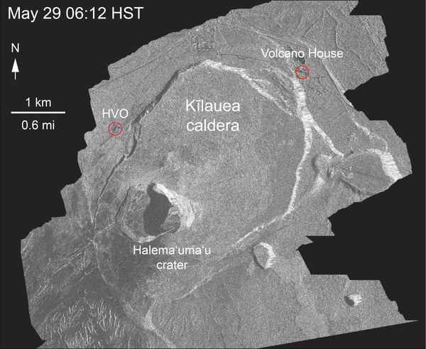
Kīlauea Volcano — Animation of Summit Subsidence
This animated GIF shows a sequence of radar amplitude images that were acquired by the Agenzia Spaziale Italiana CosmoSkyMed satellite system. The images illustrate changes to the caldera area of Kīlauea Volcano that occurred between May 5 and July 4 at about 6:00 a.m. HST.
This animated GIF shows a sequence of radar amplitude images that were acquired by the Agenzia Spaziale Italiana CosmoSkyMed satellite system. The images illustrate changes to the caldera area of Kīlauea Volcano that occurred between May 5 and July 4 at about 6:00 a.m. HST.

Kīlauea Volcano — Lava Flowing from Fissure 8
Lava within the fissure 8 cone roils and churns where it eupts from the vent and flows rapidly down the well-established channel. This image was captured via a Mavic Pro drone courtesy of the DOI/USGS Unmanned Aircraft Systems team.
Lava within the fissure 8 cone roils and churns where it eupts from the vent and flows rapidly down the well-established channel. This image was captured via a Mavic Pro drone courtesy of the DOI/USGS Unmanned Aircraft Systems team.

Kīlauea Volcano — Fissure 8 Flow at Night
During the overnight hours, the UAS (Unoccupied Aircraft Systems) team flew sections of the lower East Rift Zone, monitoring fissure 8 activity and reports of small overflows from the lava channel.
During the overnight hours, the UAS (Unoccupied Aircraft Systems) team flew sections of the lower East Rift Zone, monitoring fissure 8 activity and reports of small overflows from the lava channel.

Kīlauea Volcano — Sunrise at Halema`uma`u Crater
Inward slumping of Halema‘uma‘u continues in response to ongoing subsidence at Kīlauea Volcano's summit. This image, taken from a temporary observation post located at Volcano House, shows steep walls on the western side of the crater and sloping piles of rubble from rockfall events.
Inward slumping of Halema‘uma‘u continues in response to ongoing subsidence at Kīlauea Volcano's summit. This image, taken from a temporary observation post located at Volcano House, shows steep walls on the western side of the crater and sloping piles of rubble from rockfall events.

PCMSC vessel Jewell on its towing trailer
USGS PCMSC vessel Jewell, shown on its towing trailer in the wareyard of MarFac in Santa Cruz, CA.
USGS PCMSC vessel Jewell, shown on its towing trailer in the wareyard of MarFac in Santa Cruz, CA.

Kīlauea Volcano — Evolution of a Blocked Channel (Part 2)
Kīlauea Volcano — Evolution of a Blocked Channel (Part 2)Evolution of a blocked channel, image 2: While observing this area of the fissure 8 lava channel near Kapoho cone during the morning overflight, geologists witnesed an "apartment-building-sized" blockage within the channel give way and be pushed down stream by the pressurized lava behind.
Kīlauea Volcano — Evolution of a Blocked Channel (Part 2)
Kīlauea Volcano — Evolution of a Blocked Channel (Part 2)Evolution of a blocked channel, image 2: While observing this area of the fissure 8 lava channel near Kapoho cone during the morning overflight, geologists witnesed an "apartment-building-sized" blockage within the channel give way and be pushed down stream by the pressurized lava behind.

Kīlauea Volcano — Evolution of a Blocked Channel (Part 1)
Kīlauea Volcano — Evolution of a Blocked Channel (Part 1)Evolution of a blocked channel, photo 1. A blockage of rafted material within the lava channel causes lava to flow over its banks near the Kapoho cone. In this section of the lava channel a cold lava flow from the 1960 eruption forms a barrier on the north side, which initially directed the channel to the southeast.
Kīlauea Volcano — Evolution of a Blocked Channel (Part 1)
Kīlauea Volcano — Evolution of a Blocked Channel (Part 1)Evolution of a blocked channel, photo 1. A blockage of rafted material within the lava channel causes lava to flow over its banks near the Kapoho cone. In this section of the lava channel a cold lava flow from the 1960 eruption forms a barrier on the north side, which initially directed the channel to the southeast.

Actively eroding coastal permafrost bluff on Barter Island
Actively eroding coastal permafrost bluff on Barter IslandPhotograph of the actively eroding coastal permafrost bluff on Barter Island, located on the northern coast of Alaska.
Actively eroding coastal permafrost bluff on Barter Island
Actively eroding coastal permafrost bluff on Barter IslandPhotograph of the actively eroding coastal permafrost bluff on Barter Island, located on the northern coast of Alaska.