Kīlauea LERZ Fissures & Flows, May 21 at 8:00 a.m.
Kīlauea LERZ Fissures & Flows, May 21 at 8:00 a.m.Map as of 8:00 am HST, May 21. Shaded purple areas indicate lava flows erupted in 1840, 1955, 1960, and 2014-2015.
An official website of the United States government
Here's how you know
Official websites use .gov
A .gov website belongs to an official government organization in the United States.
Secure .gov websites use HTTPS
A lock () or https:// means you’ve safely connected to the .gov website. Share sensitive information only on official, secure websites.
Images related to natural hazards.
Map as of 8:00 am HST, May 21. Shaded purple areas indicate lava flows erupted in 1840, 1955, 1960, and 2014-2015.
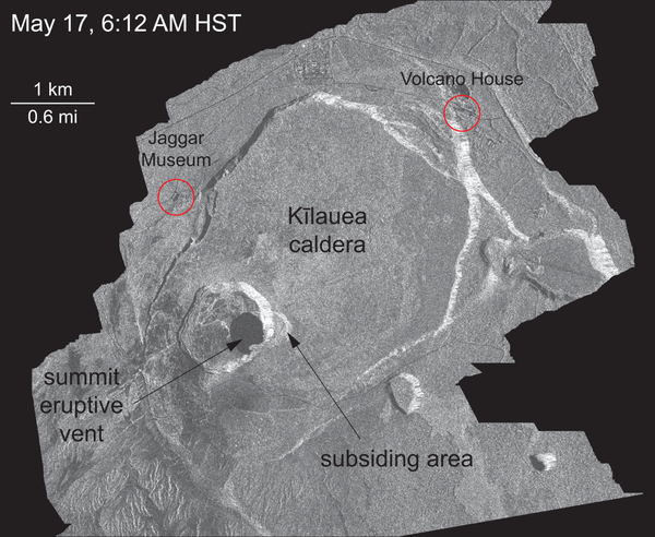
This animated GIF shows a sequence of radar amplitude images that were acquired by the Italian Space Agency's Cosmo-SkyMed satellite system. The series shows changes to the caldera area of Kīlauea Volcano that occurred over May 5 at 6:12 a.m. HST, May 17 at 6:12 a.m. HST, and May 21 at 6:12 a.m. HST.
This thermal map shows the fissure system and lava flows as of 12:15 pm on Monday, May 21. The primary lava flows originate from the Fissure 20-22 area. The dominant ocean entry is marked. The black and white area is the extent of the thermal map.
By the end of the afternoon, only a single ocean entry was active. The lava channel originates from fissure 22. This photo was taken during a late afternoon overflight of the lower East Rift Zone, Kīlauea Volcano.
Helicopter overflight of Kīlauea Volcano's Lower East Rift Zone shows fountaining at Fissure 22.
By the end of the afternoon, only a single ocean entry was active. The lava channel originates from fissure 22. This photo was taken during a late afternoon overflight of the lower East Rift Zone, Kīlauea Volcano.
This thermal map shows the fissure system and lava flows as of 12:15 pm on Saturday, May 19. The two primary lava flows originate from the Fissure 20-22 area, and crossed Pohoiki Road over the past day. The flow front position based on a 6:40 pm update is shown by the red circle. The black and white area is the extent of the thermal map.
Lava flows from the Fissure 20 complex move downslope and enter the ocean. Lava can be seen in the middle of the channel. A laze plume hides the point of ocean entry.
Lava from the eastern channel of the Fissure 20 complex is flowing into a crack in the ground that opened on the morning of May 20, 2018. The crack is "robbing" the easternmost channel of lava and the eastern ocean entry is therefore less vigorous than the western entry point.
Map as of 11:00 am HST, May 20. Shaded purple areas indicate lava flows erupted in 1840, 1955, 1960, and 2014-2015. Site of active ocean entry is shown with dots.
Late last night, the fissure 20 lava flow reached the ocean. Hot lava entering the ocean creates a dense white plume called "laze" (short for "lava haze"). Laze is formed as hot lava boils seawater to dryness.
Video of a slow moving lava flow in Kīlauea Volcano's lower East Rift Zone, taken May 20, 2018, at around 2:31 AM HST. The flow is ~3 m (9 ft) high. The HVO scientist mapping the flow is about ~15 m (50 ft) away from the flow front. The audio is the sound of burning vegetation and the call of coqui frogs.
Lava from the Fissure 20 complex enters the ocean generating a white laze plume. Helicopter overflight on May 20, 2018, at 6:45 AM HST.
A plume rises from the site of the lava ocean entry, viewed on approach by HVO scientists during an overflight of Kīlauea Volcano's lower East Rift Zone on May 20, 2018, around 6:45 AM HST.
Ocean entry photograph from Civil Air Patrol (CAP) overflight taken at about 12:50PM. CAP operates to support the mission of both the USGS HVO and the Hawaii County Civil Defense. Hard to discern here, but there are two entries. The coastal area spanning the entry is about 1 km (0.6 mi) wide with an about 250 m (0.15 mi) Kīpuka separating the two.
View of ocean entry point from helicopter overflight on May 20, 2018, at 6:45 AM HST.
Lava from the Fissure 20 complex is entering the ocean in two locations, separated by an area tens of yards wide. At the time of this early morning photo, lava flowing into the ocean entry on the eastern (left-most) lobe was diminishing while lava flowing into the ocean on the western (right-most) lobe was vigorous.
Lava from the eastern channel of the Fissure 20 complex flows into a crack in the ground. The crack opened in the early morning hours of May 20, 2018. Prior to opening, lava was flowing vigorously down a channel. After the crack formed, the lava began pouring into the ground.
The helicopter hovers above the ocean entry on May 20, 2018, around 6:45 AM HST. Several braided lava channels (red) are visible on the right. The white plume is "laze," which forms when hot lava hits the ocean sending hydrochloric acid and steam with fine glass particles into the air.
Ocean entry photograph from Civil Air Patrol (CAP) overflight taken at about 12:50PM. CAP operates to support the mission of both the USGS HVO and the Hawaii County Civil Defense. Hard to discern here, but there are two entries. The coastal area spanning the entry is about 1 km (0.6 mi) wide with an about 250 m (0.15 mi) Kīpuka separating the two.