
This animated GIF shows a sequence of radar amplitude images that were acquired by the Italian Space Agency's Cosmo-SkyMed satellite system. The series shows changes to the caldera area of Kīlauea Volcano that occurred over May 5 at 6:12 a.m. HST, May 17 at 6:12 a.m.
Images
Images related to natural hazards.
Filter Total Items: 7275

Kīlauea Volcano — Animation of Summit Enlargement
This animated GIF shows a sequence of radar amplitude images that were acquired by the Italian Space Agency's Cosmo-SkyMed satellite system. The series shows changes to the caldera area of Kīlauea Volcano that occurred over May 5 at 6:12 a.m. HST, May 17 at 6:12 a.m.

Tephra (airborne lava fragments) erupted by the high lava fountains...
Tephra (airborne lava fragments) erupted by the high lava fountains...Tephra (airborne lava fragments) erupted by the high lava fountains of fissure 8 was carried downwind, where the frothy rock fragments fell on Leilani Street, just past Kupono Street, in the Leilani Estates subdivision.

Kīlauea LERZ Fissures and Flows, May 29, 6:00 p.m.
Kīlauea LERZ Fissures and Flows, May 29, 6:00 p.m.Map as of 6:00 p.m. HST, May 29, 2018. Given the dynamic nature of Kīlauea's lower East Rift Zone eruption, with changing vent locations, fissures starting and stopping, and varying rates of lava effusion, map details shown here are accurate as of the date/time noted—and could have changed rapidly since that time.

Video of fissure 8, as observed during a helicopter overflight on M...
Video of fissure 8, as observed during a helicopter overflight on M...Video of fissure 8, as observed during a helicopter overflight on May 29, 2018, and as viewed from ground level. Fissure 8 was fountaining to heights of 200 feet at times, and feeding a lava flow that was traveling to the northeast.
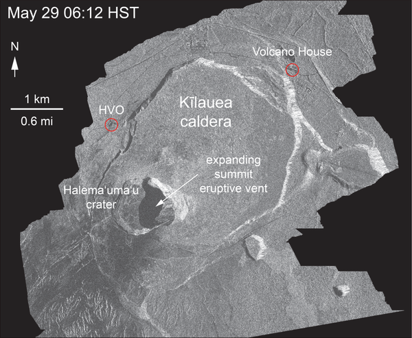
Radar image from May 29 shows enlargement of summit eruptive vent
Radar image from May 29 shows enlargement of summit eruptive ventThis animated GIF shows a sequence of radar amplitude images that were acquired by the Italian Space Agency's Cosmo-SkyMed satellite system. The series shows changes to the caldera area of Kīlauea Volcano that occurred over May 5 at 6:12 a.m. HST, May 17 at 6:12 a.m. HST, May 21 at 6:12 a.m. HST, and May 29 at 6:12 a.m. HST.

Overflight confirms weak ocean entry, in Kīlauea's LERZ
Overflight confirms weak ocean entry, in Kīlauea's LERZScientists on the early morning overflight of Kīlauea Volcano's lower East Rift Zone documented a very weak ocean entry. For the easternmost lobe, only a few small finger channels of lava were entering the ocean.

Fissure 8 reactivated on the afternoon of May 28 and at times, was ...
Fissure 8 reactivated on the afternoon of May 28 and at times, was ...Fissure 8 reactivated on the afternoon of May 28 and at times, was fountaining to heights of 200 feet and feeding a lava flow traveling to the northeast.
Fissure 8 reactivated on the afternoon of May 28 and at times, was ...
Fissure 8 reactivated on the afternoon of May 28 and at times, was ...Fissure 8 reactivated on the afternoon of May 28 and at times, was fountaining to heights of 200 feet and feeding a lava flow traveling to the northeast.

Close view of weak ocean entry
Close view of weak ocean entry at about 1:05 p.m. HST. Only small and intermittent "laze" plumes have been observed today. The vents that supplied lava to the flow and sea stopped erupting overnight, and only residual lava still hot within the flow occasionally spilled into the sea today.
Close view of weak ocean entry at about 1:05 p.m. HST. Only small and intermittent "laze" plumes have been observed today. The vents that supplied lava to the flow and sea stopped erupting overnight, and only residual lava still hot within the flow occasionally spilled into the sea today.

View of the now-sluggish lava flow that crossed Pohoiki Road earlie...
View of the now-sluggish lava flow that crossed Pohoiki Road earlie...View of the now-sluggish lava flow that crossed Pohoiki Road earlier today; the flow originated from fissure 8. This fissure was very active overnight, slowed this morning, and stopped by about noon. During the close of an overflight this afternoon, lava began erupting downrift of fissure 8 in the area between about fissure 7 and 21 (low fountains in upper right).

Thermal map of fissure system and lava flows
This thermal map shows the fissure system and lava flows as of 1:15 pm on Monday, May 28. The flow from Fissure 8 that reached Pohoiki Rd. this morning stalled, though activity restarted at Fissure 8 in the afternoon shortly after this map was made.
This thermal map shows the fissure system and lava flows as of 1:15 pm on Monday, May 28. The flow from Fissure 8 that reached Pohoiki Rd. this morning stalled, though activity restarted at Fissure 8 in the afternoon shortly after this map was made.

Kīlauea Volcano — Fissure Complex
View of the fissure complex looking toward the southwest (uprift) during this afternoon's overflight at about 1:15 p.m. HST. The small lava flows spreading to the southeast from the fissure complex (lower middle) originate in the area of between fissures 16 and 18.
View of the fissure complex looking toward the southwest (uprift) during this afternoon's overflight at about 1:15 p.m. HST. The small lava flows spreading to the southeast from the fissure complex (lower middle) originate in the area of between fissures 16 and 18.

Kīlauea Volcano — Lava Flow Crossing Pohoiki Road
Aerial view of active lava flow crossing Pohoiki Road during an overflight this morning about 7 a.m. HST. Pohoiki Road cuts through middle of photograph.
Aerial view of active lava flow crossing Pohoiki Road during an overflight this morning about 7 a.m. HST. Pohoiki Road cuts through middle of photograph.

Kīlauea Volcano — Fissure Complex
View of the fissurecomplex is toward the southeast during this afternoon's overflight of the lower East Rift Zone at about 1:15 p.m. HST. The lava channel in middle of photograph is filling with lava erupted from fissure 22.
View of the fissurecomplex is toward the southeast during this afternoon's overflight of the lower East Rift Zone at about 1:15 p.m. HST. The lava channel in middle of photograph is filling with lava erupted from fissure 22.

Kīlauea Volcano — Lava Channel and Fountains
Close view of lava channel in middle of the lava flow erupting from fissure 8 during this morning's overflight at about 7 a.m. HST. The tallest lava fountain is fissure 8, active since yesterday evening. The eruption rate at fissure 8 diminished significantly later in the morning.
Close view of lava channel in middle of the lava flow erupting from fissure 8 during this morning's overflight at about 7 a.m. HST. The tallest lava fountain is fissure 8, active since yesterday evening. The eruption rate at fissure 8 diminished significantly later in the morning.

Kilauea Volcano — Ocean Entry Aerial
Close view of weak ocean entry at about 1:05 p.m. HST. Only small and intermittent "laze" plumes have been observed today.
Close view of weak ocean entry at about 1:05 p.m. HST. Only small and intermittent "laze" plumes have been observed today.

Kilauea Volcano — Pohoiki Road Lava Flow
View of the now-sluggish lava flow that crossed Pohoiki Road earlier today; the flow originated from fissure 8. This fissure was very active overnight, slowed this morning, and stopped by about noon.
View of the now-sluggish lava flow that crossed Pohoiki Road earlier today; the flow originated from fissure 8. This fissure was very active overnight, slowed this morning, and stopped by about noon.

Kīlauea LERZ Fissures and Flows, May 28, 3:00 p.m.
Kīlauea LERZ Fissures and Flows, May 28, 3:00 p.m.Map as of 3:00 p.m. HST, May 28, 2018. Shaded purple areas indicate lava flows erupted in 1840, 1955, 1960, and 2014-2015.
Kīlauea LERZ Fissures and Flows, May 28, 3:00 p.m.
Kīlauea LERZ Fissures and Flows, May 28, 3:00 p.m.Map as of 3:00 p.m. HST, May 28, 2018. Shaded purple areas indicate lava flows erupted in 1840, 1955, 1960, and 2014-2015.

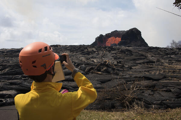
A volcanologist observes a lava fountain during the 2018 Kilauea eruption
A volcanologist observes a lava fountain during the 2018 Kilauea eruptionU.S. Geological Survey Volcanologist Matthew Patrick photographs and observes a lava fountain in the Leilani Estates near Hilo, Hawai`i on Sunday, May 27, 2018.

Kīlauea Volcano — Pāhoehoe Lava Advancement
Pāhoehoe lava advancing west from fissure 7 (lava fountain in background) on Leilani Avenue. Fissure 7 activity increased overnig
Pāhoehoe lava advancing west from fissure 7 (lava fountain in background) on Leilani Avenue. Fissure 7 activity increased overnig

Kīlauea Volcano — Aerial of Eastern-Most Fissure Complex
Kīlauea Volcano — Aerial of Eastern-Most Fissure ComplexAerial view of the eastern-most end of the fissure complex (top right) and active lava channels and inactive flows south of the fissures (toward left side of photo) at about 12:30 p.m. HST; the ocean is out of view left side of photo. In this view, fissure 22 in top right is supplying most of the lava to the active channel.