Drones, Mirrors, Gear Galore—Welcome to a Satellite Validation Event
An invasion of sorts took place recently in an alfalfa field in northeastern Brookings, SD.
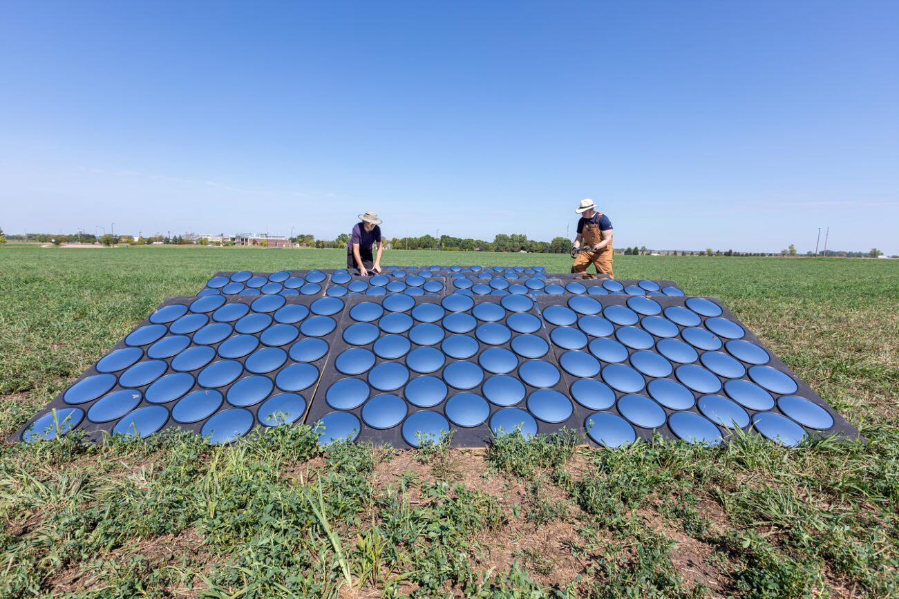
It wasn’t an invasion of unwanted species—though it does ultimately help monitor environmental issues. Rather, the field bustled with drones in the air, angled panels of mirrors and pools of water on the ground, and people roaming the field with gear and wands.

While the event centered on one field for about two days, its goal was to ensure that Landsat satellite data for the entire globe has the best accuracy and quality possible for use far into the future.
Landsat satellites collect data of each part of the Earth’s land surface every 16 days, so with two satellites in orbit, data is received every 8 days. The EROS Cal/Val Center of Excellence (ECCOE), along with partners from NASA and multiple universities, works to calibrate, and recalibrate, the satellite with a reference standard, and also to validate the accuracy of satellite products with ground surface measurements.
The ECCOE is based at the U.S. Geological Survey Earth Resources Observation and Science (EROS) Center at Sioux Falls, SD. EROS archives and distributes Landsat data.
A certain amount of field work is required to calibrate and validate, said Cody Anderson, the ECCOE project manager. EROS and its research partners have been calibrating in the field for decades, from Rail Road Valley, NV, to a special event in Tuz Golu, Turkey. ECCOE and South Dakota State University also go out to spots in eastern South Dakota for each Landsat pass.
Participants in this USGS/EROS-funded event, dubbed BigMAC, were validating surface temperature and surface reflectance products that have recently become globally available. They are called Level 2 products in the Landsat archive’s Collection 2.
The surface reflectance product can account for atmospheric effects such as thin cloud cover or aerosol scattering, thereby improving the ability for people to compare Landsat archive images over time for innumerable studies, from the histories of deforestation and fires to crop rotation. Surface temperature can help researchers characterize water consumption through irrigation, urban heat island effects, and more.
Comparing Multiple Methods
What made BigMAC unique from other validation work already performed was the goal to bring together multiple methods of validation and evaluate the different capabilities and results.
EROS and South Dakota State University (SDSU) showed up with the wands, which were actually analytical spectral devices (ASDs) with a fiber optic that measures the visible, infrared and ultraviolet ranges of the electromagnetic spectrum for surface reflectance.

White, dark, and colored panels were placed in the field to help calibrate the instruments before measurements of the vegetation were taken. Pools of water were set out to help measure surface temperature.
Research partners from the Rochester Institute of Technology (RIT) in New York drove halfway across the country with a trailer of unmanned aerial vehicles (UAVs) with a variety of sensors and ground-based thermal instruments to measure surface temperature and reflectance.
A commercial company, Labsphere, came from New Hampshire in a collaboration with SDSU and RIT to develop a calibration method involving mirrors that reflect sunlight toward the satellite. NASA Goddard Space Flight Center and NASA Jet Propulsion Laboratory—the other agencies referred to in the Multi-Agency Collection (MAC) part of the BigMAC title—were unable to attend.
Dennis Helder, a professor emeritus at SDSU and calibration expert who works part-time as an EROS contractor, coordinated the event. Fortunately, the weather cooperated to make the late August trip worthwhile for the 15 or so people who participated, although they started a day earlier than intended because of rain in the forecast later in the week. “We ended up getting as two near-perfect days as you could hope for in South Dakota to collect data,” Anderson said.
Measurements Look Promising
The next day after field work, each group did some preliminary processing. The groups gathered the following day to share some initial results and talk about lessons learned.
“The one thing you hope to see when you have several teams out there making similar measurements is that their measurements agree. That was the first thing that promises success is that all the teams’ measurements were in pretty good agreement,” Anderson said.
After having a chance to further evaluate their data, the groups plan to meet again in early 2022 to compare results. “This is really an intercomparison campaign where we’re looking at the methodologies of the different groups and trying to consolidate on a best process, and then to get each of the different groups to adopt that process,” Anderson said.
Scientists, land use managers, and others ultimately will benefit by using the most accurate Landsat data possible and generating studies and reports that can benefit people around the world in many ways.
If devices like mirrors or drones can help with that, then BigMAC measured just the right alfalfa field—at the intersection of Technology and Innovation Drives.