U.S. flag

An official website of the United States government

Multimedia

Webcams—Near-real-time images from webcams.

Videos—Collection of videos recorded during field excursions or caught on our webcams.

Image Galleries—Galleries of images and events with expanded descriptions.

The Kīlauea Photo and Video Chronology and Mauna Loa Photo and Video Chronology webpages also feature photos. 

Images

Color photograph of volcanic eruption
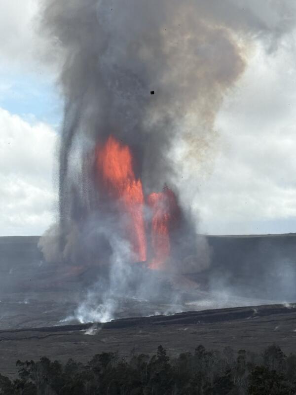
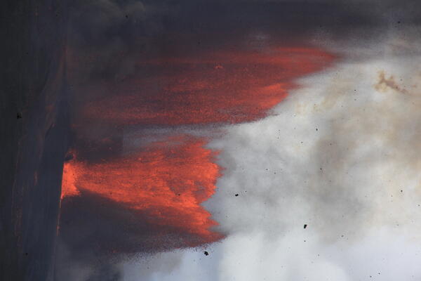
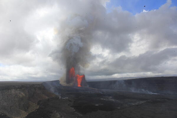
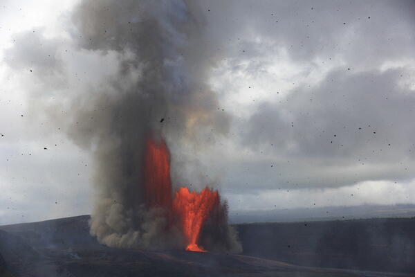
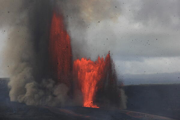
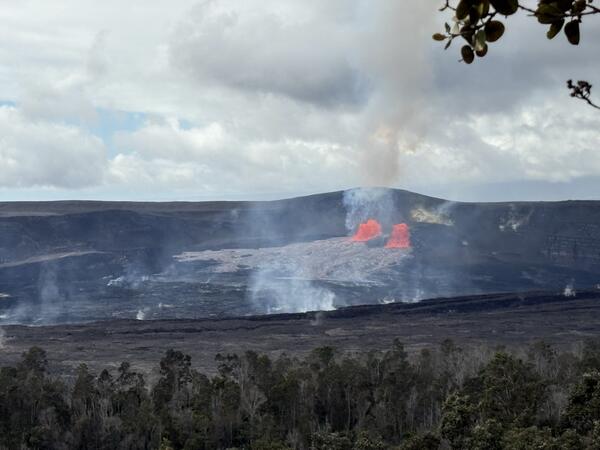
January 24, 2026 — The start of episode 41 lava fountaining at Kīlauea summit

This photograph was taken from Volcano House Hotel, in Hawaiʻi Volcanoes National Park at around 11:25 a.m. on January 24, 2026, around the time that the USGS Hawaiian Volcano Observatory declared the start of episode 41 of lava fountaining at the summit of Kīlauea.

This photograph was taken from Volcano House Hotel, in Hawaiʻi Volcanoes National Park at around 11:25 a.m. on January 24, 2026, around the time that the USGS Hawaiian Volcano Observatory declared the start of episode 41 of lava fountaining at the summit of Kīlauea.

Color photograph of lava fountains
January 24, 2026 — Kīlauea episode 41 lava fountains from the north and south vents

This photograph was taken at around 1:10 p.m. HST from the Volcano House Hotel within Hawaiʻi Volcanoes National Park. This photo shows the heights that the north and south vents achieved during episode 41 on January 24, with the latter reaching at least 450 m (about 1500 ft) at times.

This photograph was taken at around 1:10 p.m. HST from the Volcano House Hotel within Hawaiʻi Volcanoes National Park. This photo shows the heights that the north and south vents achieved during episode 41 on January 24, with the latter reaching at least 450 m (about 1500 ft) at times.

Color photograph of lava fountains
January 24, 2026 — Kīlauea episode 41 lava fountains

USGS Hawaiian Volcano Observatory scientists observed and documented episode 41 of the episodic Kīlauea summit eruption in Halema‘uma‘u. Lava fountains in both the north and south vents were active with maximum heights reaching 460-480 m (1500-1575 ft).

USGS Hawaiian Volcano Observatory scientists observed and documented episode 41 of the episodic Kīlauea summit eruption in Halema‘uma‘u. Lava fountains in both the north and south vents were active with maximum heights reaching 460-480 m (1500-1575 ft).

Color photograph of lava fountaining
January 24, 2026 — Kīlauea episode 41 lava fountaining

USGS Hawaiian Volcano Observatory scientists observed and documented episode 41 of the episodic Kīlauea summit eruption in Halema‘uma‘u. This photograph, taken from the Keanakāko‘i Overlook in Hawaiʻi Volcanoes National Park, shows lava fountains from both the north and south vents, with tephra falling in the foreground. USGS photo by H. Winslow.

USGS Hawaiian Volcano Observatory scientists observed and documented episode 41 of the episodic Kīlauea summit eruption in Halema‘uma‘u. This photograph, taken from the Keanakāko‘i Overlook in Hawaiʻi Volcanoes National Park, shows lava fountains from both the north and south vents, with tephra falling in the foreground. USGS photo by H. Winslow.

Color photograph of lava fountains
January 24, 2026 — Kīlauea episode 41

USGS Hawaiian Volcano Observatory scientists observed and documented episode 41 of the episodic Kīlauea summit eruption in Halema‘uma‘u. This photograph, taken from the Keanakāko‘i Overlook in Hawaiʻi Volcanoes National Park, shows lava fountains from both the north and south vents, with tephra falling in the foreground. USGS photo by H. Winslow.

USGS Hawaiian Volcano Observatory scientists observed and documented episode 41 of the episodic Kīlauea summit eruption in Halema‘uma‘u. This photograph, taken from the Keanakāko‘i Overlook in Hawaiʻi Volcanoes National Park, shows lava fountains from both the north and south vents, with tephra falling in the foreground. USGS photo by H. Winslow.

Color photograph of lava fountains
January 24, 2026 — Kīlauea summit eruption episode 41

USGS Hawaiian Volcano Observatory scientists observed and documented episode 41 of the episodic Kīlauea summit eruption in Halema‘uma‘u. This photograph, taken from the Keanakāko‘i Overlook in Hawaiʻi Volcanoes National Park, shows lava fountains from both the north and south vents, with tephra falling in the foreground. USGS photo by H. Winslow.

USGS Hawaiian Volcano Observatory scientists observed and documented episode 41 of the episodic Kīlauea summit eruption in Halema‘uma‘u. This photograph, taken from the Keanakāko‘i Overlook in Hawaiʻi Volcanoes National Park, shows lava fountains from both the north and south vents, with tephra falling in the foreground. USGS photo by H. Winslow.

Videos

Color photograph of lava fountains at night Color photograph of lava fountains at night
December 23, 2025 — Kīlauea episode 39 VIDEO

Kīlauea began its 39th lava fountaining episode the night of December 23, one year to the day from when this eruption began. This view was taken from the publicly accessible viewing area on Crater Rim Drive near Keanakākoi Overlook within Hawaiʻi Volcanoes National Park.

Kīlauea began its 39th lava fountaining episode the night of December 23, one year to the day from when this eruption began. This view was taken from the publicly accessible viewing area on Crater Rim Drive near Keanakākoi Overlook within Hawaiʻi Volcanoes National Park.

Color photograph of volcanic landscape Color photograph of volcanic landscape
December 9, 2025—Aerial video of Halemaʻumaʻu crater after episode 38

On December 9, USGS-Hawaiian Volcano Observatory geologists conducted an aerial overflight of Kīlauea summit region, following lava fountaining episode 38 of the Halemaʻumaʻu eruption on December 6. In this video, the line on the ground in the lower left portion at the start of the video shows the extent of tephra deposits created during episode 38.

On December 9, USGS-Hawaiian Volcano Observatory geologists conducted an aerial overflight of Kīlauea summit region, following lava fountaining episode 38 of the Halemaʻumaʻu eruption on December 6. In this video, the line on the ground in the lower left portion at the start of the video shows the extent of tephra deposits created during episode 38.

Color photograph of incandescent lava particles falling to the ground Color photograph of incandescent lava particles falling to the ground
December 6, 2025—Video of V3cam being destroyed by lava fountain

The V3 camera was located on the south rim of Halema‘uma‘u crater at the summit of Kīlauea volcano on the Island of Hawai‘i. The camera, located in a hazardous closed area of Hawai‘i Volcanoes National Park, was buried by tephra from an inclined lava fountain between 9:55 and 9:57 am HST on December 6, during episode 38 that began this morning at 8:45 am.

The V3 camera was located on the south rim of Halema‘uma‘u crater at the summit of Kīlauea volcano on the Island of Hawai‘i. The camera, located in a hazardous closed area of Hawai‘i Volcanoes National Park, was buried by tephra from an inclined lava fountain between 9:55 and 9:57 am HST on December 6, during episode 38 that began this morning at 8:45 am.

Color photograph of lava fountain with tree in foreground Color photograph of lava fountain with tree in foreground
December 6, 2025—Video views of episode 38 in Halemaʻumaʻu crater, Kīlauea summit

Views of Kīlauea summit eruption lava fountaining episode 38 in Halema‘uma‘u crater on the Island of Hawai‘i. This eruptive episode began from the north vent at about 8:45 am HST this morning, December 6.

Color photograph of volcanic crater with vents and lava flows Color photograph of volcanic crater with vents and lava flows
December 2, 2025—Halemaʻumaʻu crater overflight video

The USGS Hawaiian Volcano Observatory conducted the monitoring overflight of Halema‘uma‘u crater the morning of December 2, 2025.

View of volcanic vent that is degassing View of volcanic vent that is degassing
December 2, 2025—Halemaʻumaʻu north vent video

During a USGS Hawaiian Volcano Observatory monitoring overflight the morning of December 2, 2025, geologists were able to see a spattering lava surface deep within the north vent. The yellow material around the vents is native sulfur.

During a USGS Hawaiian Volcano Observatory monitoring overflight the morning of December 2, 2025, geologists were able to see a spattering lava surface deep within the north vent. The yellow material around the vents is native sulfur.

Audio

Kīlauea's Summit Vent Churns and Pops as Rocks Fall Into the Lava L...
Kīlauea's Summit Vent Churns and Pops as Rocks Fall Into Lava Lake
Lava lake activity from inside Halema`uma`u Crater
Kīlauea's Summit Vent Churns and Pops as Rocks Fall Into the Lava L...
Kīlauea's Summit Vent Churns and Pops as Rocks Fall Into Lava Lake
Lava lake activity from inside Halema`uma`u Crater

Sounds of lava lake activity within Kilauea Volcano's summit vent inside Halema`uma`u Crater on the afternoon of February 14, 2011. The continuous "crashing wave" noise is the sound of churning lava as gases are released from the lake surface, which is in nearly constant motion.

Sounds of lava lake activity within Kilauea Volcano's summit vent inside Halema`uma`u Crater on the afternoon of February 14, 2011. The continuous "crashing wave" noise is the sound of churning lava as gases are released from the lake surface, which is in nearly constant motion.

USGS CoreCast
USGS CoreCast Series
Dramatic Developments at Kilauea Volcano
USGS CoreCast
USGS CoreCast Series
Dramatic Developments at Kilauea Volcano

Kilauea Volcano in Hawaii has experienced its first explosive eruption in more than 80 years and is now spewing noxious gas at 10 times the normal rate. John Eichelberger, head of the USGS Volcano Hazards Program, fills us in on the situation.

Kilauea Volcano in Hawaii has experienced its first explosive eruption in more than 80 years and is now spewing noxious gas at 10 times the normal rate. John Eichelberger, head of the USGS Volcano Hazards Program, fills us in on the situation.

Webcams

webcam image of flank of volcano
[MSTcam] South Pit and Upper Southwest Rift Zone - thermal image from Moku‘āweoweo south rim
[MSTcam] South Pit and Upper Southwest Rift Zone - thermal image from Moku‘āweoweo south rim
[MSTcam] South Pit and Upper Southwest Rift Zone - thermal image from Moku‘āweoweo south rim

This image is from a research camera positioned on the south rim of Mokuʻāweoweo, Mauna Loa's summit caldera, in Hawaiʻi Volcanoes National Park. The camera looks west-southwest, across South Pit, focusing on the south part of Mauna Loa's summit region and upper Southwest Rift Zone.

This image is from a research camera positioned on the south rim of Mokuʻāweoweo, Mauna Loa's summit caldera, in Hawaiʻi Volcanoes National Park. The camera looks west-southwest, across South Pit, focusing on the south part of Mauna Loa's summit region and upper Southwest Rift Zone.

Color webcam image
[V3cam] Kīlauea volcano, Hawaii (south Halemaʻumaʻu crater)
[V3cam] Kīlauea volcano, Hawaii (south Halemaʻumaʻu crater)
[V3cam] Kīlauea volcano, Hawaii (south Halemaʻumaʻu crater)

Last 24 Hours - Live view of Halemaʻumaʻu crater within Kaluapele (Kīlauea caldera), from the south rim of the crater [V3cam]. This camera is a pan-tilt-zoom model and the view may change depending on activity.

Disclaimer

Last 24 Hours - Live view of Halemaʻumaʻu crater within Kaluapele (Kīlauea caldera), from the south rim of the crater [V3cam]. This camera is a pan-tilt-zoom model and the view may change depending on activity.

Disclaimer

Color image of caldera
[V2cam] Kīlauea volcano, Hawaii (east Halemaʻumaʻu crater)
[V2cam] Kīlauea volcano, Hawaii (east Halemaʻumaʻu crater)
[V2cam] Kīlauea volcano, Hawaii (east Halemaʻumaʻu crater)

Live view of Kaluapele (Kīlauea caldera) and Halemaʻumaʻu crater, from the northeast rim of the caldera [V2cam]. This camera is a pan-tilt-zoom model and the view may change depending on activity.

Disclaimer

Live view of Kaluapele (Kīlauea caldera) and Halemaʻumaʻu crater, from the northeast rim of the caldera [V2cam]. This camera is a pan-tilt-zoom model and the view may change depending on activity.

Disclaimer

Color image of volcano
[KOcam] Live Image of upper East Rift Zone from Maunaulu
[KOcam] Live Image of upper East Rift Zone from Maunaulu
[KOcam] Live Image of upper East Rift Zone from Maunaulu

This image is from a temporary research camera positioned near Maunaulu, looking northwest toward the upper East Rift Zone of Kīlauea.

Disclaimer

Color webcam image showing rift zone of volcano
[MDLcam] The Upper and Middle Parts of Mauna Loa's Southwest Rift Zone
[MDLcam] The Upper and Middle Parts of Mauna Loa's Southwest Rift Zone
[MDLcam] The Upper and Middle Parts of Mauna Loa's Southwest Rift Zone

Live image of Mauna Loa's upper and middle Southwest Rift Zone from Dandelion Cone along the middle part of the rift zone [MDLcam]. This camera is a pan-tilt-zoom model and the view may change depending on activity.


Disclaimer

Live image of Mauna Loa's upper and middle Southwest Rift Zone from Dandelion Cone along the middle part of the rift zone [MDLcam]. This camera is a pan-tilt-zoom model and the view may change depending on activity.


Disclaimer

Color webcam image showing flank of volcano
[MSPcam] Mauna Loa's Southwest Rift Zone from the South Point area
[MSPcam] Mauna Loa's Southwest Rift Zone from the South Point area
[MSPcam] Mauna Loa's Southwest Rift Zone from the South Point area

Live image of Mauna Loa's Southwest Rift Zone from the South Point area [MSPcam]. This camera is a pan-tilt-zoom model and the view may change depending on activity.


Disclaimer

Live image of Mauna Loa's Southwest Rift Zone from the South Point area [MSPcam]. This camera is a pan-tilt-zoom model and the view may change depending on activity.


Disclaimer

Was this page helpful?