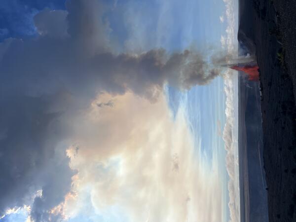
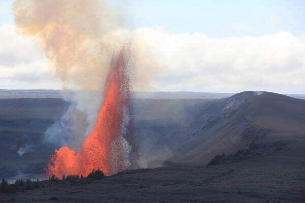
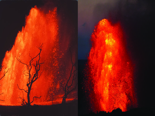
USGS Hawaiian Volcano Observatory summer 2025 interns Kamalani Poepoe (left) and Ruth Gale (right). Kamalani is pictured earlier this year on the rim of Kaluapele, the summit caldera of Kīlauea volcano, in Hawaiʻi Volcanoes National Park during one of the fountaining phases of the summit eruption in Halemaʻumaʻu.
Multimedia
Webcams—Near-real-time images from webcams.
Videos—Collection of videos recorded during field excursions or caught on our webcams.
Image Galleries—Galleries of images and events with expanded descriptions.
The Kīlauea Photo and Video Chronology and Mauna Loa Photo and Video Chronology webpages also feature photos.
Images

USGS Hawaiian Volcano Observatory summer 2025 interns Kamalani Poepoe (left) and Ruth Gale (right). Kamalani is pictured earlier this year on the rim of Kaluapele, the summit caldera of Kīlauea volcano, in Hawaiʻi Volcanoes National Park during one of the fountaining phases of the summit eruption in Halemaʻumaʻu.

The photo provides a view from near the top of the tephra deposit that accumulated during recent episodes of the ongoing eruption at Kīlauea volcano, looking west towards Kīlauea's upper Southwest Rift Zone. The brown material covering and filling in topographic lows on the landscape erupted since the eruption started on December 23, 2024.

A view of the thick deposit of tephra from the high fountaining of episode 25—along with accumulation from previous episodes—of the ongoing Kīlauea summit eruption, which blankets the crater rim southwestern rim of Halema‘uma‘u.

June 16, 2025 — Tephra collection bucket damaged during episode 25 of Kīlauea's ongoing eruptionJune
linkPhoto of a partially melted bucket with an embedded tephra clast erupted during episode 25 of the ongoing eruption at Kīlauea. Buckets are used to collect tephra, and emptied between episodes, to ensure that samples from each episode are isolated to track geochemical changes and determine the amount of tephra that fell at each site.

This reference map depicts the Kīlauea summit eruption within Halema‘uma‘u crater that began on December 23, 2024. As of this posting on June 13, the eruption continues episodically.

A cropped comparison of two USGS Hawaiian Volcano Observatory webcam images showing changes to the landscape of Kīlauea summit region over the past six months. Twenty-five episodes of lava fountaining within Halemaʻumaʻu have contributed to a growing deposit of tephra material in the closed area of Hawaiʻi Volcanoes National Park, southwest of the vents.
Videos

This timelapse video shows the lava fountaining during episode 24 of the ongoing summit eruption of Kīlauea. The main fountain, at the north vent (right), grows quickly and soon surpasses the top of the camera image, reaching over 300 meters (1000 ft) high.
This timelapse video (taken by the V3cam on the south rim of the crater) shows all of episode 23 of the ongoing Kīlauea summit eruption, which was active from 4:15 p.m. HST to 10:25 p.m. on May 25. Both the north and south vents in Halemaʻumaʻu erupted during episode 23. Lava fountains from the north vent reached heights of more than 1,000 feet (300 meters).

This video compilation shows several clips of episode 23 of the ongoing Kīlauea summit eruption, which was active from 4:15 p.m. HST to 10:25 p.m. on May 25. Both the north and south vents in Halemaʻumaʻu erupted during episode 23. Lava fountains from the north vent reached heights of more than 1,000 feet (300 meters).

This video compilation shows several clips of episode 23 of the ongoing Kīlauea summit eruption taken by the USGS Hawaiian Volcano Observatory livestream cameras. During episode 23, which was active from 4:15 p.m. HST to 10:25 p.m. on May 25, both the north and south vents in Halemaʻumaʻu erupted.

Kīlauea summit livestream camera viewers have recently observed flames within the vents in Halemaʻumaʻu. These flames, which are often a yellowish orange color, result from hydrogen gas burning in air. Hydrogen is a minor component of volcanic gas released from the hot magma below, and it can sometimes be ignited causing the flames observed recently.

May 3, 2025, bolide acoustic signal recorded by infrasound station in Yellowstone National Park
linkThis audio clip is the infrasound recorded during 1 minute on May 3, 2025, at 9:33 p.m.
May 3, 2025, bolide acoustic signal recorded by infrasound station in Yellowstone National Park
linkThis audio clip is the infrasound recorded during 1 minute on May 3, 2025, at 9:33 p.m.
Audio


Sounds of lava lake activity within Kilauea Volcano's summit vent inside Halema`uma`u Crater on the afternoon of February 14, 2011. The continuous "crashing wave" noise is the sound of churning lava as gases are released from the lake surface, which is in nearly constant motion.
Kilauea Volcano in Hawaii has experienced its first explosive eruption in more than 80 years and is now spewing noxious gas at 10 times the normal rate. John Eichelberger, head of the USGS Volcano Hazards Program, fills us in on the situation.
Webcams

Last 24 Hours - Live view of Halemaʻumaʻu crater within Kaluapele (Kīlauea caldera), from the south rim of the crater [V3cam]. This camera is a pan-tilt-zoom model and the view may change depending on activity.
Disclaimer
Last 24 Hours - Live view of Halemaʻumaʻu crater within Kaluapele (Kīlauea caldera), from the south rim of the crater [V3cam]. This camera is a pan-tilt-zoom model and the view may change depending on activity.
Disclaimer

Live view of Kaluapele (Kīlauea caldera) and Halemaʻumaʻu crater, from the northeast rim of the caldera [V2cam]. This camera is a pan-tilt-zoom model and the view may change depending on activity.
Disclaimer
Live view of Kaluapele (Kīlauea caldera) and Halemaʻumaʻu crater, from the northeast rim of the caldera [V2cam]. This camera is a pan-tilt-zoom model and the view may change depending on activity.
Disclaimer

Live view of Halemaʻumaʻu crater at the summit of Kīlauea; camera is positioned on the south rim and the view is to the west [S2cam].
Disclaimer
Live view of Halemaʻumaʻu crater at the summit of Kīlauea; camera is positioned on the south rim and the view is to the west [S2cam].
Disclaimer

This image is from a temporary research camera positioned near Maunaulu, looking northwest toward the upper East Rift Zone of Kīlauea.
Disclaimer
This image is from a temporary research camera positioned near Maunaulu, looking northwest toward the upper East Rift Zone of Kīlauea.
Disclaimer

Live image of Mauna Loa's upper and middle Southwest Rift Zone from Dandelion Cone along the middle part of the rift zone [MDLcam]. This camera is a pan-tilt-zoom model and the view may change depending on activity.
Disclaimer
Live image of Mauna Loa's upper and middle Southwest Rift Zone from Dandelion Cone along the middle part of the rift zone [MDLcam]. This camera is a pan-tilt-zoom model and the view may change depending on activity.
Disclaimer

Live image of Mauna Loa's Southwest Rift Zone from the South Point area [MSPcam]. This camera is a pan-tilt-zoom model and the view may change depending on activity.
Disclaimer
Live image of Mauna Loa's Southwest Rift Zone from the South Point area [MSPcam]. This camera is a pan-tilt-zoom model and the view may change depending on activity.
Disclaimer