



View of the Kīlauea summit eruption in Hawaiʻi Volcanoes National Park, from the south rim of the caldera. The caldera wall behind the erupting vents is approximately 210 meters (690 feet) tall.
Images
Hawaiian Volcano Observatory images of eruptive activity, field work, and more.
Filter Total Items: 4184

January 16, 2025—Kīlauea summit eruption
View of the Kīlauea summit eruption in Hawaiʻi Volcanoes National Park, from the south rim of the caldera. The caldera wall behind the erupting vents is approximately 210 meters (690 feet) tall.
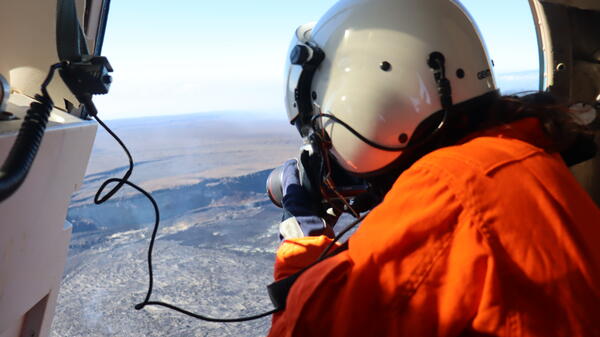
January 16, 2026 — Kīlauea summit monitoring overflight
January 16, 2026 — Kīlauea summit monitoring overflightA USGS Hawaiian Volcano Observatory geologist collects images for photogrammetric processing at the summit of Kīlauea following episode 40 lava fountaining. These surveys help determine the volume of lava erupted during each episode, and the crater infilling rates. USGS photo by T. Orr.
January 16, 2026 — Kīlauea summit monitoring overflight
January 16, 2026 — Kīlauea summit monitoring overflightA USGS Hawaiian Volcano Observatory geologist collects images for photogrammetric processing at the summit of Kīlauea following episode 40 lava fountaining. These surveys help determine the volume of lava erupted during each episode, and the crater infilling rates. USGS photo by T. Orr.

January 16, 2025—Telephoto view of Kīlauea summit eruption from Keanakākoʻi Overlook
January 16, 2025—Telephoto view of Kīlauea summit eruption from Keanakākoʻi OverlookTelephoto view of the two vents erupting in the southwest part of Halema'uma'u in Kaluapele (Kīlauea summit caldera) at approximately 6 a.m. HST on January 16, 2025. USGS Hawaiian Volcano Observatory geologists in the field this morning measured the lava fountains as reaching approximately 60 meters (197 feet) high.
January 16, 2025—Telephoto view of Kīlauea summit eruption from Keanakākoʻi Overlook
January 16, 2025—Telephoto view of Kīlauea summit eruption from Keanakākoʻi OverlookTelephoto view of the two vents erupting in the southwest part of Halema'uma'u in Kaluapele (Kīlauea summit caldera) at approximately 6 a.m. HST on January 16, 2025. USGS Hawaiian Volcano Observatory geologists in the field this morning measured the lava fountains as reaching approximately 60 meters (197 feet) high.

January 16, 2025 — Kīlauea eruption monitoring shift
January 16, 2025 — Kīlauea eruption monitoring shiftUSGS Hawaiian Volcano Observatory scientists observe the continuation of the ongoing Kīlauea eruption during its fourth eruptive episode. The eruption had been paused since January 3, 2025, and resumed on January 15, 2025.
January 16, 2025 — Kīlauea eruption monitoring shift
January 16, 2025 — Kīlauea eruption monitoring shiftUSGS Hawaiian Volcano Observatory scientists observe the continuation of the ongoing Kīlauea eruption during its fourth eruptive episode. The eruption had been paused since January 3, 2025, and resumed on January 15, 2025.
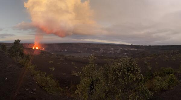
January 16, 2025—Kīlauea summit eruption from Keanakākoʻi Overlook
January 16, 2025—Kīlauea summit eruption from Keanakākoʻi OverlookPanorama view of the Kīlauea summit eruption from Keanakākoʻi Overlook in Hawaiʻi Volcanoes National Park. The Keanakākoʻi Overlook is on the south side of Kaluapele (Kīlauea summit caldera) and the view is the northwest. On the left, the two erupting vents are visible within Halemaʻumaʻu in the southwest part of Kaluapele.
January 16, 2025—Kīlauea summit eruption from Keanakākoʻi Overlook
January 16, 2025—Kīlauea summit eruption from Keanakākoʻi OverlookPanorama view of the Kīlauea summit eruption from Keanakākoʻi Overlook in Hawaiʻi Volcanoes National Park. The Keanakākoʻi Overlook is on the south side of Kaluapele (Kīlauea summit caldera) and the view is the northwest. On the left, the two erupting vents are visible within Halemaʻumaʻu in the southwest part of Kaluapele.
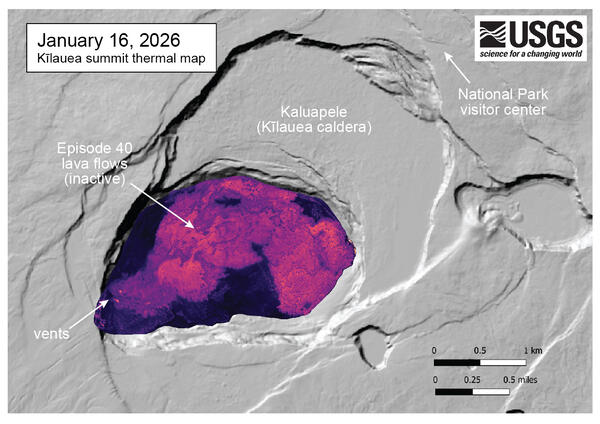
January 16, 2026 — Thermal map of Kīlauea summit after episode 40 lava fountaining
January 16, 2026 — Thermal map of Kīlauea summit after episode 40 lava fountainingThis thermal map of the summit of Kīlauea was made from images collected during a January 16 overflight, just four days after the episode 40 lava fountaining on January 12. The episode 40 lava flows from the north vent crossed much of crater floor along the north side of the crater.
January 16, 2026 — Thermal map of Kīlauea summit after episode 40 lava fountaining
January 16, 2026 — Thermal map of Kīlauea summit after episode 40 lava fountainingThis thermal map of the summit of Kīlauea was made from images collected during a January 16 overflight, just four days after the episode 40 lava fountaining on January 12. The episode 40 lava flows from the north vent crossed much of crater floor along the north side of the crater.
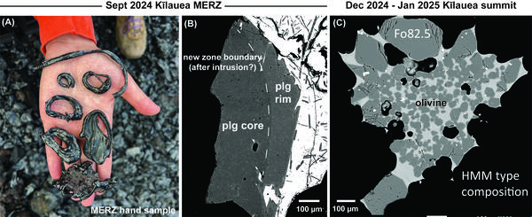
Recent Kīlauea eruption samples and crystals
(A) Spatter cone samples from the Kīlauea middle East Rift Zone eruption in and near Nāpau Crater from September 15–20, 2024. Crystals were collected from samples like this. (B) Back-scattered electron image of a plagioclase crystal from the September 2024 Kīlauea middle East Rift Zone eruption. This crystal shows two distinct chemical zones from its core to rim.
(A) Spatter cone samples from the Kīlauea middle East Rift Zone eruption in and near Nāpau Crater from September 15–20, 2024. Crystals were collected from samples like this. (B) Back-scattered electron image of a plagioclase crystal from the September 2024 Kīlauea middle East Rift Zone eruption. This crystal shows two distinct chemical zones from its core to rim.

January 16, 2025 — Kīlauea eruption monitoring shift
January 16, 2025 — Kīlauea eruption monitoring shiftDuring the reactivation of the Kīlauea summit eruption, USGS Hawaiian Volcano Observatory scientists setup high resolution cameras to record eruption dynamics. While on field shifts, scientists measure fountain and cone heights, take thermal and observational images, and collect samples for monitoring purposes.
January 16, 2025 — Kīlauea eruption monitoring shift
January 16, 2025 — Kīlauea eruption monitoring shiftDuring the reactivation of the Kīlauea summit eruption, USGS Hawaiian Volcano Observatory scientists setup high resolution cameras to record eruption dynamics. While on field shifts, scientists measure fountain and cone heights, take thermal and observational images, and collect samples for monitoring purposes.

January 15, 2025—Kīlauea summit eruption reference map
January 15, 2025—Kīlauea summit eruption reference mapThis reference map depicts the ongoing Kīlauea summit eruption within Halema‘uma‘u crater as of January 15, 2025. Most of the included map data were collected during a Hawaiian Volcano Observatory helicopter overflight on January 10, so the provided eruption statistics are current as of the end of the third eruptive episode on January 3.
January 15, 2025—Kīlauea summit eruption reference map
January 15, 2025—Kīlauea summit eruption reference mapThis reference map depicts the ongoing Kīlauea summit eruption within Halema‘uma‘u crater as of January 15, 2025. Most of the included map data were collected during a Hawaiian Volcano Observatory helicopter overflight on January 10, so the provided eruption statistics are current as of the end of the third eruptive episode on January 3.
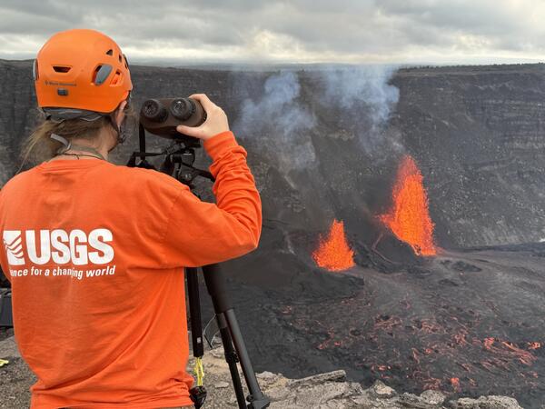
January 15, 2025—HVO scientists monitor episode 4 of Kīlauea summit eruption
January 15, 2025—HVO scientists monitor episode 4 of Kīlauea summit eruptionUSGS Hawaiian Volcano Observatory scientists monitor episode 4 of the Kīlauea summit eruption that began this morning, January 15, 2025. USGS photo by M. Patrick.
January 15, 2025—HVO scientists monitor episode 4 of Kīlauea summit eruption
January 15, 2025—HVO scientists monitor episode 4 of Kīlauea summit eruptionUSGS Hawaiian Volcano Observatory scientists monitor episode 4 of the Kīlauea summit eruption that began this morning, January 15, 2025. USGS photo by M. Patrick.
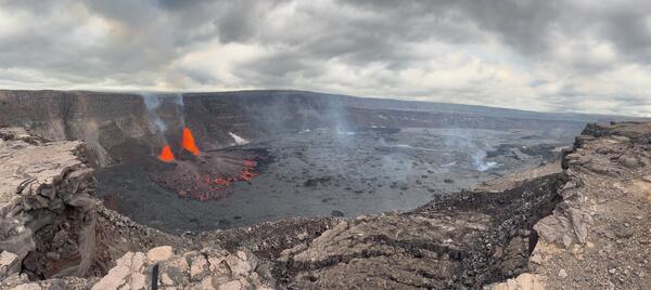
January 15, 2025—Panoramic image of Kīlauea summit eruption
January 15, 2025—Panoramic image of Kīlauea summit eruptionPanorama image of the north and south vents in the west portion of Kīlauea caldera are erupting lava fountains during the afternoon of January 15, 2025. Lava fountains are feeding lava flows that are moving in an eastward direction on the caldera floor. USGS photo by M. Patrick.
January 15, 2025—Panoramic image of Kīlauea summit eruption
January 15, 2025—Panoramic image of Kīlauea summit eruptionPanorama image of the north and south vents in the west portion of Kīlauea caldera are erupting lava fountains during the afternoon of January 15, 2025. Lava fountains are feeding lava flows that are moving in an eastward direction on the caldera floor. USGS photo by M. Patrick.

January 15, 2025—HVO scientists check volcano monitoring equipment
January 15, 2025—HVO scientists check volcano monitoring equipmentUSGS Hawaiian Volcano Observatory scientists check volcanic gas monitoring equipment located downwind of the erupting vents in Kaluapele, Kīlauea summit caldera. The light-brown eruptive plume from episode 4 of the eruption is visible in the background of the image. USGS photo by B. Lopez.
January 15, 2025—HVO scientists check volcano monitoring equipment
January 15, 2025—HVO scientists check volcano monitoring equipmentUSGS Hawaiian Volcano Observatory scientists check volcanic gas monitoring equipment located downwind of the erupting vents in Kaluapele, Kīlauea summit caldera. The light-brown eruptive plume from episode 4 of the eruption is visible in the background of the image. USGS photo by B. Lopez.
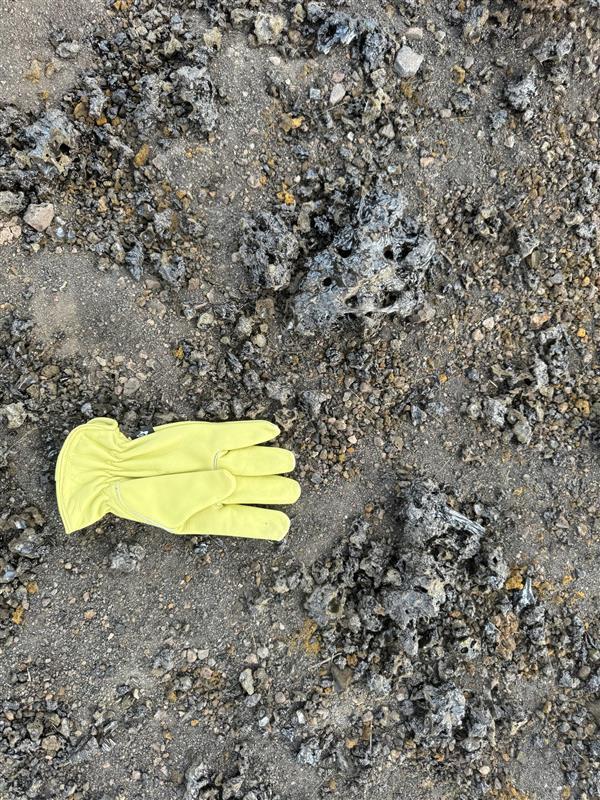
January 15, 2025—Episode 4 of Kīlauea summit eruption
January 15, 2025—Episode 4 of Kīlauea summit eruptionAround 9:15 a.m. HST this morning, January 15, 2025, the eruption of Kīlauea within Kaluapele (summit caldera) resumed with a small lava flow exiting the north vent. Later in the morning, more vigorous lava fountaining began, which deposited tephra material on the west rim of the caldera in the closed area of Hawaiʻi Volcanoes National Park.
January 15, 2025—Episode 4 of Kīlauea summit eruption
January 15, 2025—Episode 4 of Kīlauea summit eruptionAround 9:15 a.m. HST this morning, January 15, 2025, the eruption of Kīlauea within Kaluapele (summit caldera) resumed with a small lava flow exiting the north vent. Later in the morning, more vigorous lava fountaining began, which deposited tephra material on the west rim of the caldera in the closed area of Hawaiʻi Volcanoes National Park.

January 15, 2025—Episode 4 of Kīlauea summit eruption
January 15, 2025—Episode 4 of Kīlauea summit eruptionEpisode 4 of the ongoing Kīlauea summit eruption began this morning, January 15, 2025. Lava fountains resumed erupting from the two vents that have been active in the eruption that began within Halemaʻumaʻu at the summit of Kīlauea volcano on December 23, 2024.
January 15, 2025—Episode 4 of Kīlauea summit eruption
January 15, 2025—Episode 4 of Kīlauea summit eruptionEpisode 4 of the ongoing Kīlauea summit eruption began this morning, January 15, 2025. Lava fountains resumed erupting from the two vents that have been active in the eruption that began within Halemaʻumaʻu at the summit of Kīlauea volcano on December 23, 2024.
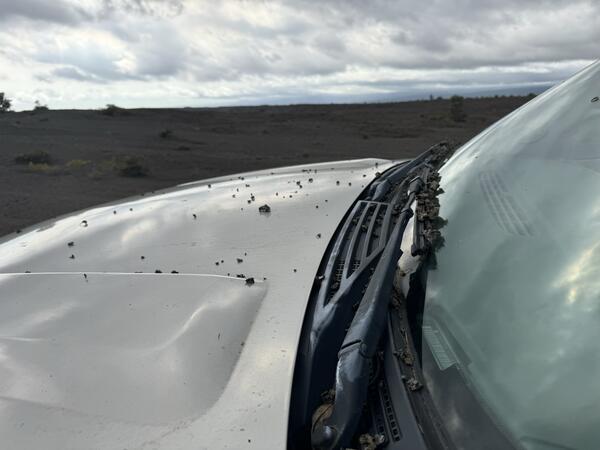
January 15, 2025—Kīlauea summit eruption tephra on vehicle
January 15, 2025—Kīlauea summit eruption tephra on vehicleUSGS Hawaiian Volcano Observatory scientists collected samples of episode 4 of the ongoing Kīlauea summit eruption, which began the morning of January 15, 2025. The samples were collected from the west rim of Kaluapele, Kīlauea summit caldera.
January 15, 2025—Kīlauea summit eruption tephra on vehicle
January 15, 2025—Kīlauea summit eruption tephra on vehicleUSGS Hawaiian Volcano Observatory scientists collected samples of episode 4 of the ongoing Kīlauea summit eruption, which began the morning of January 15, 2025. The samples were collected from the west rim of Kaluapele, Kīlauea summit caldera.

January 10, 2025 — Kīlauea overflight
An aerial view of both eruptive vents from the December 2024 to January 2025 eruption in Kīlauea's summit. This photo is looking down with the south vent on the left and the north vent on the right. The south vent has been the most active during the eruption and produced fountains up to 90 meters (about 300 feet) during its opening phase.
An aerial view of both eruptive vents from the December 2024 to January 2025 eruption in Kīlauea's summit. This photo is looking down with the south vent on the left and the north vent on the right. The south vent has been the most active during the eruption and produced fountains up to 90 meters (about 300 feet) during its opening phase.

January 10, 2025 — Puhimau thermal area, Kīlauea
This aerial photo, looking southeast from Kīlauea summit down Chain of Craters Road within Hawai‘i Volcanoes National Park, shows a lava flow from 1974 (bottom left and right) along with Puhimau Crater (center left).
This aerial photo, looking southeast from Kīlauea summit down Chain of Craters Road within Hawai‘i Volcanoes National Park, shows a lava flow from 1974 (bottom left and right) along with Puhimau Crater (center left).

January 10, 2025 — Kīlauea overflight
This aerial view shows the two eruptive cones from the December 2024 to January 2025 paused eruption at Kīlauea's summit. The eruption paused on Jan 3, 2025, but geologists observed active lava within the vents during the monitoring overflight. This photo is looking southwest with the southwest flank of Mauna Loa in the background. USGS photo by H. Winslow.
This aerial view shows the two eruptive cones from the December 2024 to January 2025 paused eruption at Kīlauea's summit. The eruption paused on Jan 3, 2025, but geologists observed active lava within the vents during the monitoring overflight. This photo is looking southwest with the southwest flank of Mauna Loa in the background. USGS photo by H. Winslow.
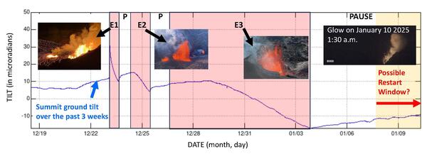
Ground tilt and eruptive episodes associated with Kīlauea summit eruption December 23, 2024, to January 10, 2025
Ground tilt and eruptive episodes associated with Kīlauea summit eruption December 23, 2024, to January 10, 2025Ground tilt and eruptive episodes associated with Kīlauea summit eruption December 23, 2024, to January 10, 2025. Eruptive episodes are highlighted in red. Fountain Episode 1 (E1) began at 2:20 a.m. HST on December 23, 2024, and continued until 4 p.m. that day (14 hours duration). Fountain Episode 2 (E2) began at 8 a.m.
Ground tilt and eruptive episodes associated with Kīlauea summit eruption December 23, 2024, to January 10, 2025
Ground tilt and eruptive episodes associated with Kīlauea summit eruption December 23, 2024, to January 10, 2025Ground tilt and eruptive episodes associated with Kīlauea summit eruption December 23, 2024, to January 10, 2025. Eruptive episodes are highlighted in red. Fountain Episode 1 (E1) began at 2:20 a.m. HST on December 23, 2024, and continued until 4 p.m. that day (14 hours duration). Fountain Episode 2 (E2) began at 8 a.m.

January 10, 2025 — Kīlauea Iki
An aerial view of Kīlauea Iki and Pu‘u Pua‘i taken during an overflight of Kīlauea summit on January 10, 2025. Pu‘u Pua‘i, the large cinder cone in the lower right of the image, was formed by lava fountains that reached 580 meters (1,900 ft) during the 1959 Kīlauea IKI eruption. The popular Kīlauea Iki hiking trail is visible across the crater floor.
An aerial view of Kīlauea Iki and Pu‘u Pua‘i taken during an overflight of Kīlauea summit on January 10, 2025. Pu‘u Pua‘i, the large cinder cone in the lower right of the image, was formed by lava fountains that reached 580 meters (1,900 ft) during the 1959 Kīlauea IKI eruption. The popular Kīlauea Iki hiking trail is visible across the crater floor.

January 10, 2025 — Kīlauea GPS station
On January 10, 2025, USGS Hawaiian Volcano Observatory scientists (HVO) collected data from two semi-permanent GPS sites on Kīlauea's caldera floor. GPS stations record changes in elevation on the caldera floor and can track ground deformation changes that HVO uses for monitoring unrest.
On January 10, 2025, USGS Hawaiian Volcano Observatory scientists (HVO) collected data from two semi-permanent GPS sites on Kīlauea's caldera floor. GPS stations record changes in elevation on the caldera floor and can track ground deformation changes that HVO uses for monitoring unrest.