U.S. flag

An official website of the United States government

Images

Volcano Hazard Program images.

Filter Total Items: 6266
Satellite image of area around flow front...
Image of area around flow front

This map uses a satellite image acquired in March 2014 (provided by Digital Globe) as a base to show the area around the front of the June 27th lava flow. The area of the flow on October 10, 2014, at 10:30 AM is shown in pink, while widening and advancement of the flow as mapped on October 13 at 9:30 AM is shown in red.

This map uses a satellite image acquired in March 2014 (provided by Digital Globe) as a base to show the area around the front of the June 27th lava flow. The area of the flow on October 10, 2014, at 10:30 AM is shown in pink, while widening and advancement of the flow as mapped on October 13 at 9:30 AM is shown in red.

June 27th lava flow remains active, continues advancing northeast...
June 27th lava flow remains active, continues advancing NE

The flow front remains active, with continued slow advancement towards the northeast over the weekend. The flow front today was 1.1 km (0.7 miles) upslope from Apa‘a St. and 2.2 km (1.4 miles) from Pāhoa Village Road, as measured along a straight line.

The flow front remains active, with continued slow advancement towards the northeast over the weekend. The flow front today was 1.1 km (0.7 miles) upslope from Apa‘a St. and 2.2 km (1.4 miles) from Pāhoa Village Road, as measured along a straight line.

A view of the flow front from a normal camera (left) as well as fro...
flow front from a normal camera as well as from a thermal camera (r...

A view of the flow front from a normal camera (left) as well as from a thermal camera (right). The white box shows the extent of the thermal image. The thermal image shows that breakouts are active at the leading tip of the flow, and are also scattered upslope from the flow front.

A view of the flow front from a normal camera (left) as well as from a thermal camera (right). The white box shows the extent of the thermal image. The thermal image shows that breakouts are active at the leading tip of the flow, and are also scattered upslope from the flow front.

A wider view of the flow front, looking upslope. Kaohe Homesteads ...
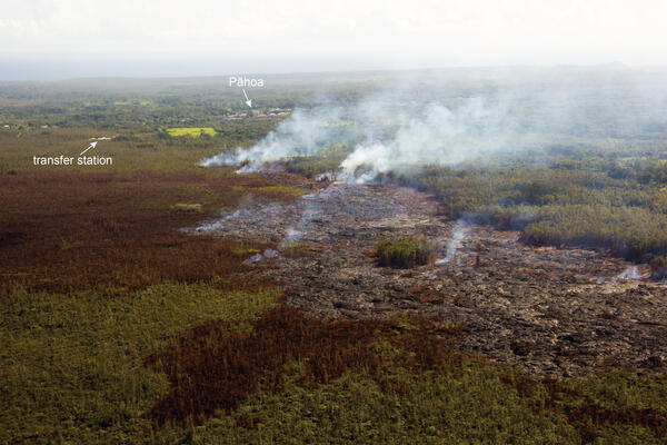
flow front, looking upslope. Kaohe Homesteads is in the left porti...

A wider view of the flow front, looking upslope. Kaohe Homesteads is in the left portion of the image, and Pu‘u ‘Ō‘ō can be seen on the horizon.

Comparison of a normal photograph with a thermal image. The white ...
Comparison of a normal photograph with a thermal image

Comparison of a normal photograph with a thermal image. The white box shows the rough extent of the thermal image. The thermal image shows active breakouts (white and yellow areas) focused at the flow front but also scattered behind the front.

Comparison of a normal photograph with a thermal image. The white box shows the rough extent of the thermal image. The thermal image shows active breakouts (white and yellow areas) focused at the flow front but also scattered behind the front.

Flow front remains narrow, continues to advance towards northeast...
Flow front remains narrow, continues to advance towards NE

The June 27th lava flow remains active, and continues advancing towards the northeast. The flow front today was still narrow, about 185 m (roughly 600 feet) wide. The flow front today was 1.3 km (0.8 miles) upslope from Apa‘a St. and 2.4 km (1.5 miles) from Pāhoa Village Road.

The June 27th lava flow remains active, and continues advancing towards the northeast. The flow front today was still narrow, about 185 m (roughly 600 feet) wide. The flow front today was 1.3 km (0.8 miles) upslope from Apa‘a St. and 2.4 km (1.5 miles) from Pāhoa Village Road.

A closer look at the narrow flow front. Kaohe Homesteads subdivisi...
narrow flow front. Kaohe Homesteads subdivision in the upper left ...
Satellite image of area around flow front...
Image of area around flow front

This map uses a satellite image acquired in March 2014 (provided by Digital Globe) as a base to show the area around the front of the June 27th lava flow. The area of the flow on October 8, 2014, at 10:20 AM is shown in pink, while widening and advancement of the flow as mapped on October 10 at 10:30 AM is shown in red.

This map uses a satellite image acquired in March 2014 (provided by Digital Globe) as a base to show the area around the front of the June 27th lava flow. The area of the flow on October 8, 2014, at 10:20 AM is shown in pink, while widening and advancement of the flow as mapped on October 10 at 10:30 AM is shown in red.

Small-scale map of June 27th flow in Kīlauea's East Rift Zone...
Small-scale map of June 27th flow in Kīlauea's ERZ

This small-scale map shows the June 27th lava flow in Kīlauea's East Rift Zone in relation to lower Puna. The area of the flow on October 8, 2014, at 10:20 AM is shown in pink, while widening and advancement of the flow as mapped on October 10 at 10:30 AM is shown in red.

This small-scale map shows the June 27th lava flow in Kīlauea's East Rift Zone in relation to lower Puna. The area of the flow on October 8, 2014, at 10:20 AM is shown in pink, while widening and advancement of the flow as mapped on October 10 at 10:30 AM is shown in red.

Large-scale map of June 27th flow in Kīlauea's East Rift Zone...
Large-scale map of June 27th flow in Kīlauea's ERZ

This large-scale map shows the distal part of the June 27th flow in relation to nearby Puna communities. The area of the flow on October 8, 2014, at 10:20 AM is shown in pink, while widening and advancement of the flow as mapped on October 10 at 10:30 AM is shown in red.

This large-scale map shows the distal part of the June 27th flow in relation to nearby Puna communities. The area of the flow on October 8, 2014, at 10:20 AM is shown in pink, while widening and advancement of the flow as mapped on October 10 at 10:30 AM is shown in red.

Preview image for video: provides a brief aerial overview of the fl...
provides a brief aerial overview of the flow front, showing its pro...

Preview image for video: provides a brief aerial overview of the flow front, showing its proximity to the the transfer station on Apa‘a St., and ends by panning over to show Pāhoa.

USGS scientist waits for helicopter pick-up in the crater of Mount ...
USGS scientist waits for helicopter pick-up in Mount St. Helens crater

USGS-CVO Research Geologist Peter Kelly communicates with the helicopter pilot and prepares for pick-up, on the new dome within the crater of Mount St. Helens.

Large-scale map of June 27th flow in Kīlauea's East Rift Zone...
Large-scale map of June 27th flow in Kīlauea's ERZ

This large-scale map shows the distal part of the June 27th flow in relation to nearby Puna communities. The area of the flow on October 6 at 12:15 PM is shown in pink, while advancement of the flow as mapped on October 8 at 10:20 AM is shown in red. Breakouts were mainly scattered across the leading edge of the flow.

This large-scale map shows the distal part of the June 27th flow in relation to nearby Puna communities. The area of the flow on October 6 at 12:15 PM is shown in pink, while advancement of the flow as mapped on October 8 at 10:20 AM is shown in red. Breakouts were mainly scattered across the leading edge of the flow.

A look into the southern portion of Pu‘u ‘Ō‘ō Crater. A small lava...
southern portion of Pu‘u ‘Ō‘ō.

A look into the southern portion of Pu‘u ‘Ō‘ō Crater. A small lava pond (roughly 10 meters, or yards, wide) was active in the southern pit. The pond surface was fluctuating as spattering was active on the pond margin.

A look into the southern portion of Pu‘u ‘Ō‘ō Crater. A small lava pond (roughly 10 meters, or yards, wide) was active in the southern pit. The pond surface was fluctuating as spattering was active on the pond margin.

Satellite image of area around flow front...
Image of area around flow front

This map uses a satellite image acquired in March 2014 (provided by Digital Globe) as a base to show the area around the front of the June 27th lava flow. The area of the flow on October 6, 2014, at 12:15 AM is shown in pink, while widening and advancement of the flow as mapped on October 8 at 10:20 PM is shown in red.

This map uses a satellite image acquired in March 2014 (provided by Digital Globe) as a base to show the area around the front of the June 27th lava flow. The area of the flow on October 6, 2014, at 12:15 AM is shown in pink, while widening and advancement of the flow as mapped on October 8 at 10:20 PM is shown in red.

Flow front remains narrow, and continues slowly advancing to northe...
Flow front remains narrow, and continues slowly advancing to NE

The June 27th lava flow remains active, and continues to slowly advance towards the northeast along the forest boundary. The flow front remains narrow, about 100 m (yards) wide, and was 1.4 km (0.9 miles) from Apa‘a St. and 2.5 km (1.6 miles) from Pāhoa Village Road (as measured along a straight line).

The June 27th lava flow remains active, and continues to slowly advance towards the northeast along the forest boundary. The flow front remains narrow, about 100 m (yards) wide, and was 1.4 km (0.9 miles) from Apa‘a St. and 2.5 km (1.6 miles) from Pāhoa Village Road (as measured along a straight line).

A wider view of the flow front, with Kaohe Homesteads at the left s...
flow front, with Kaohe Homesteads at the left side of the photograp...

A wider view of the flow front, with Kaohe Homesteads at the left side of the photograph. Pu‘u ‘Ō‘ō can be seen on the horizon in the upper right.

A normal photograph compared with a thermal image of the flow front...
A normal photograph compared with a thermal image of the flow front

A normal photograph compared with a thermal image of the flow front. The white box shows the approximate extent of the thermal image. Breakouts (white and yellow areas in thermal image) were active at the leading edge of the flow, and were also scattered behind the flow front.

A normal photograph compared with a thermal image of the flow front. The white box shows the approximate extent of the thermal image. Breakouts (white and yellow areas in thermal image) were active at the leading edge of the flow, and were also scattered behind the flow front.

Preview image for video: provides a quick aerial overview of activi...
provides a quick aerial overview of activity at the flow front. At...

Preview image for video: provides a quick aerial overview of activity at the flow front. At the end of the movie there is a view of the lava stream in one of the skylights on the lava tube supplying lava to the flow front.

Preview image for video: provides a quick aerial overview of activity at the flow front. At the end of the movie there is a view of the lava stream in one of the skylights on the lava tube supplying lava to the flow front.

Small-scale map of June 27th flow in Kīlauea's East Rift Zone...
Small-scale map of June 27th flow in Kīlauea's ERZ

This small-scale map shows the June 27th lava flow in Kīlauea's East Rift Zone in relation to lower Puna. The area of the flow on October 6, 2014, at 12:15 PM is shown in pink, while advancement of the flow as mapped on October 8 at 10:20 AM is shown in red. The latitude and longitude of the flow front at that time was 19.48107, -154.96857 (Decimal degrees; WGS84).

This small-scale map shows the June 27th lava flow in Kīlauea's East Rift Zone in relation to lower Puna. The area of the flow on October 6, 2014, at 12:15 PM is shown in pink, while advancement of the flow as mapped on October 8 at 10:20 AM is shown in red. The latitude and longitude of the flow front at that time was 19.48107, -154.96857 (Decimal degrees; WGS84).

A closer view of the flow front moving along the forest boundary. ...
flow front moving along the forest boundary. The flow front had ne...

A closer view of the flow front moving along the forest boundary. The flow front had nearly entered a clearing in the thick forest.

Was this page helpful?