
Mount St. Helens, as viewed from the East-Northeast. The inside of the crater rim is just visible in the upper right of the mountain.
Images
Volcano Hazard Program images.
Filter Total Items: 6274

Mount St. Helens as viewed from the ENE.
Mount St. Helens, as viewed from the East-Northeast. The inside of the crater rim is just visible in the upper right of the mountain.


Did aerial bombing stop the 1935 Mauna Loa lava flow?
Did aerial bombing stop the 1935 Mauna Loa lava flow?Aerial view of a bomb detonating on Mauna Loa near the 8500-foot elevation source of the 1935 lava flow on the morning of December 27, 1935. This was one of twenty 600-pound bombs dropped on the lava flow that morning by the Army Bombing Squadron from Luke Field, O‘ahu. Photo by Army Air Corps, 11th Photo Section.

What do we call new land at Kīlauea's ocean entries?
What do we call new land at Kīlauea's ocean entries?Kīlauea Volcano's Kamokuna lava delta on October 6, 2017. Multiple streams of lava entering the ocean on both sides of the delta created small plumes of laze (lava haze). The visible part of the delta, which is deceptively stable, was built by many small lava flows accumulating on an unstable foundation of unconsolidated volcanic rock fragments. USGS photo by L.

Typical lava lake activity at Kīlauea's summit
Kīlauea Volcano's summit lava lake activity over the past few days has been typical, with intermittent sites of spattering and migration of the crust from north to south (top to bottom of image). This view of the lava lake was captured on the evening of Saturday, November 18.
Kīlauea Volcano's summit lava lake activity over the past few days has been typical, with intermittent sites of spattering and migration of the crust from north to south (top to bottom of image). This view of the lava lake was captured on the evening of Saturday, November 18.

typical spattering in the summit lava lake in Halema‘uma‘u
typical spattering in the summit lava lake in Halema‘uma‘uThis video shows typical spattering in the summit lava lake in Halema‘uma‘u Crater. Spattering is driven by the bursting of large gas bubbles. The surface crust tends to flow into the spattering sites, where the crust is shredded and sinks.

Spattering is common in the summit lava lake, normally at one or mo...
Spattering is common in the summit lava lake, normally at one or mo...Spattering is common in the summit lava lake, normally at one or more sites along the lake margin. A spattering area along the northeast lake margin on Friday, November 17, is shown here. The surface crust tends to flow into the spattering area, where it sinks.

The surface crust on the summit lava lake has many different textur...
The surface crust on the summit lava lake has many different textur...The surface crust on the summit lava lake has many different textures, and these textures can be used to identify where portions of a crustal plate originated. For instance, in this November 20 photo, the long narrow band of striated crust that cuts across the image diagonally originated from the spreading zone in the upper left area of the photo.

Weak flows on Kamokuna delta
Over the past week, the episode 61g Kamokuna lava delta has been partially resurfaced by viscous, spiny pāhoehoe flows (darker in color). Geologists at the ocean entry today (November 17) did not see an active ocean entry, but lava has intermittently entered the ocean over the past few weeks.
Over the past week, the episode 61g Kamokuna lava delta has been partially resurfaced by viscous, spiny pāhoehoe flows (darker in color). Geologists at the ocean entry today (November 17) did not see an active ocean entry, but lava has intermittently entered the ocean over the past few weeks.

Drive along Saddle Road reveals outstanding volcanic geology
Drive along Saddle Road reveals outstanding volcanic geologyTwo nene fly above Pu‘uhuluhulu, a forested Mauna Kea cinder cone surrounded by younger Mauna Loa lava flows (foreground), in the Humu‘ula Saddle on the Island of Hawai‘i. This cone is just one of the outstanding volcanic features that can be seen along Route 200, the Daniel K. Inouye Highway. USGS photo by J. Kauahikaua.

Moku‘āweoweo's North Pit, looking to the west-southwest
Moku‘āweoweo's North Pit, looking to the west-southwestView of Moku‘āweoweo's North Pit, looking to the west-southwest. The summit of Mauna Loa is the peak visible in the background, slightly left of center. The two linear features in the foreground are ramparts from previous fissure eruptions.

Leading a FEMA training course near Lassen Volcanic National Park
Leading a FEMA training course near Lassen Volcanic National ParkUSGS volcanologist Jessica Ball leads a discussion during a FEMA Volcanic Crisis Awareness course held in Chester, CA in November 2017.
Leading a FEMA training course near Lassen Volcanic National Park
Leading a FEMA training course near Lassen Volcanic National ParkUSGS volcanologist Jessica Ball leads a discussion during a FEMA Volcanic Crisis Awareness course held in Chester, CA in November 2017.

Threat Rankings of our Nation's geologically young volcanoes
Threat Rankings of our Nation's geologically young volcanoesHualālai (center) and Mauna Loa (left background), two of the four active volcanoes on the Island of Hawai‘i, are ranked as "high threat" and "very high threat" volcanoes, respectively. Kīholo Bay (left foreground) is flanked on the north (left) by a lava flow erupted from Mauna Loa in 1859 and on the south by the Ka‘ūPULEHU flow erupted from Hualālai around 1800.

USGS maps identify lava inundation zones for Mauna Loa
USGS maps identify lava inundation zones for Mauna LoaClose up of Sheet 2 of "Lava inundation zone maps for Mauna Loa, Island of Hawai‘i," recently published by the U.S. Geological Survey. Colors depict lava Inundation zones for the Kaumana, Waiākea, and Volcano-Mountain View regions on Mauna Loa. Yellow indicates the volcano's Northeast Rift Zone, one area along which lava could erupt.

Mount Adams viewed from SE.
Mount Adams viewed from the southeast.
Mount Adams viewed from the southeast.

New USGS video about Kīlauea's summit eruption is now online
New USGS video about Kīlauea's summit eruption is now onlineThe lava lake within Halema‘uma‘u, a crater at the summit of Kīlauea, was about 30 m (98 ft) below the vent rim on the day of this photo (January 7, 2016).
New USGS video about Kīlauea's summit eruption is now online
New USGS video about Kīlauea's summit eruption is now onlineThe lava lake within Halema‘uma‘u, a crater at the summit of Kīlauea, was about 30 m (98 ft) below the vent rim on the day of this photo (January 7, 2016).

View of the Silver Gate landslide complex from Bunsen Peak
View of the Silver Gate landslide complex from Bunsen PeakView of the Silver Gate landslide complex from Bunsen Peak in Yellowstone National Park. The landslide originates from Terrace Mountain.
View of the Silver Gate landslide complex from Bunsen Peak
View of the Silver Gate landslide complex from Bunsen PeakView of the Silver Gate landslide complex from Bunsen Peak in Yellowstone National Park. The landslide originates from Terrace Mountain.
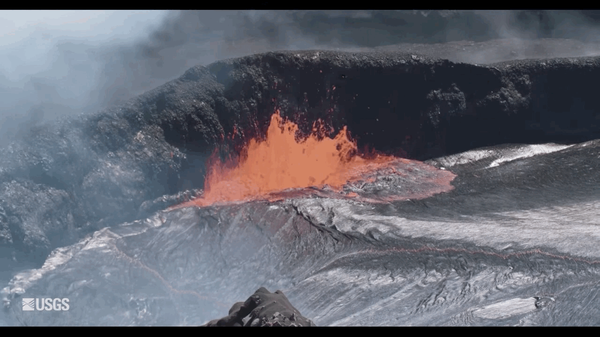
Lava Bubbling in Kīlauea Hawaiʻi
Animated GIF of lava bubbling up from Kīlauea Volcano in Hawaiʻi Volcanoes National Park. The source of the GIF comes from footage found within the USGS video: Kīlauea Summit Eruption | Lava Returns to Halemaʻumaʻu.
Animated GIF of lava bubbling up from Kīlauea Volcano in Hawaiʻi Volcanoes National Park. The source of the GIF comes from footage found within the USGS video: Kīlauea Summit Eruption | Lava Returns to Halemaʻumaʻu.
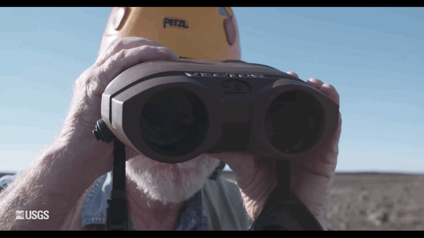
Looking Back and Forth
Animated GIF of a scientist at Kīlauea Volcano in Hawaiʻi Volcanoes National Park looking back and forth using a range finder. Footage found in the USGS video: Kīlauea Summit Eruption | Lava Returns to Halemaʻumaʻu.
Animated GIF of a scientist at Kīlauea Volcano in Hawaiʻi Volcanoes National Park looking back and forth using a range finder. Footage found in the USGS video: Kīlauea Summit Eruption | Lava Returns to Halemaʻumaʻu.

pāhoehoe breakouts on the coastal plain
Scattered breakouts today (October 13) on the western 61g flow margin were mapped at 1.3 km (0.8 mi) from the closest portion of the emergency road. The small pāhoehoe breakouts put on a show as they slowly oozed out of growing cracks that were forced open by flow inflation (pictured).
Scattered breakouts today (October 13) on the western 61g flow margin were mapped at 1.3 km (0.8 mi) from the closest portion of the emergency road. The small pāhoehoe breakouts put on a show as they slowly oozed out of growing cracks that were forced open by flow inflation (pictured).

Map of flow field
This map shows recent changes to Kīlauea's East Rift Zone lava flow field. The area of the active flow field as of September 21 is shown in pink, while widening and advancement of the active flow as of October 12 is shown in red. Older Pu‘u ‘Ō‘ō lava flows (1983-2016) are shown in gray. The yellow line is the trace of the active lava tube.
This map shows recent changes to Kīlauea's East Rift Zone lava flow field. The area of the active flow field as of September 21 is shown in pink, while widening and advancement of the active flow as of October 12 is shown in red. Older Pu‘u ‘Ō‘ō lava flows (1983-2016) are shown in gray. The yellow line is the trace of the active lava tube.