



An open lava stream continues to pour out of the lava tube, perched high on the sea cliff, and into the ocean. The stream was remarkably steady today, but produced pulsating littoral explosions that threw spatter onto the sea cliff.
Images
Volcano Hazard Program images.
Filter Total Items: 6279

Open lava stream continues at ocean entry
An open lava stream continues to pour out of the lava tube, perched high on the sea cliff, and into the ocean. The stream was remarkably steady today, but produced pulsating littoral explosions that threw spatter onto the sea cliff.

base of the lava stream, where ripples in the narrow sheet of lava ...
base of the lava stream, where ripples in the narrow sheet of lava ...This video shows a close-up of the base of the lava stream, where ripples in the narrow sheet of lava are visible.
base of the lava stream, where ripples in the narrow sheet of lava ...
base of the lava stream, where ripples in the narrow sheet of lava ...This video shows a close-up of the base of the lava stream, where ripples in the narrow sheet of lava are visible.

ocean entry.
A wider view of the ocean entry.
A wider view of the ocean entry.

Near the base of the lava stream, just above where it impacted the ...
Near the base of the lava stream, just above where it impacted the ...Near the base of the lava stream, just above where it impacted the water, there were commonly ripples in the stream, suggesting this was a narrow sheet of lava. These ripples can be seen on the lower right side of the lava stream. A few small, steaming clasts thrown up by a small littoral explosion are visible in front of the stream.
Near the base of the lava stream, just above where it impacted the ...
Near the base of the lava stream, just above where it impacted the ...Near the base of the lava stream, just above where it impacted the water, there were commonly ripples in the stream, suggesting this was a narrow sheet of lava. These ripples can be seen on the lower right side of the lava stream. A few small, steaming clasts thrown up by a small littoral explosion are visible in front of the stream.

open lava stream at the ocean entry, and the frequent littoral expl...
open lava stream at the ocean entry, and the frequent littoral expl...This video shows a wider view of the open lava stream at the ocean entry, and the frequent littoral explosions.
open lava stream at the ocean entry, and the frequent littoral expl...
open lava stream at the ocean entry, and the frequent littoral expl...This video shows a wider view of the open lava stream at the ocean entry, and the frequent littoral explosions.

A close up of the stream near spot where it exits the tube. This v...
A close up of the stream near spot where it exits the tube. This v...A close up of the stream near the spot where it exits the tube. This view was only possible with a very high magnification lens.
A close up of the stream near spot where it exits the tube. This v...
A close up of the stream near spot where it exits the tube. This v...A close up of the stream near the spot where it exits the tube. This view was only possible with a very high magnification lens.

HVO geophysicist shares information at a public outreach event for ...
HVO geophysicist shares information at a public outreach event for ...HVO geophysicist shares information at a public outreach event for Volcano Awareness Month at the University of Hawai‘i at Hilo in January 2017.
HVO geophysicist shares information at a public outreach event for ...
HVO geophysicist shares information at a public outreach event for ...HVO geophysicist shares information at a public outreach event for Volcano Awareness Month at the University of Hawai‘i at Hilo in January 2017.

Exploring USGS volcano observatories—Part 4: Yellowstone
Exploring USGS volcano observatories—Part 4: YellowstoneYellowstone National Park is the site of Earth's largest concentration of geysers, as well as steam vents, hot springs, and mudpots. These hydrothermal features attest to the region's volcanic history, which spans over two million years and is the reason that the Yellowstone Volcano Observatory was established.
Exploring USGS volcano observatories—Part 4: Yellowstone
Exploring USGS volcano observatories—Part 4: YellowstoneYellowstone National Park is the site of Earth's largest concentration of geysers, as well as steam vents, hot springs, and mudpots. These hydrothermal features attest to the region's volcanic history, which spans over two million years and is the reason that the Yellowstone Volcano Observatory was established.

Lava continues to stream out of tube at Kamokuna ocean entry
Lava continues to stream out of tube at Kamokuna ocean entryA steady stream of lava exiting the episode 61g lava tube pours into the ocean at the Kamokuna ocean entry. The interaction between the lava and ocean water causes explosive reactions, throwing bits of lava (seen in the photo at the base of the lava stream).
Lava continues to stream out of tube at Kamokuna ocean entry
Lava continues to stream out of tube at Kamokuna ocean entryA steady stream of lava exiting the episode 61g lava tube pours into the ocean at the Kamokuna ocean entry. The interaction between the lava and ocean water causes explosive reactions, throwing bits of lava (seen in the photo at the base of the lava stream).

Misty weather created a double rainbow over Pūlama Pali and the 61g...
Misty weather created a double rainbow over Pūlama Pali and the 61g...Misty weather created a double rainbow over Pūlama Pali and the 61g flow field. Fume trace from the tube can be seen at bottom center.
Misty weather created a double rainbow over Pūlama Pali and the 61g...
Misty weather created a double rainbow over Pūlama Pali and the 61g...Misty weather created a double rainbow over Pūlama Pali and the 61g flow field. Fume trace from the tube can be seen at bottom center.

the lava stream pouring out of the tube into Pacific Ocean
the lava stream pouring out of the tube into Pacific OceanThis video clip shows the lava stream - about 1-2 m or yards wide - pouring out of the tube into the Pacific Ocean, triggering pulsating explosions that are throwing bits of lava onto the top of the sea cliff.
the lava stream pouring out of the tube into Pacific Ocean
the lava stream pouring out of the tube into Pacific OceanThis video clip shows the lava stream - about 1-2 m or yards wide - pouring out of the tube into the Pacific Ocean, triggering pulsating explosions that are throwing bits of lava onto the top of the sea cliff.

Kamokuna ocean entry
This thermal image shows the Kamokuna ocean entry. Two plumes of hot (scalding) water branch out from the entry point. The lava stream itself is the very hot feature right of center. Just above the lava stream, about 10 meters (yards) behind the sea cliff, is a narrow line of high temperatures that appears to be a hot crack.
This thermal image shows the Kamokuna ocean entry. Two plumes of hot (scalding) water branch out from the entry point. The lava stream itself is the very hot feature right of center. Just above the lava stream, about 10 meters (yards) behind the sea cliff, is a narrow line of high temperatures that appears to be a hot crack.

Since the delta collapse on Dec. 31, 2016 there has not been any ev...
Since the delta collapse on Dec. 31, 2016 there has not been any ev...Since the delta collapse on December 31, 2016 there has not been any evidence of the lava delta rebuilding. The fume trace of the 61g tube system on the coastal plain is visible up slope from the ocean entry. The cove in the sea cliff (at center) is where the ~4 acre portion of old sea cliff collapsed into the ocean after the delta fell in.
Since the delta collapse on Dec. 31, 2016 there has not been any ev...
Since the delta collapse on Dec. 31, 2016 there has not been any ev...Since the delta collapse on December 31, 2016 there has not been any evidence of the lava delta rebuilding. The fume trace of the 61g tube system on the coastal plain is visible up slope from the ocean entry. The cove in the sea cliff (at center) is where the ~4 acre portion of old sea cliff collapsed into the ocean after the delta fell in.

Lava stream pouring out of tube and directly into Pacific Ocean
Lava stream pouring out of tube and directly into Pacific OceanA close up of the lava stream pouring out of the tube and directly into the Pacific Ocean.
Lava stream pouring out of tube and directly into Pacific Ocean
Lava stream pouring out of tube and directly into Pacific OceanA close up of the lava stream pouring out of the tube and directly into the Pacific Ocean.

Shoreline changes at Bogoslof volcano
Analysis of shoreline changes at Bogoslof volcano due to eruptive activity between January 11 and 24, 2017. The base image is a Worldview-2 satellite image collected on January 24, 2017. The approximate location of the shoreline on January 11, 2017 is shown by the dashed orange line.
Analysis of shoreline changes at Bogoslof volcano due to eruptive activity between January 11 and 24, 2017. The base image is a Worldview-2 satellite image collected on January 24, 2017. The approximate location of the shoreline on January 11, 2017 is shown by the dashed orange line.

The ups and downs of Kīlauea's summit lava lake
Kīlauea Volcano's summit lava lake level typically rises and falls in concert with summit inflation and deflation, as shown by these two HVO webcam images. The left image was captured a week ago (on Jan. 17, 2017), when the lava level was 52.5 m (172 ft) below the vent rim, the lowest level measured since April 8, 2016. The right image, captured this morning (Jan.
Kīlauea Volcano's summit lava lake level typically rises and falls in concert with summit inflation and deflation, as shown by these two HVO webcam images. The left image was captured a week ago (on Jan. 17, 2017), when the lava level was 52.5 m (172 ft) below the vent rim, the lowest level measured since April 8, 2016. The right image, captured this morning (Jan.

This video clip of Kīlauea's summit lava lake shows spattering alon...
This video clip of Kīlauea's summit lava lake shows spattering alon...This video clip of Kīlauea Volcano's summit lava lake shows spattering along the southeast margin of the lake.
This video clip of Kīlauea's summit lava lake shows spattering alon...
This video clip of Kīlauea's summit lava lake shows spattering alon...This video clip of Kīlauea Volcano's summit lava lake shows spattering along the southeast margin of the lake.

Rising summit lava lake level improves views of spattering
Rising summit lava lake level improves views of spatteringKīlauea Volcano's summit lava lake level rose over the past day with steep summit inflation, providing improved views of spattering from visitor overlooks in Hawai‘i Volcanoes National Park.
Rising summit lava lake level improves views of spattering
Rising summit lava lake level improves views of spatteringKīlauea Volcano's summit lava lake level rose over the past day with steep summit inflation, providing improved views of spattering from visitor overlooks in Hawai‘i Volcanoes National Park.

Exploring USGS volcano observatories—Part 3: CA
Mount Shasta, a steep-sided Cascade Range stratovolcano in Northern California, looms above Little Glass Mountain, a thick obsidian flow erupted from the Medicine Lake shield volcano about 1,000 years ago. These are just two of the 19 young volcanic areas monitored by the USGS California Volcano Observatory (CalVO).
Mount Shasta, a steep-sided Cascade Range stratovolcano in Northern California, looms above Little Glass Mountain, a thick obsidian flow erupted from the Medicine Lake shield volcano about 1,000 years ago. These are just two of the 19 young volcanic areas monitored by the USGS California Volcano Observatory (CalVO).

Spattering along a down-welling section of Kīlauea Volcano's summit
Spattering along a down-welling section of Kīlauea Volcano's summitThis telephoto image from January 19, 2017, shows spattering along a down-welling section of Kīlauea Volcano's summit lava lake. The main area of spattering was about 10 m (32 ft) high, but some lava fragments were thrown even higher.
Spattering along a down-welling section of Kīlauea Volcano's summit
Spattering along a down-welling section of Kīlauea Volcano's summitThis telephoto image from January 19, 2017, shows spattering along a down-welling section of Kīlauea Volcano's summit lava lake. The main area of spattering was about 10 m (32 ft) high, but some lava fragments were thrown even higher.
Lower level of Kīlauea's summit lava lake exposes vent wall
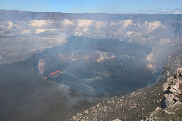
Lower level of Kīlauea's summit lava lake exposes vent wallThe summit lava lake within Halema‘uma‘u Crater today (Jan. 15, 2017) was about 50.5 m (166 ft) below the crater floor (vent rim). One of the most interesting things exposed by the lower lake level was the clear view of the thick, dark veneer of lava on the eastern vent wall (close-up shown below).
Lower level of Kīlauea's summit lava lake exposes vent wall
Lower level of Kīlauea's summit lava lake exposes vent wallThe summit lava lake within Halema‘uma‘u Crater today (Jan. 15, 2017) was about 50.5 m (166 ft) below the crater floor (vent rim). One of the most interesting things exposed by the lower lake level was the clear view of the thick, dark veneer of lava on the eastern vent wall (close-up shown below).