U.S. flag

An official website of the United States government

Images

Volcano Hazard Program images.

Filter Total Items: 6287
Color photograph of sulphur
September 8, 2022 — Mauna Loa Sulphur Cone MultiGas Station Maintenance

Hawai‘i residents may find this photo reminiscent of the Ha‘akulamanu (Sulphur Banks) area of Hawai‘i Volcanoes National Park, though the photo was taken high up on the Southwest Rift Zone of Mauna Loa! In an area known as Sulphur Cone, at an elevation of 3,430 meters (11,240 feet) above sea level, there are bright-yellow crystalline sulfur deposits present.

Hawai‘i residents may find this photo reminiscent of the Ha‘akulamanu (Sulphur Banks) area of Hawai‘i Volcanoes National Park, though the photo was taken high up on the Southwest Rift Zone of Mauna Loa! In an area known as Sulphur Cone, at an elevation of 3,430 meters (11,240 feet) above sea level, there are bright-yellow crystalline sulfur deposits present.

Color photograph of scientist in field
September 8, 2022 — Mauna Loa Sulphur Cone MultiGas Station Maintenance

A Hawaiian Volcano Observatory scientist peers into the fissure that erupted in 1950 from the Southwest Rift Zone of Mauna Loa near Sulphur Cone. Water vapor and sulfur gases are still emitted from this fissure and surrounding area, which is at an elevation of 3,430 meters (11,240 feet) above sea level.

A Hawaiian Volcano Observatory scientist peers into the fissure that erupted in 1950 from the Southwest Rift Zone of Mauna Loa near Sulphur Cone. Water vapor and sulfur gases are still emitted from this fissure and surrounding area, which is at an elevation of 3,430 meters (11,240 feet) above sea level.

Color photograph of cone near coast
September 8, 2022 — Ta‘ū Island Coastal Tuff Cone

The tuff cone on the northwest coast of Ta‘ū Island (near Faleāsao village) is mostly composed of fine-grained ash with larger lithic clasts (fragments of older rock material). Some of these lithic clasts are larger than 1 meter or 3 feet in diameter and are scattered throughout the tuff cone. USGS image by J. Chang.

The tuff cone on the northwest coast of Ta‘ū Island (near Faleāsao village) is mostly composed of fine-grained ash with larger lithic clasts (fragments of older rock material). Some of these lithic clasts are larger than 1 meter or 3 feet in diameter and are scattered throughout the tuff cone. USGS image by J. Chang.

Color photograph of volcano monitoring station
September 8, 2022 — Mauna Loa Sulphur Cone MultiGas Station Maintenance

The gas monitoring site at an elevation of 3,430 meters (11,240 feet) above sea level on the Southwest Rift Zone of Mauna Loa measures volcanic gases (sulfur dioxide, hydrogen sulfide, carbon dioxide and water vapor), fumarole temperature, and meteorological parameters.

The gas monitoring site at an elevation of 3,430 meters (11,240 feet) above sea level on the Southwest Rift Zone of Mauna Loa measures volcanic gases (sulfur dioxide, hydrogen sulfide, carbon dioxide and water vapor), fumarole temperature, and meteorological parameters.

Color photograph of volcano monitoring station
September 8, 2022 — Mauna Loa Sulphur Cone MultiGas Station Maintenance

A photograph showing the inside of the Hawaiian Volcano Observatory (HVO) gas monitoring site at Sulphur Cone, high on the flanks of the Southwest Rift Zone of Mauna Loa. This MultiGas station is one of several that HVO has deployed on the Island of Hawai‘i.

A photograph showing the inside of the Hawaiian Volcano Observatory (HVO) gas monitoring site at Sulphur Cone, high on the flanks of the Southwest Rift Zone of Mauna Loa. This MultiGas station is one of several that HVO has deployed on the Island of Hawai‘i.

Color photograph of scientist deploying instrument in the field
September 7, 2022 — USGS Installs GPS Stations on Ta‘ū Island in American Samoa

USGS staff are on Ta‘ū Island in American Samoa to begin installing Global Positioning System (GPS) receiver monitoring sites. GPS equipment is able to detect very slight movements of the ground and will help the USGS to better understand what is happening beneath the ground and provide more accurate hazard assessments. USGS image by J. Chang.

USGS staff are on Ta‘ū Island in American Samoa to begin installing Global Positioning System (GPS) receiver monitoring sites. GPS equipment is able to detect very slight movements of the ground and will help the USGS to better understand what is happening beneath the ground and provide more accurate hazard assessments. USGS image by J. Chang.

Color photograph of monitoring equipment
September 7, 2022 — USGS Installs GPS Stations on Ta‘ū Island in American Samoa

A USGS scientist checks the power supply at a Global Positioning System (GPS) station on Ta‘ū Island in American Samoa. The station consists of a GPS unit, which can measure changes in ground motion, placed on a tripod that is leveled and centered over a benchmark.

A USGS scientist checks the power supply at a Global Positioning System (GPS) station on Ta‘ū Island in American Samoa. The station consists of a GPS unit, which can measure changes in ground motion, placed on a tripod that is leveled and centered over a benchmark.

Color photograph of monitoring equipment
September 7, 2022 — USGS Installs GPS Stations on Ta‘ū Island in American Samoa

Photograph of a Global Positioning System (GPS) station on Ta‘ū Island in American Samoa. Solar panels and batteries in a weather-proof enclosure power the station, which consists of a GPS unit placed on a tripod that is leveled and centered over a benchmark.

Photograph of a Global Positioning System (GPS) station on Ta‘ū Island in American Samoa. Solar panels and batteries in a weather-proof enclosure power the station, which consists of a GPS unit placed on a tripod that is leveled and centered over a benchmark.

Color photograph of scientist in field
September 6, 2022 — Kīlauea Southwest Rift Zone Seismic Nodes Being Collected

A University of Hawai‘i at Mānoa graduate student uses a compass to check the orientation of a seismic node (blue) that was deployed on Kīlauea's Southwest Rift Zone over the past two months. Seismic nodes are small and light seismometers that measure ground shaking at the location where they are placed.

A University of Hawai‘i at Mānoa graduate student uses a compass to check the orientation of a seismic node (blue) that was deployed on Kīlauea's Southwest Rift Zone over the past two months. Seismic nodes are small and light seismometers that measure ground shaking at the location where they are placed.

Color photograph of lava tree
September 6, 2022 — Kīlauea Southwest Rift Zone Lava Tree

Lava erupted from Kīlauea's Southwest Rift Zone in 1823 formed this lava tree that stands approximately 4 feet (1.2 meters) high. Lava trees form when hot and flowing lava contacts a cool and moist tree, forming a coating of solid lava.

Lava erupted from Kīlauea's Southwest Rift Zone in 1823 formed this lava tree that stands approximately 4 feet (1.2 meters) high. Lava trees form when hot and flowing lava contacts a cool and moist tree, forming a coating of solid lava.

Color photograph of lava tree
September 6, 2022 — Kīlauea Southwest Rift Zone Lava Tree

During the 1823 eruption of Kīlauea's Southwest Rift Zone, lava contacted a tree. It quickly cooled, insulating the tree for a short time from the lava that continued to flow around it.

During the 1823 eruption of Kīlauea's Southwest Rift Zone, lava contacted a tree. It quickly cooled, insulating the tree for a short time from the lava that continued to flow around it.

Color photograph of monitoring equipment
September 6, 2022 — Kīlauea Southwest Rift Zone Seismic Nodes Being Collected

This week, Hawaiian Volcano Observatory (HVO) staff and collaborators from the University of Hawai‘i at Mānoa are collecting seismic nodes on the Southwest Rift Zone of Kīlauea. This photo shows one of the stations, where a battery (silver box) connects to a seismic node being weighed down by a black sand bag.

This week, Hawaiian Volcano Observatory (HVO) staff and collaborators from the University of Hawai‘i at Mānoa are collecting seismic nodes on the Southwest Rift Zone of Kīlauea. This photo shows one of the stations, where a battery (silver box) connects to a seismic node being weighed down by a black sand bag.

Color photograph of scientists in the field
September 6, 2022 — Kīlauea Southwest Rift Zone Seismic Nodes Being Collected

Scientists take notes about the seismic station being collected from the field, where it has been collecting data for the past two months. These temporary seismic node stations were tightly grouped over Kīlauea's Southwest Rift Zone and Pāhala area in order to more densely record earthquake signals across the region.

Scientists take notes about the seismic station being collected from the field, where it has been collecting data for the past two months. These temporary seismic node stations were tightly grouped over Kīlauea's Southwest Rift Zone and Pāhala area in order to more densely record earthquake signals across the region.

Color photograph of scientists in field
September 6, 2022 — Kīlauea Southwest Rift Zone Seismic Nodes Being Collected

Hawaiian Volcano Observatory staff and University of Hawai‘i at Mānoa collaborators walk on lava flows from 1823 along the Hawai‘i Volcanoes National Park boundary fence as they hike to collect seismic nodes that have been deployed in Kīlauea's Southwest Rift Zone for the past two months.

Hawaiian Volcano Observatory staff and University of Hawai‘i at Mānoa collaborators walk on lava flows from 1823 along the Hawai‘i Volcanoes National Park boundary fence as they hike to collect seismic nodes that have been deployed in Kīlauea's Southwest Rift Zone for the past two months.

Color photograph of scientist in the field
September 2, 2022 — Kīlauea summit eruption monitoring

An HVO geologist uses a telephoto camera lens to document Kīlauea's summit eruption from the south rim of Halema‘uma‘u on September 2, 2022. The slope of Mauna Loa's Northeast Rift Zone is visible in the background of the left side of the image, whereas the summit of Kīlauea, at Uēkahuna Bluff, is visible in the background of the right side of the image.

An HVO geologist uses a telephoto camera lens to document Kīlauea's summit eruption from the south rim of Halema‘uma‘u on September 2, 2022. The slope of Mauna Loa's Northeast Rift Zone is visible in the background of the left side of the image, whereas the summit of Kīlauea, at Uēkahuna Bluff, is visible in the background of the right side of the image.

Color photograph of lava lake
September 2, 2022 — Kīlauea summit eruption monitoring

A telephoto view of the active lava lake within Halema‘uma‘u crater, at the summit of Kīlauea volcano. The active lava lake is approximately 3 acres (1 hectare) in area; however, lava flows from this eruption, which began on September 29, 2021, have covered approximately 282 acres (114 hectares). USGS image by K. Mulliken.

A telephoto view of the active lava lake within Halema‘uma‘u crater, at the summit of Kīlauea volcano. The active lava lake is approximately 3 acres (1 hectare) in area; however, lava flows from this eruption, which began on September 29, 2021, have covered approximately 282 acres (114 hectares). USGS image by K. Mulliken.

Color photograph of lava lake
September 2, 2022 — Kīlauea summit eruption monitoring

A view of the eruption in Halema‘uma‘u at the summit of Kīlauea, taken on September 2, 2022, by HVO geologists on the south rim of the crater. Nice weather allowed for clear views of the active lava lake, which is in approximately the center of the image.

A view of the eruption in Halema‘uma‘u at the summit of Kīlauea, taken on September 2, 2022, by HVO geologists on the south rim of the crater. Nice weather allowed for clear views of the active lava lake, which is in approximately the center of the image.

Color photograph of lava pond
September 2, 2022 — Kīlauea summit eruption monitoring

South of the active lava lake within Halema‘uma‘u, there is a much smaller lava pond. Lava flows that appear darker grey and shiny around this feature attest to recent overflows. Telephoto image taken from the south rim of Halema‘uma‘u on September 2, 2022. USGS image by K. Mulliken.

South of the active lava lake within Halema‘uma‘u, there is a much smaller lava pond. Lava flows that appear darker grey and shiny around this feature attest to recent overflows. Telephoto image taken from the south rim of Halema‘uma‘u on September 2, 2022. USGS image by K. Mulliken.

Color photograph of crater edge
September 2, 2022 — Kīlauea summit eruption monitoring

A telephoto view of the eastern end of Halema‘uma‘u crater floor, where lava flows erupted over the past year intersect the crater wall. The fissure that erupted in 1982 on Kīlauea caldera floor is visible as a ridge-like feature about 130 feet (40 meters) above these lava flows. USGS image by K. Mulliken.

A telephoto view of the eastern end of Halema‘uma‘u crater floor, where lava flows erupted over the past year intersect the crater wall. The fissure that erupted in 1982 on Kīlauea caldera floor is visible as a ridge-like feature about 130 feet (40 meters) above these lava flows. USGS image by K. Mulliken.

Color map of islands and nearby bathymetry
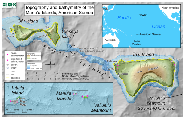
Topography and bathymetry of the Manu‘a Islands, American Samoa

This reference map depicts the topography and bathymetry of the volcanoes in the Manu‘a Islands, American Samoa, where seismic unrest has been ongoing for several weeks. The highest elevation in the area is Lata Mountain on Ta‘ū Island, standing 3,179 feet (969 meters) above sea level.

This reference map depicts the topography and bathymetry of the volcanoes in the Manu‘a Islands, American Samoa, where seismic unrest has been ongoing for several weeks. The highest elevation in the area is Lata Mountain on Ta‘ū Island, standing 3,179 feet (969 meters) above sea level.

Color map of globe
Map showing location of Ta'ū volcano in American Samoa and Wake Island

Wake Island is about 2,800 miles (4,500 km) northwest of Ta'ū volcano in American Samoa. Both are located in the Pacific Ocean. 

Was this page helpful?