U.S. flag

An official website of the United States government

Images

Volcano Hazard Program images.

Filter Total Items: 6273
Color photograph of volcanic vent
October 7, 2021 — Kīlauea eruption

The eruption continues in Halema‘uma‘u crater, at Kīlauea summit. This view from the southern crater rim shows the west vent fountains (center) supplying lava into the western portion of the lava lake. SO2 gas emission rates remain elevated, and were measured at 4,700 tonnes per day on October 7. USGS photo taken by L.

The eruption continues in Halema‘uma‘u crater, at Kīlauea summit. This view from the southern crater rim shows the west vent fountains (center) supplying lava into the western portion of the lava lake. SO2 gas emission rates remain elevated, and were measured at 4,700 tonnes per day on October 7. USGS photo taken by L.

Color photograph of volcanic vent
October 7, 2021 — Kīlauea

The eruption continues in Halema‘uma‘u crater, at the summit of Kīlauea. Lava fountaining no longer emerges from the central portion of the lake, with fountaining limited to the west vent shown here. Low fountaining within the cone supplies lava into the lake via a short spillway. USGS image by M. Patrick.

The eruption continues in Halema‘uma‘u crater, at the summit of Kīlauea. Lava fountaining no longer emerges from the central portion of the lake, with fountaining limited to the west vent shown here. Low fountaining within the cone supplies lava into the lake via a short spillway. USGS image by M. Patrick.

Color photograph of lava lake surface
October 7, 2021 — Kīlauea eruption

This photo from Thursday, October 7, shows the lava lake near the western vent in Halema‘uma‘u crater, at the summit of Kīlauea. The zig zag pattern separating the crustal plates is evident here, as are several spreading zones which cut across the pattern. USGS photo by M. Patrick.

This photo from Thursday, October 7, shows the lava lake near the western vent in Halema‘uma‘u crater, at the summit of Kīlauea. The zig zag pattern separating the crustal plates is evident here, as are several spreading zones which cut across the pattern. USGS photo by M. Patrick.

Color photograph of volcanic vent
October 7, 2021 — Kīlauea eruption

A view of the west vent in Halema‘uma‘u crater, at the summit of Kīlauea. This photo was taken from the northwest caldera rim, providing a good view inside the cone, as well as a view of the small spillway supplying lava into the lake. USGS photo by M. Patrick.

A view of the west vent in Halema‘uma‘u crater, at the summit of Kīlauea. This photo was taken from the northwest caldera rim, providing a good view inside the cone, as well as a view of the small spillway supplying lava into the lake. USGS photo by M. Patrick.

Color webcam photo of lava lake
Kīlauea summit eruption in Halemaʻumaʻu crater - October 7, 2021

KWcam image taken on October 7, 2021, just after 6 a.m. HST. This image shows the ongoing eruption within Halemaʻumaʻu crater at the summit of Kīlauea. The eruption began the afternoon of September 29, 2021, as fissures in the floor of the crater; this activity is generating a lava lake that is slowly filling the crater.

KWcam image taken on October 7, 2021, just after 6 a.m. HST. This image shows the ongoing eruption within Halemaʻumaʻu crater at the summit of Kīlauea. The eruption began the afternoon of September 29, 2021, as fissures in the floor of the crater; this activity is generating a lava lake that is slowly filling the crater.

Color photograph of lava
Crustal foundering in Halema‘uma‘u

A large crustal foundering event in Kīlauea's ongoing Halema‘uma‘u eruption occurred in the late afternoon on October 6, 2021. This photo was taken from the northwest crater rim looking east across the lava lake. USGS Photo: K. Lynn

A large crustal foundering event in Kīlauea's ongoing Halema‘uma‘u eruption occurred in the late afternoon on October 6, 2021. This photo was taken from the northwest crater rim looking east across the lava lake. USGS Photo: K. Lynn

Color photograph of lava fountain
West vent fountain on October 6, 2021

The west vent fountain in Kīlauea's ongoing Halema‘uma‘u eruption was 12 m (39 ft) above the lava lake surface in the late afternoon of October 6, 2021. This photo was taken by USGS geologist K. Lynn from the northwest rim of Halema‘uma‘u looking south.

The west vent fountain in Kīlauea's ongoing Halema‘uma‘u eruption was 12 m (39 ft) above the lava lake surface in the late afternoon of October 6, 2021. This photo was taken by USGS geologist K. Lynn from the northwest rim of Halema‘uma‘u looking south.

Color graphic showing lava lake depth in crater relative to Empire State Building
Halema‘uma‘u lava lake depth compared to Empire State Building

On September 29, 2021, fissure vents opened in Halema‘uma‘u crater. A new lava lake began to form on the one previously active from December 2020–May 2021.

Color map showing lava lake eruption features
October 5, 2021—Kīlauea summit eruption reference map

This reference map depicts the ongoing Kīlauea summit eruption on October 5, 2021. Two eruptive vents are active at this time: one along the western edge of the rising lava lake, and one within the south-central portion of the lake.

This reference map depicts the ongoing Kīlauea summit eruption on October 5, 2021. Two eruptive vents are active at this time: one along the western edge of the rising lava lake, and one within the south-central portion of the lake.

Color photograph of vent and lava lake
Close-up view of west vent, Halema‘uma‘u, Kīlauea - October 5, 2021

Photo of fountaining from the western vent in Halema‘uma‘u crater, at the summit of Kīlauea. Spatter from the fountain continues to build up a horseshoe-shaped cone around the vent, with lava flowing into the lake at the base. This photo was taken from the western crater rim on October 5, 2021. USGS photo by N. Deligne.

Photo of fountaining from the western vent in Halema‘uma‘u crater, at the summit of Kīlauea. Spatter from the fountain continues to build up a horseshoe-shaped cone around the vent, with lava flowing into the lake at the base. This photo was taken from the western crater rim on October 5, 2021. USGS photo by N. Deligne.

Color photograph of scientist monitoring eruption
HVO geologist observing lava lake in Halema‘uma‘u - October 5, 2021

A Hawaiian Volcano Observatory (HVO) geologist notes observations of the active lava lake in Halema‘uma‘u crater, at the summit of Kīlauea. HVO scientists continue to monitor the ongoing eruption from an area within Hawai‘i Volcanoes National Park that remains closed to the public due to hazardous conditions. USGS photo taken by N. Deligne on October 5, 2021.

A Hawaiian Volcano Observatory (HVO) geologist notes observations of the active lava lake in Halema‘uma‘u crater, at the summit of Kīlauea. HVO scientists continue to monitor the ongoing eruption from an area within Hawai‘i Volcanoes National Park that remains closed to the public due to hazardous conditions. USGS photo taken by N. Deligne on October 5, 2021.

Color photograph of active lava lake
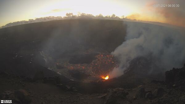
Kīlauea summit eruption in Halema‘uma‘u crater - October 5, 2021

A view of the lava lake in Halema‘uma‘u crater, at the summit of Kīlauea, taken from the western crater rim looking east. The western vent (lower right) remains the dominant source of fountaining. One fountain remains active in the south portion of the lake (center right).

A view of the lava lake in Halema‘uma‘u crater, at the summit of Kīlauea, taken from the western crater rim looking east. The western vent (lower right) remains the dominant source of fountaining. One fountain remains active in the south portion of the lake (center right).

Color photograph of volcanic vent
Western fissure, Halema‘uma‘u, Kīlauea - October 5, 2021

Lava fountains from the western fissure vent in the Halema‘uma‘u crater wall, at Kīlauea's summit during the ongoing eruption. USGS video by N. Deligne.

Scientist on crater rim uses equipment to measure volcanic gases emitted from the active lava lake below
HVO scientist uses a field FTIR

An HVO scientist aims the ‘field FTIR’ at spattering lava from the current eruption in Halema‘uma‘u crater, at Kīlauea summit, on October 4, 2021. USGS photo by P. Nadeau. 

An HVO scientist aims the ‘field FTIR’ at spattering lava from the current eruption in Halema‘uma‘u crater, at Kīlauea summit, on October 4, 2021. USGS photo by P. Nadeau. 

zoomed-in view of the erupting western fissure in Halema‘uma‘u shows lava fountaining activity
Kīlauea summit eruption in Halemaʻumaʻu crater - October 4, 2021

This zoomed-in view of the erupting western fissure in Halema‘uma‘u shows lava fountaining activity on the morning of October 4, 2021. The fountains have built a C-shaped spatter rampart around their source, which is now submerged in the rising lava lake.

This zoomed-in view of the erupting western fissure in Halema‘uma‘u shows lava fountaining activity on the morning of October 4, 2021. The fountains have built a C-shaped spatter rampart around their source, which is now submerged in the rising lava lake.

Color photograph of lava lake surface
Kīlauea summit eruption in Halemaʻumaʻu crater - October 4, 2021

A telephoto view of foundering in the active lava lake within Halema‘uma‘u crater, at the summit of Kīlauea. Foundering occurs when denser and cooler solidified crust (black) sinks below less dense liquid lava (orange). Photo taken at 7:48 a.m. HST on October 4, 2021. USGS photo by J.M. Chang.

A telephoto view of foundering in the active lava lake within Halema‘uma‘u crater, at the summit of Kīlauea. Foundering occurs when denser and cooler solidified crust (black) sinks below less dense liquid lava (orange). Photo taken at 7:48 a.m. HST on October 4, 2021. USGS photo by J.M. Chang.

zoomed-in view of the eastern edge of the main island in the Halema‘uma‘u lava lake
Kīlauea summit eruption in Halemaʻumaʻu crater - October 4, 2021

This photo, captured on the morning of October 4, 2021, provides a zoomed-in view of the eastern edge of the main island in the Halema‘uma‘u lava lake. In the earliest days of the ongoing Kīlauea eruption, this was the site of an energetic eruptive vent that showered the island with spatter and tephra.

This photo, captured on the morning of October 4, 2021, provides a zoomed-in view of the eastern edge of the main island in the Halema‘uma‘u lava lake. In the earliest days of the ongoing Kīlauea eruption, this was the site of an energetic eruptive vent that showered the island with spatter and tephra.

A telephoto image of fountaining from the western vent in Halema‘uma‘u crater, at the summit of Kīlauea
Kīlauea summit eruption in Halemaʻumaʻu crater - October 4, 2021

A telephoto image of fountaining from the western vent in Halema‘uma‘u crater, at the summit of Kīlauea. Spatter from the fountain continues to build up a cone around the vent, which is almost entirely out of view from this angle. This photo was taken from the western crater rim on October 4, 2021. USGS photo by M. Patrick.

A telephoto image of fountaining from the western vent in Halema‘uma‘u crater, at the summit of Kīlauea. Spatter from the fountain continues to build up a cone around the vent, which is almost entirely out of view from this angle. This photo was taken from the western crater rim on October 4, 2021. USGS photo by M. Patrick.

A brief gap in the fume provides a clear view of the fountaining at the western vent in Halema‘uma‘u crater,
Kīlauea summit eruption in Halemaʻumaʻu crater - October 4, 2021

A brief gap in the fume provides a clear view of the fountaining at the western vent in Halema‘uma‘u crater, at the summit of Kīlauea. Sulfur dioxide (SO2) emission rates remain elevated and were measured at approximately 7,000 tonnes per day on October 4. USGS photo taken by M. Patrick from the southern crater rim on October 4, 2021.

A brief gap in the fume provides a clear view of the fountaining at the western vent in Halema‘uma‘u crater, at the summit of Kīlauea. Sulfur dioxide (SO2) emission rates remain elevated and were measured at approximately 7,000 tonnes per day on October 4. USGS photo taken by M. Patrick from the southern crater rim on October 4, 2021.

A geologist uses a laser rangefinder to measure the elevation of the active lava lake in Halema‘uma‘u crater
Kīlauea summit eruption in Halemaʻumaʻu crater - October 4, 2021

A Hawaiian Volcano Observatory (HVO) geologist uses a laser rangefinder to measure the elevation of the active lava lake in Halema‘uma‘u crater, at the summit of Kīlauea. HVO scientists continue to monitor the ongoing eruption from an area within Hawai‘i Volcanoes National Park that remains closed to the public due to safety concerns. USGS photo taken by M.

A Hawaiian Volcano Observatory (HVO) geologist uses a laser rangefinder to measure the elevation of the active lava lake in Halema‘uma‘u crater, at the summit of Kīlauea. HVO scientists continue to monitor the ongoing eruption from an area within Hawai‘i Volcanoes National Park that remains closed to the public due to safety concerns. USGS photo taken by M.

A telephoto view of fountaining at the western vent in Halema‘uma‘u crater
Kīlauea summit eruption in Halemaʻumaʻu crater - October 4, 2021

A telephoto view of fountaining at the western vent in Halema‘uma‘u crater, at the summit of Kīlauea. Spatter from the fountain has built a horseshoe-shaped cone around the vent in the western crater wall. Molten spatter accumulating on the cone forms a tiny stream of lava down the north side (bottom center).

A telephoto view of fountaining at the western vent in Halema‘uma‘u crater, at the summit of Kīlauea. Spatter from the fountain has built a horseshoe-shaped cone around the vent in the western crater wall. Molten spatter accumulating on the cone forms a tiny stream of lava down the north side (bottom center).

Was this page helpful?