An official website of the United States government
Here's how you know
Official websites use .gov
A .gov website belongs to an official government organization in the United States.
Secure .gov websites use HTTPS
A lock () or https:// means you’ve safely connected to the .gov website. Share sensitive information only on official, secure websites.
I spy with my little (eagle-) eye . . .After a successful beach survey and installation of remote-sensing cameras on a nearby island, scientists Shawn Harrison and Andrew Stevens spotted this bald eagle near the mouth of the Skagit River, Washington. More: https://www.usgs.gov/centers/pcmsc/science/using-video-imagery-study-co…
Synchronized mappingUSGS and Washington State Department of Ecology scientists are geared up and ready to start a topographic survey at the mouth of the Elwha River, using handheld computers and backpack-mounted GPS equipment. The river continues changing years after the largest dam removal project in the United States. More: https://usgs.gov/elwha
The Long and Winding... RiverA winding strip of rainbow colors shows the bathymetry (depth) of the bed of the Mokelumne River just above its confluence with the San Joaquin River in the Sacramento-San Joaquin River Delta east of San Francisco Bay, California. USGS scientists mapped the channel as part of a project to assess the impact of invasive aquatic vegetation on sediment movement in the Delta. More: https://www.usgs.gov/centers/ca-water/science/ecosystem-engineers-impac…
Cheboygan residents tour the R/V SturgeonUSGS Great Lakes Science Center staff led two public tours of the research vessels Sturgeon and Arcticus on April 24, 2019, as part of the Earth Week Plus Expo in Cheboygan, Michigan. A group of fifty tour participants learned about USGS Great Lakes science, viewed the variety of scientific equipment used during field surveys, and saw the inner workings of the vessels. More: https://www.usgs.gov/centers/glsc
Glaucous-winged Gull chick on Bogoslof Island, AlaskaLess than year after the last eruption of Bogoslof Volcano, this baby gull took some of its first steps on the newly-formed rocks. As adults, these coastal birds can be found from the eastern Russia, through Alaska and the U.S. West Coast south to Mexico’s Baja California peninsula. The gulls are one of 28 bird species the USGS monitors for avian influenza. More: https://www.usgs.gov/centers/asc/science/high-priority-species-avian-in…
Peace at duskUSGS oceanographer Shawn Harrison stands on the coastal bluff of Barter Island, Alaska at sunset. Shawn and his fellow researchers are studying how the highly erosive bluff changes under the varied conditions experienced by this stretch of coastline. The knowledge gained will be used to improve computer-derived simulations of shoreline change. Communities can then use the information to plan for sea-level rise, changing storm patterns, and other threats to coasts. More: https://www.usgs.gov/centers/pcmsc/science/climate-impacts-arctic-coasts
Male or female? It depends.Sea lampreys are an invasive, parasitic species of fish damaging the Great Lakes. Scientists with the USGS and Michigan State University found that slower sea lamprey growth rates during the larval phase of development may increase the odds of an individual fish becoming male. More: https://www.usgs.gov/news/sex-shifting-fish-growth-rate-could-determine…
USGS pilot landing a drone on Dauphine Island, AlabamaA USGS unmanned aerial system (drone) pilot collected aerial imagery and ground control points for the Coastal Resource Evaluation for Management Applications project. Computer analysis of these photos can produce detailed elevation, vegetation, and habitat maps used to study coastal changes. More: https://www.usgs.gov/centers/whcmsc/science/aerial-imaging-and-mapping
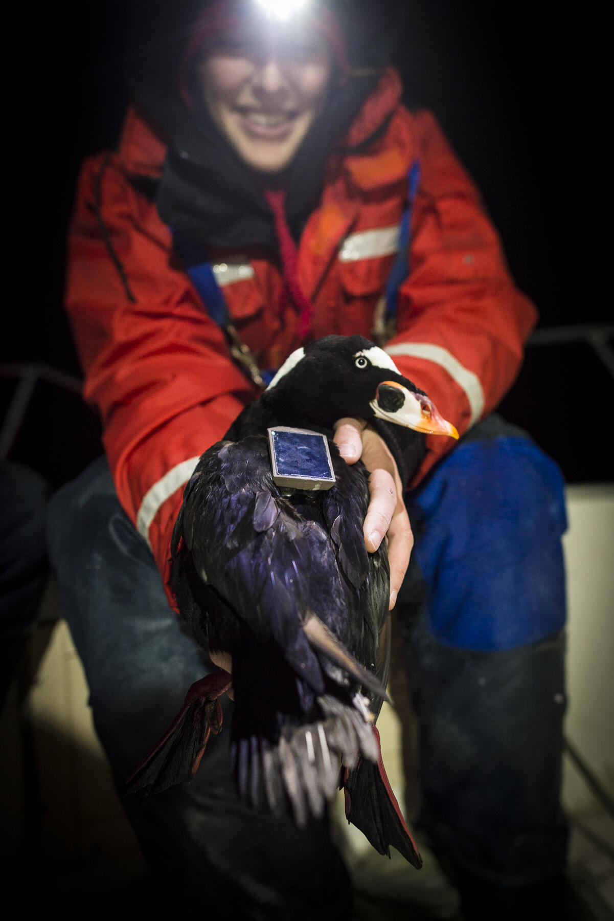
Surf scoter sporting a satellite tagUSGS scientist Sarah Fitzgerald holds a surf scoter fitted with a satellite tag that transmits the bird’s location to satellites. By knowing the distribution and migration patterns of seabirds, offshore wind energy farms could be located and operated to minimize wildlife impacts. More: https://www.usgs.gov/centers/pwrc/science/wind-energy
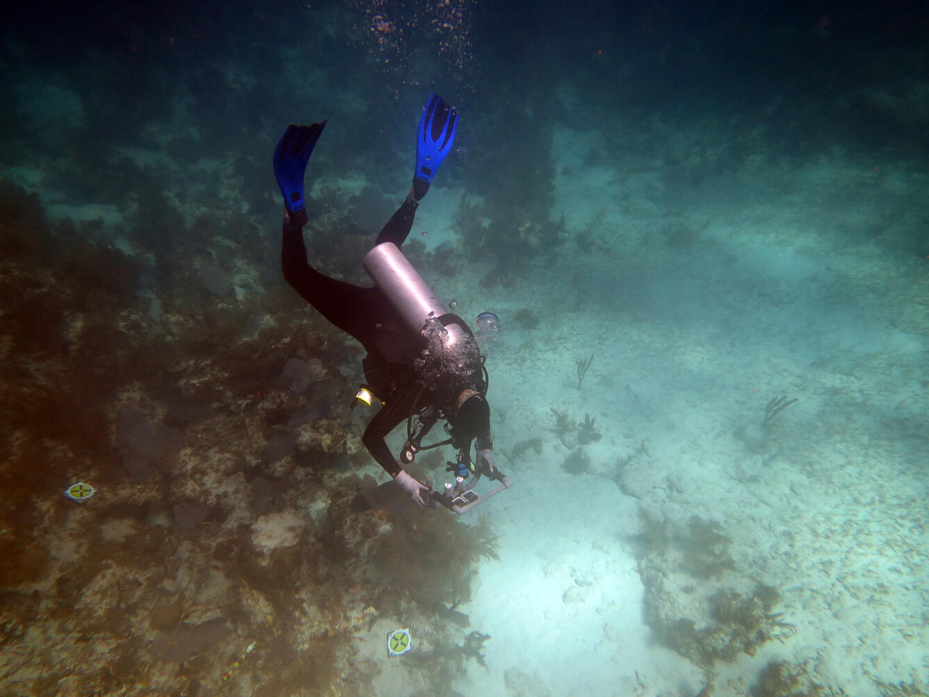
Surveying a coral reef using underwater photographyEarlier this year, USGS scientist Lauren Toth conducted a photographic survey of Porter Patch reef off Key Largo, Florida, one of several sites surveyed since 1996. The new reef photos will be compared to historic surveys to determine how much structural complexity was lost over the past two decades. More: https://www.usgs.gov/centers/spcmsc/science/coral-reef-ecosystem-studie…
Recent Coastal and Marine Fieldwork - April-May 2019
In May 2019, USGS coastal and marine scientists visited several coastal and offshore locations, studying reservoir sediment after a wildfire disaster...
Recent Coastal and Marine Fieldwork - April-May 2019
In May 2019, USGS coastal and marine scientists visited several coastal and offshore locations, studying reservoir sediment after a wildfire disaster...