
USGS is actively pursuing research in earthquake early warning.
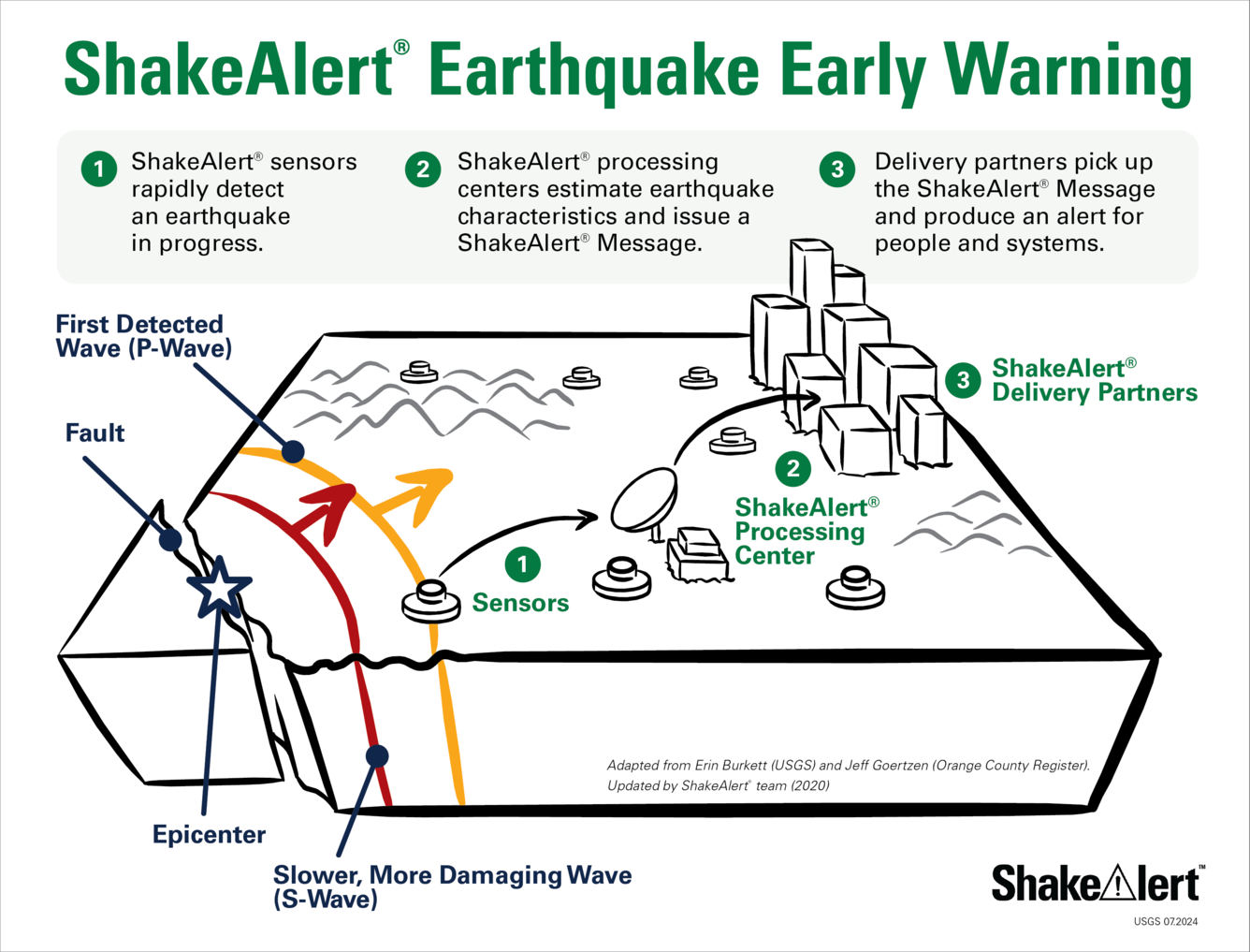
How the ShakeAlert® System Works
DETECT, DELIVER, PROTECT: ShakeAlert® is not earthquake prediction. Rather, the USGS-operated ShakeAlert Earthquake Early Warning system detects an earthquake that has already started and estimates its location, magnitude and shaking intensity. If an earthquake becomes large enough to meet USGS alert thresholds, a ShakeAlert Message is issued. Then, technical partners, which have entered into a license agreement with the USGS, use this information produce and deliver an alert that prompts people to take a protective action, such as DROP, COVER, AND HOLD ON, and/or to trigger an automated action that can protect vital systems, equipment, facilities, and infrastructure. These automated actions could include slowing a train, closing valves, issuing a public announcement, and many others.
The ShakeAlert system takes a network approach to earthquake detection and alerting. This network uses sensors distributed over a wide area where earthquakes are likely to occur on the West Coast of the United States (with nearly 1,700 anticipated on network build-out). Data from individual sensors across large regions are combined to maximize accuracy and alerting time during moderate-to-large earthquakes.

During an earthquake, a rupturing fault produces several different kinds of waves that carry energy away
from the epicenter like ripples from a rock thrown into a pond. The fastest-moving seismic waves (primary or P-waves) travel about 3.7 miles per second and generally do not produce strong shaking. P-waves are followed by slower moving, and generally more damaging waves (secondary or S-waves) and surface waves that travel about 2.5 miles per second. The ShakeAlert sensor network detects earthquakes quickly, and immediately transmits data to a ShakeAlert Processing Center, where estimates of the location, size, and shaking intensity of the earthquake are determined in a matter of seconds.
Technical Partners are integral to the ShakeAlert System because they are responsible for producing and delivering ShakeAlert-powered alerts to people and critical systems. Technical Partners span multiple industries and sectors, and include private for-profit companies, public entities, and nonprofits that can benefit from becoming part of the ShakeAlert System.
ShakeAlert works because:
- P-waves travel almost twice as fast as the damaging S-waves and surface waves; and
- The speeds of today’s data telecommunications systems are many times faster than seismic waves. Both of these factors make it possible for ShakeAlert-powered alerts to reach people before shaking arrives. Because of the speed difference between P-waves, S-waves, and surface waves, someone who is farther from the earthquake’s origin has more time to potentially receive an alert before shaking arrives.
ShakeAlert®-Powered Alert Delivery Levels
If an earthquake becomes large enough to meet USGS alert thresholds, a ShakeAlert Message is issued. ShakeAlert technical partners use this information to produce and deliver alerts that rapidly prompts people to take a protective action, such as DROP, COVER, AND HOLD ON, and/or to trigger an automated action that can protect vital systems, equipment, facilities, and infrastructure. These automated actions could include slowing a train, closing valves, issuing a public announcement, and many others.
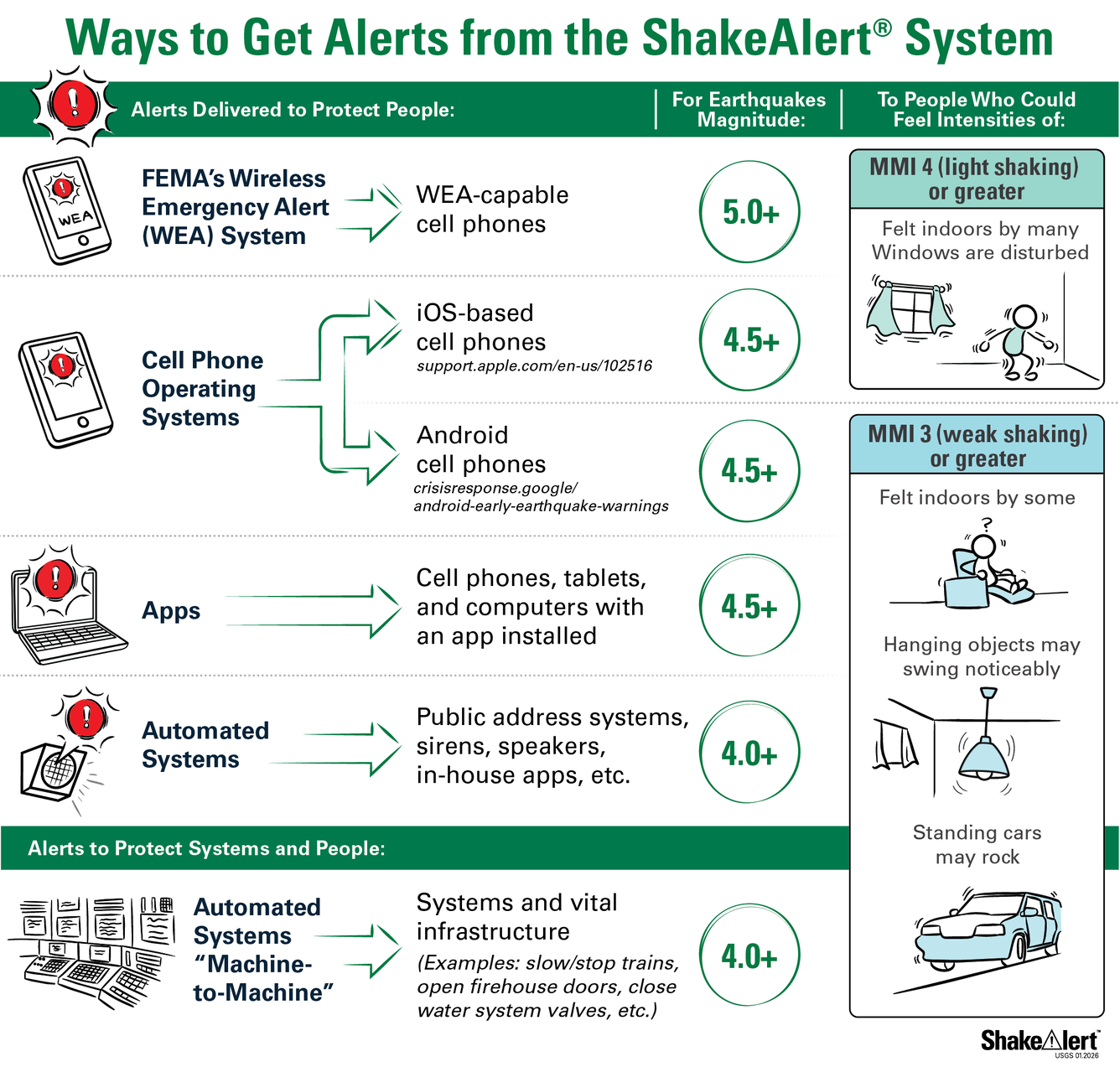
For example, cell phone app providers and Android can deliver ShakeAlert-powered alerts to people who could feel weak shaking (Modified Mercalli Intensity - MMI III) or greater for earthquakes M4.5 and larger. For people who could feel moderate shaking (MMI V) or greater Android delivers alerts with more urgent language.
The Modified Mercalli Intensity (MMI) Scale is composed of increasing levels of intensity that range from imperceptible shaking to catastrophic destruction; levels of intensity are designated by Roman numerals. The MMI Scale does not have a mathematical basis; instead, it is a holistic ranking based on observed effects. The lower range of the MMI scale generally deals with the manner in which the earthquake is felt by people. The higher range considers observed structural damage.

For More Information:

How do I sign up for the ShakeAlert® Earthquake Early Warning System? How do I sign up for the ShakeAlert® Earthquake Early Warning System?
How do I sign up to receive ShakeAlert®-powered Alerts on my phone? Provider Type Apple Store Google Play Link States USGS/FEMA Wireless Emergency Alerts N/A FEMA | WEA CA/OR/WA MyShake TM Mobile App Y/Y MyShake CA/OR/WA Google Android Operating System N/A Google CA/OR/WA Alert San Diego with ShakeReadySD Mobile App Y/Y Alert San Diego CA The USGS issues ShakeAlert ® Messages but alert delivery...

Can I get on a list to receive an email message when there is an earthquake? How do I sign up for earthquake notifications? Are there any Feeds I can subscribe to? Can I get on a list to receive an email message when there is an earthquake? How do I sign up for earthquake notifications? Are there any Feeds I can subscribe to?
Please go to the USGS Earthquake Notification Services (ENS) to sign up for free emails or text messages to your phone. Use the default settings or customize ENS to fit your needs. Also check out the many different Earthquake Feeds. ENS is NOT an earthquake early warning system. Messages issued by ENS will almost always arrive after you would feel any shaking. Learn more: How do I sign up for...
USGS is actively pursuing research in earthquake early warning.
How the ShakeAlert® System Works
DETECT, DELIVER, PROTECT: ShakeAlert® is not earthquake prediction. Rather, the USGS-operated ShakeAlert Earthquake Early Warning system detects an earthquake that has already started and estimates its location, magnitude and shaking intensity. If an earthquake becomes large enough to meet USGS alert thresholds, a ShakeAlert Message is issued. Then, technical partners, which have entered into a license agreement with the USGS, use this information produce and deliver an alert that prompts people to take a protective action, such as DROP, COVER, AND HOLD ON, and/or to trigger an automated action that can protect vital systems, equipment, facilities, and infrastructure. These automated actions could include slowing a train, closing valves, issuing a public announcement, and many others.
The ShakeAlert system takes a network approach to earthquake detection and alerting. This network uses sensors distributed over a wide area where earthquakes are likely to occur on the West Coast of the United States (with nearly 1,700 anticipated on network build-out). Data from individual sensors across large regions are combined to maximize accuracy and alerting time during moderate-to-large earthquakes.
During an earthquake, a rupturing fault produces several different kinds of waves that carry energy away
from the epicenter like ripples from a rock thrown into a pond. The fastest-moving seismic waves (primary or P-waves) travel about 3.7 miles per second and generally do not produce strong shaking. P-waves are followed by slower moving, and generally more damaging waves (secondary or S-waves) and surface waves that travel about 2.5 miles per second. The ShakeAlert sensor network detects earthquakes quickly, and immediately transmits data to a ShakeAlert Processing Center, where estimates of the location, size, and shaking intensity of the earthquake are determined in a matter of seconds.
Technical Partners are integral to the ShakeAlert System because they are responsible for producing and delivering ShakeAlert-powered alerts to people and critical systems. Technical Partners span multiple industries and sectors, and include private for-profit companies, public entities, and nonprofits that can benefit from becoming part of the ShakeAlert System.
ShakeAlert works because:
- P-waves travel almost twice as fast as the damaging S-waves and surface waves; and
- The speeds of today’s data telecommunications systems are many times faster than seismic waves. Both of these factors make it possible for ShakeAlert-powered alerts to reach people before shaking arrives. Because of the speed difference between P-waves, S-waves, and surface waves, someone who is farther from the earthquake’s origin has more time to potentially receive an alert before shaking arrives.
ShakeAlert®-Powered Alert Delivery Levels
If an earthquake becomes large enough to meet USGS alert thresholds, a ShakeAlert Message is issued. ShakeAlert technical partners use this information to produce and deliver alerts that rapidly prompts people to take a protective action, such as DROP, COVER, AND HOLD ON, and/or to trigger an automated action that can protect vital systems, equipment, facilities, and infrastructure. These automated actions could include slowing a train, closing valves, issuing a public announcement, and many others.
For example, cell phone app providers and Android can deliver ShakeAlert-powered alerts to people who could feel weak shaking (Modified Mercalli Intensity - MMI III) or greater for earthquakes M4.5 and larger. For people who could feel moderate shaking (MMI V) or greater Android delivers alerts with more urgent language.
The Modified Mercalli Intensity (MMI) Scale is composed of increasing levels of intensity that range from imperceptible shaking to catastrophic destruction; levels of intensity are designated by Roman numerals. The MMI Scale does not have a mathematical basis; instead, it is a holistic ranking based on observed effects. The lower range of the MMI scale generally deals with the manner in which the earthquake is felt by people. The higher range considers observed structural damage.
For More Information:
How do I sign up for the ShakeAlert® Earthquake Early Warning System? How do I sign up for the ShakeAlert® Earthquake Early Warning System?
How do I sign up to receive ShakeAlert®-powered Alerts on my phone? Provider Type Apple Store Google Play Link States USGS/FEMA Wireless Emergency Alerts N/A FEMA | WEA CA/OR/WA MyShake TM Mobile App Y/Y MyShake CA/OR/WA Google Android Operating System N/A Google CA/OR/WA Alert San Diego with ShakeReadySD Mobile App Y/Y Alert San Diego CA The USGS issues ShakeAlert ® Messages but alert delivery...
Can I get on a list to receive an email message when there is an earthquake? How do I sign up for earthquake notifications? Are there any Feeds I can subscribe to? Can I get on a list to receive an email message when there is an earthquake? How do I sign up for earthquake notifications? Are there any Feeds I can subscribe to?
Please go to the USGS Earthquake Notification Services (ENS) to sign up for free emails or text messages to your phone. Use the default settings or customize ENS to fit your needs. Also check out the many different Earthquake Feeds. ENS is NOT an earthquake early warning system. Messages issued by ENS will almost always arrive after you would feel any shaking. Learn more: How do I sign up for...