
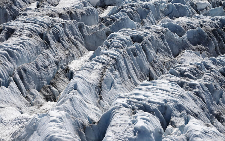
Lemon Creek Glacier is located in the high-latitude maritime region of Alaska, at the southernmost tip of the Juneau Icefield. Glacier observations began at this site in 1953.
2025 USGS Benchmark Glaciers Executive Summary
Active
By Ecosystems Land Change Science Program
April 15, 2026
2025 Data Now Available: Explore how the USGS Benchmark Glaciers have changed in 2025
Return to Glaciers and Landscape Change
Explore the USGS Benchmark Glaciers mass balance methods for measuring glacier change
2025 Benchmark Glacier Results
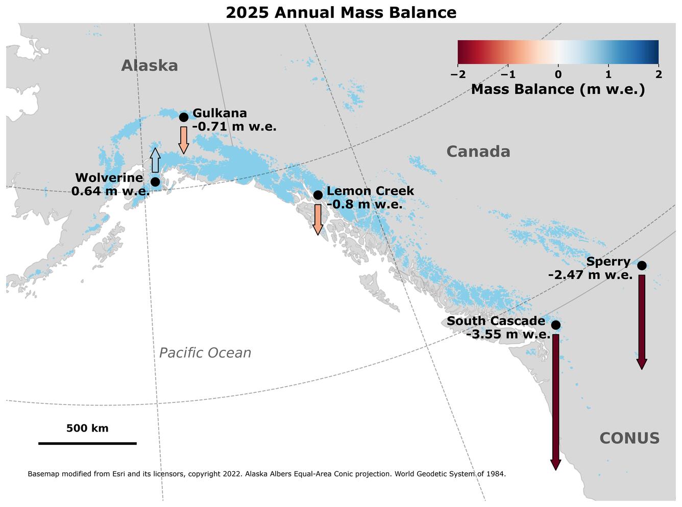
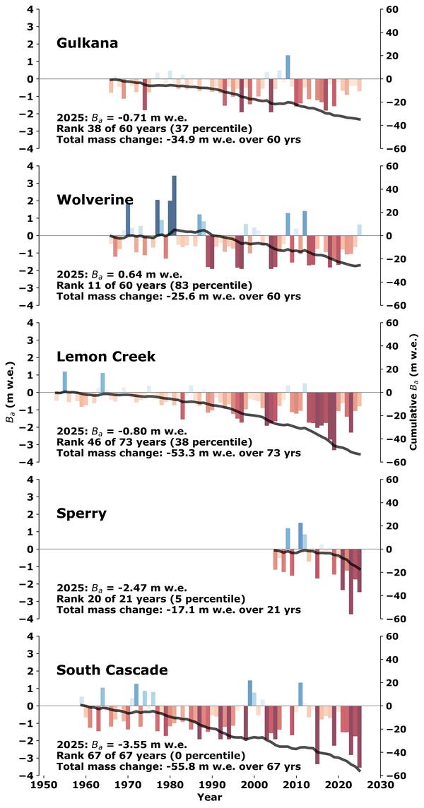
Benchmark Glaciers in Alaska had variable (and modest) mass gains and losses (Fig. 1).
- Wolverine Glacier gained mass in 2025, the first time since 2012.
- Gulkana and Lemon Creek Glaciers lost mass for the 17th and 13th consecutive years, respectively.
Benchmark Glaciers in the contiguous states had record and near record mass losses
- Glacier mass loss at South Cascade Glacier (Washington) was the highest on record.
- Mass loss at Sperry Glacier (Montana) was the second highest on record.
Overall, 2025 USGS Benchmark Glacier mass change was characterized by glacier mass loss driven primarily by warm summer conditions, with Wolverine Glacier as a notable exception.
Media
Sources/Usage: Public Domain. View Media Details
How did 2025 annual mass balances compare to previous years?
In Alaska, Gulkana and Lemon Creek glaciers experienced moderate mass loss, marking their 17th and 13th consecutive years of negative annual mass balance, respectively. Conversely, Wolverine Glacier experienced moderate mass gain — its first positive annual mass balance since 2012, ending a 12-year streak of negative balances. In the contiguous United States, Sperry Glacier in Glacier National Park, Montanna saw its second highest mass loss year since measurements began in 2005. South Cascade Glacier in the Cascade Mountains of Washington underwent the greatest mass loss year since measurements began in 1958 (Fig. 2.).
Media
Sources/Usage: Public Domain. View Media Details
How did winter snowfall contribute to each glacier's mass balance?
At Wolverine Glacier, winter precipitation exceeded normal levels beginning in November and remained above average throughout the remainder of the 2024 – 25 accumulation season. Lemon Creek Glacier experienced near-normal winter precipitation through the accumulation season. At Sperry Glacier, precipitation began accumulating approximately one month later than the 1991-2020 mean. Gulkana, Sperry, and South Cascade glaciers all ended the 2024 – 25 accumulation season with below-average winter precipitation (Fig. 3.).
Media
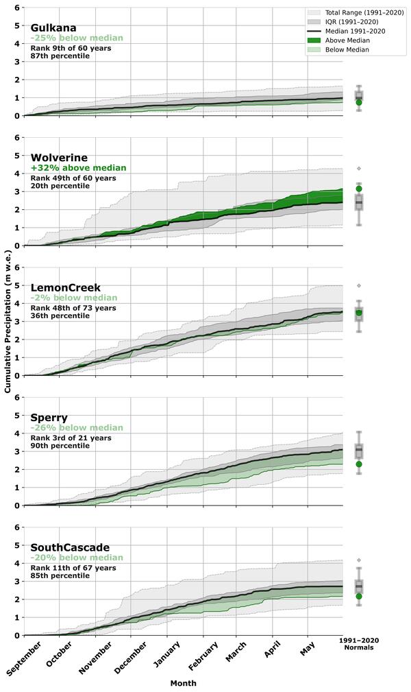
Fig. 3. Cumulative 2024 – 25 accumulation season precipitation (m w.e.), Sept. 1–May 30th, at the median elevation of each USGS Benchmark glacier, based on local weather station data (O'Neel et al., 2019; https://doi.org/10.5066/F7HD7SRF). The bold black line shows the 1991–2020 median, with dark gray shading indicating the interquartile range and light gray shading the total historical range for the reference period. Dark green shading indicates periods where 2025 accumulation exceeded the 1991–2020 median; light green shading indicates periods where it fell below. Boxplots at right summarize the full period-of-record distribution of seasonal precipitation totals for each glacier, with the box spanning the interquartile range, the internal line marking the median, whiskers extending to the total range, and the colored dot indicating the 2025 seasonal value. Rank and percentile are reported relative to each glacier's individual period of record. Total winter precipitation ranks are reported from lowest (driest) to highest (wettest).
Sources/Usage: Public Domain. View Media Details
How did summer temperatures contribute to each glacier's mass balance?
All three Alaska glaciers experienced cooler than average temperatures during the first half of summer, limiting melt. Wolverine and Gulkana Glaciers had a delayed start to the ablation season. At Wolverine Glacier remained cooler than average through the end of summer, contributing to its positive mass balance. Gulkana and Lemon Creek glaciers ended the summer moderately warmer than average, offsetting some of the effects of the cool early season. In the contiguous United States, both Sperry and South Cascade glaciers experienced significantly warmer than average temperatures throughout the summer, driving the exceptional mass loss observed at both sites (Fig. 4.).
Media
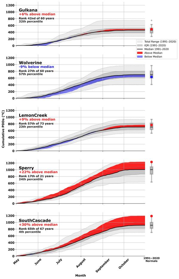
Fig. 4. Cumulative 2025 ablation season positive degree days (sum of daily mean temperatures >0°C, when the glacier is melting), May 1–Oct. 30th, at each USGS Benchmark glacier’s median elevation based on local weather station data (O'Neel et al., 2019; https://doi.org/10.5066/F7HD7SRF). The bold black line shows the 1991–2020 median, with dark gray shading indicating the interquartile range and light gray shading the total historical range for the reference period. Red shading indicates periods where 2025 accumulation exceeded the 1991–2020 median; blue shading indicates periods where it fell below. Boxplots at right summarize the full period-of-record distribution of seasonal PDD totals for each glacier, with the box spanning the interquartile range, the internal line marking the median, whiskers extending to the total range, and the colored dot indicating the 2025 seasonal value. Rank and percentile are reported relative to each glacier's individual period of record. Ablation season ranks are reported from lowest (coolest) to highest (warmest).
Sources/Usage: Public Domain. View Media Details
Explore the USGS Benchmark Glaciers in context of global glacier studies

Glaciers and Landscape Change
Mountain glaciers are dynamic reservoirs of frozen water, deeply interconnected with their surrounding ecosystems. Glacier change in North America has major societal impacts, including to water resources, natural hazard risk, tourism disruption, fisheries, and global sea level change. Understanding and quantifying precise connections between changing glaciers, the surrounding landscape and climate...
Aerial photographs of South Cascade Glacier represent 57 years of change
Aerial photograph of South Cascade Glacier, WA taken August 13th, 1958 (before image) and October 14th, 2015 (after image).
Filter Total Items: 77

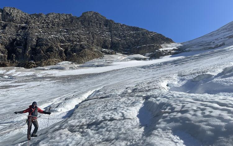
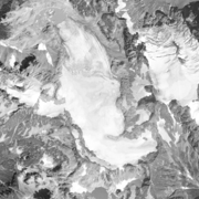
Lemon Creek Glacier in the spring
Lemon Creek Glacier is located in the high-latitude maritime region of Alaska, at the southernmost tip of the Juneau Icefield. Glacier observations began at this site in 1953.

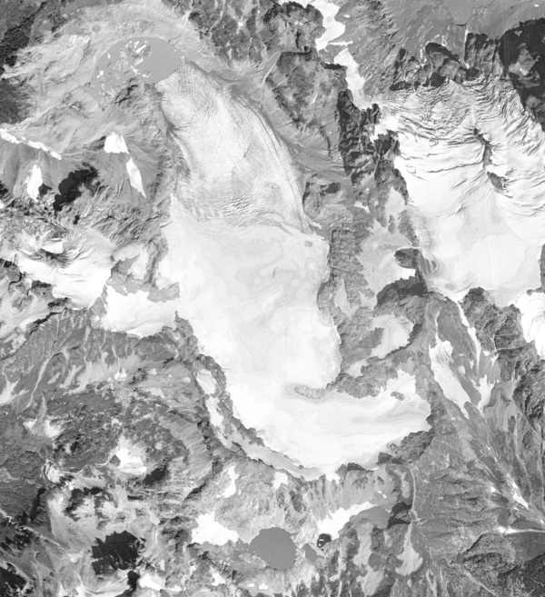
Sperry Glacier area change, 1950 - 2014
Sperry Glacier area change, 1950 - 2014. Sperry Glacier occupies a broad, shallow cirque situated just beneath and west of the Continental Divide in the Lewis Mountain Range of Glacier National Park, Montana.
Sperry Glacier area change, 1950 - 2014. Sperry Glacier occupies a broad, shallow cirque situated just beneath and west of the Continental Divide in the Lewis Mountain Range of Glacier National Park, Montana.

Scientist collecting samples on South Cascade Glacier
Scientist collecting samples on South Cascade GlacierScientist collection samples on South Cascade Glacier, northwestern Washington State. South Cascade Glacier located in a north-northwest facing valley near the crest of the Cascade Range in northwest Washington state. In 1959 scientists with the USGS began collecting mass balance data on South Cascade Glacier, now one of five "benchmark glaciers" in the US.

The Gulkana Glacier weather station
The Gulkana Glacier weather station collects data on air temperature, wind speed and direction, and cumulative precipitation.
The Gulkana Glacier weather station collects data on air temperature, wind speed and direction, and cumulative precipitation.

Wolverine Glacier Ice
Photo of Wolverine Glacier ice. Wolverine Glacier is in the Kenai Mountains on the coast of south-central Alaska. In 1966 scientists with the USGS began making direct measurements of surface mass balance at Wolverine Glacier, a "benchmark glacier" in Alaska.
Photo of Wolverine Glacier ice. Wolverine Glacier is in the Kenai Mountains on the coast of south-central Alaska. In 1966 scientists with the USGS began making direct measurements of surface mass balance at Wolverine Glacier, a "benchmark glacier" in Alaska.

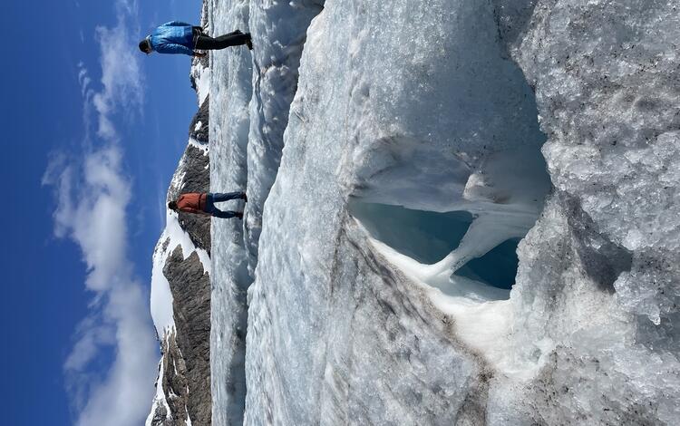
A hand-dug snow pit on Sperry Glacier
From a hand-dug snow pit, a researcher samples cores of surface snow at Sperry Glacier to determine snow density, a measure needed to calculate glacier mass balance.
From a hand-dug snow pit, a researcher samples cores of surface snow at Sperry Glacier to determine snow density, a measure needed to calculate glacier mass balance.

Aerial image of Taku Glacier, Alaska 1948
Aerial image of Taku Glacier in 1948. The Norris Glacier can be seen on the lower left hand corner and the Hole-in-the-Wall Glacier in the upper center portion of the image. Citation: McNeil, C. J., and Baker, E. H., 2019, Geodetic data for Juneau Icefield Glaciers: orthophotos, digital elevation models, and glacier boundaries (ver 1.0, August, 2019): U.S.
Aerial image of Taku Glacier in 1948. The Norris Glacier can be seen on the lower left hand corner and the Hole-in-the-Wall Glacier in the upper center portion of the image. Citation: McNeil, C. J., and Baker, E. H., 2019, Geodetic data for Juneau Icefield Glaciers: orthophotos, digital elevation models, and glacier boundaries (ver 1.0, August, 2019): U.S.

Scientists collecting data on South Cascade Glacier, Washington State
Scientists collecting data on South Cascade Glacier, Washington StateScientists collecting data on South Cascade Glacier, Washington State. South Cascade Glacier is located in a north-northwest facing valley near the crest of the Cascade Range in northwest Washington state. In 1959 scientists with the USGS began collecting mass balance data on South Cascade Glacier, now one of five "benchmark glaciers" in the US.

Aerial view of Sperry Glacier in Glacier National Park, Montana
Aerial view of Sperry Glacier in Glacier National Park, MontanaAerial view of Sperry Glacier in Glacier National Park, Montana. Sperry Glacier occupies a broad, shallow cirque situated just beneath and west of the Continental Divide in the Lewis Mountain Range of Glacier National Park, Montana. Due to its position on the Continental Divide the glacier is influenced by both maritime and continental air masses.

Repeat oblique photographs of Gulkana glaciers in Alaska.
Repeat oblique photographs of Gulkana glaciers in Alaska.Repeat oblique photographs of Gulkana glaciers in Alaska. 1967, Unknown USGS photographer. 2016, L. Sass, USGS.
Repeat oblique photographs of Gulkana glaciers in Alaska.
Repeat oblique photographs of Gulkana glaciers in Alaska.Repeat oblique photographs of Gulkana glaciers in Alaska. 1967, Unknown USGS photographer. 2016, L. Sass, USGS.

Repeat oblique photographs of Wolverine glacier in Alaska.
Repeat oblique photographs of Wolverine glacier in Alaska.Repeat oblique photographs of Wolverine glacier in Alaska. 1966 image by unknown USGS photographer; 2015 image by L. Sass, USGS.
Repeat oblique photographs of Wolverine glacier in Alaska.
Repeat oblique photographs of Wolverine glacier in Alaska.Repeat oblique photographs of Wolverine glacier in Alaska. 1966 image by unknown USGS photographer; 2015 image by L. Sass, USGS.
South Cascade Glacier August 13th, 1958
Aerial photograph of South Cascade Glacier, WA taken August 13th, 1958.
Aerial photograph of South Cascade Glacier, WA taken August 13th, 1958.

2006 South Cascade Glacier
2006 oblique-angle aerial photo of South Cascade Glacier, northwestern Washington State, looking approximately south-southeast.
2006 oblique-angle aerial photo of South Cascade Glacier, northwestern Washington State, looking approximately south-southeast.

1928 South Cascade Glacier
1928 black-and-white oblique-angle aerial photo of South Cascade Glacier, northwestern Washington State, looking approximately southeast.
1928 black-and-white oblique-angle aerial photo of South Cascade Glacier, northwestern Washington State, looking approximately southeast.
2025 Data Now Available: Explore how the USGS Benchmark Glaciers have changed in 2025
Return to Glaciers and Landscape Change
Explore the USGS Benchmark Glaciers mass balance methods for measuring glacier change
2025 Benchmark Glacier Results
Benchmark Glaciers in Alaska had variable (and modest) mass gains and losses (Fig. 1).
- Wolverine Glacier gained mass in 2025, the first time since 2012.
- Gulkana and Lemon Creek Glaciers lost mass for the 17th and 13th consecutive years, respectively.
Benchmark Glaciers in the contiguous states had record and near record mass losses
- Glacier mass loss at South Cascade Glacier (Washington) was the highest on record.
- Mass loss at Sperry Glacier (Montana) was the second highest on record.
Overall, 2025 USGS Benchmark Glacier mass change was characterized by glacier mass loss driven primarily by warm summer conditions, with Wolverine Glacier as a notable exception.
Media
Sources/Usage: Public Domain. View Media Details
How did 2025 annual mass balances compare to previous years?
In Alaska, Gulkana and Lemon Creek glaciers experienced moderate mass loss, marking their 17th and 13th consecutive years of negative annual mass balance, respectively. Conversely, Wolverine Glacier experienced moderate mass gain — its first positive annual mass balance since 2012, ending a 12-year streak of negative balances. In the contiguous United States, Sperry Glacier in Glacier National Park, Montanna saw its second highest mass loss year since measurements began in 2005. South Cascade Glacier in the Cascade Mountains of Washington underwent the greatest mass loss year since measurements began in 1958 (Fig. 2.).
Media
Sources/Usage: Public Domain. View Media Details
How did winter snowfall contribute to each glacier's mass balance?
At Wolverine Glacier, winter precipitation exceeded normal levels beginning in November and remained above average throughout the remainder of the 2024 – 25 accumulation season. Lemon Creek Glacier experienced near-normal winter precipitation through the accumulation season. At Sperry Glacier, precipitation began accumulating approximately one month later than the 1991-2020 mean. Gulkana, Sperry, and South Cascade glaciers all ended the 2024 – 25 accumulation season with below-average winter precipitation (Fig. 3.).
Media
Fig. 3. Cumulative 2024 – 25 accumulation season precipitation (m w.e.), Sept. 1–May 30th, at the median elevation of each USGS Benchmark glacier, based on local weather station data (O'Neel et al., 2019; https://doi.org/10.5066/F7HD7SRF). The bold black line shows the 1991–2020 median, with dark gray shading indicating the interquartile range and light gray shading the total historical range for the reference period. Dark green shading indicates periods where 2025 accumulation exceeded the 1991–2020 median; light green shading indicates periods where it fell below. Boxplots at right summarize the full period-of-record distribution of seasonal precipitation totals for each glacier, with the box spanning the interquartile range, the internal line marking the median, whiskers extending to the total range, and the colored dot indicating the 2025 seasonal value. Rank and percentile are reported relative to each glacier's individual period of record. Total winter precipitation ranks are reported from lowest (driest) to highest (wettest).
Sources/Usage: Public Domain. View Media Details
How did summer temperatures contribute to each glacier's mass balance?
All three Alaska glaciers experienced cooler than average temperatures during the first half of summer, limiting melt. Wolverine and Gulkana Glaciers had a delayed start to the ablation season. At Wolverine Glacier remained cooler than average through the end of summer, contributing to its positive mass balance. Gulkana and Lemon Creek glaciers ended the summer moderately warmer than average, offsetting some of the effects of the cool early season. In the contiguous United States, both Sperry and South Cascade glaciers experienced significantly warmer than average temperatures throughout the summer, driving the exceptional mass loss observed at both sites (Fig. 4.).
Media
Fig. 4. Cumulative 2025 ablation season positive degree days (sum of daily mean temperatures >0°C, when the glacier is melting), May 1–Oct. 30th, at each USGS Benchmark glacier’s median elevation based on local weather station data (O'Neel et al., 2019; https://doi.org/10.5066/F7HD7SRF). The bold black line shows the 1991–2020 median, with dark gray shading indicating the interquartile range and light gray shading the total historical range for the reference period. Red shading indicates periods where 2025 accumulation exceeded the 1991–2020 median; blue shading indicates periods where it fell below. Boxplots at right summarize the full period-of-record distribution of seasonal PDD totals for each glacier, with the box spanning the interquartile range, the internal line marking the median, whiskers extending to the total range, and the colored dot indicating the 2025 seasonal value. Rank and percentile are reported relative to each glacier's individual period of record. Ablation season ranks are reported from lowest (coolest) to highest (warmest).
Sources/Usage: Public Domain. View Media Details
Explore the USGS Benchmark Glaciers in context of global glacier studies
Glaciers and Landscape Change
Mountain glaciers are dynamic reservoirs of frozen water, deeply interconnected with their surrounding ecosystems. Glacier change in North America has major societal impacts, including to water resources, natural hazard risk, tourism disruption, fisheries, and global sea level change. Understanding and quantifying precise connections between changing glaciers, the surrounding landscape and climate...
Aerial photographs of South Cascade Glacier represent 57 years of change
Aerial photograph of South Cascade Glacier, WA taken August 13th, 1958 (before image) and October 14th, 2015 (after image).
Filter Total Items: 77
Lemon Creek Glacier in the spring
Lemon Creek Glacier is located in the high-latitude maritime region of Alaska, at the southernmost tip of the Juneau Icefield. Glacier observations began at this site in 1953.
Lemon Creek Glacier is located in the high-latitude maritime region of Alaska, at the southernmost tip of the Juneau Icefield. Glacier observations began at this site in 1953.
Sperry Glacier area change, 1950 - 2014
Sperry Glacier area change, 1950 - 2014. Sperry Glacier occupies a broad, shallow cirque situated just beneath and west of the Continental Divide in the Lewis Mountain Range of Glacier National Park, Montana.
Sperry Glacier area change, 1950 - 2014. Sperry Glacier occupies a broad, shallow cirque situated just beneath and west of the Continental Divide in the Lewis Mountain Range of Glacier National Park, Montana.
Scientist collecting samples on South Cascade Glacier
Scientist collecting samples on South Cascade GlacierScientist collection samples on South Cascade Glacier, northwestern Washington State. South Cascade Glacier located in a north-northwest facing valley near the crest of the Cascade Range in northwest Washington state. In 1959 scientists with the USGS began collecting mass balance data on South Cascade Glacier, now one of five "benchmark glaciers" in the US.
The Gulkana Glacier weather station
The Gulkana Glacier weather station collects data on air temperature, wind speed and direction, and cumulative precipitation.
The Gulkana Glacier weather station collects data on air temperature, wind speed and direction, and cumulative precipitation.
Wolverine Glacier Ice
Photo of Wolverine Glacier ice. Wolverine Glacier is in the Kenai Mountains on the coast of south-central Alaska. In 1966 scientists with the USGS began making direct measurements of surface mass balance at Wolverine Glacier, a "benchmark glacier" in Alaska.
Photo of Wolverine Glacier ice. Wolverine Glacier is in the Kenai Mountains on the coast of south-central Alaska. In 1966 scientists with the USGS began making direct measurements of surface mass balance at Wolverine Glacier, a "benchmark glacier" in Alaska.
A hand-dug snow pit on Sperry Glacier
From a hand-dug snow pit, a researcher samples cores of surface snow at Sperry Glacier to determine snow density, a measure needed to calculate glacier mass balance.
From a hand-dug snow pit, a researcher samples cores of surface snow at Sperry Glacier to determine snow density, a measure needed to calculate glacier mass balance.
Aerial image of Taku Glacier, Alaska 1948
Aerial image of Taku Glacier in 1948. The Norris Glacier can be seen on the lower left hand corner and the Hole-in-the-Wall Glacier in the upper center portion of the image. Citation: McNeil, C. J., and Baker, E. H., 2019, Geodetic data for Juneau Icefield Glaciers: orthophotos, digital elevation models, and glacier boundaries (ver 1.0, August, 2019): U.S.
Aerial image of Taku Glacier in 1948. The Norris Glacier can be seen on the lower left hand corner and the Hole-in-the-Wall Glacier in the upper center portion of the image. Citation: McNeil, C. J., and Baker, E. H., 2019, Geodetic data for Juneau Icefield Glaciers: orthophotos, digital elevation models, and glacier boundaries (ver 1.0, August, 2019): U.S.
Scientists collecting data on South Cascade Glacier, Washington State
Scientists collecting data on South Cascade Glacier, Washington StateScientists collecting data on South Cascade Glacier, Washington State. South Cascade Glacier is located in a north-northwest facing valley near the crest of the Cascade Range in northwest Washington state. In 1959 scientists with the USGS began collecting mass balance data on South Cascade Glacier, now one of five "benchmark glaciers" in the US.
Aerial view of Sperry Glacier in Glacier National Park, Montana
Aerial view of Sperry Glacier in Glacier National Park, MontanaAerial view of Sperry Glacier in Glacier National Park, Montana. Sperry Glacier occupies a broad, shallow cirque situated just beneath and west of the Continental Divide in the Lewis Mountain Range of Glacier National Park, Montana. Due to its position on the Continental Divide the glacier is influenced by both maritime and continental air masses.
Repeat oblique photographs of Gulkana glaciers in Alaska.
Repeat oblique photographs of Gulkana glaciers in Alaska.Repeat oblique photographs of Gulkana glaciers in Alaska. 1967, Unknown USGS photographer. 2016, L. Sass, USGS.
Repeat oblique photographs of Gulkana glaciers in Alaska.
Repeat oblique photographs of Gulkana glaciers in Alaska.Repeat oblique photographs of Gulkana glaciers in Alaska. 1967, Unknown USGS photographer. 2016, L. Sass, USGS.
Repeat oblique photographs of Wolverine glacier in Alaska.
Repeat oblique photographs of Wolverine glacier in Alaska.Repeat oblique photographs of Wolverine glacier in Alaska. 1966 image by unknown USGS photographer; 2015 image by L. Sass, USGS.
Repeat oblique photographs of Wolverine glacier in Alaska.
Repeat oblique photographs of Wolverine glacier in Alaska.Repeat oblique photographs of Wolverine glacier in Alaska. 1966 image by unknown USGS photographer; 2015 image by L. Sass, USGS.
South Cascade Glacier August 13th, 1958
Aerial photograph of South Cascade Glacier, WA taken August 13th, 1958.
Aerial photograph of South Cascade Glacier, WA taken August 13th, 1958.
2006 South Cascade Glacier
2006 oblique-angle aerial photo of South Cascade Glacier, northwestern Washington State, looking approximately south-southeast.
2006 oblique-angle aerial photo of South Cascade Glacier, northwestern Washington State, looking approximately south-southeast.
1928 South Cascade Glacier
1928 black-and-white oblique-angle aerial photo of South Cascade Glacier, northwestern Washington State, looking approximately southeast.
1928 black-and-white oblique-angle aerial photo of South Cascade Glacier, northwestern Washington State, looking approximately southeast.