
Connections between Forested and Urban Landscapes and Implications for Water Supply
How Wildfires Threaten U.S. Water Supplies
Study Highlights the Relationship of Atmospheric Nitrogen Deposition to Soil Nitrogen Cycling Along an Elevation Gradient
Downstream communities rely upon forested mountains for high-quality water needed for water supply and agricultural irrigation. However, these forests are vulnerable to disturbances such as wildfire, drought, and flood, and are also affected by air pollution from adjacent urban and agricultural lands. Interactions between forested, urban, and agricultural landscapes can have substantial impacts on water supply and ecology. This project advances understanding of processes that control water, nutrients, and contaminants as Western U.S. streams transition through different landscapes.
Statement of Problem: High-population areas located at the base of mountains often depend on upland forested areas to provide their water supply. These water source areas typically provide a higher quality of water than other land uses. Yet development (such as urbanization and agriculture) in adjacent lowlands can result in interactions that have substantial impacts on water supply and ecology. Forested land disturbances, such as wildfires and floods, can mobilize sediment, nutrients, and contaminants from legacy land use (e.g., arsenic and metals from mining) and transport them downstream to urbanized and agricultural areas, where they are subject to very different in-stream processes. Conversely, atmospheric pollution from urbanized and agricultural areas can be transported to and deposited on upland forests, where disturbances may later remobilize the contaminants.
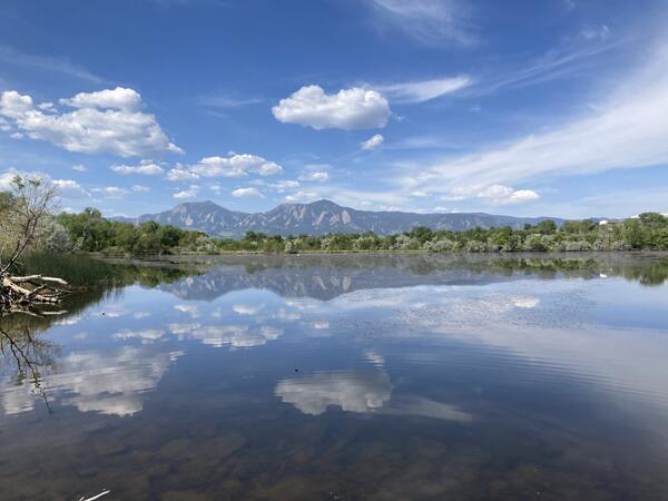
The Colorado Front Range provides an example of these interacting landscapes. Forested uplands provide the majority of water supplies used by both agriculture and rapidly growing urban centers. However, this supply can be threatened by interacting effects of legacy pollutants and landscape disturbances, so understanding the connections between forest and developed land is of high importance.
This project will allow better understanding of how land use and disturbance in one landscape is expressed in water quality of adjacent landscapes. It will shed light on the transfer of contaminants through stream networks and the hypothesized contrasts in mechanisms of mobilization and bioavailability in different parts of the watershed. This understanding is critical not only for the Colorado Front Range, but in many regions across the U.S., where water from forested mountains sustains population and economic growth.
Why this Research is Important: This project addresses critical questions regarding the interactions of land use, water management, and pollutant transport, such as how disturbances remobilize contaminants from historical land use and how that impacts water quality and water availability; how watershed management affects water quality; and how air pollution affects water quality. These questions have important implications for land use development planning, water supplies, and aquatic ecosystems. The work will assist land and water managers in identifying best management practices for our natural resources.
Objective(s): This project seeks to resolve several important questions:
- What are the mechanisms of connection between forested, urban, and agricultural landscapes?
- How does atmospheric deposition of nitrogen, dust, and metals vary in an elevation gradient from urbanized plains to forested mountains?
- How do wildfire, flood, and other extreme events affect water quality and watershed connectivity?
- How do water management and urbanization impact water quality?
Methods: This project involves sampling and analysis of surface water in forested and urban environments to evaluate mechanisms controlling constituent concentrations, measurement of atmospheric deposition of dust, nutrients, and metals across elevational transect (from urban plains to alpine), and sampling and analysis of soil samples along an elevational gradient to determine nutrient availability for plants and microorganisms.
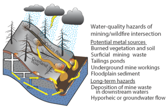
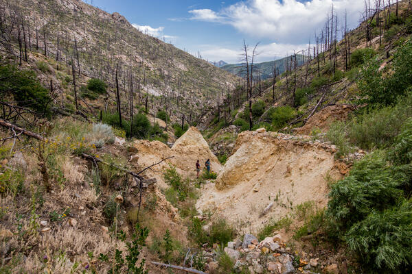
Results: Forested mountains in Colorado deliver high quantity and quality of water to downstream cities and farms, but are vulnerable to disturbances such as wildfire, drought, and flood, which can alter hydrology and water chemistry and have substantial repercussions for downstream waters. This project demonstrated that wildfires can alter hydrology and source availability, leading to increased connectivity of the terrestrial landscape with surface water and conveyance of sediment and nutrients to downstream waters. Additionally, legacy land use can have important implications for post-wildfire water quality; in forests that have regrown in former mining areas, arsenic and metal concentrations may be elevated downstream after wildfire. This project also contributed to national and international assessments of chemistry of ash and ash byproducts.
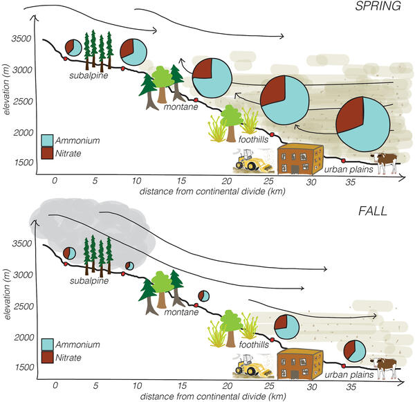
Conversely, activities related to urbanization and agriculture on the lower-elevation plains can affect the forested mountains. Forests adjacent to urban and agricultural areas receive higher deposition of metals and nitrogen than distal areas, and deposition amount is affected by season and weather patterns. Our work showed that atmospheric N deposition in wildfire-prone forests adjacent to the Colorado Front Range urban corridor is twice what previous models predicted, which has important implications for nitrogen cycling after wildfire. The dominant species of nitrogen was ammonium, and a collaboration with university researchers demonstrated that the ammonium was contributed by vehicle emissions, biomass burning, and agriculture. While forested sites nearest to urban and agricultural atmospheric N sources received greater atmospheric deposition of inorganic nitrogen, the microbial community was similar, and a site's capacity to retain or lose N depended on soil characteristics and the ability of the local microbial community to utilize N.
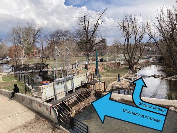
This project identified that hydrologic connectivity is a critical factor in the transfer of nutrients, weathering products, and contaminants between landscapes. Carbon dioxide flux in rivers draining the Colorado Front Range increases, and metabolic processes shifted, during annual snowmelt runoff, a period of greater hydrologic connectivity. As spring runoff decreases, water pathways can transition from shallow subsurface to deeper subsurface flow paths, which leads to elevated weathering products and decreased nutrient concentrations. Seasonal variability in precipitation, flow paths, and other factors is a critical control of dynamic water storage. Water management in semi-arid regions such as the Colorado Front Range substantially alters hydrologic connectivity by reducing local streamflow and moving water through areas that were historically dry, which can have important implications for stream chemistry, particularly in downstream urban areas. Such water diversions can remove microplastics from streams and transfer them to terrestrial landscapes, and thus must be considered in large-scale models of microplastic transfer to the ocean.
Project Impacts: This project serves decision makers and scientists from a local to an international level. Findings have been used by water providers and land managers in planning documents related to source water, stormwater, land management, and ecological restoration. The work informed the Colorado Post-Fire Playbook, which is used by many fire-impacted communities in the west. The project provided scientific expertise, along with real-world field and laboratory opportunities, to over twenty undergraduates, graduate students, and post-doctoral scholars. Products have been presented at international meetings, such as annual meetings of the American Geophysical Union, Geological Society of America, and American Chemical Society.
Downstream communities rely upon forested mountains for high-quality water needed for water supply and agricultural irrigation. However, these forests are vulnerable to disturbances such as wildfire, drought, and flood, and are also affected by air pollution from adjacent urban and agricultural lands. Interactions between forested, urban, and agricultural landscapes can have substantial impacts on water supply and ecology. This project advances understanding of processes that control water, nutrients, and contaminants as Western U.S. streams transition through different landscapes.
Statement of Problem: High-population areas located at the base of mountains often depend on upland forested areas to provide their water supply. These water source areas typically provide a higher quality of water than other land uses. Yet development (such as urbanization and agriculture) in adjacent lowlands can result in interactions that have substantial impacts on water supply and ecology. Forested land disturbances, such as wildfires and floods, can mobilize sediment, nutrients, and contaminants from legacy land use (e.g., arsenic and metals from mining) and transport them downstream to urbanized and agricultural areas, where they are subject to very different in-stream processes. Conversely, atmospheric pollution from urbanized and agricultural areas can be transported to and deposited on upland forests, where disturbances may later remobilize the contaminants.
The Colorado Front Range provides an example of these interacting landscapes. Forested uplands provide the majority of water supplies used by both agriculture and rapidly growing urban centers. However, this supply can be threatened by interacting effects of legacy pollutants and landscape disturbances, so understanding the connections between forest and developed land is of high importance.
This project will allow better understanding of how land use and disturbance in one landscape is expressed in water quality of adjacent landscapes. It will shed light on the transfer of contaminants through stream networks and the hypothesized contrasts in mechanisms of mobilization and bioavailability in different parts of the watershed. This understanding is critical not only for the Colorado Front Range, but in many regions across the U.S., where water from forested mountains sustains population and economic growth.
Why this Research is Important: This project addresses critical questions regarding the interactions of land use, water management, and pollutant transport, such as how disturbances remobilize contaminants from historical land use and how that impacts water quality and water availability; how watershed management affects water quality; and how air pollution affects water quality. These questions have important implications for land use development planning, water supplies, and aquatic ecosystems. The work will assist land and water managers in identifying best management practices for our natural resources.
Objective(s): This project seeks to resolve several important questions:
- What are the mechanisms of connection between forested, urban, and agricultural landscapes?
- How does atmospheric deposition of nitrogen, dust, and metals vary in an elevation gradient from urbanized plains to forested mountains?
- How do wildfire, flood, and other extreme events affect water quality and watershed connectivity?
- How do water management and urbanization impact water quality?
Methods: This project involves sampling and analysis of surface water in forested and urban environments to evaluate mechanisms controlling constituent concentrations, measurement of atmospheric deposition of dust, nutrients, and metals across elevational transect (from urban plains to alpine), and sampling and analysis of soil samples along an elevational gradient to determine nutrient availability for plants and microorganisms.
Results: Forested mountains in Colorado deliver high quantity and quality of water to downstream cities and farms, but are vulnerable to disturbances such as wildfire, drought, and flood, which can alter hydrology and water chemistry and have substantial repercussions for downstream waters. This project demonstrated that wildfires can alter hydrology and source availability, leading to increased connectivity of the terrestrial landscape with surface water and conveyance of sediment and nutrients to downstream waters. Additionally, legacy land use can have important implications for post-wildfire water quality; in forests that have regrown in former mining areas, arsenic and metal concentrations may be elevated downstream after wildfire. This project also contributed to national and international assessments of chemistry of ash and ash byproducts.
Conversely, activities related to urbanization and agriculture on the lower-elevation plains can affect the forested mountains. Forests adjacent to urban and agricultural areas receive higher deposition of metals and nitrogen than distal areas, and deposition amount is affected by season and weather patterns. Our work showed that atmospheric N deposition in wildfire-prone forests adjacent to the Colorado Front Range urban corridor is twice what previous models predicted, which has important implications for nitrogen cycling after wildfire. The dominant species of nitrogen was ammonium, and a collaboration with university researchers demonstrated that the ammonium was contributed by vehicle emissions, biomass burning, and agriculture. While forested sites nearest to urban and agricultural atmospheric N sources received greater atmospheric deposition of inorganic nitrogen, the microbial community was similar, and a site's capacity to retain or lose N depended on soil characteristics and the ability of the local microbial community to utilize N.
This project identified that hydrologic connectivity is a critical factor in the transfer of nutrients, weathering products, and contaminants between landscapes. Carbon dioxide flux in rivers draining the Colorado Front Range increases, and metabolic processes shifted, during annual snowmelt runoff, a period of greater hydrologic connectivity. As spring runoff decreases, water pathways can transition from shallow subsurface to deeper subsurface flow paths, which leads to elevated weathering products and decreased nutrient concentrations. Seasonal variability in precipitation, flow paths, and other factors is a critical control of dynamic water storage. Water management in semi-arid regions such as the Colorado Front Range substantially alters hydrologic connectivity by reducing local streamflow and moving water through areas that were historically dry, which can have important implications for stream chemistry, particularly in downstream urban areas. Such water diversions can remove microplastics from streams and transfer them to terrestrial landscapes, and thus must be considered in large-scale models of microplastic transfer to the ocean.
Project Impacts: This project serves decision makers and scientists from a local to an international level. Findings have been used by water providers and land managers in planning documents related to source water, stormwater, land management, and ecological restoration. The work informed the Colorado Post-Fire Playbook, which is used by many fire-impacted communities in the west. The project provided scientific expertise, along with real-world field and laboratory opportunities, to over twenty undergraduates, graduate students, and post-doctoral scholars. Products have been presented at international meetings, such as annual meetings of the American Geophysical Union, Geological Society of America, and American Chemical Society.