



Scientist with ablation stake on Wolverine Glacier in Alaska. Scientist probes to determine snow depth near another ablation stake.
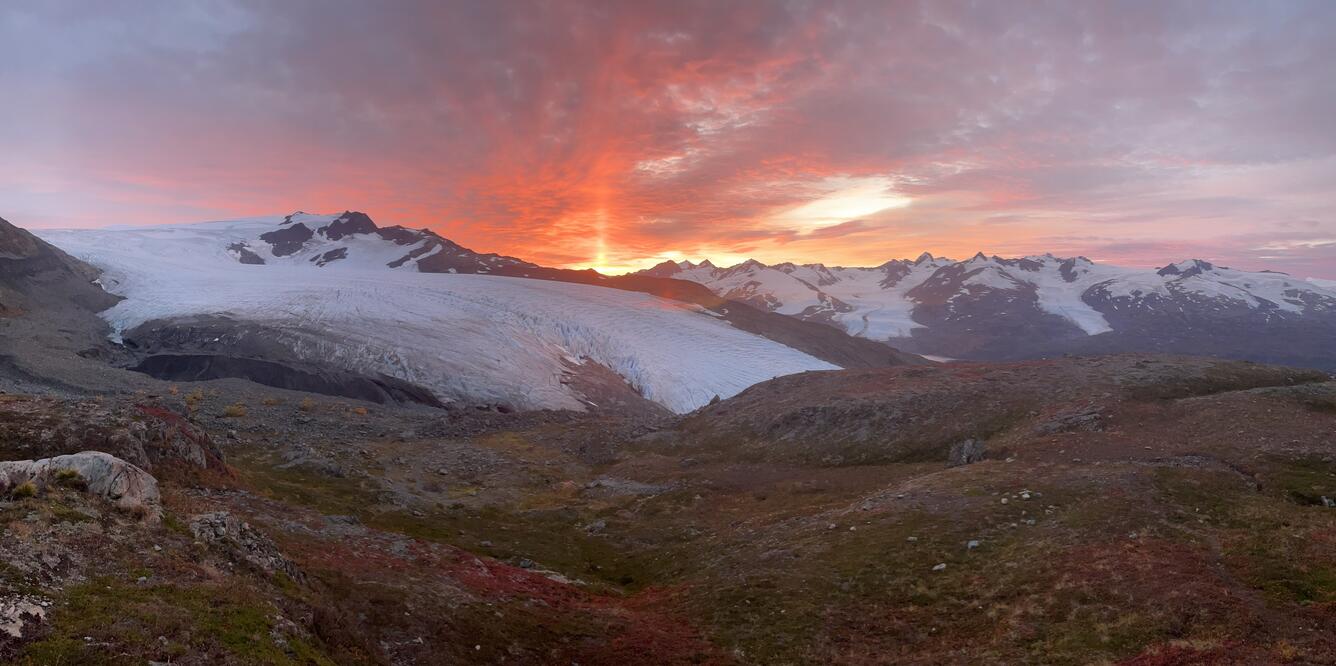
Wolverine Glacier is located in Alaska’s Kenai Mountains, along the western flank of Prince William Sound. Glacier observations began in 1966 and continue through present as the western most USGS Benchmark Glacier.
Return to Glaciers and Landscape Change
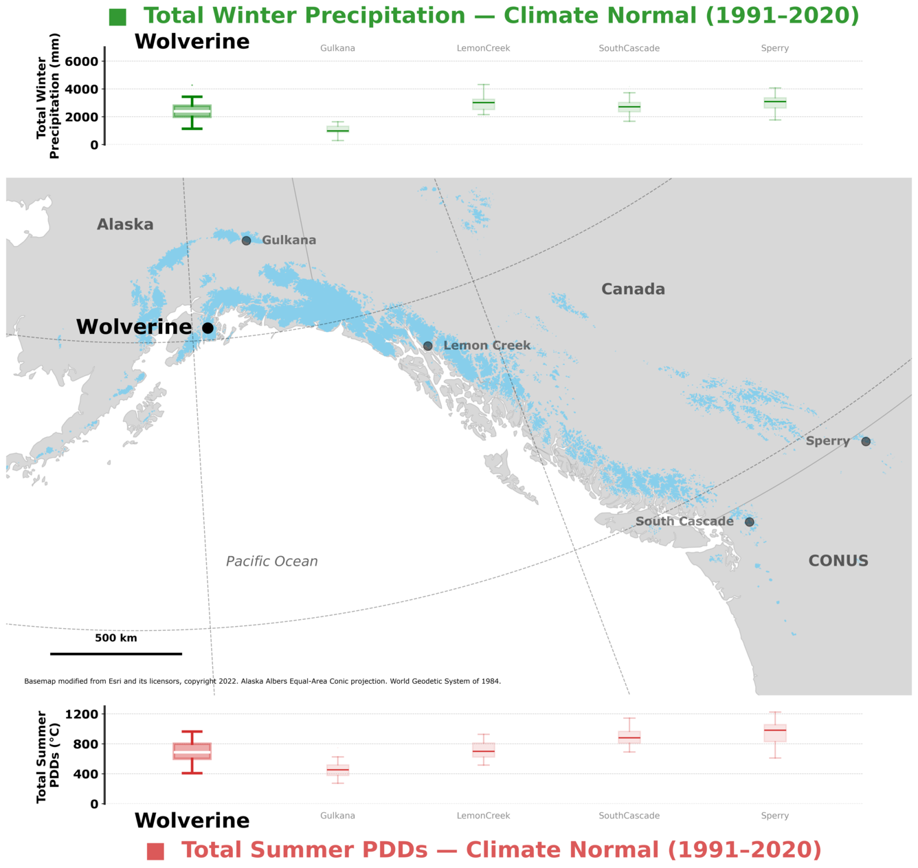
Wolverine Glacier is located in Alaska’s Kenai Mountains, along the western flank of Prince William Sound. The climate is maritime, characterized by both moderate temperatures and precipitation. Wolverine Glacier has a southerly aspect, with a narrow terminus at 1,476 ft (450 m) and a broad accumulation area up to 5,512 ft (1680 m) in elevation. In 2018 the Glacier was approximately 4.3 mi (7 km) long and encompassed an area of 6.0 mi2 (15.6 km2) in its 9.5 mi2 (24.5 km2) basin above a USGS stream gage (O'Neel et al, 2019).
Sources/Usage: Public Domain. View Media Details
Media
Sources/Usage: Public Domain. View Media Details
Glacier Mass Balance
Media
Sources/Usage: Public Domain. View Media Details
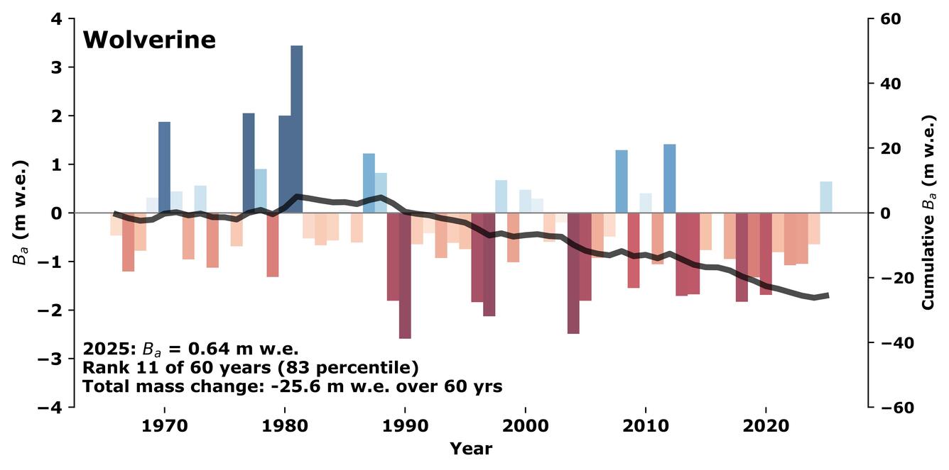
In 1966 as part of the International Hydrological decade, USGS scientists began collecting mass balance, meteorological, and hydrological data at Wolverine Glacier. Today measurements at Wolverine Glacier constitute one of the longest continuous mass balance records in North America, providing insight into snow and ice dynamics, hydrology, and the regional impacts of glacier change.
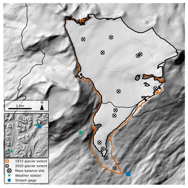
Field visits to measure and maintain metal “ablation” stakes at mass balance sites occur each spring at the onset of the melt season, and again in early autumn near its end. Snow pits or cores are collected to measure the density of material gained or lost. By timing visits near the balance maxima and minima, measurements closely capture maximum winter accumulation and annual balance at each location. Beginning in 1975, additional surveying of mass balance stakes provides both ice velocity and surface elevation change at each site.
From 1966 through the mid-1970's, mass balance studies were relatively extensive, before being reduced to three sites dispersed across the glacier’s elevation. Since 2009, the number of mass balance measurements have increased to improve spatial variability sampling and account for changes to the glacier.
Continuing through today, core tasks involve extensive field measurements now combined with weather data and imagery analysis to calculate seasonal and annual glacier-wide mass balance. These data are published through an official USGS data release and submitted to the World Glacier Monitoring Service. The most recent mass balance results are available on the executive summary webpage. For more detailed description of methods see: O’Neel et al., 2019 and Florentine et al., 2023.
Media
Sources/Usage: Public Domain. View Media Details
Meteorologic
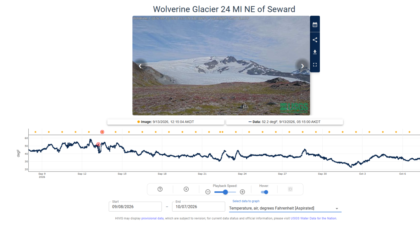
Glacier adjacent meteorological observations began in 1967 with installation of temperature and precipitation instruments. Today the primary station is telemetered with near real-time temperature, relative humidity, precipitation, wind speed and direction data publicly available at the stations Water Data for the Nation webpage.
The Wolverine weather station (60°23' N, 148°55' W) is located at an altitude of 3,248 ft (990 m) on a tundra knoll along the western boundary of the basin. The station is slightly lower than the glacier's average equilibrium line altitude and approximately 1,640 ft (500 m) from the west edge of the glacier. The average annual air temperature at the recorder site is about 30.2°F (-1.0°C), and the average annual precipitation is approximately 43.3 in (1,100 mm). Snowfall is the dominant form of precipitation and usually accumulates on the glacier from September through mid-June. Daily average temperatures range from a low of -14.8°F (-26°C) to a high of 71.6°F (22°C). Daily precipitation catch can be over 4.4 in (113 mm).
Wolverine weather station collects weather data near the glacier to aid mass balance.
Current weather data is available from the Wolverine Glacier 24 MI NE of Seward AK (USGS site 15236895) website and includes:
- Air Temperature
- Relative Humidity
- Wind speed
- Wind Gust Speed
- Wind direction
- Cumulative Precipitation
A telemetered camera on USGS HIVIS, added to the weather station in May 2026, will display and archive once daily daylight images.
Media
Sources/Usage: Public Domain. View Media Details
Ridge-Top Climate Station
An additional weather station has operated intermittently at a higher elevation between 2012 and 2022. The ridge-top weather station (60°24' N, 148°57' W) is ~0.6 miles (1 km) west of the glacier at 4,659 ft (1420 m). Measurements at this site are currently limited to:
- Air Temperature
Hydrologic
The USGS actively maintains a gaging station on Wolverine Creek downstream of the glacier terminus. Surface water data collection and analysis are conducted by standard techniques developed by the USGS. The site is one of nearly 100 surface water stations operated by the USGS in Alaska. Current telemetered data, statistics (annual, daily, and monthly means), and archived historical data can be viewed and downloaded at the water data for the nation website: USGS Monitoring Location 15236900 "Wolverine C NR Lawing AK".
Media

Sources/Usage: Public Domain. View Media Details
Location: Latitude 60°22'14"N., Longitude 148°53'48"W., 1,214 ft (370 m) altitude, in NE 1/4 sec.10, T.3 N., R.3 E., Hydrologic Unit 19020202, on left bank about 0.15 km downstream from terminus of Wolverine Glacier and 15.5mi (25 km) east of Lawing, Alaska.
Drainage area: 9.5 mi2 (24.5 km2)
Period of record: October 1966 to September 1978, October 1980 to September 1981, May 1997 to September 1997, October 2000 to current.
Accuracy: Records are considered fair to poor. The creek bed is composed of poorly sorted gravel and small boulders. The channel is subject to frequent changes during high flows. Large fluctuations from ice melt and alternative damming and storage release during the melt season.
Discharge: Typical summer mean daily discharge ranges between 123.6 cfs (3.5 m3 s-1) and 353.1 cfs (10 m3 s-1) (interquartile range of daily mean values); the period-of-record instantaneous peak discharge was 1,801 cfs (51 m3 s-1) on August 21, 1981 (Benson and others, 1998).
Glaciers and Landscape Change
Mountain glaciers are dynamic reservoirs of frozen water, deeply interconnected with their surrounding ecosystems. Glacier change in North America has major societal impacts, including to water resources, natural hazard risk, tourism disruption, fisheries, and global sea level change. Understanding and quantifying precise connections between changing glaciers, the surrounding landscape and climate...
Filter Total Items: 25

Scientist with ablation stake
Scientist with ablation stake on Wolverine Glacier in Alaska. Scientist probes to determine snow depth near another ablation stake.

Wolverine glacier weather station, Alaska
Wolverine weather station collects weather data near the glacier to aid mass balance. Wolverine Glacier is in the Kenai Mountains on the coast of south-central Alaska. In 1966 scientists with the USGS began making direct measurements of surface mass balance at Wolverine Glacier, one of the "benchmark glaciers" in Alaska.
Wolverine weather station collects weather data near the glacier to aid mass balance. Wolverine Glacier is in the Kenai Mountains on the coast of south-central Alaska. In 1966 scientists with the USGS began making direct measurements of surface mass balance at Wolverine Glacier, one of the "benchmark glaciers" in Alaska.

Wolverine Glacier Ice
Photo of Wolverine Glacier ice. Wolverine Glacier is in the Kenai Mountains on the coast of south-central Alaska. In 1966 scientists with the USGS began making direct measurements of surface mass balance at Wolverine Glacier, a "benchmark glacier" in Alaska.
Photo of Wolverine Glacier ice. Wolverine Glacier is in the Kenai Mountains on the coast of south-central Alaska. In 1966 scientists with the USGS began making direct measurements of surface mass balance at Wolverine Glacier, a "benchmark glacier" in Alaska.

Repeat oblique photographs of Wolverine glacier in Alaska.
Repeat oblique photographs of Wolverine glacier in Alaska.Repeat oblique photographs of Wolverine glacier in Alaska. 1966 image by unknown USGS photographer; 2015 image by L. Sass, USGS.
Repeat oblique photographs of Wolverine glacier in Alaska.
Repeat oblique photographs of Wolverine glacier in Alaska.Repeat oblique photographs of Wolverine glacier in Alaska. 1966 image by unknown USGS photographer; 2015 image by L. Sass, USGS.
Wolverine Glacier is located in Alaska’s Kenai Mountains, along the western flank of Prince William Sound. Glacier observations began in 1966 and continue through present as the western most USGS Benchmark Glacier.
Return to Glaciers and Landscape Change
Wolverine Glacier is located in Alaska’s Kenai Mountains, along the western flank of Prince William Sound. The climate is maritime, characterized by both moderate temperatures and precipitation. Wolverine Glacier has a southerly aspect, with a narrow terminus at 1,476 ft (450 m) and a broad accumulation area up to 5,512 ft (1680 m) in elevation. In 2018 the Glacier was approximately 4.3 mi (7 km) long and encompassed an area of 6.0 mi2 (15.6 km2) in its 9.5 mi2 (24.5 km2) basin above a USGS stream gage (O'Neel et al, 2019).
Sources/Usage: Public Domain. View Media Details
Media
Sources/Usage: Public Domain. View Media Details
Glacier Mass Balance
Media
Sources/Usage: Public Domain. View Media Details
In 1966 as part of the International Hydrological decade, USGS scientists began collecting mass balance, meteorological, and hydrological data at Wolverine Glacier. Today measurements at Wolverine Glacier constitute one of the longest continuous mass balance records in North America, providing insight into snow and ice dynamics, hydrology, and the regional impacts of glacier change.
Field visits to measure and maintain metal “ablation” stakes at mass balance sites occur each spring at the onset of the melt season, and again in early autumn near its end. Snow pits or cores are collected to measure the density of material gained or lost. By timing visits near the balance maxima and minima, measurements closely capture maximum winter accumulation and annual balance at each location. Beginning in 1975, additional surveying of mass balance stakes provides both ice velocity and surface elevation change at each site.
From 1966 through the mid-1970's, mass balance studies were relatively extensive, before being reduced to three sites dispersed across the glacier’s elevation. Since 2009, the number of mass balance measurements have increased to improve spatial variability sampling and account for changes to the glacier.
Continuing through today, core tasks involve extensive field measurements now combined with weather data and imagery analysis to calculate seasonal and annual glacier-wide mass balance. These data are published through an official USGS data release and submitted to the World Glacier Monitoring Service. The most recent mass balance results are available on the executive summary webpage. For more detailed description of methods see: O’Neel et al., 2019 and Florentine et al., 2023.
Media
Sources/Usage: Public Domain. View Media Details
Meteorologic
Glacier adjacent meteorological observations began in 1967 with installation of temperature and precipitation instruments. Today the primary station is telemetered with near real-time temperature, relative humidity, precipitation, wind speed and direction data publicly available at the stations Water Data for the Nation webpage.
The Wolverine weather station (60°23' N, 148°55' W) is located at an altitude of 3,248 ft (990 m) on a tundra knoll along the western boundary of the basin. The station is slightly lower than the glacier's average equilibrium line altitude and approximately 1,640 ft (500 m) from the west edge of the glacier. The average annual air temperature at the recorder site is about 30.2°F (-1.0°C), and the average annual precipitation is approximately 43.3 in (1,100 mm). Snowfall is the dominant form of precipitation and usually accumulates on the glacier from September through mid-June. Daily average temperatures range from a low of -14.8°F (-26°C) to a high of 71.6°F (22°C). Daily precipitation catch can be over 4.4 in (113 mm).
Wolverine weather station collects weather data near the glacier to aid mass balance.
Current weather data is available from the Wolverine Glacier 24 MI NE of Seward AK (USGS site 15236895) website and includes:
- Air Temperature
- Relative Humidity
- Wind speed
- Wind Gust Speed
- Wind direction
- Cumulative Precipitation
A telemetered camera on USGS HIVIS, added to the weather station in May 2026, will display and archive once daily daylight images.
Media
Sources/Usage: Public Domain. View Media Details
Ridge-Top Climate Station
An additional weather station has operated intermittently at a higher elevation between 2012 and 2022. The ridge-top weather station (60°24' N, 148°57' W) is ~0.6 miles (1 km) west of the glacier at 4,659 ft (1420 m). Measurements at this site are currently limited to:
- Air Temperature
Hydrologic
The USGS actively maintains a gaging station on Wolverine Creek downstream of the glacier terminus. Surface water data collection and analysis are conducted by standard techniques developed by the USGS. The site is one of nearly 100 surface water stations operated by the USGS in Alaska. Current telemetered data, statistics (annual, daily, and monthly means), and archived historical data can be viewed and downloaded at the water data for the nation website: USGS Monitoring Location 15236900 "Wolverine C NR Lawing AK".
Media
Sources/Usage: Public Domain. View Media Details
Location: Latitude 60°22'14"N., Longitude 148°53'48"W., 1,214 ft (370 m) altitude, in NE 1/4 sec.10, T.3 N., R.3 E., Hydrologic Unit 19020202, on left bank about 0.15 km downstream from terminus of Wolverine Glacier and 15.5mi (25 km) east of Lawing, Alaska.
Drainage area: 9.5 mi2 (24.5 km2)
Period of record: October 1966 to September 1978, October 1980 to September 1981, May 1997 to September 1997, October 2000 to current.
Accuracy: Records are considered fair to poor. The creek bed is composed of poorly sorted gravel and small boulders. The channel is subject to frequent changes during high flows. Large fluctuations from ice melt and alternative damming and storage release during the melt season.
Discharge: Typical summer mean daily discharge ranges between 123.6 cfs (3.5 m3 s-1) and 353.1 cfs (10 m3 s-1) (interquartile range of daily mean values); the period-of-record instantaneous peak discharge was 1,801 cfs (51 m3 s-1) on August 21, 1981 (Benson and others, 1998).
Glaciers and Landscape Change
Mountain glaciers are dynamic reservoirs of frozen water, deeply interconnected with their surrounding ecosystems. Glacier change in North America has major societal impacts, including to water resources, natural hazard risk, tourism disruption, fisheries, and global sea level change. Understanding and quantifying precise connections between changing glaciers, the surrounding landscape and climate...
Filter Total Items: 25
Scientist with ablation stake
Scientist with ablation stake on Wolverine Glacier in Alaska. Scientist probes to determine snow depth near another ablation stake.
Scientist with ablation stake on Wolverine Glacier in Alaska. Scientist probes to determine snow depth near another ablation stake.
Wolverine glacier weather station, Alaska
Wolverine weather station collects weather data near the glacier to aid mass balance. Wolverine Glacier is in the Kenai Mountains on the coast of south-central Alaska. In 1966 scientists with the USGS began making direct measurements of surface mass balance at Wolverine Glacier, one of the "benchmark glaciers" in Alaska.
Wolverine weather station collects weather data near the glacier to aid mass balance. Wolverine Glacier is in the Kenai Mountains on the coast of south-central Alaska. In 1966 scientists with the USGS began making direct measurements of surface mass balance at Wolverine Glacier, one of the "benchmark glaciers" in Alaska.
Wolverine Glacier Ice
Photo of Wolverine Glacier ice. Wolverine Glacier is in the Kenai Mountains on the coast of south-central Alaska. In 1966 scientists with the USGS began making direct measurements of surface mass balance at Wolverine Glacier, a "benchmark glacier" in Alaska.
Photo of Wolverine Glacier ice. Wolverine Glacier is in the Kenai Mountains on the coast of south-central Alaska. In 1966 scientists with the USGS began making direct measurements of surface mass balance at Wolverine Glacier, a "benchmark glacier" in Alaska.
Repeat oblique photographs of Wolverine glacier in Alaska.
Repeat oblique photographs of Wolverine glacier in Alaska.Repeat oblique photographs of Wolverine glacier in Alaska. 1966 image by unknown USGS photographer; 2015 image by L. Sass, USGS.
Repeat oblique photographs of Wolverine glacier in Alaska.
Repeat oblique photographs of Wolverine glacier in Alaska.Repeat oblique photographs of Wolverine glacier in Alaska. 1966 image by unknown USGS photographer; 2015 image by L. Sass, USGS.