
USGS Sagebrush Science: Supporting Public Safety and Economic Decision Making Across the West
The sagebrush biome is one of the largest ecosystems in North America. Encompassing nearly one-third of the continental U.S., it provides critical resources for millions of Americans and a home for hundreds of plants and animal species in the West.
Natural resource management in sagebrush ecosystems can be complex, and science can support management decisions by providing knowledge and tools to help identify natural resource issues, predict the potential effects of management actions, and devise cost-effective solutions to mitigate adverse impacts.
The USGS Sagebrush Working Group, comprised of dozens of scientists across the agency, is committed to providing actionable science for management partners. On this site, you can learn more about the group’s comprehensive research portfolio and how its science supports public safety and economic decision-making across the West.
Fire and Fuels Management Science
Wildlife Management Science
Land Management Science
About the Sagebrush Working Group
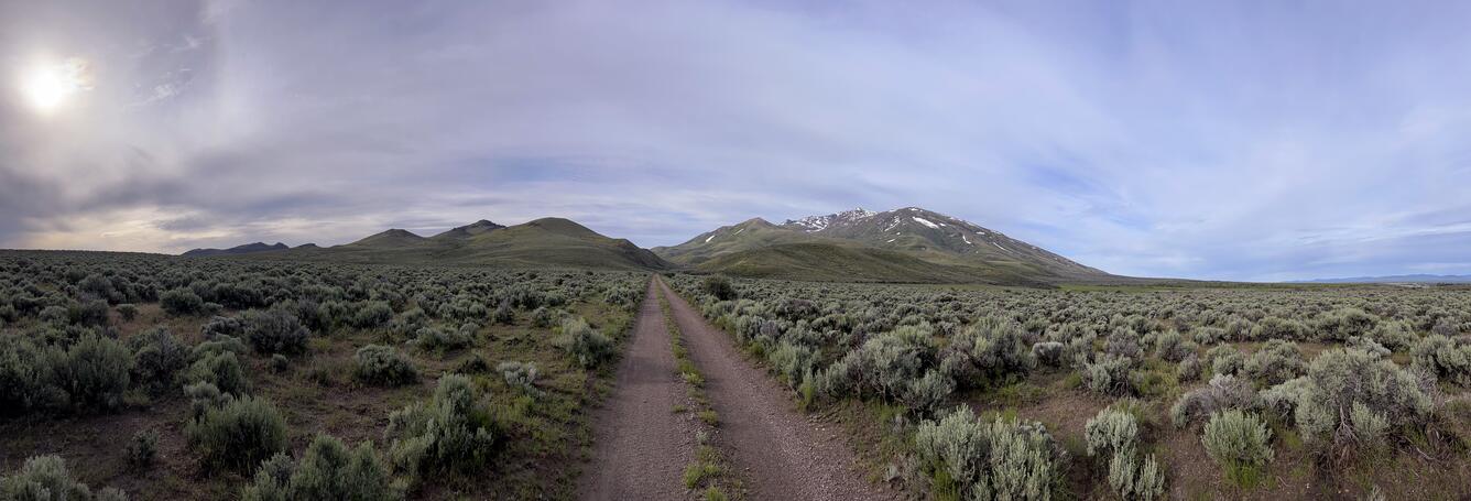
The Sagebrush Biome


Spanning more than 175 million acres, the sagebrush biome is the largest terrestrial ecosystem in the United States.
This primarily shrubland habitat is the ancestral homeland of numerous Tribal Nations and plays a vital role in supporting industries including mining, livestock grazing, energy development, outdoor recreation, and agriculture.
Healthy sagebrush ecosystems provide invaluable services, including flood attenuation and wildfire resistance. The sagebrush biome is also the source of multiple large watersheds that supply drinking water to major cities in the West.
Despite its importance to communities and wildlife, sagebrush is declining at an alarming rate – 1.3 million acres a year is lost to wildfire, development, invading plants, and other causes.
Sagebrush Science for Public Safety and Security
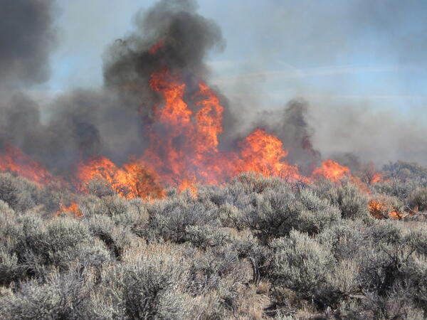
One of the largest threats to sagebrush ecosystems and the communities that depend on them is the increasing prevalence and severity of fires across the West.
Driving this trend is worsening drought in the region and the expansion of nonnative annual grasses that dry up quickly in the summer, dramatically increasing fuels for wildfires.
The Sagebrush Working Group completes cutting-edge research on wildfire and invasive fine fuels to help resource managers protect public safety and security.
Improving Fire and Fuels Management
Sagebrush Working Group scientists research all components of the wildland fire management cycle – from fuels to fire behavior to post-fire restoration methods. Managers can use this information to better estimate the causes and consequences of wildfires and mitigate future risks.
Fuel Break Research
Fuel break science in the Great Basin
Responses to Fuel-Break Treatments in and around Burned Sagebrush Steppe
Ecological trade-offs associated with fuel breaks in sagebrush
Linear fuel breaks in the Sagebrush biome (2020)
Mapping Invasive Grasses
Early Estimates of Exotic Annual Grass in the Sagebrush Biome, 2025
Historic and future trends in exotic annual grass cover in the western US
Causes and Consequences of Invading Grasses
Climate effects on cheatgrass
Invasive Grasses, Wildfire, and Restoration impacts on Carbon Storage in Sagebrush
Potential vectors of invasive annual grasses
Spread and Impact of invasive fuels in Sagebrush
Risk of annual grass invasion following fire in sagebrush
Predicting the phenology of invasive grasses
Managing Invasive Grasses
Seeding and Herbicide Treatment in Sagebrush
Effects of the herbicide, Indaziflam, on invasive annual grasses
The Effect of Pre-Emergent Herbicides on Sagebrush Soils
Longevity of Herbicides Targeting Exotic Annual Grasses in Sagebrush Soils
Assessing invasive annual grass treatment efficacy across the sagebrush biome
Invasive Annual Grass Spatial Dataset Compilation and Synthesis
Fire Behavior & Risk Mitigation
The Wildland Fire Trends Tool
Fire Risk Simulations on National Park Service Lands in Idaho
Sagebrush resistance and resilience to fire
Mitigating parcel-level wildfire risk
Sagebrush wildfire trends and impacts
Livestock grazing as a tool to sustain sagebrush rangelands
Prioritizing Pinyon Juniper Forest Treatments
Post-fire restoration science
Grazing Effects on the Annual Grass Fire-Cycle after Post Fire Management
Sagebrush Steppe Stabilization and Rehabilitation
Predicting Burn Risk to Land Management Investments
Planting and Restoring Functional Sagebrush in Burned Landscapes
Predicting sagebrush recovery using remotely sensed data
Enhancing rangeland recovery by forecasting seed establishment


Partnering with the Department of War
Department of War (DoW) installations and lands across the West face many of the same resource management issues as other public lands in the region. A primary concern for DoW natural resource managers is the increasing risk of wildfire and spread of non-native fuels on military lands. Wildfires not only pose a safety risk to personnel on military lands, but they also have the potential to damage military infrastructure and interfere with military readiness.
Scientists in the Sagebrush Working Group are developing and field-testing several new technologies for the DoW that will be used in supporting wildfire-resilient military bases and surrounding landscapes. Within this program of work, they are closely collaborating with installations across the sagebrush biome to provide managers with science and tools that can improve the effectiveness and durability of management actions on military lands.
Sagebrush Science for Economic Decision Making
Through close collaboration with natural resource management agencies, the Sagebrush Working Group produces science for more efficient and economic decision-making.
Reducing Regulatory Burdens for Wildlife Managers
For decades, researchers in the Sagebrush Working Group have worked closely with wildlife managers to improve wildlife monitoring and management across the biome through rigorous science and cutting-edge tools. Their work promotes the maintenance of healthy fish and game populations and streamlines species management decisions, reducing managers’ financial and regulatory burdens.
Sage-grouse
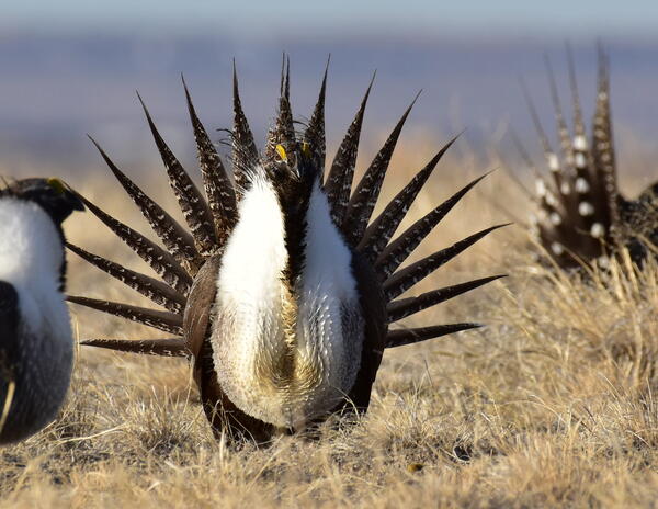
Greater and Gunnison sage-grouse, known for their fascinating mating displays and behavior, are often at the center of land use decisions. Considered good indicators of sagebrush ecosystem health, resource managers are committed to maintaining healthy sage-grouse populations and weighing the potential effects of management actions on sage-grouse.
The Sagebrush Working Group provides managers with cutting-edge tools and science for monitoring and management of this iconic species. Working closely with resource managers, their research has helped keep both sage-grouse species from federal endangered species listing, reducing burdens for wildlife managers across the sagebrush biome.
Greater Sage-Grouse Population Monitoring Framework
Greater Sage-grouse population monitoring framework: Home Page
Targeted Annual Warning System
Population Trends
Web Tool
Sage-Grouse Genetics and Genomics
Genomic resources for the greater sage-grouse
Synthesis of sage-grouse genetic information
Sage-Grouse Habitat Management
range-wide predictive maps of Greater Sage-Grouse seasonal habitats
Future climate and sage-grouse habitats
Gunnison Sage-grouse Habitat Restoration Tool
Conservation Efforts Database: Gunnison sage-grouse Recovery Module
Conifer Encroachment
Pinyon-Juniper Disturbance Effects on Wildlife
Songbird Density-Habitat Relationships within pinyon-juniper and sagebrush ecosystems
prioritizing conifer removal for multi-species outcomes
Annotated Bibliographies
Annotated Bibliographies for resource managers
Science for Resource Managers Bibliography Search Tool
Wild Horses and Burros
Wild horse and burro populations can grow rapidly if not properly managed, reducing rangeland quality for livestock and native wildlife. Researchers in the Sagebrush Working Group produce tools and techniques to improve population estimates of free-roaming horse and burro populations across the West. They work closely with horse and burro managers to develop reliable count methods, including non-invasive genetic techniques, and simulate potential population change under different management scenarios.
They are also using historical wild horse survey and monitoring records to estimate horse density across the biome and evaluate the relative influence of horse abundance and livestock grazing on components of ecosystem health and other wildlife. Results can help managers refine and validate Appropriate Management Levels in horse and burro management areas.
Native Ungulates
Researchers in the Sagebrush Working Group have paved the way for mapping of ungulate migrations across the West, making it easier for managers to determine how management actions may potentially impact elk, deer, moose, and pronghorn populations and their habitats. Researchers also work closely with National Parks to understand the population status and trends of bighorn sheep and mountain goats.
Ungulate research groups also work with wildlife managers to study Chronic Wasting Disease (CWD), including studies on the effects of elk and mule deer management practices on the spread of this deadly disease:
Chronic Wasting Disease Research in the Northern Rockies
Chronic Wasting Disease Research at the National Elk Refuge
Modeling chronic wasting disease prevalence through time
Other Wildlife
The Sagebrush Working Group is also responsible for research on insects, reptiles, amphibians, small mammals, songbirds, and other wildlife in response to management needs. Explore some of these studies:
Wildlife Ecology and Conservation in the Intermountain West and Great Basin
Western Bumble Bee and Native Pollinator Research
Modeling future distributions of lizards and snakes in the West
Wildlife Research in Southwestern Wyoming
Wildlife-Habitat relationships
Large mammal behavior
Sagebrush songbirds
Amphibian disease
Facilitating Streamlined, Effective Land Management
The Sagebrush Working Group develops innovative science and state-of-the-art tools for resource managers, to ensure decision making is timely and effective.
Synthesizing science for public lands management
Scientists in the Sagebrush Working Group work closely with resource managers to synthesize science about priority management issues on public lands. They have also developed a new suite of products known as structured science syntheses that are organized to align with relevant decision-making processes and designed for ease of use.
Ultimately, the aim of all syntheses is to assist managers in making speedy and defensible decisions on public lands. Published science syntheses include science that can streamline management of oil and gas development, nonmotorized recreation, culvert construction, and invasive grass management.
Improving the economic efficiency of land management
Economists in the Sagebrush Working Group collaborate with scientists and land managers to estimate the costs of different public land treatments, including invasive grass treatments, post-fire restoration methods, and prescribed burns. These cost analyses can assist resource managers in estimating land treatment costs across many different contexts and weighing potential costs and benefits in their decision making
Supporting responsible development in southwestern Wyoming
Southwestern Wyoming is an area rich in natural resources, including significant energy reserves, critical minerals, and large swaths of intact sagebrush habitat. In 2007, the Wyoming Landscape Conservation Initiative (WLCI) – a coalition of local, State and Federal governments, private companies, and public citizens – formed with the mission to facilitate reliable energy development, mining, outdoor recreation and agriculture in the region, while enhancing aquatic and terrestrial habitats across southwestern Wyoming. Since 2007, USGS has provided much needed research and mapping capabilities as a main partner in this initiative.
Providing baseline vegetation data for rangeland management
The Rangeland Condition Monitoring, Assessment, and Projection (RCMAP) project provides natural resource managers with satellite-based maps of vegetation cover conditions over the last 40 years. Managers can use these maps to monitor the condition and trends of rangelands over time.
Modeling future distributions of pinyon-juniper woodland species

Scientists used a suite of dryland-focused environmental variables to predict future distributions of nine pinyon-juniper woodland species under varying temperature and precipitation scenarios.
Managers can explore these projections through an interactive application.
Assessing and informing management effectiveness
Multiple decision support science tools and projects from the Sagebrush Working Group assist land managers with evaluating and predicting the efficacy of management actions.
Land Treatment Digital Library and Exploration Tool
The Land Treatment Digital Library (LTDL) is an online catalog of legacy land treatment information carried out on Bureau of Land Management lands in the western United States. The LTDL compiles different types of land treatments, such as seedings, vegetation removals, and prescribed fire - and is used by land managers to help them make decisions about where, when, and how to implement future land treatments using the Land Treatment Exploration Tool (LTET). The LTDL houses information on over 70,000 treatments on BLM lands across the western United States.
About the Land Treatment Digital Library (LTDL)
About the Land Treatment Exploration Tool (LTET)
LTDL in action
Oregon Rangeland Monitoring Program
Assessing Ecosystem Health and the Efficacy of Management Actions
Rapid and Other Methods for Assessment and Monitoring (ROAM)
Restoration Assessment and Monitoring Program for the Southwest (RAMPS)
SageSTEP: Sagebrush steppe treatment evaluation project
Understanding the future of sagebrush ecological integrity
Fire, Invasives, and Rehabilitation of Shrub Steppe (FIREss) Team
Projections of Sagebrush Ecological Integrity
WebDART: An online ecological assessment tool
The Conservation Efforts Database
Indicators of Rangeland Health
Prioritizing Restoration of Sagebrush Ecosystems Tool
Predicting sagebrush recovery
About the Sagebrush Working Group
The USGS Sagebrush Working Group, coordinated by the USGS Land Management Research Program, includes over 50 scientists from a range of USGS centers, programs, regions, mission areas, and cooperative units. Decades of experience investigating and developing solutions for natural resource management issues in sagebrush ecosystems have made the group a go-to resource for partners.
Researchers in the Sagebrush Working Group frequently partner with federal agencies, including the Department of War, Bureau of Land Management, Fish and Wildlife Service, and National Park Service, to identify priority science needs and support adaptive management of public lands. They also work closely with state natural resource agencies, Tribal governments, and nongovernmental organizations to ensure local communities have high-quality science and tools to make decisions for themselves.
Finally, they contribute expertise to large, collaborative projects that inform decision making across the biome. Scientists from the Sagebrush Working Group were crucial to the development of the Sagebrush Conservation Design, a range-wide, spatially explicit tool to identify the remaining healthy, intact sagebrush core landscapes and opportunity areas for their growth. They were also a large part of the Western Association of Fish and Wildlife Agencies Sagebrush Conservation Strategy, a strategy intended to guide conservation efforts across the sagebrush biome to benefit the people and wildlife that depend on it.
Title
Where We Work
Researchers in the Sagebrush Working Group are located throughout the sagebrush biome. Explore points on the map to learn more about contributing USGS centers.

The sagebrush biome is one of the largest ecosystems in North America. Encompassing nearly one-third of the continental U.S., it provides critical resources for millions of Americans and a home for hundreds of plants and animal species in the West.
Natural resource management in sagebrush ecosystems can be complex, and science can support management decisions by providing knowledge and tools to help identify natural resource issues, predict the potential effects of management actions, and devise cost-effective solutions to mitigate adverse impacts.
The USGS Sagebrush Working Group, comprised of dozens of scientists across the agency, is committed to providing actionable science for management partners. On this site, you can learn more about the group’s comprehensive research portfolio and how its science supports public safety and economic decision-making across the West.
Fire and Fuels Management Science
Wildlife Management Science
Land Management Science
About the Sagebrush Working Group
The Sagebrush Biome
Spanning more than 175 million acres, the sagebrush biome is the largest terrestrial ecosystem in the United States.
This primarily shrubland habitat is the ancestral homeland of numerous Tribal Nations and plays a vital role in supporting industries including mining, livestock grazing, energy development, outdoor recreation, and agriculture.
Healthy sagebrush ecosystems provide invaluable services, including flood attenuation and wildfire resistance. The sagebrush biome is also the source of multiple large watersheds that supply drinking water to major cities in the West.
Despite its importance to communities and wildlife, sagebrush is declining at an alarming rate – 1.3 million acres a year is lost to wildfire, development, invading plants, and other causes.
Sagebrush Science for Public Safety and Security
One of the largest threats to sagebrush ecosystems and the communities that depend on them is the increasing prevalence and severity of fires across the West.
Driving this trend is worsening drought in the region and the expansion of nonnative annual grasses that dry up quickly in the summer, dramatically increasing fuels for wildfires.
The Sagebrush Working Group completes cutting-edge research on wildfire and invasive fine fuels to help resource managers protect public safety and security.
Improving Fire and Fuels Management
Sagebrush Working Group scientists research all components of the wildland fire management cycle – from fuels to fire behavior to post-fire restoration methods. Managers can use this information to better estimate the causes and consequences of wildfires and mitigate future risks.
Fuel Break Research
Fuel break science in the Great Basin
Responses to Fuel-Break Treatments in and around Burned Sagebrush Steppe
Ecological trade-offs associated with fuel breaks in sagebrush
Linear fuel breaks in the Sagebrush biome (2020)
Mapping Invasive Grasses
Early Estimates of Exotic Annual Grass in the Sagebrush Biome, 2025
Historic and future trends in exotic annual grass cover in the western US
Causes and Consequences of Invading Grasses
Climate effects on cheatgrass
Invasive Grasses, Wildfire, and Restoration impacts on Carbon Storage in Sagebrush
Potential vectors of invasive annual grasses
Spread and Impact of invasive fuels in Sagebrush
Risk of annual grass invasion following fire in sagebrush
Predicting the phenology of invasive grasses
Managing Invasive Grasses
Seeding and Herbicide Treatment in Sagebrush
Effects of the herbicide, Indaziflam, on invasive annual grasses
The Effect of Pre-Emergent Herbicides on Sagebrush Soils
Longevity of Herbicides Targeting Exotic Annual Grasses in Sagebrush Soils
Assessing invasive annual grass treatment efficacy across the sagebrush biome
Invasive Annual Grass Spatial Dataset Compilation and Synthesis
Fire Behavior & Risk Mitigation
The Wildland Fire Trends Tool
Fire Risk Simulations on National Park Service Lands in Idaho
Sagebrush resistance and resilience to fire
Mitigating parcel-level wildfire risk
Sagebrush wildfire trends and impacts
Livestock grazing as a tool to sustain sagebrush rangelands
Prioritizing Pinyon Juniper Forest Treatments
Post-fire restoration science
Grazing Effects on the Annual Grass Fire-Cycle after Post Fire Management
Sagebrush Steppe Stabilization and Rehabilitation
Predicting Burn Risk to Land Management Investments
Planting and Restoring Functional Sagebrush in Burned Landscapes
Predicting sagebrush recovery using remotely sensed data
Enhancing rangeland recovery by forecasting seed establishment
Partnering with the Department of War
Department of War (DoW) installations and lands across the West face many of the same resource management issues as other public lands in the region. A primary concern for DoW natural resource managers is the increasing risk of wildfire and spread of non-native fuels on military lands. Wildfires not only pose a safety risk to personnel on military lands, but they also have the potential to damage military infrastructure and interfere with military readiness.
Scientists in the Sagebrush Working Group are developing and field-testing several new technologies for the DoW that will be used in supporting wildfire-resilient military bases and surrounding landscapes. Within this program of work, they are closely collaborating with installations across the sagebrush biome to provide managers with science and tools that can improve the effectiveness and durability of management actions on military lands.
Sagebrush Science for Economic Decision Making
Through close collaboration with natural resource management agencies, the Sagebrush Working Group produces science for more efficient and economic decision-making.
Reducing Regulatory Burdens for Wildlife Managers
For decades, researchers in the Sagebrush Working Group have worked closely with wildlife managers to improve wildlife monitoring and management across the biome through rigorous science and cutting-edge tools. Their work promotes the maintenance of healthy fish and game populations and streamlines species management decisions, reducing managers’ financial and regulatory burdens.
Sage-grouse
Greater and Gunnison sage-grouse, known for their fascinating mating displays and behavior, are often at the center of land use decisions. Considered good indicators of sagebrush ecosystem health, resource managers are committed to maintaining healthy sage-grouse populations and weighing the potential effects of management actions on sage-grouse.
The Sagebrush Working Group provides managers with cutting-edge tools and science for monitoring and management of this iconic species. Working closely with resource managers, their research has helped keep both sage-grouse species from federal endangered species listing, reducing burdens for wildlife managers across the sagebrush biome.
Greater Sage-Grouse Population Monitoring Framework
Greater Sage-grouse population monitoring framework: Home Page
Targeted Annual Warning System
Population Trends
Web Tool
Sage-Grouse Genetics and Genomics
Genomic resources for the greater sage-grouse
Synthesis of sage-grouse genetic information
Sage-Grouse Habitat Management
range-wide predictive maps of Greater Sage-Grouse seasonal habitats
Future climate and sage-grouse habitats
Gunnison Sage-grouse Habitat Restoration Tool
Conservation Efforts Database: Gunnison sage-grouse Recovery Module
Conifer Encroachment
Pinyon-Juniper Disturbance Effects on Wildlife
Songbird Density-Habitat Relationships within pinyon-juniper and sagebrush ecosystems
prioritizing conifer removal for multi-species outcomes
Annotated Bibliographies
Annotated Bibliographies for resource managers
Science for Resource Managers Bibliography Search Tool
Wild Horses and Burros
Wild horse and burro populations can grow rapidly if not properly managed, reducing rangeland quality for livestock and native wildlife. Researchers in the Sagebrush Working Group produce tools and techniques to improve population estimates of free-roaming horse and burro populations across the West. They work closely with horse and burro managers to develop reliable count methods, including non-invasive genetic techniques, and simulate potential population change under different management scenarios.
They are also using historical wild horse survey and monitoring records to estimate horse density across the biome and evaluate the relative influence of horse abundance and livestock grazing on components of ecosystem health and other wildlife. Results can help managers refine and validate Appropriate Management Levels in horse and burro management areas.
Native Ungulates
Researchers in the Sagebrush Working Group have paved the way for mapping of ungulate migrations across the West, making it easier for managers to determine how management actions may potentially impact elk, deer, moose, and pronghorn populations and their habitats. Researchers also work closely with National Parks to understand the population status and trends of bighorn sheep and mountain goats.
Ungulate research groups also work with wildlife managers to study Chronic Wasting Disease (CWD), including studies on the effects of elk and mule deer management practices on the spread of this deadly disease:
Chronic Wasting Disease Research in the Northern Rockies
Chronic Wasting Disease Research at the National Elk Refuge
Modeling chronic wasting disease prevalence through time
Other Wildlife
The Sagebrush Working Group is also responsible for research on insects, reptiles, amphibians, small mammals, songbirds, and other wildlife in response to management needs. Explore some of these studies:
Wildlife Ecology and Conservation in the Intermountain West and Great Basin
Western Bumble Bee and Native Pollinator Research
Modeling future distributions of lizards and snakes in the West
Wildlife Research in Southwestern Wyoming
Wildlife-Habitat relationships
Large mammal behavior
Sagebrush songbirds
Amphibian disease
Facilitating Streamlined, Effective Land Management
The Sagebrush Working Group develops innovative science and state-of-the-art tools for resource managers, to ensure decision making is timely and effective.
Synthesizing science for public lands management
Scientists in the Sagebrush Working Group work closely with resource managers to synthesize science about priority management issues on public lands. They have also developed a new suite of products known as structured science syntheses that are organized to align with relevant decision-making processes and designed for ease of use.
Ultimately, the aim of all syntheses is to assist managers in making speedy and defensible decisions on public lands. Published science syntheses include science that can streamline management of oil and gas development, nonmotorized recreation, culvert construction, and invasive grass management.
Improving the economic efficiency of land management
Economists in the Sagebrush Working Group collaborate with scientists and land managers to estimate the costs of different public land treatments, including invasive grass treatments, post-fire restoration methods, and prescribed burns. These cost analyses can assist resource managers in estimating land treatment costs across many different contexts and weighing potential costs and benefits in their decision making
Supporting responsible development in southwestern Wyoming
Southwestern Wyoming is an area rich in natural resources, including significant energy reserves, critical minerals, and large swaths of intact sagebrush habitat. In 2007, the Wyoming Landscape Conservation Initiative (WLCI) – a coalition of local, State and Federal governments, private companies, and public citizens – formed with the mission to facilitate reliable energy development, mining, outdoor recreation and agriculture in the region, while enhancing aquatic and terrestrial habitats across southwestern Wyoming. Since 2007, USGS has provided much needed research and mapping capabilities as a main partner in this initiative.
Providing baseline vegetation data for rangeland management
The Rangeland Condition Monitoring, Assessment, and Projection (RCMAP) project provides natural resource managers with satellite-based maps of vegetation cover conditions over the last 40 years. Managers can use these maps to monitor the condition and trends of rangelands over time.
Modeling future distributions of pinyon-juniper woodland species
Scientists used a suite of dryland-focused environmental variables to predict future distributions of nine pinyon-juniper woodland species under varying temperature and precipitation scenarios.
Managers can explore these projections through an interactive application.
Assessing and informing management effectiveness
Multiple decision support science tools and projects from the Sagebrush Working Group assist land managers with evaluating and predicting the efficacy of management actions.
Land Treatment Digital Library and Exploration Tool
The Land Treatment Digital Library (LTDL) is an online catalog of legacy land treatment information carried out on Bureau of Land Management lands in the western United States. The LTDL compiles different types of land treatments, such as seedings, vegetation removals, and prescribed fire - and is used by land managers to help them make decisions about where, when, and how to implement future land treatments using the Land Treatment Exploration Tool (LTET). The LTDL houses information on over 70,000 treatments on BLM lands across the western United States.
About the Land Treatment Digital Library (LTDL)
About the Land Treatment Exploration Tool (LTET)
LTDL in action
Oregon Rangeland Monitoring Program
Assessing Ecosystem Health and the Efficacy of Management Actions
Rapid and Other Methods for Assessment and Monitoring (ROAM)
Restoration Assessment and Monitoring Program for the Southwest (RAMPS)
SageSTEP: Sagebrush steppe treatment evaluation project
Understanding the future of sagebrush ecological integrity
Fire, Invasives, and Rehabilitation of Shrub Steppe (FIREss) Team
Projections of Sagebrush Ecological Integrity
WebDART: An online ecological assessment tool
The Conservation Efforts Database
Indicators of Rangeland Health
Prioritizing Restoration of Sagebrush Ecosystems Tool
Predicting sagebrush recovery
About the Sagebrush Working Group
The USGS Sagebrush Working Group, coordinated by the USGS Land Management Research Program, includes over 50 scientists from a range of USGS centers, programs, regions, mission areas, and cooperative units. Decades of experience investigating and developing solutions for natural resource management issues in sagebrush ecosystems have made the group a go-to resource for partners.
Researchers in the Sagebrush Working Group frequently partner with federal agencies, including the Department of War, Bureau of Land Management, Fish and Wildlife Service, and National Park Service, to identify priority science needs and support adaptive management of public lands. They also work closely with state natural resource agencies, Tribal governments, and nongovernmental organizations to ensure local communities have high-quality science and tools to make decisions for themselves.
Finally, they contribute expertise to large, collaborative projects that inform decision making across the biome. Scientists from the Sagebrush Working Group were crucial to the development of the Sagebrush Conservation Design, a range-wide, spatially explicit tool to identify the remaining healthy, intact sagebrush core landscapes and opportunity areas for their growth. They were also a large part of the Western Association of Fish and Wildlife Agencies Sagebrush Conservation Strategy, a strategy intended to guide conservation efforts across the sagebrush biome to benefit the people and wildlife that depend on it.
Title
Where We Work
Researchers in the Sagebrush Working Group are located throughout the sagebrush biome. Explore points on the map to learn more about contributing USGS centers.