
Wyoming Landscape Conservation Initiative (WLCI) research at NOROCK
The Wyoming Landscape Conservation Initiative (WLCI) addresses the impacts of land-use and habitat changes on Southwest Wyoming’s natural resources. This long-term project involves partners from 12 Federal, State, and local natural resource agencies, as well as non-governmental organizations. NOROCK scientists, partners, and scientists from other USGS centers conduct integrated research to support habitat management decisions, development planning, and trade-offs among wildlife, rural economies, and multiple land-use priorities. The projects highlighted on this page provide information on sagebrush ecosystem vegetation management, mule deer, pronghorn, and pollinators, offering resource managers tools to enhance the terrestrial habitats and the economy of Southwest Wyoming.
Mule Deer
Mule deer play important ecological roles by influencing vegetation communities, nutrient cycling, and serving as prey for large predators. They also have cultural significance and support local and regional economies as a game species. Wildlife managers seek to support mule deer in Wyoming because populations have declined across much of the West (WAFWA 2025), which can reduce hunting opportunities and associated economic benefits. However, multiple, interacting factors complicate their management. For example, development, disease, and drought can affect mule deer habitat selection, migration, and survival (Pierce et al. 2012, Sawyer et al. 2017, Northrup et al., 2021, Aikens et al. 2020, Moss et al. 2025). USGS NOROCK works with Federal and State partners to provide unbiased scientific information and tools to guide mule deer management in Wyoming, supporting the communities that rely on this important species.
Assessing effects of energy development, climate, landcover, and restoration on mule deer winter use areas to sustain declining populations

We evaluated how the ratio of juvenile to adult female mule deer—a measure of population growth—was affected by forage availability, habitat composition, winter severity, energy development, predation, wildfire, and habitat restoration on winter use areas over 40 years and across 37 herd units in Wyoming. Scientists assessed how these conditions have changed over time and how widespread changes in winter use areas, including drought and severe winters, constrain decision options of managers to sustain mule deer populations. This study will provide a long-term, multi-scale perspective on the main drivers of mule deer declines in Wyoming, helping wildlife managers focus on actionable strategies to support the long-term sustainability of this economically valuable big game species. The project supports Secretarial Order 3362, which has the goals of improving winter range and migration corridor habitat on Federal lands for big-game species like mule deer, elk, and pronghorn.
USGS Investigators: Tabitha Graves (NOROCK), Will Janousek (NOROCK), Aaron Johnston (NOROCK), Blake Lowrey (NOROCK), Matt Kauffman (WY Coop)
Collaborators: Bureau of Land Management, Wyoming Game and Fish Department, University of Wyoming, Wyoming Landscape Conservation Initiative
Linking multi-season habitat quality with changes in juvenile mule deer abundance across Wyoming
Mule deer are distributed across Wyoming and live in a wide range of ecosystems. Different populations face varying pressures, making management strategies challenging to develop. The USGS and its collaborators are using GPS collar data from over 1,400 Wyoming mule deer to create mapping tools that help managers prioritize habitat restoration locations. Scientists evaluated the relative influence of habitat on summer and winter ranges on juvenile mule deer abundance changes considering drought, severe winters, and other stressors. This research will also lead to data needed to develop a decision support tool that will streamline collaborator decisions related to siting habitat improvements and conservation planning for big game conservation and management. This project supports Secretarial Order 3362, which has the goals of improving winter range and migration corridor habitat on Federal lands for big-game species like mule deer, elk, and pronghorn.
USGS Investigators: Tabitha Graves (NOROCK), Will Janousek (NOROCK), Aaron Johnston (NOROCK), Blake Lowrey (NOROCK), Matt Kauffman (WY Coop Research Unit)
Collaborators: Bureau of Land Management, Wyoming Game and Fish Department, University of Wyoming, Wyoming Landscape Conservation Initiative
Mapping for cumulative effects assessments on big game in Wyoming

Ungulates (hoofed mammals) like mule deer face increasing pressure from development, drought, and disease. Wildlife managers are often tasked with measuring how new development projects affect ungulate species that require permit decisions. Understanding these impacts on the ungulate population requires considering the broader landscape, including surrounding habitat, developments, and activities. Assessing these combined effects helps determine how much a new action might influence the species of concern. To provide the best available science to wildlife managers and support their cumulative effects assessments of big game in Wyoming, NOROCK scientists are planning on mapping the effects of land-use change on mule deer, whose populations are in decline. This work supports Secretarial Order 3418—unleashing American Energy.
USGS Investigators: Tabitha Graves (NOROCK), Will Janousek (NOROCK), Aaron Johnston (NOROCK)
Collaborators: Bureau of Land Management, Wyoming Game and Fish Department, Wyoming Landscape Conservation Initiative
Effectiveness of habitat treatments for improving wildlife habitat
Habitat treatments in sagebrush and aspen ecosystems are critical management actions to improve habitat quality for wildlife and to enhance the resilience of these communities to stressors like drought. Prescribed fire, herbicide, and mechanical treatments are applied extensively throughout Southwest Wyoming, often with increasingly specific prescriptions to support target species including sage-grouse, mule deer, and elk. Measuring treatment effectiveness and understanding factors that influence treatment outcomes are essential for adaptive management and maximizing the efficiency of these costly management actions. USGS scientists quantified changes in vegetation productivity, phenology, and cover following different treatments using ground-based data and satellite-derived vegetation indices. Current research focuses on 1) understanding mule deer responses to management treatments and 2) comparing satellite and ground-based evaluations of treatment effectiveness to optimize treatment planning. These studies directly support Secretarial Order 3362 by evaluating the effectiveness of habitat treatments for big game species.
USGS Investigators: Aaron Johnston (NOROCK), Tabitha Graves (NOROCK), Matt Kauffman (WY Coop)
Collaborators: Bureau of Land Management, Wyoming Game and Fish Department, University of Wyoming, Wyoming Landscape Conservation Initiative
Pronghorn
Pronghorn responses to wind energy development

Pronghorn are economically, culturally, and ecologically important, with over 50% of their historical habitat located in Wyoming. Wind energy development has increased rapidly in the state, with several existing and planned facilities occurring in crucial pronghorn ranges. In 2018, Wyoming Game and Fish Department and the USGS Wyoming Cooperative Research Unit began a 6-year study to track pronghorn using GPS collars at both new and existing wind facilities, motivated by concerns about impacts on Wyoming’s largest pronghorn population. These data capture pronghorn movements before, during, and after construction of TB Flats and Ekola Flats, alongside existing facilities (Dunlap, Seven Mile), providing an unprecedented assessment of pronghorn responses to wind development. Scientists used these data to evaluate the effects of wind facilities on pronghorn behavior and habitat use during summer, winter, and seasonal migrations. Current research focuses on changes in pronghorn survival and migration decisions in the presence of wind facilities. This research fills critical information gaps on pronghorn responses to wind energy facilities and can inform the siting, construction, and operation of wind facilities, including several proposed near Medicine Bow, Wyoming. This study supports Secretarial Order 3362 by advancing understanding of seasonal ranges and migratory movements of pronghorn.
USGS Investigators: Aaron Johnston (NOROCK), Tabitha Graves (NOROCK), Blake Lowrey (NOROCK), Matt Kauffman (WY Coop)
Collaborators: Wyoming Game and Fish Department, University of Wyoming, Wyoming Landscape Conservation Initiative
Ungulate Migration Mapping
Mapping ungulate migration corridors in the western U.S.
Seasonal migration is a common and important behavior that helps maintain ungulate populations by enabling individuals to track seasonally variable resources or avoid threats like predation and heavy snow. In 2018, the USGS initiated the Corridor Mapping Team, a collaborative group of State, Federal, Tribal, and university researchers and biologists that map ungulate migrations across western U.S. states. The Corridor Mapping Team informs the understanding of economically valuable migratory ungulates (mule deer, white-tailed deer, elk, pronghorn, moose, bison) across Wyoming and the western U.S. They work in close cooperation with State and Tribal wildlife agencies to develop and publish maps and online mapping tools related to ungulate movement or land use and their products can be used to avoid or limit energy development-wildlife conflicts. This project supports Secretarial Order 3362 and improves decision-making and streamlines implementation of Secretarial Order 3418—Unleashing American Energy.
USGS Investigators: Blake Lowrey (NOROCK), Matt Kauffman (WY Coop)
Collaborators: Bureau of Land Management, University of Wyoming, Wyoming Landscape Conservation Initiative
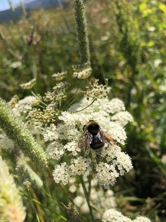
Pollinators
Western bumblebee map
Pollinators are declining worldwide, and bumblebees are no exception (Potts et al. 2010). The Western bumblebee, once one of the most widespread bumblebees across the western U.S. and Canada, has experienced a dramatic range decline, as shown by a NOROCK-led collaboration (Janousek et al. 2023). NOROCK scientists developed a map to inform local and regional managers about where the Western bumblebee is most likely to occur. This tool helps managers support healthy pollinator populations and minimize conflicts when multiple management goals exist. Together with other science products that assess species status and trends, this mapping tool can be used to inform biological assessments and environmental reviews, including those focused on pollinators—species that provide essential services important for wildlife, human food security, and agricultural economies.
USGS Investigators: Tabitha Graves (NOROCK), Will Janousek (NOROCK)
Collaborators: U.S. Fish and Wildlife Service, Bureau of Land Management, Wyoming Landscape Conservation Initiative
The Wyoming Landscape Conservation Initiative (WLCI) addresses the impacts of land-use and habitat changes on Southwest Wyoming’s natural resources. This long-term project involves partners from 12 Federal, State, and local natural resource agencies, as well as non-governmental organizations. NOROCK scientists, partners, and scientists from other USGS centers conduct integrated research to support habitat management decisions, development planning, and trade-offs among wildlife, rural economies, and multiple land-use priorities. The projects highlighted on this page provide information on sagebrush ecosystem vegetation management, mule deer, pronghorn, and pollinators, offering resource managers tools to enhance the terrestrial habitats and the economy of Southwest Wyoming.
Mule Deer
Mule deer play important ecological roles by influencing vegetation communities, nutrient cycling, and serving as prey for large predators. They also have cultural significance and support local and regional economies as a game species. Wildlife managers seek to support mule deer in Wyoming because populations have declined across much of the West (WAFWA 2025), which can reduce hunting opportunities and associated economic benefits. However, multiple, interacting factors complicate their management. For example, development, disease, and drought can affect mule deer habitat selection, migration, and survival (Pierce et al. 2012, Sawyer et al. 2017, Northrup et al., 2021, Aikens et al. 2020, Moss et al. 2025). USGS NOROCK works with Federal and State partners to provide unbiased scientific information and tools to guide mule deer management in Wyoming, supporting the communities that rely on this important species.
Assessing effects of energy development, climate, landcover, and restoration on mule deer winter use areas to sustain declining populations
We evaluated how the ratio of juvenile to adult female mule deer—a measure of population growth—was affected by forage availability, habitat composition, winter severity, energy development, predation, wildfire, and habitat restoration on winter use areas over 40 years and across 37 herd units in Wyoming. Scientists assessed how these conditions have changed over time and how widespread changes in winter use areas, including drought and severe winters, constrain decision options of managers to sustain mule deer populations. This study will provide a long-term, multi-scale perspective on the main drivers of mule deer declines in Wyoming, helping wildlife managers focus on actionable strategies to support the long-term sustainability of this economically valuable big game species. The project supports Secretarial Order 3362, which has the goals of improving winter range and migration corridor habitat on Federal lands for big-game species like mule deer, elk, and pronghorn.
USGS Investigators: Tabitha Graves (NOROCK), Will Janousek (NOROCK), Aaron Johnston (NOROCK), Blake Lowrey (NOROCK), Matt Kauffman (WY Coop)
Collaborators: Bureau of Land Management, Wyoming Game and Fish Department, University of Wyoming, Wyoming Landscape Conservation Initiative
Linking multi-season habitat quality with changes in juvenile mule deer abundance across Wyoming
Mule deer are distributed across Wyoming and live in a wide range of ecosystems. Different populations face varying pressures, making management strategies challenging to develop. The USGS and its collaborators are using GPS collar data from over 1,400 Wyoming mule deer to create mapping tools that help managers prioritize habitat restoration locations. Scientists evaluated the relative influence of habitat on summer and winter ranges on juvenile mule deer abundance changes considering drought, severe winters, and other stressors. This research will also lead to data needed to develop a decision support tool that will streamline collaborator decisions related to siting habitat improvements and conservation planning for big game conservation and management. This project supports Secretarial Order 3362, which has the goals of improving winter range and migration corridor habitat on Federal lands for big-game species like mule deer, elk, and pronghorn.
USGS Investigators: Tabitha Graves (NOROCK), Will Janousek (NOROCK), Aaron Johnston (NOROCK), Blake Lowrey (NOROCK), Matt Kauffman (WY Coop Research Unit)
Collaborators: Bureau of Land Management, Wyoming Game and Fish Department, University of Wyoming, Wyoming Landscape Conservation Initiative
Mapping for cumulative effects assessments on big game in Wyoming
Ungulates (hoofed mammals) like mule deer face increasing pressure from development, drought, and disease. Wildlife managers are often tasked with measuring how new development projects affect ungulate species that require permit decisions. Understanding these impacts on the ungulate population requires considering the broader landscape, including surrounding habitat, developments, and activities. Assessing these combined effects helps determine how much a new action might influence the species of concern. To provide the best available science to wildlife managers and support their cumulative effects assessments of big game in Wyoming, NOROCK scientists are planning on mapping the effects of land-use change on mule deer, whose populations are in decline. This work supports Secretarial Order 3418—unleashing American Energy.
USGS Investigators: Tabitha Graves (NOROCK), Will Janousek (NOROCK), Aaron Johnston (NOROCK)
Collaborators: Bureau of Land Management, Wyoming Game and Fish Department, Wyoming Landscape Conservation Initiative
Effectiveness of habitat treatments for improving wildlife habitat
Habitat treatments in sagebrush and aspen ecosystems are critical management actions to improve habitat quality for wildlife and to enhance the resilience of these communities to stressors like drought. Prescribed fire, herbicide, and mechanical treatments are applied extensively throughout Southwest Wyoming, often with increasingly specific prescriptions to support target species including sage-grouse, mule deer, and elk. Measuring treatment effectiveness and understanding factors that influence treatment outcomes are essential for adaptive management and maximizing the efficiency of these costly management actions. USGS scientists quantified changes in vegetation productivity, phenology, and cover following different treatments using ground-based data and satellite-derived vegetation indices. Current research focuses on 1) understanding mule deer responses to management treatments and 2) comparing satellite and ground-based evaluations of treatment effectiveness to optimize treatment planning. These studies directly support Secretarial Order 3362 by evaluating the effectiveness of habitat treatments for big game species.
USGS Investigators: Aaron Johnston (NOROCK), Tabitha Graves (NOROCK), Matt Kauffman (WY Coop)
Collaborators: Bureau of Land Management, Wyoming Game and Fish Department, University of Wyoming, Wyoming Landscape Conservation Initiative
Pronghorn
Pronghorn responses to wind energy development
Pronghorn are economically, culturally, and ecologically important, with over 50% of their historical habitat located in Wyoming. Wind energy development has increased rapidly in the state, with several existing and planned facilities occurring in crucial pronghorn ranges. In 2018, Wyoming Game and Fish Department and the USGS Wyoming Cooperative Research Unit began a 6-year study to track pronghorn using GPS collars at both new and existing wind facilities, motivated by concerns about impacts on Wyoming’s largest pronghorn population. These data capture pronghorn movements before, during, and after construction of TB Flats and Ekola Flats, alongside existing facilities (Dunlap, Seven Mile), providing an unprecedented assessment of pronghorn responses to wind development. Scientists used these data to evaluate the effects of wind facilities on pronghorn behavior and habitat use during summer, winter, and seasonal migrations. Current research focuses on changes in pronghorn survival and migration decisions in the presence of wind facilities. This research fills critical information gaps on pronghorn responses to wind energy facilities and can inform the siting, construction, and operation of wind facilities, including several proposed near Medicine Bow, Wyoming. This study supports Secretarial Order 3362 by advancing understanding of seasonal ranges and migratory movements of pronghorn.
USGS Investigators: Aaron Johnston (NOROCK), Tabitha Graves (NOROCK), Blake Lowrey (NOROCK), Matt Kauffman (WY Coop)
Collaborators: Wyoming Game and Fish Department, University of Wyoming, Wyoming Landscape Conservation Initiative
Ungulate Migration Mapping
Mapping ungulate migration corridors in the western U.S.
Seasonal migration is a common and important behavior that helps maintain ungulate populations by enabling individuals to track seasonally variable resources or avoid threats like predation and heavy snow. In 2018, the USGS initiated the Corridor Mapping Team, a collaborative group of State, Federal, Tribal, and university researchers and biologists that map ungulate migrations across western U.S. states. The Corridor Mapping Team informs the understanding of economically valuable migratory ungulates (mule deer, white-tailed deer, elk, pronghorn, moose, bison) across Wyoming and the western U.S. They work in close cooperation with State and Tribal wildlife agencies to develop and publish maps and online mapping tools related to ungulate movement or land use and their products can be used to avoid or limit energy development-wildlife conflicts. This project supports Secretarial Order 3362 and improves decision-making and streamlines implementation of Secretarial Order 3418—Unleashing American Energy.
USGS Investigators: Blake Lowrey (NOROCK), Matt Kauffman (WY Coop)
Collaborators: Bureau of Land Management, University of Wyoming, Wyoming Landscape Conservation Initiative
Pollinators
Western bumblebee map
Pollinators are declining worldwide, and bumblebees are no exception (Potts et al. 2010). The Western bumblebee, once one of the most widespread bumblebees across the western U.S. and Canada, has experienced a dramatic range decline, as shown by a NOROCK-led collaboration (Janousek et al. 2023). NOROCK scientists developed a map to inform local and regional managers about where the Western bumblebee is most likely to occur. This tool helps managers support healthy pollinator populations and minimize conflicts when multiple management goals exist. Together with other science products that assess species status and trends, this mapping tool can be used to inform biological assessments and environmental reviews, including those focused on pollinators—species that provide essential services important for wildlife, human food security, and agricultural economies.
USGS Investigators: Tabitha Graves (NOROCK), Will Janousek (NOROCK)
Collaborators: U.S. Fish and Wildlife Service, Bureau of Land Management, Wyoming Landscape Conservation Initiative