
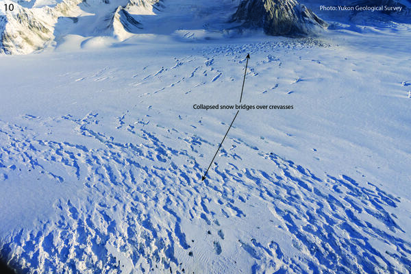
Collapsed snow bridges on crevasse field on the Hubbard Glacier between McArthur Peak and Mt. King George. Photo courtesy of Yukon Geological Survey.
Multimedia
Browse our photos and videos of landslide research and post-landslide investigations.
Images
12-12-25 Hubbard Glacier Collapsed Snow Bridges
Collapsed snow bridges on crevasse field on the Hubbard Glacier between McArthur Peak and Mt. King George. Photo courtesy of Yukon Geological Survey.
12-12-25 Mt. Vancouver and Mt. Logan Arete Landslides
12-12-25 Mt. Vancouver and Mt. Logan Arete LandslidesCollapsed snow bridges on crevasse field on the Hubbard Glacier between McArthur Peak and Mt. King George. Photo courtesy of Yukon Geological Survey.
12-12-25 Mt. Vancouver and Mt. Logan Arete Landslides
12-12-25 Mt. Vancouver and Mt. Logan Arete LandslidesCollapsed snow bridges on crevasse field on the Hubbard Glacier between McArthur Peak and Mt. King George. Photo courtesy of Yukon Geological Survey.
12-12-25 Mt. King George West Face Landslides
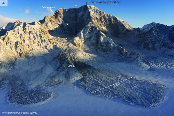
Large landslides on the southwest side of Mt. King George. The main debris lobe on the right is approximately 1000 m wide. The elevation difference between the peak and the glacier is approximately 1900 m. Photo courtesy of Yukon Geological Survey.
Large landslides on the southwest side of Mt. King George. The main debris lobe on the right is approximately 1000 m wide. The elevation difference between the peak and the glacier is approximately 1900 m. Photo courtesy of Yukon Geological Survey.
12-12-25 Mt. Vancouver Toppled Seracs
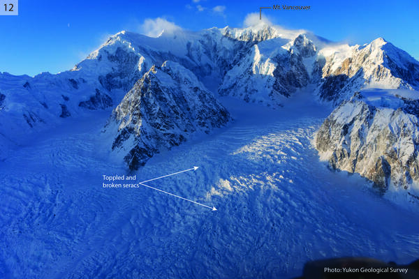
Seracs in an icefall on the east side of Mt. Vancouver (4812 m), toppled by shaking. Field of view is approximately 3.5 km wide. Photo courtesy of Yukon Geological Survey.
Seracs in an icefall on the east side of Mt. Vancouver (4812 m), toppled by shaking. Field of view is approximately 3.5 km wide. Photo courtesy of Yukon Geological Survey.
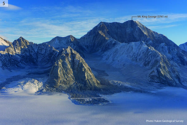
12-12-25 Mt. King George West Face Landslides
Landslides on the west side of Mt. King George. The central debris lobe is 500 m wide. Photo courtesy of Yukon Geological Survey.
Landslides on the west side of Mt. King George. The central debris lobe is 500 m wide. Photo courtesy of Yukon Geological Survey.
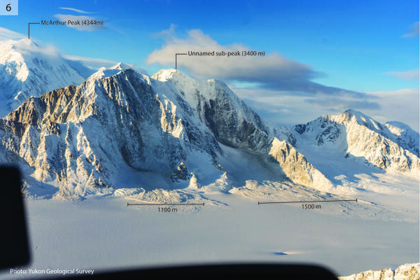
12-12-25 McArthur Peak East Face Landslides & Avalanches
12-12-25 McArthur Peak East Face Landslides & AvalanchesLandslides and avalanches on the east side of McArthur Peak. The left-hand debris lobe is 1100 m wide, and the right-hand debris lobe is 1500 m wide. The elevation difference between the peak and the glacier is approximately 1500 m. Photo courtesy of Yukon Geological Survey.
Videos

Landslide Detection, Monitoring, and Research Using OPERA Data
Landslide Detection, Monitoring, and Research Using OPERA DataThis presentation introduces NASA’s Observational Products for End-Users from Remote Sensing Analysis (OPERA) project and its suite of freely available satellite-derived products.

Postfire debris flow in the 2024 Elk Fire burn area
Postfire debris flow in the 2024 Elk Fire burn areaA debris flow recorded by a USGS Landslide Monitoring Station in the 2024 Elk Fire burn area near Dayton, Wyoming. The flow was triggered by intense rainfall during a thunderstorm on the evening of July 15, 2025.

Geologic Controls on Deep-Seated Landslides
The frequency and scale of landslides in a region are determined by both external forcing and inherent, site-specific susceptibility.
The frequency and scale of landslides in a region are determined by both external forcing and inherent, site-specific susceptibility.

Understanding large rock slides in deglaciated valleys in the Central and Patagonian Andes
Understanding large rock slides in deglaciated valleys in the Central and Patagonian AndesThe effects of deglaciation on the slope stability of glacial valleys have increasing importance in the context of climate change, with a role on the susceptibility to large-volume rock slides or rock avalanches and catastrophic cascading geohazards.

Controls on post-fire debris flows in Oregon
Wildfire often amplifies the likelihood and magnitude of debris flows in steep terrain. In arid climates (e.g. US Mountain West and Southwest), post-fire debris flows typically occur during the first rains following fire, suggesting that rainfall-driven erosion is a strong control on in-channel preconditioning and triggering of these hazards.
Wildfire often amplifies the likelihood and magnitude of debris flows in steep terrain. In arid climates (e.g. US Mountain West and Southwest), post-fire debris flows typically occur during the first rains following fire, suggesting that rainfall-driven erosion is a strong control on in-channel preconditioning and triggering of these hazards.

Atmospheric rivers cause the majority of precipitation-induced landslides in Western North America
Atmospheric rivers cause the majority of precipitation-induced landslides in Western North AmericaAtmospheric rivers (ARs) are transient channels of intense horizontal water vapor transport in the lower atmosphere.