



Southern California is well known to be susceptible to landslides, especially during periods of intense or prolonged rainfall, and these hazards can worsen during El Niño conditions.
This page summarizes the causes and impacts of historical and recent rainfall-triggered landslides and debris flows in southern California, including several major winter storms that caused damaging and deadly events during past El Niño climate patterns. It also links to maps, reports, and other resources that describe these hazards in greater detail.
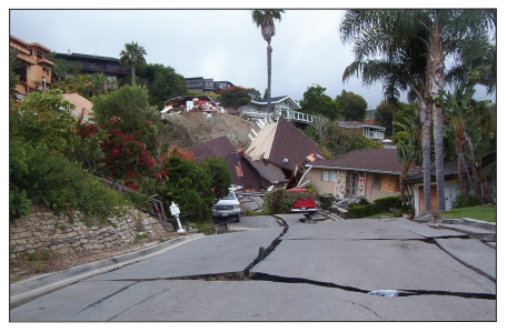
The U.S. Geological Survey has a long history of studying landslide hazards across southern California. USGS scientists have developed maps, reports, and assessments that describe where landslides may occur, why they happen, and which areas may be especially hazardous during intense or prolonged rainfall. Links to key reports and maps below can help to identify hazards associated with different types of landslides in this part of the state.
These resources provide examples of the types of landslides and impacts that could occur during future wet winters, including the upcoming 2026-2027 El Niño.
KEY RESOURCES
Southern California Landslide Fact Sheet
Overview of the types of landslides that occur in southern California and how to prepare for and stay safe from these hazards.
Preliminary soil-slip susceptibility maps, southwestern California
Maps showing where rainfall-triggered debris flows are most likely to occur in southern California.
Overview of the ARkStorm Scenario
A report that examines a scientifically realistic extreme winter storm scenario that could cause widespread flooding, landslides, property damage, and major social and economic impacts across California.
Shallow Landslides and Debris Flows
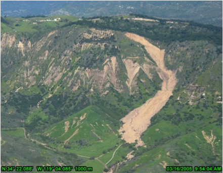
Shallow landsides are generally less than 10-15 feet (3-5 meters) in depth and can transform into fast-moving debris flows. USGS research has identified southwestern California as an area that is particularly susceptible to shallow landslides. The region also receives the right rainfall conditions necessary to trigger these shallow slides. Landslide susceptibility maps are based on previous landslide observations, slope steepness, and underlying geology.
Shallow landslides can occur at any time during the winter but are more likely when the ground is nearly saturated. In southern California, this typically requires at least 10 inches (25 centimeters) of cumulative winter rainfall. An intense burst of rainfall, 0.2 to 0.25 inches (5-6 millimeters) in an hour can trigger widespread shallow landslides.
Debris flows are fast-moving landslides that are particularly dangerous to life and property. These concrete-like mixtures of water, mud, boulders, trees, and other debris that can reach speeds greater than 35 mph, and travel miles beyond where they start.
Debris flows are typically triggered by intense rainfall or snowmelt in areas with steep slopes and available loose sediment. In areas burned by wildfire, they are triggered by runoff from rainfall traveling over the ground surface picking up sediment. Shallow landslides can also transform into debris flows.
During rainstorms, debris flows present a greater risk of death and injury to southern California residents than all other types of slope failure combined
KEY RESOURCES
Soil slips, debris flows, and rainstorms in the Santa Monica Mountains and vicinity, southern California
Report on rainfall-triggered landslides in and near the Santa Monica Mountains, southern California.
Deep-seated Landslides
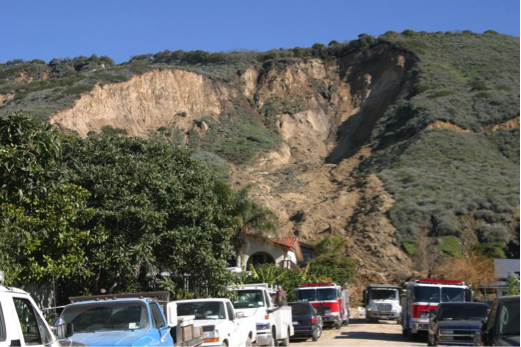
Deep-seated landslides large landslides that extend more than 10-15 feet (3-5 meters) deep. They can be triggered by when rainfall infiltrates deep beneath the ground, which can take weeks or months to occur. Some deep-seated landslides move slowly, while others can move quickly, with little warning.
The La Conchita landslide in Ventura County is an example of a deep-seated landslide that has experienced both styles of movement. In 1995, after an exceptionally wet winter, the landslide moved tens of meters and damaged nine homes. In 2005, following 15 days of near record-rainfall, a larger section of the slide failed suddenly, remobilizing part of the 1995 slide. The catastrophic movement of the 2005 landslide damaged or destroyed 36 houses and killed 10 people.
KEY RESOURCES
Landslide Hazards at La Conchita, California
Report describing the La Conchita area and its landslide history. The report also compares the 1995 and 2005 events that impacted the community.
Recent Burned Areas
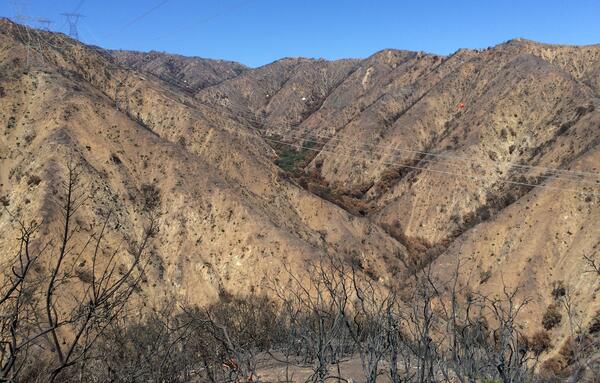
Since 2003, the USGS has assessed more than 700 recently burned area across the United States, including more than 200 in California. These emergency assessments produce maps showing debris-flow hazards in and near burned areas. The maps help identify where debris flows are most likely to occur, how large they could be, and where they might travel.
The USGS also determines the rainfall conditions likely to trigger debris flows and shares this information with the National Weather Service to support debris-flow early-warning efforts in areas affected by wildfire.
Debris-flow hazards can remain elevated several years after wildfire. AS burned areas recover, the threat of runoff-generated debris flows generally decreases. However, burned slopes may remain susceptible to shallow landslides, particularly during periods of heavy or prolonged rainfall.
KEY RESOURCES
Postfire Debris-flow Hazard Assessment Viewer
Dashboard for viewing and downloading the results of postfire debris-flow hazard assessments.
Postfire Debris Flow Fact Sheet
Overview of postfire debris-flow hazard and tips to prepare for and stay safe from these hazards.
Early Warning System for California
Report describing NOAA-USGS demonstration flash-flood and debris-flow early-warning system.
Postfire Debris-flow Hazard Page
USGS postfire debris-flow project homepage.
Coastal Cliff Erosion
Many areas of coastal California are subject to cliff erosion and coastal landslides. Hazards from these types of landslides can occur both at the bottom of cliffs (from burial) and at the tops of cliffs (from falling over). During the winter season in California, beaches typically erode thereby allowing waves to reach further inland and to inundate the bottoms of coastal cliffs. Wave energy is also typically higher during the winter, and particularly during El Niño events, thereby exacerbating the potential for coastal erosion. Coastal cliff failures may also occur simply as a result of heightened precipitation – wave action makes cliffs inherently unstable, and rainfall may be the ultimate trigger for failure, even during times with little to no wave action.
During and just after storms, existing coastal landslides may become reactivated and seemingly stable coastal cliffs may erode and fail rapidly. Background rates of coastal cliff erosion are variable along the California coast and tied to the rock or soil strength of the cliffs among other factors, but these measurements of historic coastal cliff retreat provide indications of places most susceptible to coastal landslides.

KEY RESOURCES
National Assessment of Shoreline Change Part 4: Historical Coastal Cliff Retreat along the California Coast
Report summarizing historical changes along California's coastal cliffs.
Landslide Monitoring in Southern California

Monitoring helps scientists understand how landslides behave and determine which storms may trigger them. Near real-time monitoring systems can be crucial in saving lives and protecting property.
For more than a decade, the USGS has operated near real-time landslide monitoring stations at several locations across the continental United States, including multiple sites in California. Two stations in southern California monitor changes in hillslope hydrologic conditions in the years following wildfire:
Below are other science projects associated with this project.

Early Warning System
Southern California is well known to be susceptible to landslides, especially during periods of intense or prolonged rainfall, and these hazards can worsen during El Niño conditions.
This page summarizes the causes and impacts of historical and recent rainfall-triggered landslides and debris flows in southern California, including several major winter storms that caused damaging and deadly events during past El Niño climate patterns. It also links to maps, reports, and other resources that describe these hazards in greater detail.
The U.S. Geological Survey has a long history of studying landslide hazards across southern California. USGS scientists have developed maps, reports, and assessments that describe where landslides may occur, why they happen, and which areas may be especially hazardous during intense or prolonged rainfall. Links to key reports and maps below can help to identify hazards associated with different types of landslides in this part of the state.
These resources provide examples of the types of landslides and impacts that could occur during future wet winters, including the upcoming 2026-2027 El Niño.
KEY RESOURCES
Southern California Landslide Fact Sheet
Overview of the types of landslides that occur in southern California and how to prepare for and stay safe from these hazards.
Preliminary soil-slip susceptibility maps, southwestern California
Maps showing where rainfall-triggered debris flows are most likely to occur in southern California.
Overview of the ARkStorm Scenario
A report that examines a scientifically realistic extreme winter storm scenario that could cause widespread flooding, landslides, property damage, and major social and economic impacts across California.
Shallow Landslides and Debris Flows
Shallow landsides are generally less than 10-15 feet (3-5 meters) in depth and can transform into fast-moving debris flows. USGS research has identified southwestern California as an area that is particularly susceptible to shallow landslides. The region also receives the right rainfall conditions necessary to trigger these shallow slides. Landslide susceptibility maps are based on previous landslide observations, slope steepness, and underlying geology.
Shallow landslides can occur at any time during the winter but are more likely when the ground is nearly saturated. In southern California, this typically requires at least 10 inches (25 centimeters) of cumulative winter rainfall. An intense burst of rainfall, 0.2 to 0.25 inches (5-6 millimeters) in an hour can trigger widespread shallow landslides.
Debris flows are fast-moving landslides that are particularly dangerous to life and property. These concrete-like mixtures of water, mud, boulders, trees, and other debris that can reach speeds greater than 35 mph, and travel miles beyond where they start.
Debris flows are typically triggered by intense rainfall or snowmelt in areas with steep slopes and available loose sediment. In areas burned by wildfire, they are triggered by runoff from rainfall traveling over the ground surface picking up sediment. Shallow landslides can also transform into debris flows.
During rainstorms, debris flows present a greater risk of death and injury to southern California residents than all other types of slope failure combined
KEY RESOURCES
Soil slips, debris flows, and rainstorms in the Santa Monica Mountains and vicinity, southern California
Report on rainfall-triggered landslides in and near the Santa Monica Mountains, southern California.
Deep-seated Landslides
Deep-seated landslides large landslides that extend more than 10-15 feet (3-5 meters) deep. They can be triggered by when rainfall infiltrates deep beneath the ground, which can take weeks or months to occur. Some deep-seated landslides move slowly, while others can move quickly, with little warning.
The La Conchita landslide in Ventura County is an example of a deep-seated landslide that has experienced both styles of movement. In 1995, after an exceptionally wet winter, the landslide moved tens of meters and damaged nine homes. In 2005, following 15 days of near record-rainfall, a larger section of the slide failed suddenly, remobilizing part of the 1995 slide. The catastrophic movement of the 2005 landslide damaged or destroyed 36 houses and killed 10 people.
KEY RESOURCES
Landslide Hazards at La Conchita, California
Report describing the La Conchita area and its landslide history. The report also compares the 1995 and 2005 events that impacted the community.
Recent Burned Areas
Since 2003, the USGS has assessed more than 700 recently burned area across the United States, including more than 200 in California. These emergency assessments produce maps showing debris-flow hazards in and near burned areas. The maps help identify where debris flows are most likely to occur, how large they could be, and where they might travel.
The USGS also determines the rainfall conditions likely to trigger debris flows and shares this information with the National Weather Service to support debris-flow early-warning efforts in areas affected by wildfire.
Debris-flow hazards can remain elevated several years after wildfire. AS burned areas recover, the threat of runoff-generated debris flows generally decreases. However, burned slopes may remain susceptible to shallow landslides, particularly during periods of heavy or prolonged rainfall.
KEY RESOURCES
Postfire Debris-flow Hazard Assessment Viewer
Dashboard for viewing and downloading the results of postfire debris-flow hazard assessments.
Postfire Debris Flow Fact Sheet
Overview of postfire debris-flow hazard and tips to prepare for and stay safe from these hazards.
Early Warning System for California
Report describing NOAA-USGS demonstration flash-flood and debris-flow early-warning system.
Postfire Debris-flow Hazard Page
USGS postfire debris-flow project homepage.
Coastal Cliff Erosion
Many areas of coastal California are subject to cliff erosion and coastal landslides. Hazards from these types of landslides can occur both at the bottom of cliffs (from burial) and at the tops of cliffs (from falling over). During the winter season in California, beaches typically erode thereby allowing waves to reach further inland and to inundate the bottoms of coastal cliffs. Wave energy is also typically higher during the winter, and particularly during El Niño events, thereby exacerbating the potential for coastal erosion. Coastal cliff failures may also occur simply as a result of heightened precipitation – wave action makes cliffs inherently unstable, and rainfall may be the ultimate trigger for failure, even during times with little to no wave action.
During and just after storms, existing coastal landslides may become reactivated and seemingly stable coastal cliffs may erode and fail rapidly. Background rates of coastal cliff erosion are variable along the California coast and tied to the rock or soil strength of the cliffs among other factors, but these measurements of historic coastal cliff retreat provide indications of places most susceptible to coastal landslides.
KEY RESOURCES
National Assessment of Shoreline Change Part 4: Historical Coastal Cliff Retreat along the California Coast
Report summarizing historical changes along California's coastal cliffs.
Landslide Monitoring in Southern California
Monitoring helps scientists understand how landslides behave and determine which storms may trigger them. Near real-time monitoring systems can be crucial in saving lives and protecting property.
For more than a decade, the USGS has operated near real-time landslide monitoring stations at several locations across the continental United States, including multiple sites in California. Two stations in southern California monitor changes in hillslope hydrologic conditions in the years following wildfire:
Below are other science projects associated with this project.