
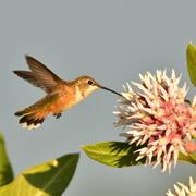
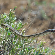
Sagebrush and Sage-Grouse
Report Offers Path Forward for Interagency Efforts to Revive the West’s Disappearing Sagebrush Ecosystem
USGS has been a leader in sagebrush ecosystem research and continues to meet the priority science needs of management agencies. Scientists bring a diversity of expertise and capabilities to address a wide variety of science needs at multiple spatial scales and are committed to providing high quality science to our management partners.
About the Sagebrush Working Group

The USGS Sagebrush Working Group, comprised of dozens of scientists across the agency, is committed to providing actionable science for management partners. On this webpage, you can learn more about the group’s comprehensive research portfolio and how its science supports public safety and economic decision-making across the West.
Related Publications

Browse through publications from the Land Management Research Program related to sagebrush and sage-grouse.

Synthesis of sage-grouse genetic information to support conservation and land management actions
KWIC Science: Rapid response products to meet resource managers’ priority science needs
Wildlife Ecology and Habitat Restoration Team
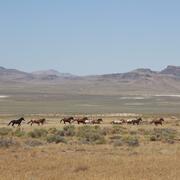
Science for management of America’s iconic wild horses and burros

Greater Sage-Grouse Population Monitoring Framework: Cheat Sheet

Greater Sage-Grouse Population Monitoring Framework: Targeted Annual Warning System Information Sheet

Data Harmonization for Greater Sage-Grouse Populations

Greater Sage-Grouse Population Monitoring Framework

A user-friendly decision support tool for monitoring and managing greater sage-grouse populations

A targeted annual warning system (TAWS) for identifying aberrant declines in greater sage-grouse populations

USGS Sagebrush Science: Supporting Public Safety and Economic Decision Making Across the West
