
Ecological Frontiers
Ecological Frontiers
Using new state-of-the-art integrated data and models, land-management scientists improve the quality and timeliness of current estimates of carbon sequestration, land change, fire, hydrology, and other ecosystem services to provide consistent, cross-disciplinary science products that can project the impact of resource management decisions that are of importance to land managers.
Filter Total Items: 55
KWIC Science: Rapid response products to meet resource managers’ priority science needs
Federal public land managers in the US are required by law to use science to inform management decisions. However, managers have limited time to identify science for use in decision making. Literature reviews are one tool to efficiently summarize science for use by managers, but are time-consuming to produce. Keyword in Context (KWIC) text analysis is a straightforward method of locating specific...
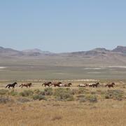
Science for management of America’s iconic wild horses and burros
Wild horses and burros are iconic wildlife of the western USA as well as a complicated management issue on tribal, state, and federal lands. Due to their history as domesticated animals, these wild equids – also called “free-roaming” or “feral” equids – can reproduce quickly, and have few natural predators, allowing their populations to grow rapidly if not managed. When populations are too large...
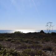
Where Land Meets Sea: USGS Science for Resilient Coastal Habitats
USGS coastal science plays a critical role in supporting the effective, science-based management of coastal ecosystems, where the biodiversity of land and sea meet. It provides managers with the information they need to make sound decisions. Through cutting-edge research, predictive modeling, and decision-support tools, USGS empowers resource managers to make informed, science-based choices. From...
By
Ecosystems Mission Area, Land Management Research Program, California Water Science Center, Eastern Ecological Science Center, Forest and Rangeland Ecosystem Science Center, Lower Mississippi-Gulf Water Science Center, Pacific Coastal and Marine Science Center, Western Ecological Research Center (WERC), Western Fisheries Research Center, Western Geographic Science Center, Wetland and Aquatic Research Center

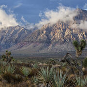
USGS Sagebrush Science: Supporting Public Safety and Economic Decision Making Across the West
The sagebrush biome is one of the largest ecosystems in North America. Encompassing nearly one-third of the continental U.S., it provides critical resources for millions of Americans and a home for hundreds of plants and animal species in the West. Natural resource management in sagebrush ecosystems can be complex, and science can support management decisions by providing knowledge and tools to...
By
Core Science Systems Mission Area, Ecosystems Mission Area, Biological Threats and Invasive Species Research Program, Climate Adaptation Science Centers, Cooperative Research Units, Land Management Research Program, Species Management Research Program, Earth Resources Observation and Science (EROS) Center, Forest and Rangeland Ecosystem Science Center, Fort Collins Science Center, Northern Rocky Mountain Science Center, Southwest Biological Science Center, Western Ecological Research Center (WERC), Wildland Fire Science
Recommendations for conducting landscape assessments to inform decision making on multiple-use public lands
Landscape assessments have been proposed as a mechanism for informing conservation and natural resource management actions at broad scales. We are documenting the process used in a large effort to conduct 14 such assessments across the western United States, and evaluating how the assessments were used in subsequent land use plans. In this project, we seek to identify methods and characteristics...
EESC Makes an Impact: Restoring the Chesapeake Bay Watershed
The Chesapeake Bay provides over $100 billion in annual economic value and is home to 18 million people. The USGS, including scientists from the Eastern Ecological Science Center (EESC), works with Federal, State, local, and academic partners to provide research and monitoring and to communicate results to inform management for the Chesapeake and other important landscapes across the Nation.

Ground-truthing an easy guide to biocrust morphogroups
Land and resource managers are increasingly aware of the contribution of biocrusts to ecological functions and have expressed interest in training and resources to recognize biocrusts in the field. This knowledge will help enable managers to address biocrusts in carrying out analyses under the National Environmental Policy Act (NEPA). WERC scientists have drafted a single page, easy guide to...

Fostering greater use of habitat models for managing rare and invasive plants on public lands
Habitat models can provide critical information on the current and potential distribution of plant species, as well as help target and support conservation efforts. Despite their potential utility in public land management, model use may be constrained by a variety of factors including staff access to and trust in models. In this project, we seek to bring together model users and model developers...

Alabama Barrier Island Restoration Assessment at Dauphin Island
Dauphin Island, Alabama, is the only barrier island providing protection to much of Alabama's coastal natural resources. Severely impacted by repeated extreme events, like Hurricane Katrina and Deepwater Horizon oil spill, USGS and partners are conducting a joint study to evaluate the feasibility of certain alternatives to increase resiliency and sustainability of the island.

Louisiana’s Coastwide Reference Monitoring System (CRMS)
The Coastwise Reference Monitoring System was designed to monitor the effectiveness of restoration actions at individual sites, as well as across the entire Louisiana coast.

Climate Change Effects on Coastal Marsh Foundation Species
Mangrove forests have migrated inland over the past few decades at many locations along the northern Gulf coast. This expansion has been attributed to factors associated with climate change, such as increased salinity resulting from sea-level rise and longer intervals between winter freezes, which can kill cold-intolerant mangrove species.

Influence of Sea-Level Rise on Wetland Vegetation Community Structure, Primary Productivity, Organic Matter Decomposition and Carbon Storage
This study will employ a space for time substitution to show long-term effects of rising sea-level and increasing salinity on vegetation community structure, primary production and decomposition. Productivity and decomposition rates will be estimated for four wetland plant community types defined by salinity zones and dominant plant species.