
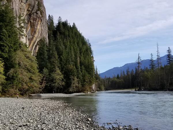
Orange streams are increasingly common in the Brooks Range of northern Alaska. The orange stream color reflects oxidized iron, but also often indicates elevated heavy metal concentrations. Our ongoing study aims to document these occurrences and the timing of their onset.
Images
Browse images from a wide range of science topics covered by USGS.
Filter Total Items: 988

An orange tributary joins the Kugururok River
Orange streams are increasingly common in the Brooks Range of northern Alaska. The orange stream color reflects oxidized iron, but also often indicates elevated heavy metal concentrations. Our ongoing study aims to document these occurrences and the timing of their onset.
Unuk River Streamgage
USGS Staff at the Unuk River Streamgage in Southeast Alaska. The Unuk River is the second smallest watershed in the transboundary study of Southeast Alaska, but has three large mining projects in development (Kerr-Sulplherets-Mitchell (KSM), Brucejack, and Eskay Creek)
USGS Staff at the Unuk River Streamgage in Southeast Alaska. The Unuk River is the second smallest watershed in the transboundary study of Southeast Alaska, but has three large mining projects in development (Kerr-Sulplherets-Mitchell (KSM), Brucejack, and Eskay Creek)
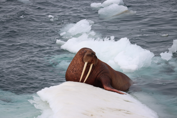
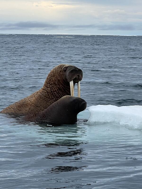
Adult female Pacific walrus sliding into the water
Adult female Pacific walrus sliding into the waterAn adult female Pacific walrus slides into the water as she assesses her surroundings. The female is 15 years or older based on the length of the tusks. USGS and the U.S.
Adult female Pacific walrus sliding into the water
Adult female Pacific walrus sliding into the waterAn adult female Pacific walrus slides into the water as she assesses her surroundings. The female is 15 years or older based on the length of the tusks. USGS and the U.S.
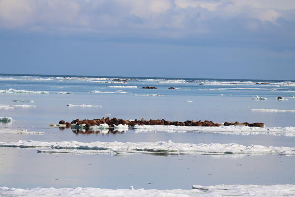
Walruses everywhere
Walrus groups hauled on sea ice as far as the eye can see in the Chukchi Sea. USGS and the U.S.
Walrus groups hauled on sea ice as far as the eye can see in the Chukchi Sea. USGS and the U.S.
A large and noisy walrus group amidst an aggregation of groups
A large and noisy walrus group amidst an aggregation of groupsAlarge, active, and noisy walrus group hauled on sea ice in the Chukchi Sea. USGS and the U.S.
A large and noisy walrus group amidst an aggregation of groups
A large and noisy walrus group amidst an aggregation of groupsAlarge, active, and noisy walrus group hauled on sea ice in the Chukchi Sea. USGS and the U.S.
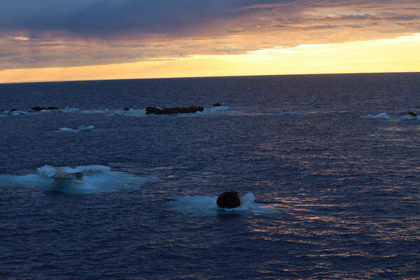
Arctic sunrise over resting walruses
A dim light shines during the summer Arctic morning in the Chukchi Sea as groups of Pacific walruses rest. USGS and the U.S.
A dim light shines during the summer Arctic morning in the Chukchi Sea as groups of Pacific walruses rest. USGS and the U.S.
Adult female walrus and one-year old young
An adult female walrus with a one-year old offspring. USGS and the U.S.
An adult female walrus with a one-year old offspring. USGS and the U.S.
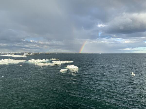
Arctic rainbow over sea ice in the Chukchi Sea
A rainbow emerges from an evening shower in the Chukchi Sea. USGS and the U.S.
A rainbow emerges from an evening shower in the Chukchi Sea. USGS and the U.S.

Orange water from a tributary of the Kugururok River
Orange water from a tributary of the Kugururok RiverOrange streams are increasingly common in the Brooks Range of northern Alaska. The orange stream color reflects oxidized iron, but also often indicates elevated heavy metal concentrations. Our ongoing study aims to document these occurrences and the timing of their onset.

Limited mixing of orange water and the Kugururok River
Limited mixing of orange water and the Kugururok RiverOrange streams are increasingly common in the Brooks Range of northern Alaska. The orange stream color reflects oxidized iron, but also often indicates elevated heavy metal concentrations. Our ongoing study aims to document these occurrences and the timing of their onset.

An orange tributary mixing into the pristine Kugururok River
An orange tributary mixing into the pristine Kugururok RiverOrange streams are increasingly common in the Brooks Range of northern Alaska. The orange stream color reflects oxidized iron, but also often indicates elevated heavy metal concentrations. Our ongoing study aims to document these occurrences and the timing of their onset.
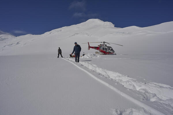
Snow core to measure accumulation on Kahiltna Glacier
Snow core to measure accumulation on Kahiltna GlacierThis is a 16 m (52.5-foot) core from Kahiltna Glacier at 3,055 m (10,023 feet), May 26, 2023. Kakiko Ramos-Leon (NPS, on the left) is standing where the core intersected the surface. Eric Ridington (pilot, in the middle) is pointing to the melt layers from summer 2022. The melt layers barely visible as grey stripes in the foreground are from summer 2021.
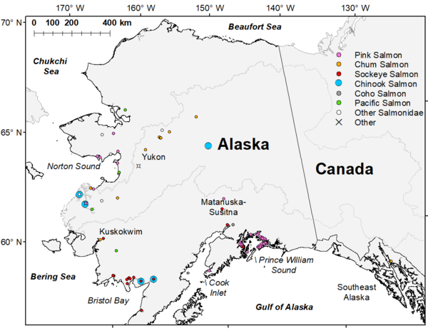
Map showing the premature mortality observations of Pacific salmon carcasses in Alaska
Map showing the premature mortality observations of Pacific salmon carcasses in AlaskaMap showing the premature mortality observations of Pacific salmon carcasses in Alaska during summer and fall of 2019. Symbol color and shape denote Pacific Salmon species or alternative taxonomic groupings specified in the legend.

Polar bear walking along Beaufort Sea coast
A polar bear walking along the Beaufort Sea coast with storm waves breaking behind it, filmed during fieldwork at Barter Island, Alaska.
A polar bear walking along the Beaufort Sea coast with storm waves breaking behind it, filmed during fieldwork at Barter Island, Alaska.

The Aleutian Cradle of Tsunamis
THE ALEUTIAN CRADLE OF TSUNAMIS
(Click here to read EOS Feature: Seismic Sources in the Aleutian Cradle of Tsunamis)

Two scientists wade in shallow wetland in Izembek National Wildlife Refuge, Alaska
Two scientists wade in shallow wetland in Izembek National Wildlife Refuge, AlaskaUSGS research hydrologist Laura Hubbard and Memorial University of Newfoundland's Jordan Wight wade with an orange inflatable boat in shallow wetland as they filter for infectious avian influenza in Izembek National Wildlife Refuge, Alaska.

Scientists walk between hundreds of spawning sockeye salmon in shallow lake at Izembek National Wildlife Refuge, Alaska
Scientists walk between hundreds of spawning sockeye salmon in shallow lake at Izembek National Wildlife Refuge, AlaskaUSGS Upper Midwest Water Science Center hydrologist Laura Hubbard (right, in yellow coat and PFD) and Jordan Wight (left, Memorial University of Newfoundland, Canada) walk between hundreds of spawning sockeye salmon in shallow lake at Izembek National Wildlife Refuge, Alaska as they filter water for avian influenza virus.

Filtering wetland water to sample for infectious avian influenza in Izembek National Wildlife Refuge, Alaska.
Filtering wetland water to sample for infectious avian influenza in Izembek National Wildlife Refuge, Alaska.Upper Midwest Water Science Center Hydrologist Laura Hubbard filters wetland water to sample for infectious avian influenza in Izembek National Wildlife Refuge, Alaska.

Scientists scout for brown bears before starting infectious avian influenza water sampling in Izembek National Wildlife Refuge, Alaska
Scientists scout for brown bears before starting infectious avian influenza water sampling in Izembek National Wildlife Refuge, AlaskaScientists scout for brown bears before starting infectious avian influenza water sampling in Izembek National Wildlife Refuge, Alaska.

Floodwater damage from Extratropical Typhoon Merbok in Nome, Alaska
Floodwater damage from Extratropical Typhoon Merbok in Nome, AlaskaA building lifted from its foundation by floodwater from Extratropical Typhoon Merbok is trapped under a bridge in Nome, Alaska.
Floodwater damage from Extratropical Typhoon Merbok in Nome, Alaska
Floodwater damage from Extratropical Typhoon Merbok in Nome, AlaskaA building lifted from its foundation by floodwater from Extratropical Typhoon Merbok is trapped under a bridge in Nome, Alaska.
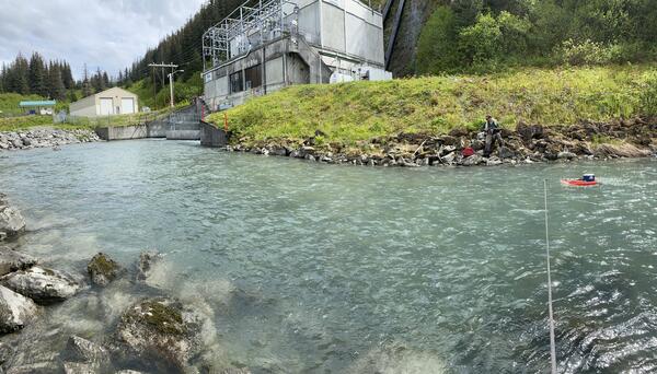
Solomon Gulch
USGS staff measuring discharge at the Solomon Gulch Hydropower tailrace, Valdez Alaska.
USGS staff measuring discharge at the Solomon Gulch Hydropower tailrace, Valdez Alaska.