
School Branch at Brownsburg IN - crawfish
Images
Images below come from a wide variety of USGS science activities in the Northeast Region. Science Center staff showcase what we do, who we are, and where we work conducting science that inform decision makers and addresses societal needs.
Filter Total Items: 2050

School Branch at Brownsburg IN - crawfish

School Branch at Brownsburg, IN - crawfish
School Branch at Brownsburg, IN - crawfish

Ohio River at Ironton, OH - gage in tower
Ohio River at Ironton, OH - gage in tower

Ohio River at Ironton, OH - equipment
Ohio River at Ironton, OH - equipment

R. Behrens on bridge protection pier, Rockaway Inlet station, NY
R. Behrens on bridge protection pier, Rockaway Inlet station, NYNortheast Region Photo Contest Winner | November 2018 | Where We Work
R. Behrens on bridge protection pier, Rockaway Inlet station, NY
R. Behrens on bridge protection pier, Rockaway Inlet station, NY
R. Behrens on bridge protection pier, Rockaway Inlet station, NYNortheast Region Photo Contest Winner | November 2018 | Where We Work
R. Behrens on bridge protection pier, Rockaway Inlet station, NY

Water Tower - Long Island
Water Tower - Long Island
Water Tower - Long Island

White River at Hazelton, IN - water quality gage install
White River at Hazelton, IN - water quality gage installWhite River at Hazelton, IN - water quality gage install
White River at Hazelton, IN - water quality gage install
White River at Hazelton, IN - water quality gage installWhite River at Hazelton, IN - water quality gage install

White River at Hazelton, IN - water quality gage install
White River at Hazelton, IN - water quality gage installWhite River at Hazelton, IN - water quality gage install
White River at Hazelton, IN - water quality gage install
White River at Hazelton, IN - water quality gage installWhite River at Hazelton, IN - water quality gage install

White River at Hazelton IN - closeup of rain gage equipment on bridge
White River at Hazelton IN - closeup of rain gage equipment on bridgeWhite River at Hazelton IN - closeup of rain gage equipment on bridge
White River at Hazelton IN - closeup of rain gage equipment on bridge
White River at Hazelton IN - closeup of rain gage equipment on bridgeWhite River at Hazelton IN - closeup of rain gage equipment on bridge

White River at Hazelton IN - raingage
White River at Hazelton IN - raingage

White River at Hazelton, IN - bridge view of rain gage equipment
White River at Hazelton, IN - bridge view of rain gage equipmentWhite River at Hazelton, IN - bridge view of rain gage location
White River at Hazelton, IN - bridge view of rain gage equipment
White River at Hazelton, IN - bridge view of rain gage equipmentWhite River at Hazelton, IN - bridge view of rain gage location

White River at Hazelton, IN - gage location
White River at Hazelton, IN - gage location

White River at Hazelton IN - Aubrey and Tim during gage installation
White River at Hazelton IN - Aubrey and Tim during gage installationWhite River at Hazelton IN - Aubrey and Tim during gage installation
White River at Hazelton IN - Aubrey and Tim during gage installation
White River at Hazelton IN - Aubrey and Tim during gage installationWhite River at Hazelton IN - Aubrey and Tim during gage installation

Core samples from Herricks Lane North test boring
Core samples from Herricks Lane North test boring showing contact between the upper glacial (Pleistocene) and Magothy (Cretaceous) aquifers
Core samples from Herricks Lane North test boring showing contact between the upper glacial (Pleistocene) and Magothy (Cretaceous) aquifers

305(b) groundwater quality sampling
305(b) groundwater quality sampling
305(b) groundwater quality sampling
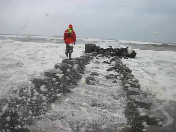
Measuring high water marks on a jetty into the Long Island Sound
Measuring high water marks on a jetty into the Long Island SoundUSGS scientist measuring high water marks on a jetty into the Long Island Sound during flooding in October of 2015.
Measuring high water marks on a jetty into the Long Island Sound
Measuring high water marks on a jetty into the Long Island SoundUSGS scientist measuring high water marks on a jetty into the Long Island Sound during flooding in October of 2015.

Flooding around Mill River streamflow gage 01171500 at Northampton, MA
Flooding around Mill River streamflow gage 01171500 at Northampton, MAFlooding around Mill River USGS streamflow gage 01171500 at Northampton, Massachusetts.
Flooding around Mill River streamflow gage 01171500 at Northampton, MA
Flooding around Mill River streamflow gage 01171500 at Northampton, MAFlooding around Mill River USGS streamflow gage 01171500 at Northampton, Massachusetts.

Ohio River at Ironton, OH - installing pipes
Ohio River at Ironton, OH - installing pipes to hol;d water quality equipment
Ohio River at Ironton, OH - installing pipes to hol;d water quality equipment

Ohio River at Ironton, OH - water quality equipment install
Ohio River at Ironton, OH - water quality equipment installOhio River at Ironton, OH - water quality equipment install
Ohio River at Ironton, OH - water quality equipment install
Ohio River at Ironton, OH - water quality equipment installOhio River at Ironton, OH - water quality equipment install

Ohio River at Ironton, OH - launching boat
Ohio River at Ironton, OH - launching boat

Ohio River at Ironton, OH - water quality equipment installation
Ohio River at Ironton, OH - water quality equipment installationOhio River at Ironton, OH - water quality equipment installation
Ohio River at Ironton, OH - water quality equipment installation
Ohio River at Ironton, OH - water quality equipment installationOhio River at Ironton, OH - water quality equipment installation