Sensor housing mid-bay-deployment screw-anchor Long Island, NY
Sensor housing mid-bay-deployment screw-anchor Long Island, NYSensor housing mid-bay-deployment screw-anchor

Official websites use .gov
A .gov website belongs to an official government organization in the United States.
Secure .gov websites use HTTPS
A lock () or https:// means you’ve safely connected to the .gov website. Share sensitive information only on official, secure websites.
Images below come from a wide variety of USGS science activities in the Northeast Region. Science Center staff showcase what we do, who we are, and where we work conducting science that inform decision makers and addresses societal needs.

Sensor housing mid-bay-deployment screw-anchor
Sensor housing mid-bay-deployment screw-anchor

Tidally restricted wetland in the Herring River Estuary, Cape Cod, MA
Tidally restricted wetland in the Herring River Estuary, Cape Cod, MA

Groundwater Sampling on Long Island

Collecting data on coastal wetland on Long Island, NY
Collecting data on coastal wetland on Long Island, NY

USGS Research Geologists Mark Carter and Wright Horton (right to left) and Virginia State Geologist David Spears staff an “Earthquakes in the Central Virginia Seismic Zone” information booth at the dedication ceremony for the newly constructed Louisa County, Virginia High School on 9 August 2015. The old high school building was damaged beyond repair during th
USGS Research Geologists Mark Carter and Wright Horton (right to left) and Virginia State Geologist David Spears staff an “Earthquakes in the Central Virginia Seismic Zone” information booth at the dedication ceremony for the newly constructed Louisa County, Virginia High School on 9 August 2015. The old high school building was damaged beyond repair during th

New York Riparian Wetlands
New York Riparian Wetlands

Mystic River at Medford, MA in the vicinity of the streamgage station 01103040.
Mystic River at Medford, MA in the vicinity of the streamgage station 01103040.

New York City Reservoirs - Ashokan Reservoir
New York City Reservoirs - Ashokan Reservoir
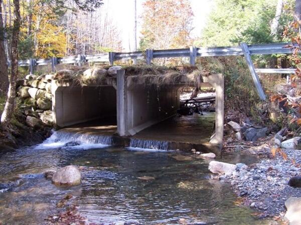
This photos shows the box culverts installed at Bronson Brook at Dingle Road in Worthington, Massachusetts. This undersized stream crossing has been renovated to increase habitat connectivity.
This photos shows the box culverts installed at Bronson Brook at Dingle Road in Worthington, Massachusetts. This undersized stream crossing has been renovated to increase habitat connectivity.
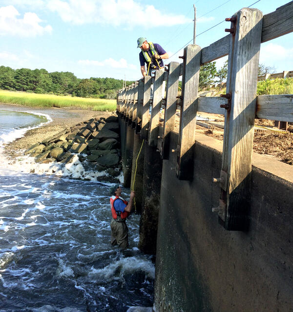
USGS staff installing monitoring equipment on the Chequessett Neck Road dike, Wellfleet, Massachusetts.
USGS staff installing monitoring equipment on the Chequessett Neck Road dike, Wellfleet, Massachusetts.

Huron River at Milan, OH - ADCP measurement

Steven Fuller Field Office Chief for the New Philadelphia, Ohio office
Steven Fuller Field Office Chief for the New Philadelphia, Ohio office

USGS scientists walk through a tern colony on the Monomoy National Wildlife Refuge (MA). Here, these scientists are using ecogeomorphological models to predict how this refuge will be impacted by sea-level rise and how that will ultimately effect shorebirds.
USGS scientists walk through a tern colony on the Monomoy National Wildlife Refuge (MA). Here, these scientists are using ecogeomorphological models to predict how this refuge will be impacted by sea-level rise and how that will ultimately effect shorebirds.

Photograph of monitoring station at U.S. Geological Survey streamgage 01115110, Huntinghouse Brook at Elmdale Road near North Scituate, Rhode Island.
Photograph of monitoring station at U.S. Geological Survey streamgage 01115110, Huntinghouse Brook at Elmdale Road near North Scituate, Rhode Island.

Photograph of the sampling system used to collect flow-proportional filtered and nonfiltered composite samples of stormflow at the 01115110, Huntinghouse Brook at Elmdale Road near North Scituate, Rhode Island, streamgage.
Photograph of the sampling system used to collect flow-proportional filtered and nonfiltered composite samples of stormflow at the 01115110, Huntinghouse Brook at Elmdale Road near North Scituate, Rhode Island, streamgage.

Indiana Harbor Canal at East Chicago, IN - gage house location
Indiana Harbor Canal at East Chicago, IN - gage house location

Indiana Harbor Canal at East Chicago, IN - gage house
Indiana Harbor Canal at East Chicago, IN - gage house

Indiana Harbor Canal at East Chicago, IN - gage house equipment
Indiana Harbor Canal at East Chicago, IN - gage house equipment

Piping plover chicks are well concealed in shallow nests on sandy beaches.
Piping plover chicks are well concealed in shallow nests on sandy beaches.

ADCP Stream measurement Connetquot Brook in Suffolk County, Long Island, NY
ADCP Stream measurement Connetquot Brook in Suffolk County, Long Island, NY

School Branch at Brownsburg, IN at bridge