
Sagebrush-dominated ecoregions in the western United States (sagebrush cover types shown in various shades of yellow, pink, and blue-grey).
Images
Images described and linked on this webpage come from a wide variety of USGS science activities and presentations performed by USGS Science Center staff members in the Region 7: Upper Colorado Basin. A search tool is provided to narrow the number of image files shown.
Filter Total Items: 548

Sagebrush-dominated ecoregions
Sagebrush-dominated ecoregions in the western United States (sagebrush cover types shown in various shades of yellow, pink, and blue-grey).

Four-wheel drive enthusiasts during Jeep Safari in Moab Utah
Four-wheel drive enthusiasts during Jeep Safari in Moab UtahFour-wheel drive enthusiasts during Jeep Safari in Moab Utah.
Four-wheel drive enthusiasts during Jeep Safari in Moab Utah
Four-wheel drive enthusiasts during Jeep Safari in Moab UtahFour-wheel drive enthusiasts during Jeep Safari in Moab Utah.

Boreal toad (Bufo boreas) mating ball
Boreal toad (Bufo boreas) mating ball, Bridger-Teton National Forest, Wyoming.
Boreal toad (Bufo boreas) mating ball, Bridger-Teton National Forest, Wyoming.

False-color-composite satellite image, Great Salt Lake, Sept 1999
False-color-composite satellite image, Great Salt Lake, Sept 1999This is a false-color-composite satellite image, Great Salt Lake, Sept 1999. Vegetation appears red.
False-color-composite satellite image, Great Salt Lake, Sept 1999
False-color-composite satellite image, Great Salt Lake, Sept 1999This is a false-color-composite satellite image, Great Salt Lake, Sept 1999. Vegetation appears red.

Cliff Palace, Mesa Verde National Park, Colorado - 1989
Cliff Palace, Mesa Verde National Park, Colorado - 1989The kivas, which were unexcavated by Nordenskiöld, are now exposed. Fewkes did considerable repair of the tower, kivas, and other structures when he excavated the ruin in 1909. Paths for visitors have been added to facilitate access. (Bill Howard).

False-colored-composite satellite image, Great Salt Lake, Sept 1987
False-colored-composite satellite image, Great Salt Lake, Sept 1987This is a false-colored-composite satellite image of the Great Salt Lake, taken in Sept, 1987. Vegetation appears red.
False-colored-composite satellite image, Great Salt Lake, Sept 1987
False-colored-composite satellite image, Great Salt Lake, Sept 1987This is a false-colored-composite satellite image of the Great Salt Lake, taken in Sept, 1987. Vegetation appears red.

False-colored-composite satellite image, Great Salt Lake, Sept 1972
False-colored-composite satellite image, Great Salt Lake, Sept 1972This is a false-colored-composite satellite image of Great Salt Lake, Sept 1972. The vegetation appears red.
False-colored-composite satellite image, Great Salt Lake, Sept 1972
False-colored-composite satellite image, Great Salt Lake, Sept 1972This is a false-colored-composite satellite image of Great Salt Lake, Sept 1972. The vegetation appears red.

Rockslide damage to the Golden Gate area near Mammoth Hot Springs
Rockslide damage to the Golden Gate area near Mammoth Hot SpringsRockslide damage to the Golden Gate area near Mammoth Hot Springs, Yellowstone National Park, as a result of the 1959 Hebgen Lake earthquake.
Rockslide damage to the Golden Gate area near Mammoth Hot Springs
Rockslide damage to the Golden Gate area near Mammoth Hot SpringsRockslide damage to the Golden Gate area near Mammoth Hot Springs, Yellowstone National Park, as a result of the 1959 Hebgen Lake earthquake.

Sapphire Pool, in the Upper Geyser Basin, erupting after the 1959 Hebg
Sapphire Pool, in the Upper Geyser Basin, erupting after the 1959 HebgSapphire Pool, in the Upper Geyser Basin, erupting after the 1959 Hebgen Lake earthquake.
Sapphire Pool, in the Upper Geyser Basin, erupting after the 1959 Hebg
Sapphire Pool, in the Upper Geyser Basin, erupting after the 1959 HebgSapphire Pool, in the Upper Geyser Basin, erupting after the 1959 Hebgen Lake earthquake.
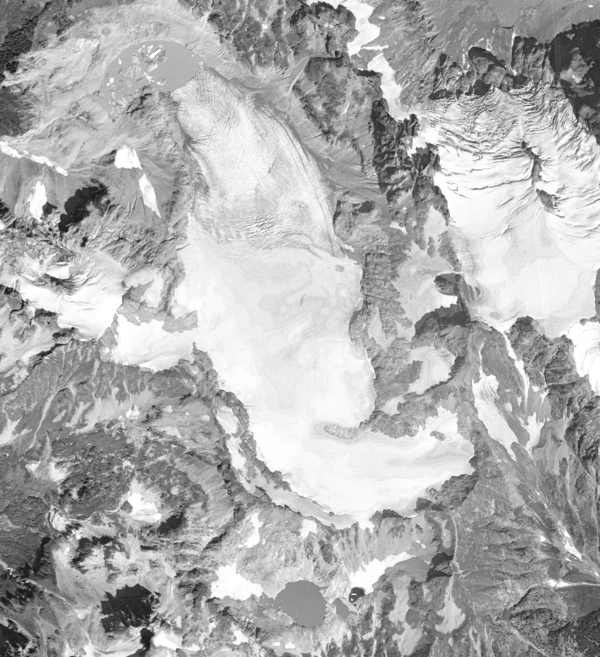
South Cascade Glacier August 13th, 1958
Aerial photograph of South Cascade Glacier, WA taken August 13th, 1958.
Aerial photograph of South Cascade Glacier, WA taken August 13th, 1958.

Cliff Palace, Mesa Verde National Park, Colorado
Cliff Palace, Mesa Verde National Park, Colorado - 1891
Cliff Palace, Mesa Verde National Park, Colorado - 1891

Old Faithful Geyser erupting, c.1878
Old Faithful Geyser in Upper Geyser Basin. 1878(?). Yellowstone National Park, Wyoming. U.S. Geological and Geographical Survey of the Territories (Hayden Survey).
Old Faithful Geyser in Upper Geyser Basin. 1878(?). Yellowstone National Park, Wyoming. U.S. Geological and Geographical Survey of the Territories (Hayden Survey).

Clarence King in camp, Salt Lake City, Utah
Clarence King in camp, Salt Lake City, Utah. United StatesGeological Exploration of the Fortieth Parallel (King Survey). 1868. Plate 96: Clarence King in camp, near Salt Lake City, Utah. October 1868.
(Photo by T.H. O'Sullivan.)
Clarence King in camp, Salt Lake City, Utah. United StatesGeological Exploration of the Fortieth Parallel (King Survey). 1868. Plate 96: Clarence King in camp, near Salt Lake City, Utah. October 1868.
(Photo by T.H. O'Sullivan.)

Elk in Northwestern Wyoming
Elk congregate on the Camp Creek Feed Ground in northwestern Wyoming.
Elk congregate on the Camp Creek Feed Ground in northwestern Wyoming.

Tree-Killing Las Conchas Fire in New Mexico
USGS scientist Craig D. Allen observes the results of the extensive, tree-killing fire that consumed almost all above-ground biomass in this part of the Las Conchas Fire burn area in the Jemez Mountains, New Mexico. Photo taken in late August 2011, two months post-fire.
USGS scientist Craig D. Allen observes the results of the extensive, tree-killing fire that consumed almost all above-ground biomass in this part of the Las Conchas Fire burn area in the Jemez Mountains, New Mexico. Photo taken in late August 2011, two months post-fire.

Maroon Lake, Colorado
Maroon Lake located in Colorado


USGS Researcher at Mesa Alta, New Mexico
USGS researcher Craig Allen stands on the edge of Mesa Alta, amid diverse forest and woodland in the uplands of northern New Mexico; note some recently dead ponderosa pine and Douglas-fir in the field of view. Forest drought stress is strongly correlated with tree mortality from poor growth, bark beetle outbreaks, and high-severity fire.
USGS researcher Craig Allen stands on the edge of Mesa Alta, amid diverse forest and woodland in the uplands of northern New Mexico; note some recently dead ponderosa pine and Douglas-fir in the field of view. Forest drought stress is strongly correlated with tree mortality from poor growth, bark beetle outbreaks, and high-severity fire.

Elk in Northwestern Wyoming
Elk congregate on the Camp Creek Feed Ground in northwestern Wyoming.
Elk congregate on the Camp Creek Feed Ground in northwestern Wyoming.

Prescribed Fire at Sunset in the Jemez Mountains, New Mexico
Prescribed Fire at Sunset in the Jemez Mountains, New MexicoSunset as seen through the smoke of a prescribed burn in the Jemez Mountains, New Mexico. The burn was conducted to restore fire as an ecosystem process and reduce hazardous tree densities and fuel loads due to more than 100 years of fire suppression. Foreground trees (Douglas-fir and aspen) were killed during the Cerro Grande fire in 2000.
