
Modeling and Prediction
Modeling and Prediction
Filter Total Items: 10
AI-driven science synthesis tools for resource managers
The scientific literature is abundant on drought-related topics in the western United States, including areas of the Colorado River Basin and the sagebrush biome. Scientists, resource managers, and decision makers use this science to assess, predict, and respond to the effects of drought on people and the environment. However, it can be difficult to quickly synthesize large amounts of research. To...

Impacts of changing climate and disturbance regimes on forest ecosystem resilience in the Southern Rocky Mountains
Climate-driven forest disturbances, particularly drought-induced tree mortality and large high-severity fires from increasingly warm and dry conditions, are altering forest ecosystems and the ecosystem services society depends on (e.g., water supplies) in the Southern Rockies and across the Western U.S. We will combine unique, long-term place-based ecological data, diverse methods (e.g., paleo...

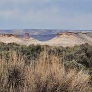
Drought Prediction Science
Drought is a prolonged and widespread deficit in available water supplies that creates multiple stressors across ecosystems and communities. The U.S. Geological Survey Water Mission Area conducts drought research and modeling to improve drought prediction capabilities. The research focus is on understanding the hydrological, ecological, and economic ramifications of drought. The modeling focus...

Drylands are highly vulnerable to climate and land use changes: what ecosystem changes are in store?
Improper land use during drought has been a major driver of land degradation in drylands globally, especially in the western U.S. Increasing aridity in western U.S. drylands under future climates will exacerbate risks associated with drought and land use decisions. This project provides critical observational, experimental, and modelling evidence to support our DOI partners with decision processes...

Major River Basin Assessments
In major river basins across the country, USGS scientists are working in collaboration with our partners to determine how to manage power generation, floods, and aquatic wildlife and habitats during periods of drought and low flow.
By

Predicting Climate Change Impact on Fish
Climate change is having a significant impact on fish, especially inland fish that rely on colder water for living and breeding. Common causes of drought, such as decreased precipitation and snowmelt runoff, combined with warmer temperatures are creating warmer water which is stressing many fish. Fish most at risk right now include sockeye salmon, lake trout, and walleye. Some fish, such as the...
By

Salinity and Seawater Intrusion
Changes to the freshwater-seawater interface in coastal communities can have adverse effects for humans and wildlife. For humans, seawater intrusion into public-supply wells can degrade groundwater quality limiting the amount of water that can be used from a well. For wildlife, changes in the salinity of coastal habitats can have adverse effects.
By

WaterSMART: Colorado River Basin
The Colorado River supplies water to more than 30 million people, irrigates nearly 4 million acres of cropland in the U.S. and Mexico, and supplies hydropower plants that generate more than 10 billion kilowatt-hours annually. Water from the river also provides for recreation and an array of environmental benefits, supporting a wide diversity of fish and wildlife and their habitats, and preserving...
By

California's Central Valley
Competition for water resources is growing throughout California, particularly in the Central Valley. Statewide population growth, anticipated reductions in Colorado River water deliveries, drought, and the ecological crisis in the Sacramento-San Joaquin Delta have created an intense demand for water. USGS Tools and information can be used to help manage the Central Valley aquifer system, an...
By

Simulation of Groundwater Flow in the Madison and Minnelusa Aquifers, Black Hills Area
The Madison and Minnelusa aquifers are critically important water resources that were a primary focus of the Black Hills Hydrology Study of the 1990s. These aquifers have a large influence on surface-water systems and provide the most important source of groundwater for municipal, domestic, agricultural, and industrial use in the area. Rapidly increasing demand from these aquifers may affect...