



These Elkhorn corals (Acropora palmata) near Buck Island, U.S. Virgin Islands have died and collapsed into rubble. As coral reef structure degrades, valuable habitat for marine life is lost and nearby coastlines become more susceptible to storms, waves and erosion.
Curt Storlazzi, PhD
My interests span the coastal zone, from coastal erosional processes to sediment dynamics in the shallow coastal ocean. My research focuses on the quantitative study of hydrodynamics, sediment transport, and geomorphology in coastal and marine environments.
Current Research Topics
- Coral reef morphology, hydrodynamics, and sediment, nutrient, contaminant, and larval transport
- The role of coral reefs and other coastal ecosystems in coastal hazard risk reduction
- The interplay between geologic structure, climatic fluctuations, and coastal processes
- High-resolution oceanographic instrumentation and coastal mapping techniques
The role of coral reefs in tropical coastal hazard risk reduction
The restoration of coastal habitats, particularly coral reefs, decreases the exposure of coastal communities to flooding hazards. We developed an integrated modeling system composed of oceanographic, coastal engineering, ecologic, geospatial, social, and economic tools and data to provide a rigorous valuation of where coral reef restoration could decrease the coastal flooding hazards faced in reef-fronted coastal communities. We follow risk-based valuation approaches to quantify the coastal flood risk reduction using information from the U.S. Census Bureau, U.S. Federal Emergency Management Agency, and U.S. Bureau of Economic Analysis. These data provide stakeholders and decision-makers with spatially explicit, rigorous valuation of how, where, when, and to whom coral reef restoration will increase critical coastal storm flood reduction benefits and has led to federal, state, and territorial actions to declare their coral reefs as natural infrastructure worthy of pre-disaster mitigation or post-disaster recovery funding. The overall goal is to ultimately reduce the risk to, and increase the resiliency of, the Nation’s tropical coastal communities while boosting their economies through tourism, fisheries, and recreational activities.
See: The Value of U.S. Coral Reefs for Risk Reduction (links below)
The influence of geophysical processes on coral reef ecosystems
Many tropical coastal environments have been impacted by development, nutrient and contaminant delivery, and natural and human-induced sedimentation. The high geomorphic and hydrodynamic complexity both within and between coral reefs, in conjunction with past technical restrictions, has limited our understanding of the nature of flow and the resulting flux of physical, chemical, and biologic material in these ecosystems. Understanding the physical controls on the timing and magnitude of flow and sediment, larvae, nutrient, and contaminant transport, along with their impact on seafloor geomorphology, stability, and sedimentation in these refugia are essential to assessing modern anthropogenic impacts on these ecosystems and help guide how to best protect and preserve these valuable ecosystems that provide billions of dollars per year to the Nation’s economy.
See: Coral Reef Project (links below)
Science and Products
Filter Total Items: 27

Nutrient Loading and Coral Health at Ofu, American Samoa
Declining water quality poses a significant and persistent threat to coral reefs worldwide, contributing to their widespread degradation. Identifying the specific impacts of water quality stressors is challenging due to the complex interplay of various physical and biological factors affecting reef health. Submarine groundwater discharge (SGD) plays a crucial role in transporting nutrients into...

Coral Reef Project
Explore the fascinating undersea world of coral reefs. Learn how we map, monitor, and model coral reefs so we can better understand, protect, and preserve our Nation's reefs.

Coastal Climate Impacts
The impacts of climate change and sea-level rise around the Pacific and Arctic Oceans can vary tremendously. Thus far the vast majority of national and international impact assessments and models of coastal climate change have focused on low-relief coastlines that are not near seismically active zones. Furthermore, the degree to which extreme waves and wind will add further stress to coastal...

Reef Hydrodynamics and Sediment Processes
As part of the USGS Coral Reef Project, the overall objective of this research effort is to better understand how circulation and sediment processes impact coral reefs and their adjacent coastlines.

Reef Resource Assessments - Planning for the Future
We are mapping and assessing all of the important geologic and oceanographic factors to identify those coral reefs most at risk and those reefs that are potentially the most resilient and the most likely to recover from natural and human-driven impacts.

Low-lying areas of tropical Pacific islands
Sea level is rising faster than projected in the western Pacific, so understanding how wave-driven coastal flooding will affect inhabited, low-lying islands—most notably, the familiar ring-shaped atolls—as well as the low-elevation areas of high islands in the Pacific Ocean, is critical for decision-makers in protecting infrastructure or relocating resources and people.

Role of Reefs in Coastal Protection
We are combining ocean, engineering, ecologic, social, and economic modeling to provide a high-resolution, rigorous, spatially-explicit valuation of the coastal flood protection benefits provided by coral reefs and the cost effectiveness of reef restoration for enhancing those benefits.

The Impact of Sea-Level Rise and Climate Change on Pacific Ocean Atolls
Providing basic understanding and specific information on storm-wave inundation of atoll islands that house Department of Defense installations, and assessing the resulting impact of sea-level rise and storm-wave inundation on infrastructure and freshwater availability under a variety of sea-level rise and climatic scenarios.

Coral Reef Project: Kwajalein Island
The USGS is working to provide a better understanding of how spatially-varying atoll morphology and coral cover interact with changes in water level to affect the propagation of waves of different heights and wavelengths across atoll reefs.

Coral Reef Project: Roi-Namur Island
The USGS is working to provide a better understanding of how spatially-varying atoll morphology and coral cover interact with changes in water level to affect the propagation of waves of different heights and wavelengths across atoll reefs.

Coral Reef Project: Maui
As part of USGS Coral Reef Project studies, the USGS has been heavily involved in efforts to improve the health and resilience of Maui's coral reef system, bringing expertise in mapping, circulation and sediment studies, and seismic surveys.

Coral Reef Project: Molokaʻi
As part of the USGS Coral Reef Project, recent USGS work on Molokaʻi includes looking into the coral record to find clues to past sedimentation events.
Filter Total Items: 29

Corals die, turn to rubble
These Elkhorn corals (Acropora palmata) near Buck Island, U.S. Virgin Islands have died and collapsed into rubble. As coral reef structure degrades, valuable habitat for marine life is lost and nearby coastlines become more susceptible to storms, waves and erosion.

Coral reefs, Kwajalein Atoll, Republic of the Marshall Islands
Coral reefs, Kwajalein Atoll, Republic of the Marshall IslandsUnderwater image of a wave breaking over a coral reef on Kwajalein Atoll in the Republic of the Marshall Islands. This image shows how the high hydrodynamic roughness of live, healthy corals causes friction that induces breaking of waves over coral reefs, reducing wave energy at the shoreline that can cause flooding and island overwash.

Restored coral reef off Kota Kinabalu, Borneo
A restored coral reef off Kota Kinabalu, Borneo, showing a mix of both concrete “Reef Balls” to rebuild reef topographic complexity and a variety of out-planted natural corals to increase coral coverage and species diversity.
A restored coral reef off Kota Kinabalu, Borneo, showing a mix of both concrete “Reef Balls” to rebuild reef topographic complexity and a variety of out-planted natural corals to increase coral coverage and species diversity.
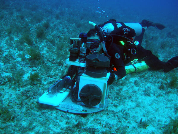
Installing oceanographic monitoring instrumentation on the seafloor
Installing oceanographic monitoring instrumentation on the seafloorUSGS research geologist Curt Storlazzi installs an instrument package on the seafloor of Maunalua Bay, Oʻahu. The platform, called a MiniPROBE, hosts six upward-looking acoustic Doppler current profilers (ADCP), seven conductivity and temperature (CT) sensors, and eight self-logging optical backscatter sensors (SLOBS).

Fish and coral in Tumon Bay Marine Reserve, Guam
Underwater photograph of Tumon Bay Marine Reserve, Guam, showing some of the amazing biologic diversity of coral reefs.
Underwater photograph of Tumon Bay Marine Reserve, Guam, showing some of the amazing biologic diversity of coral reefs.

Bleached coral in Tumon
Underwater photo of a stressed coral mound in Tumon Bay Marine Preserve in Guam.
Underwater photo of a stressed coral mound in Tumon Bay Marine Preserve in Guam.

Island-hopping Coral Larvae in Hawaii
Large-scale poster describing USGS work.

Coral Larvae
Underwater photograph of larvae being released into the water column from reef-building coral spawning off Maui the night of June 30, 2003. The white larvae are about 0.5 to 1.5 mm across.
Underwater photograph of larvae being released into the water column from reef-building coral spawning off Maui the night of June 30, 2003. The white larvae are about 0.5 to 1.5 mm across.
Science and Products
Filter Total Items: 27
Nutrient Loading and Coral Health at Ofu, American Samoa
Declining water quality poses a significant and persistent threat to coral reefs worldwide, contributing to their widespread degradation. Identifying the specific impacts of water quality stressors is challenging due to the complex interplay of various physical and biological factors affecting reef health. Submarine groundwater discharge (SGD) plays a crucial role in transporting nutrients into...
Coral Reef Project
Explore the fascinating undersea world of coral reefs. Learn how we map, monitor, and model coral reefs so we can better understand, protect, and preserve our Nation's reefs.
Coastal Climate Impacts
The impacts of climate change and sea-level rise around the Pacific and Arctic Oceans can vary tremendously. Thus far the vast majority of national and international impact assessments and models of coastal climate change have focused on low-relief coastlines that are not near seismically active zones. Furthermore, the degree to which extreme waves and wind will add further stress to coastal...
Reef Hydrodynamics and Sediment Processes
As part of the USGS Coral Reef Project, the overall objective of this research effort is to better understand how circulation and sediment processes impact coral reefs and their adjacent coastlines.
Reef Resource Assessments - Planning for the Future
We are mapping and assessing all of the important geologic and oceanographic factors to identify those coral reefs most at risk and those reefs that are potentially the most resilient and the most likely to recover from natural and human-driven impacts.
Low-lying areas of tropical Pacific islands
Sea level is rising faster than projected in the western Pacific, so understanding how wave-driven coastal flooding will affect inhabited, low-lying islands—most notably, the familiar ring-shaped atolls—as well as the low-elevation areas of high islands in the Pacific Ocean, is critical for decision-makers in protecting infrastructure or relocating resources and people.
Role of Reefs in Coastal Protection
We are combining ocean, engineering, ecologic, social, and economic modeling to provide a high-resolution, rigorous, spatially-explicit valuation of the coastal flood protection benefits provided by coral reefs and the cost effectiveness of reef restoration for enhancing those benefits.
The Impact of Sea-Level Rise and Climate Change on Pacific Ocean Atolls
Providing basic understanding and specific information on storm-wave inundation of atoll islands that house Department of Defense installations, and assessing the resulting impact of sea-level rise and storm-wave inundation on infrastructure and freshwater availability under a variety of sea-level rise and climatic scenarios.
Coral Reef Project: Kwajalein Island
The USGS is working to provide a better understanding of how spatially-varying atoll morphology and coral cover interact with changes in water level to affect the propagation of waves of different heights and wavelengths across atoll reefs.
Coral Reef Project: Roi-Namur Island
The USGS is working to provide a better understanding of how spatially-varying atoll morphology and coral cover interact with changes in water level to affect the propagation of waves of different heights and wavelengths across atoll reefs.
Coral Reef Project: Maui
As part of USGS Coral Reef Project studies, the USGS has been heavily involved in efforts to improve the health and resilience of Maui's coral reef system, bringing expertise in mapping, circulation and sediment studies, and seismic surveys.
Coral Reef Project: Molokaʻi
As part of the USGS Coral Reef Project, recent USGS work on Molokaʻi includes looking into the coral record to find clues to past sedimentation events.
Filter Total Items: 29
Corals die, turn to rubble
These Elkhorn corals (Acropora palmata) near Buck Island, U.S. Virgin Islands have died and collapsed into rubble. As coral reef structure degrades, valuable habitat for marine life is lost and nearby coastlines become more susceptible to storms, waves and erosion.
These Elkhorn corals (Acropora palmata) near Buck Island, U.S. Virgin Islands have died and collapsed into rubble. As coral reef structure degrades, valuable habitat for marine life is lost and nearby coastlines become more susceptible to storms, waves and erosion.
Coral reefs, Kwajalein Atoll, Republic of the Marshall Islands
Coral reefs, Kwajalein Atoll, Republic of the Marshall IslandsUnderwater image of a wave breaking over a coral reef on Kwajalein Atoll in the Republic of the Marshall Islands. This image shows how the high hydrodynamic roughness of live, healthy corals causes friction that induces breaking of waves over coral reefs, reducing wave energy at the shoreline that can cause flooding and island overwash.
Restored coral reef off Kota Kinabalu, Borneo
A restored coral reef off Kota Kinabalu, Borneo, showing a mix of both concrete “Reef Balls” to rebuild reef topographic complexity and a variety of out-planted natural corals to increase coral coverage and species diversity.
A restored coral reef off Kota Kinabalu, Borneo, showing a mix of both concrete “Reef Balls” to rebuild reef topographic complexity and a variety of out-planted natural corals to increase coral coverage and species diversity.
Installing oceanographic monitoring instrumentation on the seafloor
Installing oceanographic monitoring instrumentation on the seafloorUSGS research geologist Curt Storlazzi installs an instrument package on the seafloor of Maunalua Bay, Oʻahu. The platform, called a MiniPROBE, hosts six upward-looking acoustic Doppler current profilers (ADCP), seven conductivity and temperature (CT) sensors, and eight self-logging optical backscatter sensors (SLOBS).
Fish and coral in Tumon Bay Marine Reserve, Guam
Underwater photograph of Tumon Bay Marine Reserve, Guam, showing some of the amazing biologic diversity of coral reefs.
Underwater photograph of Tumon Bay Marine Reserve, Guam, showing some of the amazing biologic diversity of coral reefs.
Bleached coral in Tumon
Underwater photo of a stressed coral mound in Tumon Bay Marine Preserve in Guam.
Underwater photo of a stressed coral mound in Tumon Bay Marine Preserve in Guam.
Island-hopping Coral Larvae in Hawaii
Large-scale poster describing USGS work.
Coral Larvae
Underwater photograph of larvae being released into the water column from reef-building coral spawning off Maui the night of June 30, 2003. The white larvae are about 0.5 to 1.5 mm across.
Underwater photograph of larvae being released into the water column from reef-building coral spawning off Maui the night of June 30, 2003. The white larvae are about 0.5 to 1.5 mm across.