An official website of the United States government
Here's how you know
Official websites use .gov
A .gov website belongs to an official government organization in the United States.
Secure .gov websites use HTTPS
A lock () or https:// means you’ve safely connected to the .gov website. Share sensitive information only on official, secure websites.
We are mapping and assessing all of the important geologic and oceanographic factors to identify those coral reefs most at risk and those reefs that are potentially the most resilient and the most likely to recover from natural and human-driven impacts.
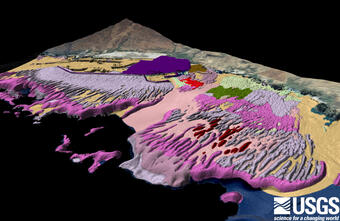
Oblique onshore view of sea floor characterization map off Puʻukoholā Heiau National Historic Site and Kawaihae Harbor, Hawaiʻi.
Coral reefs are facing increasing stress from global climate change combined with local stresses from over-fishing, sedimentation, and other sources of land-based pollution. Considering the potential for these stressors to increase the rate of coral reef degradation to dire levels, coral reef scientists and managers world-wide are shifting emphasis from prevention towards identifying the key mechanisms controlling reef resiliency and determining where coral reefs will be the most viable in the future. Thus far, the scientific community has mostly focused on the biologic indicators of resiliency, such as coral cover, species diversity, and fish populations. The parameters that influence the health and sustainability of coral reefs are diverse and include changes in watersheds, coastal development, stream discharge, coastal circulation, wave stresses, and larval pathways. They also include potential natural processes that can potentially reduce stress (such as upwelling; internal wave mixing; submarine groundwater discharge). Identifying coral reef areas that have the highest potential for survival requires a cross-cutting assessment of all of the salient geographic, geologic, ecologic, and oceanographic factors. Less than half of the US National Parks and US Wildlife Refuges that contain coral reef resources have high-resolution assessments of their coral reefs. How does an agency manage today or predict what will happen under climate change when they don't know what resources they have or their current status? Furthermore, scientists and resource managers have noted that less than 1% of the U.S.’s coral reefs are fully protected, and that to preserve US coral reefs, a network of marine refuges must be established.
USGS researchers prepare vertical-drop and oblique-towed video camera systems on F/V (fishing vessel) Alyce C to collect digital imagery for ground-truthing habitat maps derived from remotely-sensed data.
This comprises two distinct but interrelated efforts. First, we are conducting site-specific, high-resolution, benthic habitat mapping to support management of Department of the Interior areas (National Park Service park units, U.S. Fish & Wildlife Service refuges). The second effort is building on our expertise in benthic habitat mapping, watershed analysis, coastal circulation, sediment dynamics, submarine groundwater discharge, and numerical modeling to develop a comprehensive evaluation of US coral reefs. We are assessing all of the important geologic and oceanographic factors to identify those reefs most at risk and those reefs that are potentially the most resilient and the most likely to recover from an extreme event. The data produced through these efforts are being incorporated into multi-layered, interactive GIS databases for use by the scientific and management community overseeing US coral reefs.
Caption for large photo, top of page: Geo-referenced underwater image of Porites species corals imaged by a digital-towed camera system during a ground-truthing cruise in Kaloko-Honokōhau National Historical Park, Hawaiʻi.
The specific objectives of this project are to identify and describe the processes that are important in determining rates of coral-reef construction. How quickly the skeletons of calcifying organisms accumulate to form massive barrier-reef structure is determined by processes of both construction (how fast organisms grow and reproduce) and destruction (how fast reefs break down by mechanical...
The specific objectives of this project are to identify and describe the processes that are important in determining rates of coral-reef construction. How quickly the skeletons of calcifying organisms accumulate to form massive barrier-reef structure is determined by processes of both construction (how fast organisms grow and reproduce) and destruction (how fast reefs break down by mechanical...
It is critical to start measuring calcification rates in a systematic way now, particularly at subtropical latitudes where conditions fluctuate seasonally, so that we can understand how dynamic ocean conditions affect calcifying organisms today and predict possible changes in the future. We established a calcification monitoring network in the Florida Keys and have been measuring calcification...
It is critical to start measuring calcification rates in a systematic way now, particularly at subtropical latitudes where conditions fluctuate seasonally, so that we can understand how dynamic ocean conditions affect calcifying organisms today and predict possible changes in the future. We established a calcification monitoring network in the Florida Keys and have been measuring calcification...
An extensive set of physics-based XBeach Non-hydrostatic hydrodynamic model simulations (with input files here included) were used to evaluate the influence of shore-normal reef channels on flooding along fringing reef-lined coasts, specifically during extreme wave conditions when the risk for coastal flooding and the resulting impact to coastal communities is greatest. These input files...
This dataset consists of physics-based XBeach Non-hydrostatic hydrodynamic models input files used to study how coral reef restoration affects waves and wave-driven water levels over coral reefs, and the resulting wave-driven runup on the adjacent shoreline. Coral reefs are effective natural coastal flood barriers that protect adjacent communities. Coral degradation compromises the...
Coral reefs provide important protection for tropical coastlines against the impact of large waves and storm damage by energy dissipation through wave breaking and bottom friction. However, climate change and sea level rise have led to growing concern for how the hydrodynamics across these reefs will evolve and whether these changes will leave tropical coastlines more vulnerable to large...
This data set consists of physics-based Delft3D-FLOW and SWAN hydrodynamic models input files used to study the wave-induced 3D flow over spur-and-groove (SAG) formations. SAG are a common and impressive characteristic of coral reefs. They are composed of a series of submerged shore-normal coral ridges (spurs) separated by shore-normal patches of sediment (grooves) on the fore reef of...
Using global climate model projections of sea-surface temperature at coral reef sites, we modeled the effects of depth and exposure to semidiurnal temperature fluctuations to examine how these effects may alter the projected year of annual severe bleaching for coral reef sites globally. Here we present the first global maps of the effects these processes have on bleaching projections for...
This data release includes representative cluster profiles (RCPs) from a large (>24,000) selection of coral reef topobathymetric cross-shore profiles (Scott and others, 2020). We used statistics, machine learning, and numerical modelling to develop the set of RCPs, which can be used to accurately represent the shoreline hydrodynamics of a large variety of coral reef-lined coasts around...
This data release includes the XBeach input data files used to evaluate the importance of explicitly modeling sea-swell waves for runup. This was examined using a 2D XBeach short wave-averaged (surfbeat, XB-SB) and a wave-resolving (non-hydrostatic, XB-NH) model of Roi-Namur Island on Kwajalein Atoll in the Republic of Marshall Islands. Results show that explicitly modelling the sea...
This data release provides flooding extent polygons (flood masks) and depth values (flood points) based on wave-driven total water levels for 22 locations within the States of Hawaii and Florida, the Territories of Guam, American Samoa, Puerto Rico, and the U.S. Virgin Islands, and the Commonwealth of the Northern Mariana Islands. For each of the 22 locations there are eight associated...
We developed the HyCReWW metamodel to predict wave run-up under a wide range of coral reef morphometric and offshore forcing characteristics. Due to the complexity and high dimensionality of the problem, we assumed an idealized one-dimensional reef profile, characterized by seven primary parameters. XBeach Non-Hydrostatic was chosen to create the synthetic dataset and Radial Basis...
Curt Storlazzi - Coral Reefs as National, Natural Infrastructure
Coral reefs act like submerged breakwaters by breaking waves and dissipating their energy offshore before they flood coastal properties and communities. This is an enormously valuable function: In 2017, Hurricanes Harvey, Irma and Maria alone caused over \$265 billion in damage across the nation.
Coral reefs act like submerged breakwaters by breaking waves and dissipating their energy offshore before they flood coastal properties and communities. This is an enormously valuable function: In 2017, Hurricanes Harvey, Irma and Maria alone caused over \$265 billion in damage across the nation.
Many populated, tropical coastlines fronted by fringing coral reefs are exposed to wave-driven marine flooding that is exacerbated by sea-level rise. Most fringing coral reef are not alongshore uniform, but bisected by shore-normal channels; however, little is known about the influence of such channels on alongshore variations on runup and flooding of the adjacent coastline. We con...
This report was prepared by the U.S. Environmental Protection Agency (USEPA), Office of Research and Development, as part of the Air, Climate and Energy (ACE) research program, with support from Tetra Tech, Inc., and in collaboration with the National Oceanic and Atmospheric Administration, the U.S. Geological Survey, and The Nature Conservancy. The ACE research program provides...
Authors
Catherine A. Courtney, Jordon M. West, Curt D. Storlazzi, T. Shay Viehman, Richard Czaplinski, Erin Hague, Elizabeth C. Shaver
Pila‘a reef on the north shore of Kaua‘i, Hawai‘i was subjected to a major flood event in 2001 that deposited extensive sediment on the reef flat, resulting in high coral mortality. To document potential recovery, this study replicated benthic and sediment surveys conducted immediately following the event and 15 years later. Coral cores were analyzed to determine coral growth rates and...
Authors
Ku'ulei S. Rodgers, A. Richards Dona, Y. O. Stender, A. O. Tsang, J. H. J. Han, Rebecca Weible, Nancy G. Prouty, Curt D. Storlazzi, Andrew M. Graham
The increasing pressure on Earth's ecosystems due to climate change is becoming more and more evident and the impacts of climate change are especially visible on coral reefs. Understanding how climate change interacts with the physical environment of reefs to impact coral growth and reef development is critically important to predicting the persistence of reefs into the future. In this...
Authors
Gijs Hendrickx, Peter M. J. Herman, Jasper T. Dijkstra, Curt D. Storlazzi, Lauren T. Toth
Increasing the resilience of coastal communities while decreasing the risk to them are key to the continued inhabitance and sustainability of these areas. Low-lying coral reef-lined islands are experiencing storm wave-driven flood events that currently strike with little to no warning. These events are occurring more frequently and with increasing severity. There is a need along the...
Authors
William Skirving, Curt D. Storlazzi, Emily A Smail
Coral reefs are widely recognised for providing a natural breakwater effect that modulates erosion and flooding hazards on low‐lying sedimentary reef islands. Increased water depth across reef platforms due sea‐level rise (SLR) can compromise this breakwater effect and enhance island exposure to these hazards, but reef accretion in response to SLR may positively contribute to island...
Authors
Gerd Masselink, Robert T. McCall, Eddie Beetham, Paul Kench, Curt D. Storlazzi
Coral reefs worldwide are experiencing rapid degradation in response to climate and land-use change, namely effects of warming sea-surface temperatures, contaminant runoff, and overfishing. Extensive coral bleaching caused by the steady rise of sea-surface temperatures is projected to increase, but our understanding and ability to predict where corals may be most resilient to this effect...
Authors
Eric E. Grossman, Lisa Marrack, Nathan R. vanArendonk
Coral reefs are an important source of sediment for reef-lined coasts by helping to maintain beaches while also providing protection in the form of wave energy dissipation. Understanding the mechanisms by which sediment is delivered to the coast as well as better constraining the total volumes generated are critical for projecting future coastal change. A month-long hydrodynamics and...
Authors
Kurt J. Rosenberger, Curt D. Storlazzi, Olivia M. Cheriton, Andrew Pomeroy, Jeff E. Hansen, Ryan Lowe, Mark Buckley
Observations show ocean temperatures are rising due to climate change, resulting in a fivefold increase in the incidence of regional-scale coral bleaching events since the 1980s; analyses based on global climate models forecast bleaching will become an annual event for most of the world’s coral reefs within 30–50 yr. Internal waves at tidal frequencies can regularly flush reefs with...
Authors
Curt D. Storlazzi, Olivia M. Cheriton, Ruben Van Hooidonk, Zhongxiang Zhao, Russell E. Brainard
Coral reefs are widely recognized as critical to Hawaiʻi’s economy, food resources, and protection from damaging storm waves. Yet overfishing, land-based pollution, and climate change are threatening the health and sustainability of those reefs, and accordingly, both the Federal and State governments have called for protection and effective management. In 2000, the U.S. Coral Reef Task...
Authors
Michael E. Field, Curt D. Storlazzi, Ann E. Gibbs, Nicole L. D'Antonio, Susan A. Cochran
Connectivity among individual marine protected areas (MPAs) is one of the most important considerations in the design of integrated MPA networks. To provide such information for managers in Hawaii, USA, a numerical circulation model was developed to determine the role of ocean currents in transporting coral larvae from natal reefs throughout the high volcanic islands of the Maui Nui...
Authors
Curt D. Storlazzi, Maarten van Ormondt, Yi-Leng Chen, Edwin P. L. Elias
The coastal and upslope terrains of West Maui have had a long history of impacts owing to more than a century of human activities. Resource extraction, agriculture, as well as residential and resort development have caused land-based pollution that impairs water quality and adversely impact the adjacent marine ecosystem. Today, West Maui’s coral reefs are chronically impacted by the...
Authors
Bernardo Vargas-Angel, Darla White, Curt D. Storlazzi, Tova Callender, Paulo Maurin
We are mapping and assessing all of the important geologic and oceanographic factors to identify those coral reefs most at risk and those reefs that are potentially the most resilient and the most likely to recover from natural and human-driven impacts.
Oblique onshore view of sea floor characterization map off Puʻukoholā Heiau National Historic Site and Kawaihae Harbor, Hawaiʻi.
Coral reefs are facing increasing stress from global climate change combined with local stresses from over-fishing, sedimentation, and other sources of land-based pollution. Considering the potential for these stressors to increase the rate of coral reef degradation to dire levels, coral reef scientists and managers world-wide are shifting emphasis from prevention towards identifying the key mechanisms controlling reef resiliency and determining where coral reefs will be the most viable in the future. Thus far, the scientific community has mostly focused on the biologic indicators of resiliency, such as coral cover, species diversity, and fish populations. The parameters that influence the health and sustainability of coral reefs are diverse and include changes in watersheds, coastal development, stream discharge, coastal circulation, wave stresses, and larval pathways. They also include potential natural processes that can potentially reduce stress (such as upwelling; internal wave mixing; submarine groundwater discharge). Identifying coral reef areas that have the highest potential for survival requires a cross-cutting assessment of all of the salient geographic, geologic, ecologic, and oceanographic factors. Less than half of the US National Parks and US Wildlife Refuges that contain coral reef resources have high-resolution assessments of their coral reefs. How does an agency manage today or predict what will happen under climate change when they don't know what resources they have or their current status? Furthermore, scientists and resource managers have noted that less than 1% of the U.S.’s coral reefs are fully protected, and that to preserve US coral reefs, a network of marine refuges must be established.
USGS researchers prepare vertical-drop and oblique-towed video camera systems on F/V (fishing vessel) Alyce C to collect digital imagery for ground-truthing habitat maps derived from remotely-sensed data.
This comprises two distinct but interrelated efforts. First, we are conducting site-specific, high-resolution, benthic habitat mapping to support management of Department of the Interior areas (National Park Service park units, U.S. Fish & Wildlife Service refuges). The second effort is building on our expertise in benthic habitat mapping, watershed analysis, coastal circulation, sediment dynamics, submarine groundwater discharge, and numerical modeling to develop a comprehensive evaluation of US coral reefs. We are assessing all of the important geologic and oceanographic factors to identify those reefs most at risk and those reefs that are potentially the most resilient and the most likely to recover from an extreme event. The data produced through these efforts are being incorporated into multi-layered, interactive GIS databases for use by the scientific and management community overseeing US coral reefs.
Caption for large photo, top of page: Geo-referenced underwater image of Porites species corals imaged by a digital-towed camera system during a ground-truthing cruise in Kaloko-Honokōhau National Historical Park, Hawaiʻi.
The specific objectives of this project are to identify and describe the processes that are important in determining rates of coral-reef construction. How quickly the skeletons of calcifying organisms accumulate to form massive barrier-reef structure is determined by processes of both construction (how fast organisms grow and reproduce) and destruction (how fast reefs break down by mechanical...
The specific objectives of this project are to identify and describe the processes that are important in determining rates of coral-reef construction. How quickly the skeletons of calcifying organisms accumulate to form massive barrier-reef structure is determined by processes of both construction (how fast organisms grow and reproduce) and destruction (how fast reefs break down by mechanical...
It is critical to start measuring calcification rates in a systematic way now, particularly at subtropical latitudes where conditions fluctuate seasonally, so that we can understand how dynamic ocean conditions affect calcifying organisms today and predict possible changes in the future. We established a calcification monitoring network in the Florida Keys and have been measuring calcification...
It is critical to start measuring calcification rates in a systematic way now, particularly at subtropical latitudes where conditions fluctuate seasonally, so that we can understand how dynamic ocean conditions affect calcifying organisms today and predict possible changes in the future. We established a calcification monitoring network in the Florida Keys and have been measuring calcification...
An extensive set of physics-based XBeach Non-hydrostatic hydrodynamic model simulations (with input files here included) were used to evaluate the influence of shore-normal reef channels on flooding along fringing reef-lined coasts, specifically during extreme wave conditions when the risk for coastal flooding and the resulting impact to coastal communities is greatest. These input files...
This dataset consists of physics-based XBeach Non-hydrostatic hydrodynamic models input files used to study how coral reef restoration affects waves and wave-driven water levels over coral reefs, and the resulting wave-driven runup on the adjacent shoreline. Coral reefs are effective natural coastal flood barriers that protect adjacent communities. Coral degradation compromises the...
Coral reefs provide important protection for tropical coastlines against the impact of large waves and storm damage by energy dissipation through wave breaking and bottom friction. However, climate change and sea level rise have led to growing concern for how the hydrodynamics across these reefs will evolve and whether these changes will leave tropical coastlines more vulnerable to large...
This data set consists of physics-based Delft3D-FLOW and SWAN hydrodynamic models input files used to study the wave-induced 3D flow over spur-and-groove (SAG) formations. SAG are a common and impressive characteristic of coral reefs. They are composed of a series of submerged shore-normal coral ridges (spurs) separated by shore-normal patches of sediment (grooves) on the fore reef of...
Using global climate model projections of sea-surface temperature at coral reef sites, we modeled the effects of depth and exposure to semidiurnal temperature fluctuations to examine how these effects may alter the projected year of annual severe bleaching for coral reef sites globally. Here we present the first global maps of the effects these processes have on bleaching projections for...
This data release includes representative cluster profiles (RCPs) from a large (>24,000) selection of coral reef topobathymetric cross-shore profiles (Scott and others, 2020). We used statistics, machine learning, and numerical modelling to develop the set of RCPs, which can be used to accurately represent the shoreline hydrodynamics of a large variety of coral reef-lined coasts around...
This data release includes the XBeach input data files used to evaluate the importance of explicitly modeling sea-swell waves for runup. This was examined using a 2D XBeach short wave-averaged (surfbeat, XB-SB) and a wave-resolving (non-hydrostatic, XB-NH) model of Roi-Namur Island on Kwajalein Atoll in the Republic of Marshall Islands. Results show that explicitly modelling the sea...
This data release provides flooding extent polygons (flood masks) and depth values (flood points) based on wave-driven total water levels for 22 locations within the States of Hawaii and Florida, the Territories of Guam, American Samoa, Puerto Rico, and the U.S. Virgin Islands, and the Commonwealth of the Northern Mariana Islands. For each of the 22 locations there are eight associated...
We developed the HyCReWW metamodel to predict wave run-up under a wide range of coral reef morphometric and offshore forcing characteristics. Due to the complexity and high dimensionality of the problem, we assumed an idealized one-dimensional reef profile, characterized by seven primary parameters. XBeach Non-Hydrostatic was chosen to create the synthetic dataset and Radial Basis...
Curt Storlazzi - Coral Reefs as National, Natural Infrastructure
Coral reefs act like submerged breakwaters by breaking waves and dissipating their energy offshore before they flood coastal properties and communities. This is an enormously valuable function: In 2017, Hurricanes Harvey, Irma and Maria alone caused over \$265 billion in damage across the nation.
Coral reefs act like submerged breakwaters by breaking waves and dissipating their energy offshore before they flood coastal properties and communities. This is an enormously valuable function: In 2017, Hurricanes Harvey, Irma and Maria alone caused over \$265 billion in damage across the nation.
Many populated, tropical coastlines fronted by fringing coral reefs are exposed to wave-driven marine flooding that is exacerbated by sea-level rise. Most fringing coral reef are not alongshore uniform, but bisected by shore-normal channels; however, little is known about the influence of such channels on alongshore variations on runup and flooding of the adjacent coastline. We con...
This report was prepared by the U.S. Environmental Protection Agency (USEPA), Office of Research and Development, as part of the Air, Climate and Energy (ACE) research program, with support from Tetra Tech, Inc., and in collaboration with the National Oceanic and Atmospheric Administration, the U.S. Geological Survey, and The Nature Conservancy. The ACE research program provides...
Authors
Catherine A. Courtney, Jordon M. West, Curt D. Storlazzi, T. Shay Viehman, Richard Czaplinski, Erin Hague, Elizabeth C. Shaver
Pila‘a reef on the north shore of Kaua‘i, Hawai‘i was subjected to a major flood event in 2001 that deposited extensive sediment on the reef flat, resulting in high coral mortality. To document potential recovery, this study replicated benthic and sediment surveys conducted immediately following the event and 15 years later. Coral cores were analyzed to determine coral growth rates and...
Authors
Ku'ulei S. Rodgers, A. Richards Dona, Y. O. Stender, A. O. Tsang, J. H. J. Han, Rebecca Weible, Nancy G. Prouty, Curt D. Storlazzi, Andrew M. Graham
The increasing pressure on Earth's ecosystems due to climate change is becoming more and more evident and the impacts of climate change are especially visible on coral reefs. Understanding how climate change interacts with the physical environment of reefs to impact coral growth and reef development is critically important to predicting the persistence of reefs into the future. In this...
Authors
Gijs Hendrickx, Peter M. J. Herman, Jasper T. Dijkstra, Curt D. Storlazzi, Lauren T. Toth
Increasing the resilience of coastal communities while decreasing the risk to them are key to the continued inhabitance and sustainability of these areas. Low-lying coral reef-lined islands are experiencing storm wave-driven flood events that currently strike with little to no warning. These events are occurring more frequently and with increasing severity. There is a need along the...
Authors
William Skirving, Curt D. Storlazzi, Emily A Smail
Coral reefs are widely recognised for providing a natural breakwater effect that modulates erosion and flooding hazards on low‐lying sedimentary reef islands. Increased water depth across reef platforms due sea‐level rise (SLR) can compromise this breakwater effect and enhance island exposure to these hazards, but reef accretion in response to SLR may positively contribute to island...
Authors
Gerd Masselink, Robert T. McCall, Eddie Beetham, Paul Kench, Curt D. Storlazzi
Coral reefs worldwide are experiencing rapid degradation in response to climate and land-use change, namely effects of warming sea-surface temperatures, contaminant runoff, and overfishing. Extensive coral bleaching caused by the steady rise of sea-surface temperatures is projected to increase, but our understanding and ability to predict where corals may be most resilient to this effect...
Authors
Eric E. Grossman, Lisa Marrack, Nathan R. vanArendonk
Coral reefs are an important source of sediment for reef-lined coasts by helping to maintain beaches while also providing protection in the form of wave energy dissipation. Understanding the mechanisms by which sediment is delivered to the coast as well as better constraining the total volumes generated are critical for projecting future coastal change. A month-long hydrodynamics and...
Authors
Kurt J. Rosenberger, Curt D. Storlazzi, Olivia M. Cheriton, Andrew Pomeroy, Jeff E. Hansen, Ryan Lowe, Mark Buckley
Observations show ocean temperatures are rising due to climate change, resulting in a fivefold increase in the incidence of regional-scale coral bleaching events since the 1980s; analyses based on global climate models forecast bleaching will become an annual event for most of the world’s coral reefs within 30–50 yr. Internal waves at tidal frequencies can regularly flush reefs with...
Authors
Curt D. Storlazzi, Olivia M. Cheriton, Ruben Van Hooidonk, Zhongxiang Zhao, Russell E. Brainard
Coral reefs are widely recognized as critical to Hawaiʻi’s economy, food resources, and protection from damaging storm waves. Yet overfishing, land-based pollution, and climate change are threatening the health and sustainability of those reefs, and accordingly, both the Federal and State governments have called for protection and effective management. In 2000, the U.S. Coral Reef Task...
Authors
Michael E. Field, Curt D. Storlazzi, Ann E. Gibbs, Nicole L. D'Antonio, Susan A. Cochran
Connectivity among individual marine protected areas (MPAs) is one of the most important considerations in the design of integrated MPA networks. To provide such information for managers in Hawaii, USA, a numerical circulation model was developed to determine the role of ocean currents in transporting coral larvae from natal reefs throughout the high volcanic islands of the Maui Nui...
Authors
Curt D. Storlazzi, Maarten van Ormondt, Yi-Leng Chen, Edwin P. L. Elias
The coastal and upslope terrains of West Maui have had a long history of impacts owing to more than a century of human activities. Resource extraction, agriculture, as well as residential and resort development have caused land-based pollution that impairs water quality and adversely impact the adjacent marine ecosystem. Today, West Maui’s coral reefs are chronically impacted by the...
Authors
Bernardo Vargas-Angel, Darla White, Curt D. Storlazzi, Tova Callender, Paulo Maurin