
Daniel G. Sorenson
Daniel Sorenson has worked for the government for over 30 years. Currently I am a geographer working with the Western Geographic Science Center in Seattle, WA.
Annual National Landcover Database
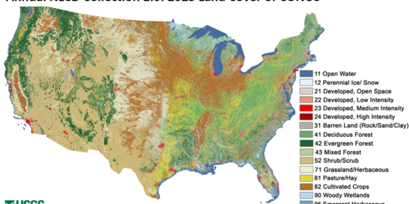
The Annual National Land Cover Database (NLCD) has harnessed the full Landsat data record to provide timely, long-term, and detailed land surface change information. Annual NLCD uses an ensemble of classification and change algorithms to map, monitor, and synthesize the complexities of land use, cover, and condition change through time.
Land Cover Trends

Land Cover Trends was a research project focused on understanding the rates, trends, causes, and consequences of contemporary U.S. land use and land cover change. The project spanned from 1999 to 2011.
National Land Cover Database

NLCD is generated in cooperation with the Multi-Resolution Land Characteristics Consortium (MRLC) a partnership of Federal agencies working together to produce current, nationally consistent, land cover products for all 50 states and Puerto Rico.
My primary interested and expertise is in using Landsat and other remotely sensed imagery in map creation and analyze spatial patterns. I am also the content manager for the Western Geographic Science Center.
I started my federal career with the Defense Mapping Agency (DMA) as a geographer in the Geographic Names Branch. I edited the names and legends of maps and charts plus translated the Germanic language maps into English.
As a cartographer with the National Oceanic and Atmospheric Administration (NOAA), I compiled nautical charts, working mainly in the Gulf of Mexico region of the United States.
When I joined the U.S. Geographic Survey (USGS), I started as an assistant supervisor for the Digital Orthophoto Quad (DOQ) program reviewing the completed DOQs. After transferring to Seattle, I have worked mainly on the Trends and National Land Cover Dataset (NLCD) projects, especially being a part of the accuracy assessment of the NLCD product. Currently my main project is working on the Annual National Land Cover Dataset (Annual NLCD).
Professional Experience
1998 - Current: Geographer, Western Geographic Science Center (WGSC)
1995 -1998: Cartographer, National Oceanic and Atmospheric Administration (NOAA)
1987 - 1990: Geographer, Defense Mapping Agency (DMA)
Education and Certifications
B.A. in Conservation, Geography and German, Carthage College
M.S. in Forestry with emphasis in remote sensing and computer cartography, University of Minnesota
Certificate in Geographic Information Systems, St. Cloud State University
Science and Products
LCMAP CONUS Reference Data Product 1984-2021 land cover, land use and change process attributes LCMAP CONUS Reference Data Product 1984-2021 land cover, land use and change process attributes
Thematic accuracy assessment of the National Land Cover Database (NLCD2021) for the conterminous United States Thematic accuracy assessment of the National Land Cover Database (NLCD2021) for the conterminous United States
Thematic accuracy assessment of the NLCD 2019 land cover for the conterminous United States Thematic accuracy assessment of the NLCD 2019 land cover for the conterminous United States
National Land Cover Database 2019: A comprehensive strategy for creating the 1986-2019 forest disturbance product National Land Cover Database 2019: A comprehensive strategy for creating the 1986-2019 forest disturbance product
Thematic accuracy assessment of the 2011 National Land Cover Database (NLCD) Thematic accuracy assessment of the 2011 National Land Cover Database (NLCD)
The Southern Piedmont’s continued land-use evolution, 1973–2011 The Southern Piedmont’s continued land-use evolution, 1973–2011
Land cover trends dataset, 1973-2000 Land cover trends dataset, 1973-2000
Eastern Cascades Slopes and Foothills Ecoregion: Chapter 12 in Status and trends of land change in the Western United States--1973 to 2000 Eastern Cascades Slopes and Foothills Ecoregion: Chapter 12 in Status and trends of land change in the Western United States--1973 to 2000
Cascades Ecoregion: Chapter 11 in Status and trends of land change in the Western United States--1973 to 2000 Cascades Ecoregion: Chapter 11 in Status and trends of land change in the Western United States--1973 to 2000
Willamette Valley Ecoregion: Chapter 3 in Status and trends of land change in the Western United States--1973 to 2000 Willamette Valley Ecoregion: Chapter 3 in Status and trends of land change in the Western United States--1973 to 2000
Puget Lowland Ecoregion: Chapter 2 in Status and trends of land change in the Western United States--1973 to 2000 Puget Lowland Ecoregion: Chapter 2 in Status and trends of land change in the Western United States--1973 to 2000
Non-USGS Publications**
https://doi.org/10.1016/j.rse.2021.112357
**Disclaimer: The views expressed in Non-USGS publications are those of the author and do not represent the views of the USGS, Department of the Interior, or the U.S. Government.