Dry Marsh Run at Rt. 645 bridge downstream of streamflow gaging station USGS 01616100 near Berryville.
Streamflow data for this site can be viewed on Water Data for the Nation here.

Official websites use .gov
A .gov website belongs to an official government organization in the United States.
Secure .gov websites use HTTPS
A lock () or https:// means you’ve safely connected to the .gov website. Share sensitive information only on official, secure websites.

Dry Marsh Run at Rt. 645 bridge downstream of streamflow gaging station USGS 01616100 near Berryville.
Streamflow data for this site can be viewed on Water Data for the Nation here.
Dry Marsh Run at Rt. 645 bridge downstream of streamflow gaging station USGS 01616100 near Berryville.
Streamflow data for this site can be viewed on Water Data for the Nation here.

Spout Run at Rt. 621 bridge upstream of streamflow gaging station USGS 01636316 near Millwood.
You can see streamflow data for this site at USGS Water Data for the Nation here.
Spout Run at Rt. 621 bridge upstream of streamflow gaging station USGS 01636316 near Millwood.
You can see streamflow data for this site at USGS Water Data for the Nation here.

Waterfall on Spout Run downstream of streamflow gaging station USGS 01636316 at Rt. 621 near Millwood
Waterfall on Spout Run downstream of streamflow gaging station USGS 01636316 at Rt. 621 near Millwood

Dry stream segment of Dry Marsh Run in the northwestern part of Clarke County, Virginia. Upstream of the Rt. 635 bridge.
This region of Clarke County is locally referred to as the "Arabian Plain".
Dry stream segment of Dry Marsh Run in the northwestern part of Clarke County, Virginia. Upstream of the Rt. 635 bridge.
This region of Clarke County is locally referred to as the "Arabian Plain".
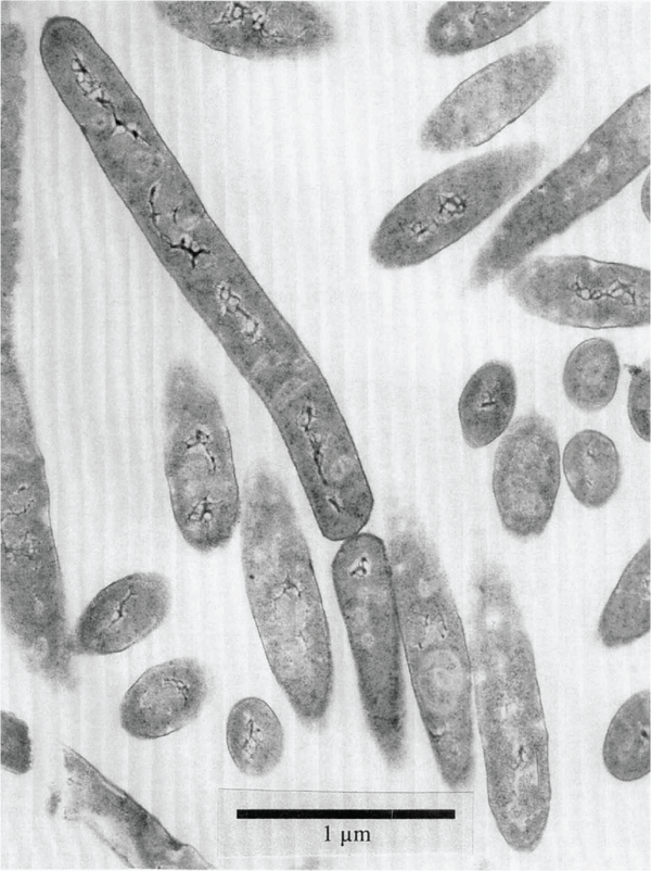
An electron-microscope image of a microbe (Bacillus infernus) found 2,700 meters (8,860 feet) underground in Virginia. From Boone et al., 1995 (https://doi.org/10.1099/00207713-45-3-441).
An electron-microscope image of a microbe (Bacillus infernus) found 2,700 meters (8,860 feet) underground in Virginia. From Boone et al., 1995 (https://doi.org/10.1099/00207713-45-3-441).

Under natural conditions, water levels in wells completed in many confined aquifers rise above the land surface, resulting in artesian flow. The well shown in the photograph was drilled near Franklin, Virginia, in 1941 to a depth of about 600 feet in confined aquifers. The initial water level in the well was about 7 feet above land surface.
Under natural conditions, water levels in wells completed in many confined aquifers rise above the land surface, resulting in artesian flow. The well shown in the photograph was drilled near Franklin, Virginia, in 1941 to a depth of about 600 feet in confined aquifers. The initial water level in the well was about 7 feet above land surface.

Damage to a house in Louisa County, Virginia, after a magnitude 5.8 earthquake on August 23, 2011.
Damage to a house in Louisa County, Virginia, after a magnitude 5.8 earthquake on August 23, 2011.

USGS geophysicist Anjana Shah stands next to a Cessna Grand Caravan airplane that took measurements over Virginia's Louisa, Goochland and Fluvanna counties. The data collected will help USGS scientists locate buried geologic features associated with the August 23, 2011 earthquake and its aftershocks. Surveys were conducted from 7/15- 7/25.
USGS geophysicist Anjana Shah stands next to a Cessna Grand Caravan airplane that took measurements over Virginia's Louisa, Goochland and Fluvanna counties. The data collected will help USGS scientists locate buried geologic features associated with the August 23, 2011 earthquake and its aftershocks. Surveys were conducted from 7/15- 7/25.

Damage to a house in Louisa County, Virginia, after a magnitude 5.8 earthquake on August 23, 2011.
Damage to a house in Louisa County, Virginia, after a magnitude 5.8 earthquake on August 23, 2011.

A Cessna Grand Caravan airplane took measurements over Virginia's Louisa, Goochland and Fluvanna counties. The data collected will help USGS scientists locate buried geologic features associated with the August 23, 2011 earthquake and its aftershocks. Surveys were conducted from 7/15- 7/25.
A Cessna Grand Caravan airplane took measurements over Virginia's Louisa, Goochland and Fluvanna counties. The data collected will help USGS scientists locate buried geologic features associated with the August 23, 2011 earthquake and its aftershocks. Surveys were conducted from 7/15- 7/25.

Damage to a house in Louisa County, Virginia, after a magnitude 5.8 earthquake on August 23, 2011.
Damage to a house in Louisa County, Virginia, after a magnitude 5.8 earthquake on August 23, 2011.

A Cessna Grand Caravan airplane took measurements over Virginia's Louisa, Goochland and Fluvanna counties. The data collected will help USGS scientists locate buried geologic features associated with the August 23, 2011 earthquake and its aftershocks. Surveys were conducted from 7/15- 7/25.
A Cessna Grand Caravan airplane took measurements over Virginia's Louisa, Goochland and Fluvanna counties. The data collected will help USGS scientists locate buried geologic features associated with the August 23, 2011 earthquake and its aftershocks. Surveys were conducted from 7/15- 7/25.

A Cessna Grand Caravan airplane took measurements over Virginia's Louisa, Goochland and Fluvanna counties. The data collected will help USGS scientists locate buried geologic features associated with the August 23, 2011 earthquake and its aftershocks. Surveys were conducted from 7/15- 7/25.
A Cessna Grand Caravan airplane took measurements over Virginia's Louisa, Goochland and Fluvanna counties. The data collected will help USGS scientists locate buried geologic features associated with the August 23, 2011 earthquake and its aftershocks. Surveys were conducted from 7/15- 7/25.

Chimney damage to a house in Louisa County, Virginia, after a magnitude 5.8 earthquake on August 23, 2011.
Chimney damage to a house in Louisa County, Virginia, after a magnitude 5.8 earthquake on August 23, 2011.