



Photograph of Lake Drummond, which is located within the Great Dismal Swamp in Virginia. USGS scientists recently collected peat and lake core samples from the swamp to help reconstruct natural environmental conditions over the past 12,000 years.
Images
Images intro.
Filter Total Items: 308

Great Dismal Swamp, Lake Drummond
Photograph of Lake Drummond, which is located within the Great Dismal Swamp in Virginia. USGS scientists recently collected peat and lake core samples from the swamp to help reconstruct natural environmental conditions over the past 12,000 years.
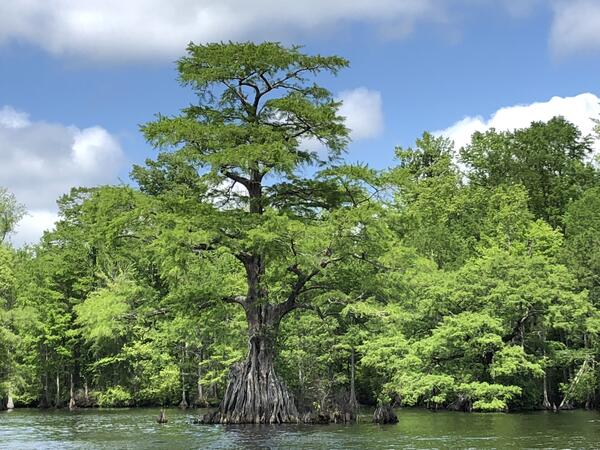
Cyprus Tree, Great Dismal Swamp, Lake Drummond, Virginia
Cyprus Tree, Great Dismal Swamp, Lake Drummond, VirginiaA cyprus tree in Lake Drummond, Great Dismal Swamp National Wildlife Refuge, Virginia
Cyprus Tree, Great Dismal Swamp, Lake Drummond, Virginia
Cyprus Tree, Great Dismal Swamp, Lake Drummond, VirginiaA cyprus tree in Lake Drummond, Great Dismal Swamp National Wildlife Refuge, Virginia

Great Dismal Swamp
Scientists are collecting core samples from the Great Dismal Swamp in Virginia to understand natural conditions before centuries of ditching, draining and harvesting. This is a collaborative project between the USGS and the Great Dismal Swamp National Wildlife Refuge.
Scientists are collecting core samples from the Great Dismal Swamp in Virginia to understand natural conditions before centuries of ditching, draining and harvesting. This is a collaborative project between the USGS and the Great Dismal Swamp National Wildlife Refuge.

The USGS Nansemond research station.
The USGS Nansemond research station, located adjacent to the Hampton Roads Sanitation District's SWIFT pilot site. The building contains the Nansemond extensometer.
The USGS Nansemond research station, located adjacent to the Hampton Roads Sanitation District's SWIFT pilot site. The building contains the Nansemond extensometer.

Great Dismal Swamp
Scientists are collecting core samples from the Great Dismal Swamp in Virginia to understand natural conditions before centuries of ditching, draining and harvesting. This is a collaborative project between the USGS and the Great Dismal Swamp National Wildlife Refuge.
Scientists are collecting core samples from the Great Dismal Swamp in Virginia to understand natural conditions before centuries of ditching, draining and harvesting. This is a collaborative project between the USGS and the Great Dismal Swamp National Wildlife Refuge.

Great Dismal Swamp
Scientists are collecting core samples from the Great Dismal Swamp in Virginia to understand natural conditions before centuries of ditching, draining and harvesting. This is a collaborative project between the USGS and the Great Dismal Swamp National Wildlife Refuge.
Scientists are collecting core samples from the Great Dismal Swamp in Virginia to understand natural conditions before centuries of ditching, draining and harvesting. This is a collaborative project between the USGS and the Great Dismal Swamp National Wildlife Refuge.

Great Dismal Swamp
Scientists are collecting core samples from the Great Dismal Swamp in Virginia to understand natural conditions before centuries of ditching, draining and harvesting. This is a collaborative project between the USGS and the Great Dismal Swamp National Wildlife Refuge.
Scientists are collecting core samples from the Great Dismal Swamp in Virginia to understand natural conditions before centuries of ditching, draining and harvesting. This is a collaborative project between the USGS and the Great Dismal Swamp National Wildlife Refuge.

The Great Dismal Swamp
Photograph of the Great Dismal Swamp in Virginia.
Photograph of the Great Dismal Swamp in Virginia.

Virginia Extensometer Drilling Site
This photograph shows the initial drilling for the borehole extensometer installed at the Nansemond, Virginia research site.
This photograph shows the initial drilling for the borehole extensometer installed at the Nansemond, Virginia research site.

USGS Nansemond drilling site.
This photograph shows the drilling site for the USGS Nansemond extensometer. The site is located adjacent to the Hampton Roads Sanitation District's SWIFT pilot site. The drilling would extend 1,960 feet below the ground surface.
This photograph shows the drilling site for the USGS Nansemond extensometer. The site is located adjacent to the Hampton Roads Sanitation District's SWIFT pilot site. The drilling would extend 1,960 feet below the ground surface.

Great Dismal Swamp
Scientists are collecting core samples from the Great Dismal Swamp in Virginia to understand natural conditions before centuries of ditching, draining and harvesting. This is a collaborative project between the USGS and the Great Dismal Swamp National Wildlife Refuge.
Scientists are collecting core samples from the Great Dismal Swamp in Virginia to understand natural conditions before centuries of ditching, draining and harvesting. This is a collaborative project between the USGS and the Great Dismal Swamp National Wildlife Refuge.

Great Dismal Swamp
Scientists are collecting core samples from the Great Dismal Swamp in Virginia to understand natural conditions before centuries of ditching, draining and harvesting. This is a collaborative project between the USGS and the Great Dismal Swamp National Wildlife Refuge.
Scientists are collecting core samples from the Great Dismal Swamp in Virginia to understand natural conditions before centuries of ditching, draining and harvesting. This is a collaborative project between the USGS and the Great Dismal Swamp National Wildlife Refuge.

Great Dismal Swamp
Scientists are collecting core samples from the Great Dismal Swamp in Virginia to understand natural conditions before centuries of ditching, draining and harvesting. This is a collaborative project between the USGS and the Great Dismal Swamp National Wildlife Refuge.
Scientists are collecting core samples from the Great Dismal Swamp in Virginia to understand natural conditions before centuries of ditching, draining and harvesting. This is a collaborative project between the USGS and the Great Dismal Swamp National Wildlife Refuge.

Great Dismal Swamp
Scientists are collecting core samples from the Great Dismal Swamp in Virginia to understand natural conditions before centuries of ditching, draining and harvesting. This is a collaborative project between the USGS and the Great Dismal Swamp National Wildlife Refuge.
Scientists are collecting core samples from the Great Dismal Swamp in Virginia to understand natural conditions before centuries of ditching, draining and harvesting. This is a collaborative project between the USGS and the Great Dismal Swamp National Wildlife Refuge.

Great Dismal Swamp
Scientists are collecting core samples from the Great Dismal Swamp in Virginia to understand natural conditions before centuries of ditching, draining and harvesting. This is a collaborative project between the USGS and the Great Dismal Swamp National Wildlife Refuge.
Scientists are collecting core samples from the Great Dismal Swamp in Virginia to understand natural conditions before centuries of ditching, draining and harvesting. This is a collaborative project between the USGS and the Great Dismal Swamp National Wildlife Refuge.

The Great Dismal Swamp
Photograph of the Great Dismal Swamp in Virginia.
Photograph of the Great Dismal Swamp in Virginia.

Great Dismal Swamp, 2018
Photograph of the Great Dismal Swamp in Virginia several years after the 2011 fire. USGS scientists recently collected peat and lake core samples from the swamp to help reconstruct natural environmental conditions over the past 12,000 years.
Photograph of the Great Dismal Swamp in Virginia several years after the 2011 fire. USGS scientists recently collected peat and lake core samples from the swamp to help reconstruct natural environmental conditions over the past 12,000 years.

The USGS Nansemond pipe extensometer.
The USGS Nansemond pipe extensometer (59D 39) showing the triangular table in green and the instrument bridge in yellow above the extensometer. The piers that support the table extend down 65 feet. The movement of the table relative to the extensometer is how land-surface movement is measured.
The USGS Nansemond pipe extensometer (59D 39) showing the triangular table in green and the instrument bridge in yellow above the extensometer. The piers that support the table extend down 65 feet. The movement of the table relative to the extensometer is how land-surface movement is measured.

The USGS Nansemond pipe extensometer
A photo of the USGS Nansemond pipe extensometer (59D 39) with a total depth of 1,960 feet.
A photo of the USGS Nansemond pipe extensometer (59D 39) with a total depth of 1,960 feet.

The USGS Nansemond research station
The USGS Nansemond research station.

Analog dial gage (left) and a digital linear potentiometer (right)
Analog dial gage (left) and a digital linear potentiometer (right)An analog dial gage (left) and a digital linear potentiometer (right with blue barrel) used to measure land-surface movement in response to aquifer system deformation at the USGS Nansemond extensometer.
Analog dial gage (left) and a digital linear potentiometer (right)
Analog dial gage (left) and a digital linear potentiometer (right)An analog dial gage (left) and a digital linear potentiometer (right with blue barrel) used to measure land-surface movement in response to aquifer system deformation at the USGS Nansemond extensometer.