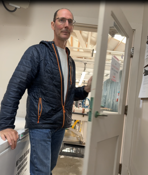
U.S. flag

An official website of the United States government

Images

Images intro.
Filter Total Items: 816
Underwater views of common fish inhabiting eelgrass meadows in Skagit Bay, Washington
Underwater Views of Common Fish Inhabiting Eelgrass Meadows in Skagit Bay, Washington

Explore the underwater world of Skagit Bay eelgrass meadows where a diverse group of fish are visible, including the elegant Pacific Herring school , the unusual Snake Prickleback, the striking Pacific Spiny Dogfish, the graceful Shiner Perch, and the majestic juvenile Chinook Salmon.

Explore the underwater world of Skagit Bay eelgrass meadows where a diverse group of fish are visible, including the elegant Pacific Herring school , the unusual Snake Prickleback, the striking Pacific Spiny Dogfish, the graceful Shiner Perch, and the majestic juvenile Chinook Salmon.

The new building of the Columbia River Research Laboratory
USGS WFRC Columbia River Research Laboratory

This is a photo of the new USGS Western Fisheries Research Center Columbia River Research Laboratory building.

Director and Western Fisheries Research Center staff in front of mural
Director Applegate and Staff from Western Fisheries Research Center

Director Applegate and staff from Western Fisheries Research Center pose in front of the newly painted mural at the Western Fisheries Research Center’s headquarters. The mural features three swimming salmon, a DNA helix, a microscope, and the USGS logo. 

Director Applegate and staff from Western Fisheries Research Center pose in front of the newly painted mural at the Western Fisheries Research Center’s headquarters. The mural features three swimming salmon, a DNA helix, a microscope, and the USGS logo. 

Director visits Western Fisheries Research Center Wet Lab
Director Visits Western Fisheries Research Center Wet Lab, 2024
Text says Mount St. Helens, Land of Transformation
Mount St. Helens: Land of Transformation

Mount St. Helens: Land of Transformation video shows the changes to the landscape from before the May 18, 1980 eruption to today (2024).

USGS Employees high five students participating in an outdoor lahar evacuation drill outside their school
Lahar Evacuation Drill

During the March 21, 2024 lahar evacuation drills, thousands of students walked to the Washington State Fairgrounds in Puyallup, Washington to practice evacuating from a lahar generated by Mount Rainier. A lahar, or volcanic mudflow, could reach this area in about 3 hours.

During the March 21, 2024 lahar evacuation drills, thousands of students walked to the Washington State Fairgrounds in Puyallup, Washington to practice evacuating from a lahar generated by Mount Rainier. A lahar, or volcanic mudflow, could reach this area in about 3 hours.

South Cascade Glacier timelapse
South Cascade Glacier area change, 1970 - 2021

South Cascade Glacier area change, 1970 - 2021.  South Cascade Glacier located in a north-northwest facing valley near the crest of the Cascade Range in northwest Washington state.

South Cascade Glacier area change, 1970 - 2021.  South Cascade Glacier located in a north-northwest facing valley near the crest of the Cascade Range in northwest Washington state.

A technician is suspended above a river by cableway. In the foreground, scientific equipment lays on the snow.
Measuring streamflow in the Pend Oreille River, WA

A hydrologic technician uses a cableway to measure streamflow in the Pend Oreille River on a winter day. On-shore, a computer shows streamflow data in real-time, allowing the team to monitor their progress.

A hydrologic technician uses a cableway to measure streamflow in the Pend Oreille River on a winter day. On-shore, a computer shows streamflow data in real-time, allowing the team to monitor their progress.

Vibrant UV light close-up image of a gloved hand holding a tray of glowing test samples.
New method to detect white-nose syndrome fungus in bats developed

A new test for white-nose syndrome-causing fungus in bats has been developed using a CRISPR biosensor. If white-nose syndrome-causing fungus is present, the reaction tube will glow under UV light.

A new test for white-nose syndrome-causing fungus in bats has been developed using a CRISPR biosensor. If white-nose syndrome-causing fungus is present, the reaction tube will glow under UV light.

Vibrant UV light close-up image of a tray of glowing test samples.
New method to detect white-nose syndrome fungus in bats developed

A new test for white-nose syndrome-causing fungus in bats has been developed using a CRISPR biosensor. If white-nose syndrome-causing fungus is present, the reaction tube will glow under UV light.

A new test for white-nose syndrome-causing fungus in bats has been developed using a CRISPR biosensor. If white-nose syndrome-causing fungus is present, the reaction tube will glow under UV light.

Map of western USA with colors indicating likelihood of hydrothermal activity
Map of areas predicted as having conditions favorable for fostering a hydrothermal system in the western United States

Map of areas predicted as having conditions favorable for fostering a hydrothermal system in the western United States.  Black dots are mapped hydrothermal systems.  From Mordensky et al., 2023 (https://www.sciencedirect.com/science/article/pii/S0375650523000160).

Scientist using a fluorescing stereoscope for counting microplastics
Scientist using a fluorescing stereoscope for counting microplastics found in smallmouth bass tissue samples

WFRC scientist Lisa Wetzel uses a fluorescing stereoscope to look for microplastics in samples of Smallmouth Bass tissue provided by the Nez Perce Tribe, Idaho.

Lighted bioacoustics fish fence in Georgiana Slough, CA
Georgiana Slough Bio-Acoustic Fish Fence (BAFF) Barrier

This is a drone photo of the bio-acoustic fish fence in the Georgiana Slough, a tributary of the Sacramento River Delta. It is used to guide fish safely out to the ocean.

This is a drone photo of the bio-acoustic fish fence in the Georgiana Slough, a tributary of the Sacramento River Delta. It is used to guide fish safely out to the ocean.

Visual abstract: Orange title, 2 images below on left with circular arrows. Arrow in middle going to 2 images circular arrows
Visual Abstract for Fire Modeling Integration

Workflow for integrating fire behavior modeling into post-fire hazard risk models. QUIC-Fire is a fast, 3-D simulation tool for prescribed fire planning. It can help managers understand the complex and dynamic behavior of wildland fires.

Workflow for integrating fire behavior modeling into post-fire hazard risk models. QUIC-Fire is a fast, 3-D simulation tool for prescribed fire planning. It can help managers understand the complex and dynamic behavior of wildland fires.

View of volcano monitoring station VALT in the crater of Mount St. Helens with rock-covered Crater Glacier nearby.
Volcano monitoring station VALT in 2023. Rock-covered Crater Glacier is nearby.

Monitoring station VALT, in the crater of Mount St. Helens, in 2023. Anxious about damage to the station from the advancing Crater Glacier (the rock and snow-covered cliff) and hazards to people working at the site, a CVO field team dismantled VALT on June 6, 2024 after 18 years in service. It will be rebuilt farther from the glacier. 

Monitoring station VALT, in the crater of Mount St. Helens, in 2023. Anxious about damage to the station from the advancing Crater Glacier (the rock and snow-covered cliff) and hazards to people working at the site, a CVO field team dismantled VALT on June 6, 2024 after 18 years in service. It will be rebuilt farther from the glacier. 

A dense patch of plants grows underwater
Elodea growth in Washington stream

Elodea and other aquatic plants grow in a thick clump in Clarks Creek, WA. Plants growing in streams may change the water chemistry as well as how quickly water can flow through the stream. USGS scientists study these dynamics.

Elodea and other aquatic plants grow in a thick clump in Clarks Creek, WA. Plants growing in streams may change the water chemistry as well as how quickly water can flow through the stream. USGS scientists study these dynamics.

A woman stands in a stream holding scientific equipment
Hydrologic technician measures streamflow in Tokul Creek

USGS Hydrologic Technician Katie Johnson measures streamflow in Tokul Creek near Snoqualmie, WA (12145000). 

WFRC scientists, Spokane fish health scientist and Spokane Tribal intern conduct virus exposures
WFRC scientists, Spokane fish health scientist and Spokane Tribal intern conduct virus exposures in the WFRC Seattle web lab
Was this page helpful?