
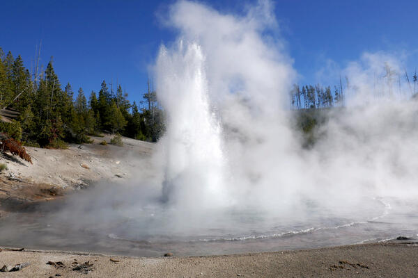
Echinus Geyser in eruption on October 24, 2017. Photo by MA Bellingham, used with permission.
Images
Images intro.
Filter Total Items: 709
Echinus Geyser in eruption in 2017
Echinus Geyser in eruption on October 24, 2017. Photo by MA Bellingham, used with permission.

View of the Silver Gate landslide complex from Bunsen Peak
View of the Silver Gate landslide complex from Bunsen PeakView of the Silver Gate landslide complex from Bunsen Peak in Yellowstone National Park. The landslide originates from Terrace Mountain.
View of the Silver Gate landslide complex from Bunsen Peak
View of the Silver Gate landslide complex from Bunsen PeakView of the Silver Gate landslide complex from Bunsen Peak in Yellowstone National Park. The landslide originates from Terrace Mountain.

Setting up to measure streamflow, Muddy Creek near Dad
Setting up to measure streamflow, Muddy Creek near DadSetting up to measure streamflow, Muddy Creek near Dad
Setting up to measure streamflow, Muddy Creek near Dad
Setting up to measure streamflow, Muddy Creek near DadSetting up to measure streamflow, Muddy Creek near Dad

Installing new radar sensor and staff plate, Big Sandy River
Installing new radar sensor and staff plate, Big Sandy RiverInstalling new radar sensor and staff plate, Big Sandy River
Installing new radar sensor and staff plate, Big Sandy River
Installing new radar sensor and staff plate, Big Sandy RiverInstalling new radar sensor and staff plate, Big Sandy River

Weir on a tributary flowing into Boundary Creek in southwest Yellowstone National Park
Weir on a tributary flowing into Boundary Creek in southwest Yellowstone National ParkA weir constructed by Irving Friedman and Dan Norton to measure water discharge and to monitor changes in hydrothermal activity on a tributary flowing into Boundary Creek in southwest Yellowstone National Park. USGS photo by Shaul Hurwitz, September 17, 2017.

Pipetting for DNA analysis - loop-mediated isothermal amplification
Pipetting for DNA analysis - loop-mediated isothermal amplificationPipetting for DNA analysis using loop-mediated isothermal amplification
Pipetting for DNA analysis - loop-mediated isothermal amplification
Pipetting for DNA analysis - loop-mediated isothermal amplificationPipetting for DNA analysis using loop-mediated isothermal amplification

Testing the feasibility of real-time eDNA monitoring
Testing the feasibility of real-time eDNA monitoringElk are not concerned with our work. USGS and the Monterey Bay Aquarium Research Institute conducted tests of the feasibility of real-time eDNA monitoring at USGS streamgage 06190540 Boiling River at Mammoth,YNP, September 13, 2017.

Teton Fault
Mark, Nicole, Rich, Ryan, Dean taking out the "trash" from the base of the trench.
Mark, Nicole, Rich, Ryan, Dean taking out the "trash" from the base of the trench.

Focal mechanism determined by moment tensor analysis on an M4.4 event in Yellowstone National Park in 2017
Focal mechanism determined by moment tensor analysis on an M4.4 event in Yellowstone National Park in 2017Focal mechanism determined by moment tensor analysis, which uses a model to fit the long-period (~10 s period or greater) ground motion records recorded at multiple locations.

Collecting sample for pesticide analyses, Big Horn River near Kane, WY
Collecting sample for pesticide analyses, Big Horn River near Kane, WYSample collection from cableway above Big Horn River near Kane, Wyoming as part of project evaluating pesticides in Wyoming.
Collecting sample for pesticide analyses, Big Horn River near Kane, WY
Collecting sample for pesticide analyses, Big Horn River near Kane, WYSample collection from cableway above Big Horn River near Kane, Wyoming as part of project evaluating pesticides in Wyoming.

Newly emerged adult wetsalts tiger beetle
A newly emerged adult wetsalts tiger beetle. Photo by Robert K. D. Peterson, 2017.
A newly emerged adult wetsalts tiger beetle. Photo by Robert K. D. Peterson, 2017.

Taking water-quality equipment to Fogarty Creek
Taking water-quality equipment to Fogarty Creek

Upright petrified tree in Yellowstone National Park
Upright petrified tree in Yellowstone National ParkUpright petrified tree in Yellowstone National Park.
Upright petrified tree in Yellowstone National Park
Upright petrified tree in Yellowstone National ParkUpright petrified tree in Yellowstone National Park.

Amphitheater Mountain and Soda Butte Creek Yellowstone
Amphitheater Mountain and Soda Butte Creek YellowstoneAmphitheater Mountain and Soda Butte Creek viewed from the Yellowstone National Park northeast entrance road.
Amphitheater Mountain and Soda Butte Creek Yellowstone
Amphitheater Mountain and Soda Butte Creek YellowstoneAmphitheater Mountain and Soda Butte Creek viewed from the Yellowstone National Park northeast entrance road.

Real-time well at Five Springs Creek southeast of Lovell, Wyoming
Real-time well at Five Springs Creek southeast of Lovell, WyomingReal-time well at Five Springs Creek southeast of Lovell, Wyoming
Real-time well at Five Springs Creek southeast of Lovell, Wyoming
Real-time well at Five Springs Creek southeast of Lovell, WyomingReal-time well at Five Springs Creek southeast of Lovell, Wyoming

Using a GPS station to get highly precise streamflow measurement
Using a GPS station to get highly precise streamflow measurementUsing a GPS station to get highly precise streamflow measurement
Using a GPS station to get highly precise streamflow measurement
Using a GPS station to get highly precise streamflow measurementUsing a GPS station to get highly precise streamflow measurement

Panoramic photo of the West Yellowstone rhyolite lava flow
Panoramic photo of the West Yellowstone rhyolite lava flowPanoramic of the West Yellowstone rhyolite lava flow taken along Highway 20 (between the West entrance of Yellowstone National Park and Madison Junction). The flow is approximately 111,000 years old and has a volume of about 41 km3 (10 mi3).

A geologist examples a basaltic lava flow along the Madison River
A geologist examples a basaltic lava flow along the Madison RiverA geologist examples a basaltic lava flow along the Madison River, looking for an area that can yield samples suitable for 40Ar/39Ar geochronology. USGS photo by Jorge Vazquez, June 2017.

Measuring streamflow using bridge crane, Powder River at Sussex
Measuring streamflow using bridge crane, Powder River at SussexMeasuring streamflow using bridge crane and AA meter, Powder River at Sussex
Measuring streamflow using bridge crane, Powder River at Sussex
Measuring streamflow using bridge crane, Powder River at SussexMeasuring streamflow using bridge crane and AA meter, Powder River at Sussex

Measuring stream stage on Muddy Creek near Dad
Measuring stream stage on Muddy Creek near Dad

Springtime streamflow measurement, East Fork Smiths Fork
Springtime streamflow measurement, East Fork Smiths ForkSpringtime streamflow measurement, East Fork Smiths Fork
Springtime streamflow measurement, East Fork Smiths Fork
Springtime streamflow measurement, East Fork Smiths ForkSpringtime streamflow measurement, East Fork Smiths Fork