
Streamflow measurement on Grouse Creek
Images
Images intro.
Filter Total Items: 708

Streamflow measurement on Grouse Creek

Littlefield Creek middle study site
Littlefield Creek middle study site

boulder dropped by retreating glacier in Yellowstone National Park
boulder dropped by retreating glacier in Yellowstone National ParkThis huge boulder was dropped by a retreating glacier on the north rim of the Grand Canyon of the Yellowstone in Yellowstone National Park, and it is a testament to Yellowstone's icy past.
By

Littlefield Creek middle study site
Littlefield Creek middle study site

Cistern Spring, Yellowstone National Park, both full and drained
Cistern Spring, Yellowstone National Park, both full and drainedPhotographs of Cistern Spring showing the draining behavior that occurs after major water eruptions of Steamboat Geyser. Left: about 2.5 hours after the onset of a major Steamboat eruption. Right: about 19.5 hours after that eruption.

Ice Measurement Equipment
Doppler is used to peer under the ice to "see" the flow in the Little Wind River near Riverton, Wyoming.
Doppler is used to peer under the ice to "see" the flow in the Little Wind River near Riverton, Wyoming.

Intern Using Doppler
One of our interns uses Dopplar to gather streamflow data through the ice at the Little Wind River near Riverton, Wyoming.
One of our interns uses Dopplar to gather streamflow data through the ice at the Little Wind River near Riverton, Wyoming.

Doppler through the ice
An intern uses Dopplar to gather streamflow data through the ice at the Little Wind River near Riverton, Wyoming.
An intern uses Dopplar to gather streamflow data through the ice at the Little Wind River near Riverton, Wyoming.

Clearing the Ice
Clearing the ice and snow to measure streamflow in South Fork Spread Creek.
Clearing the ice and snow to measure streamflow in South Fork Spread Creek.

NASA Yellowstone astrobiology team at Great Fountain Geyser
NASA Yellowstone astrobiology team at Great Fountain GeyserNASA Yellowstone astrobiology expedition team members stand in front of Great Fountain Geyser after completion of field work, February 28, 2019. Research conducted under Yellowstone Research Permit YELL-2019-SCI-8094.

Wyoming-Montana Stream Water-Quality Network Sites

New Fork River Sample Collection
We are using this piece of equipment to instantly measure stream temperature, pH, dissolved oxygen, and electrical conductivity. When you move the probe up and down in the water column, you can tell if the stream has stratification.
We are using this piece of equipment to instantly measure stream temperature, pH, dissolved oxygen, and electrical conductivity. When you move the probe up and down in the water column, you can tell if the stream has stratification.

Winter Streamflow
Using Doppler to peer under the ice and measure streamflow at New Fork River near Big Piney, Wyoming.
Using Doppler to peer under the ice and measure streamflow at New Fork River near Big Piney, Wyoming.

Employee Using an Ice Auger
A USGS employee uses a motorized auger to drill a two-foot hole in the ice for the purpose of measuring streamflow on the Sweetwater River. This image shows the final stages of the drilling process for one hole out of the twelve drilled that day.
A USGS employee uses a motorized auger to drill a two-foot hole in the ice for the purpose of measuring streamflow on the Sweetwater River. This image shows the final stages of the drilling process for one hole out of the twelve drilled that day.

Coring platform on the shore of Goose Lake, Lower Geyser Basin, Yellowstone National Park, in 2018
Coring platform on the shore of Goose Lake, Lower Geyser Basin, Yellowstone National Park, in 2018Coring platform assembled on the shore of Goose Lake, in Lower Geyser Basin, Yellowstone National Park, in 2018. Today, the nearest thermal features are 400 meters (about 1300 feet) away from Goose Lake, but thousands of years ago Goose Lake itself showed indications of being thermally active!. Steam from Midway Geyser Basin can be seen in the distance.

Hydrothermal sediment deposits from the Goose Lake (Yellowstone) sediment core
Hydrothermal sediment deposits from the Goose Lake (Yellowstone) sediment coreHydrothermal sediment deposits from the Goose Lake sediment core, Lower Geyser Basin, Yellowstone National Park. The orange sediment (left, scale in cm) consists mostly of fluorite, a common mineral in some hydrothermal deposits, but not usually found in lake sediments.
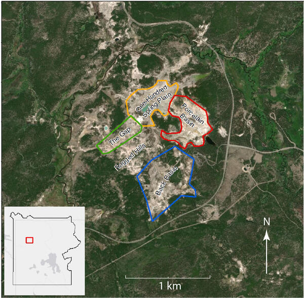
The four subbasins of Norris Geyser Basin, Yellowstone National Park
The four subbasins of Norris Geyser Basin, Yellowstone National ParkThe four subbasins of Norris Geyser Basin, Yellowstone National Park, as seen on a Google Earth base map. The curving line to the east of Norris Geyser Basin is the Grand Loop Road (Norris Junction is in the center-right of the image). Figure developed by Bill Keller, Yellowstone National Park.

National Oil and Gas Assessment Provinces
This is a graphic from the USGS National Oil and Gas Assessment Explorer application, which allows user to drill into 70 oil and gas assessment provinces throughout the United States.
This is a graphic from the USGS National Oil and Gas Assessment Explorer application, which allows user to drill into 70 oil and gas assessment provinces throughout the United States.

Wading Measurement on Leidy Creek
A USGS employee takes a wading measurement of streamflow on Leidy Creek at Togwotee Pass. Bear tracks on the fresh snow and seven grizzlie sightings were a good reminder to be bear-aware when taking measurements in this area.
A USGS employee takes a wading measurement of streamflow on Leidy Creek at Togwotee Pass. Bear tracks on the fresh snow and seven grizzlie sightings were a good reminder to be bear-aware when taking measurements in this area.
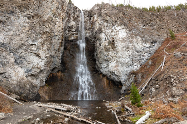
Fairy Falls, in Lower Geyser Basin, Yellowstone National Park

Bull Lake Creek Streamgage
Cross section wading measurement looking downstream at Bull Lake Creek above Bull Lake.
Cross section wading measurement looking downstream at Bull Lake Creek above Bull Lake.