
Cross section wading measurement looking downstream at Bull Lake Creek above Bull Lake.
Images
Images intro.
Filter Total Items: 709

Bull Lake Creek Streamgage
Cross section wading measurement looking downstream at Bull Lake Creek above Bull Lake.

Leidy Creek near Moran (13012465) streamgage
Leidy Creek near Moran (13012465) streamgage

South Fork Spread Creek near Moran (13012475) streamgage
South Fork Spread Creek near Moran (13012475) streamgageSouth Fork Spread Creek near Moran (13012475) streamgage
South Fork Spread Creek near Moran (13012475) streamgage
South Fork Spread Creek near Moran (13012475) streamgageSouth Fork Spread Creek near Moran (13012475) streamgage

Drainage area contributing to Big Creek below Lookout Creek, nr Apgar
Drainage area contributing to Big Creek below Lookout Creek, nr ApgarDrainage area contributing to Big Creek below Lookout Creek, near Apgar
Drainage area contributing to Big Creek below Lookout Creek, nr Apgar
Drainage area contributing to Big Creek below Lookout Creek, nr ApgarDrainage area contributing to Big Creek below Lookout Creek, near Apgar

Water Quality Sampling
Finishing up water-quality sampling on Blacks Fork, the last field run of the summer for two of our interns.
Finishing up water-quality sampling on Blacks Fork, the last field run of the summer for two of our interns.

Intern Learning Streamflow Measurement
Streamflow training at Blackrock Creek below Split Rock Creek near Moran, Wyoming. A new student intern learns how to measure streamflows upon arriving in Riverton just in time for high water.
Streamflow training at Blackrock Creek below Split Rock Creek near Moran, Wyoming. A new student intern learns how to measure streamflows upon arriving in Riverton just in time for high water.

Dragon's Mouth, Yellowstone National Park
Dragon’s Mouth in the Mud Volcano Area of Yellowstone National Park.
Dragon’s Mouth in the Mud Volcano Area of Yellowstone National Park.

Low Stage Streamflow Measurement
Measuring streamflow in Little Snake River near Dixon, Wyoming. Streamflows were quite a bit lower than the 75-year average.
Measuring streamflow in Little Snake River near Dixon, Wyoming. Streamflows were quite a bit lower than the 75-year average.

ADCP Bridge Measurement
An ADCP is used to measure streamflow from a bridge near Kelly, Wyoming. Even with smoke making the view hazy, the Tetons never fail to make measuring streamflow in the Gros Ventre a treat.
An ADCP is used to measure streamflow from a bridge near Kelly, Wyoming. Even with smoke making the view hazy, the Tetons never fail to make measuring streamflow in the Gros Ventre a treat.

Mushroom Pool, Lower Geyser Basin, Yellowstone National Park
Mushroom Pool, Lower Geyser Basin, Yellowstone National ParkMushroom Pool, Lower Geyser Basin, Yellowstone National Park.
Mushroom Pool, Lower Geyser Basin, Yellowstone National Park
Mushroom Pool, Lower Geyser Basin, Yellowstone National ParkMushroom Pool, Lower Geyser Basin, Yellowstone National Park.
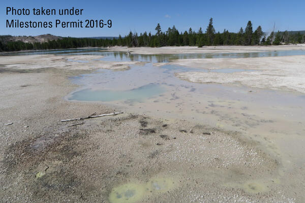
100 Spring Plain in Norris Geyser Basin, Yellowstone National Park
100 Spring Plain in Norris Geyser Basin, Yellowstone National Park100 Spring Plain in Norris Geyser Basin, Yellowstone National Park. The area is frequently flooded and impassable. Photo taken by Lauren Harrison in August 2018.
100 Spring Plain in Norris Geyser Basin, Yellowstone National Park
100 Spring Plain in Norris Geyser Basin, Yellowstone National Park100 Spring Plain in Norris Geyser Basin, Yellowstone National Park. The area is frequently flooded and impassable. Photo taken by Lauren Harrison in August 2018.

Thermally-deformed sensor recovered from the floor of Yellowstone Lake
Thermally-deformed sensor recovered from the floor of Yellowstone LakeSensor (top), deformed battery/electronics package (bottom), and titanium sheath (left) following recovery from vent location A in teh Deep Hole area on the floor of Yellowstone Lake.

Chemical/temperature sensor on the floor of Yellowstone Lake
Chemical/temperature sensor on the floor of Yellowstone LakeSensor (left) and battery/electronics package (right) at vent location A in the Deep Hole area of Yellowstone Lake. Photo was taken immediately before recovery from the lake floor. Notice the battery/electronics package slightly submerged in sediment.
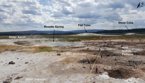
Electrical Resistivity Tomography (ERT) measurements near Rosette Spring, Yellowstone National Park
Electrical Resistivity Tomography (ERT) measurements near Rosette Spring, Yellowstone National ParkElectrical Resistivity Tomography (ERT) line R3 during setup of ERT and induced polarization measurement near Rosette Spring, Lower Geyser Basin. Photo by University of Wyoming Geophysics Team, July 17, 2018.

Lamar River Downstream View
This photo was taken within Yellowstone National Park and shows a cableway view of Lamar River near Tower Ranger Station. Less than half a mile downstream, the Lamar River flows into the more well-known Yellowstone River. When this photo was taken, flows were just a bit above average at the streamgage.
This photo was taken within Yellowstone National Park and shows a cableway view of Lamar River near Tower Ranger Station. Less than half a mile downstream, the Lamar River flows into the more well-known Yellowstone River. When this photo was taken, flows were just a bit above average at the streamgage.

Dropping the Wire Weight
The wire weight was dropped from this bridge to measure the stream stage of the Blacks Fork River near Lyman, Wyoming. Even with an early start, it is a struggle to get work done before an afternoon storm rolls in.
The wire weight was dropped from this bridge to measure the stream stage of the Blacks Fork River near Lyman, Wyoming. Even with an early start, it is a struggle to get work done before an afternoon storm rolls in.

Blacks Fork above Smiths Fork Streamgage
Blacks Fork above Smiths Fork Streamgage

ADCP Cableway Measurement
An exciting ride to get the ADCP to the main channel on the other side of the willows for streamflow measurement at the Shoshone River near Lovell, Wyoming.
An exciting ride to get the ADCP to the main channel on the other side of the willows for streamflow measurement at the Shoshone River near Lovell, Wyoming.

Collecting Water-Quality Sample Using Bridge Crane, Bighorn River
Collecting Water-Quality Sample Using Bridge Crane, Bighorn RiverSummer Interns learning about sampling at the Bighorn River near Worland, Wyoming. The team used the bridge crane and heavy sampler to get water while streamflow was about twice average for the date.

River Styx, Mammoth Hot Springs, Yellowstone National Park
River Styx, Mammoth Hot Springs, Yellowstone National ParkRiver Styx, Mammoth Hot Springs, Yellowstone National Park. This thermal feature is actually a subterranean hot water creek that likely collects water discharged from Mammoth Hot Spring pools that, after cooling and outflowing from vents, tends to disappear back underground through the porous travertine.

ADCP Bridge Measurement
USGS employees measuring WInd River streamflows at Kinnear bridge soon after minor flooding had occurred on the highway.
USGS employees measuring WInd River streamflows at Kinnear bridge soon after minor flooding had occurred on the highway.