



2023 Supplemental Appropriation Activities
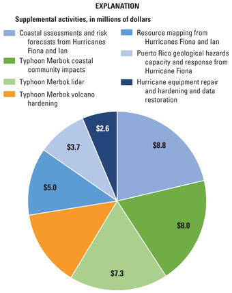
Title VII of Division N in the Consolidated Appropriations Act, 2023 (Public Law 117–328), was enacted on December 29, 2022. The USGS received $41.04 million in supplemental funding to support direct recovery and rebuilding decisions in the wake of declared disasters related to hurricanes and typhoons in 2022.
Specific activities funded in 2023
Media
Sources/Usage: Public Domain. View Media Details
USGS disaster emergency supplemental activities funded under the Consolidated Appropriations Act include:
- Hurricane Equipment Repair and Hardening and Data Restoration
- Coastal Assessments and Risk Forecasts from Hurricanes Fiona and Ian
- Puerto Rico Geological Hazards Capacity and Response
- Resource Mapping in Florida and Puerto Rico
- Typhoon Merbok Volcano Hardening
- Typhoon Merbok Coastal Community Impacts
- Lidar for Typhoon Merbok
Related
Filter Total Items: 19
Topobathymetric digital elevation models - coastal Alaska (ver. 2.0, March 2026) Topobathymetric digital elevation models - coastal Alaska (ver. 2.0, March 2026)
This data release consists of a series of seamless topobathymetric digital elevation models (TBDEMs) for coastal Alaskan communities. Each TBDEM was assembled from best available, multi-source topographic and bathymetric elevation data collected at the time of processing. These products were created to support the development of dynamic flood models, but are also intended for reuse by...
In situ field data, Coastal Alaska, 2023 to 2025 (ver. 2.0, March 2026) In situ field data, Coastal Alaska, 2023 to 2025 (ver. 2.0, March 2026)
These field data such as first floor elevation and bathymetric surveys were collected to support development of coastal mapping products and advance storm response and recovery in Alaskan coastal communities. The data consists of essential community infrastructure elevation data to better understand flood exposure and support analysis of flood mitigation solutions, bathymetric surveys to...
Thematic response frequency of user feedback on coastal science products Thematic response frequency of user feedback on coastal science products
Decision support tools play a critical role in assisting coastal decision-makers in managing coastal systems; yet there are challenges to developing tools that align with the functional needs of end-users. By combining usability testing and contextual inquiry methods, we put forth a hybrid approach for collecting user feedback within the context of federal government research. This...
Nearshore wave time-series along the coast of Alaska computed with a numerical wave model Nearshore wave time-series along the coast of Alaska computed with a numerical wave model
Alaska's Arctic coast has some of the highest erosion rates in the world. Erosion in the Arctic is primarily driven by permafrost thaw and wave activity. The warming climate decreases sea ice coverage, resulting in an increase in wave energy. To overcome the lack of available observational wave data in the nearshore, waves were downscaled with a numerical wave model (SWAN) utilizing...
Storm-Induced Overwash Extent Storm-Induced Overwash Extent
The Coastal Change Hazards Technical Capabilities and Applications project at the U.S. Geological Survey (USGS) exists to understand and predict storm impacts to our nation’s coastlines. This data release defines the alongshore extent of overwash deposits, determined from aerial photograph analysis, attributed to coastal processes during storm events. Note: This data release was...
Lidar-derived Beach Morphology (Dune Crest, Dune Toe, and Shoreline) for U.S. Sandy Coastlines Lidar-derived Beach Morphology (Dune Crest, Dune Toe, and Shoreline) for U.S. Sandy Coastlines
The U.S. Geological Survey (USGS)Coastal Change Hazards Technical Capabilities and Applications (TCA) project aims to identify areas of the nation’s coastline that are most vulnerable to extreme storms and long-term shoreline change. These assessments require coastal elevation data across diverse geographic regions and covering a time span of many years. The datasets published here...
Storm-Induced Coastal Change Forecasts: Archive of Individual Storm Events Storm-Induced Coastal Change Forecasts: Archive of Individual Storm Events
These data sets contain information on the probabilities of storm-induced erosion (collision, inundation and overwash) on sandy beaches along the U.S. Gulf and Atlantic coasts during real-time peak forecast conditions. The analysis is based on a storm-impact scaling model that uses observations of beach morphology combined with sophisticated hydrodynamic models to predict how the coast...
Consolidated Appropriations Act, 2023—USGS disaster emergency recovery activities Consolidated Appropriations Act, 2023—USGS disaster emergency recovery activities
Title VII of Division N in the Consolidated Appropriations Act, 2023 (Public Law 117–328), was enacted on December 29, 2022. The U.S. Geological Survey received $41.04 million in disaster emergency supplemental funding for repairing and replacing facilities and equipment, collecting high-resolution elevation data in affected areas, and completing scientific assessments to support direct...
Authors
Jo Ellen Hinck, Joseph Stachyra
Related
Filter Total Items: 19
Topobathymetric digital elevation models - coastal Alaska (ver. 2.0, March 2026) Topobathymetric digital elevation models - coastal Alaska (ver. 2.0, March 2026)
This data release consists of a series of seamless topobathymetric digital elevation models (TBDEMs) for coastal Alaskan communities. Each TBDEM was assembled from best available, multi-source topographic and bathymetric elevation data collected at the time of processing. These products were created to support the development of dynamic flood models, but are also intended for reuse by...
In situ field data, Coastal Alaska, 2023 to 2025 (ver. 2.0, March 2026) In situ field data, Coastal Alaska, 2023 to 2025 (ver. 2.0, March 2026)
These field data such as first floor elevation and bathymetric surveys were collected to support development of coastal mapping products and advance storm response and recovery in Alaskan coastal communities. The data consists of essential community infrastructure elevation data to better understand flood exposure and support analysis of flood mitigation solutions, bathymetric surveys to...
Thematic response frequency of user feedback on coastal science products Thematic response frequency of user feedback on coastal science products
Decision support tools play a critical role in assisting coastal decision-makers in managing coastal systems; yet there are challenges to developing tools that align with the functional needs of end-users. By combining usability testing and contextual inquiry methods, we put forth a hybrid approach for collecting user feedback within the context of federal government research. This...
Nearshore wave time-series along the coast of Alaska computed with a numerical wave model Nearshore wave time-series along the coast of Alaska computed with a numerical wave model
Alaska's Arctic coast has some of the highest erosion rates in the world. Erosion in the Arctic is primarily driven by permafrost thaw and wave activity. The warming climate decreases sea ice coverage, resulting in an increase in wave energy. To overcome the lack of available observational wave data in the nearshore, waves were downscaled with a numerical wave model (SWAN) utilizing...
Storm-Induced Overwash Extent Storm-Induced Overwash Extent
The Coastal Change Hazards Technical Capabilities and Applications project at the U.S. Geological Survey (USGS) exists to understand and predict storm impacts to our nation’s coastlines. This data release defines the alongshore extent of overwash deposits, determined from aerial photograph analysis, attributed to coastal processes during storm events. Note: This data release was...
Lidar-derived Beach Morphology (Dune Crest, Dune Toe, and Shoreline) for U.S. Sandy Coastlines Lidar-derived Beach Morphology (Dune Crest, Dune Toe, and Shoreline) for U.S. Sandy Coastlines
The U.S. Geological Survey (USGS)Coastal Change Hazards Technical Capabilities and Applications (TCA) project aims to identify areas of the nation’s coastline that are most vulnerable to extreme storms and long-term shoreline change. These assessments require coastal elevation data across diverse geographic regions and covering a time span of many years. The datasets published here...
Storm-Induced Coastal Change Forecasts: Archive of Individual Storm Events Storm-Induced Coastal Change Forecasts: Archive of Individual Storm Events
These data sets contain information on the probabilities of storm-induced erosion (collision, inundation and overwash) on sandy beaches along the U.S. Gulf and Atlantic coasts during real-time peak forecast conditions. The analysis is based on a storm-impact scaling model that uses observations of beach morphology combined with sophisticated hydrodynamic models to predict how the coast...
Consolidated Appropriations Act, 2023—USGS disaster emergency recovery activities Consolidated Appropriations Act, 2023—USGS disaster emergency recovery activities
Title VII of Division N in the Consolidated Appropriations Act, 2023 (Public Law 117–328), was enacted on December 29, 2022. The U.S. Geological Survey received $41.04 million in disaster emergency supplemental funding for repairing and replacing facilities and equipment, collecting high-resolution elevation data in affected areas, and completing scientific assessments to support direct...
Authors
Jo Ellen Hinck, Joseph Stachyra