
The B2cam captures a live view of Halemaʻumaʻu crater from the east rim and down-dropped block, looking west across Kīlauea summit caldera. On December 23, 2024, it captured the start of another Kīlauea summit eruption. USGS webcam image.
Images
Kīlauea images of eruptive activity, field work, and more.
Filter Total Items: 3126

December 23, 2024 - B2cam captures eruption start
The B2cam captures a live view of Halemaʻumaʻu crater from the east rim and down-dropped block, looking west across Kīlauea summit caldera. On December 23, 2024, it captured the start of another Kīlauea summit eruption. USGS webcam image.
December 23, 2024 — Kīlauea newest lava samples
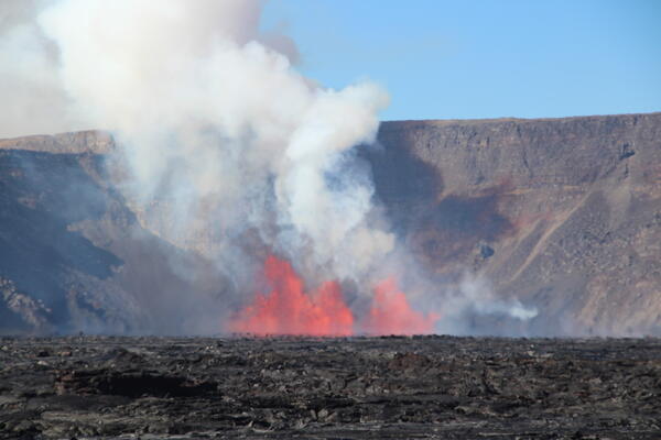
Around 2:20 a.m. HST on December 23, 2024, Kīlauea's newest summit eruption began in Halema‘uma‘u. Lava fountains overnight reached up to 90 meters (295 feet) high and threw molten lava up and onto portions of the old Crater Rim Drive in a closed area of Hawai‘i Volcanoes National Park.
Around 2:20 a.m. HST on December 23, 2024, Kīlauea's newest summit eruption began in Halema‘uma‘u. Lava fountains overnight reached up to 90 meters (295 feet) high and threw molten lava up and onto portions of the old Crater Rim Drive in a closed area of Hawai‘i Volcanoes National Park.
December 23, 2024 - Kīlauea summit eruption overflight
December 23, 2024 - Kīlauea summit eruption overflightDuring an overflight at approximately 9:30 a.m. HST, USGS Hawaiian Volcano Observatory geologists captured this view of the eruption that began this morning at 2:20 a.m. HST in Kaluapele (Kīlauea summit caldera).

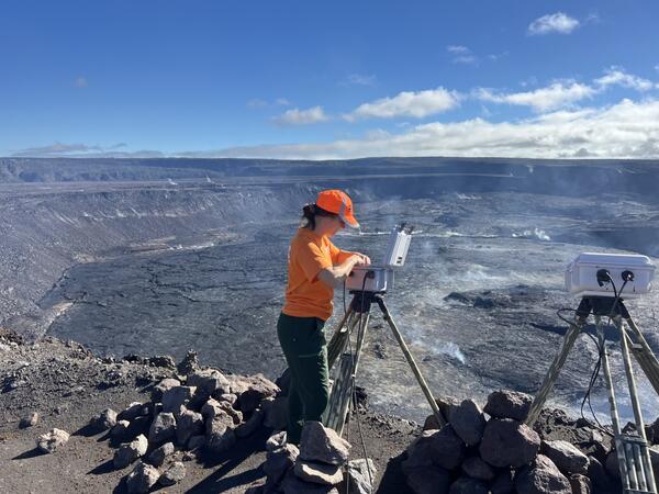
December 23, 2024 - USGS scientist checks volcano monitoring equipment
December 23, 2024 - USGS scientist checks volcano monitoring equipmentA USGS Hawaiian Volcano Observatory geologist checks a webcam located on the rim of Kīlauea caldera. The webcam network at the summit of Kīlauea volcano is crucial for monitoring eruptions such as the one that began today, December 23, 2024, in Hawaiʻi Volcanoes National Park. USGS image by M. Patrick.

December 23, 2024 - Collecting a lava sample
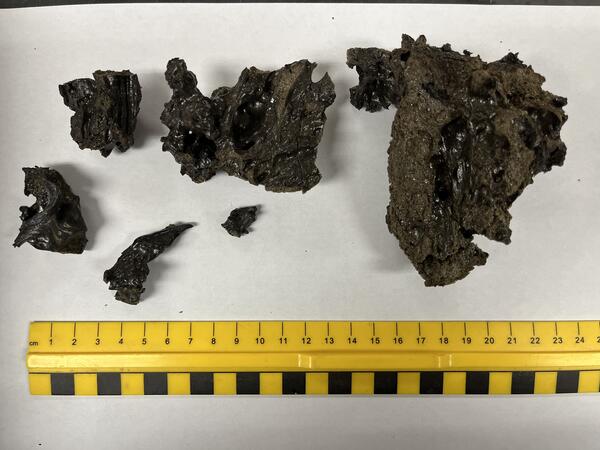
During an overflight at 2:30 p.m. HST today, December 23, USGS Hawaiian Volcano Observatory scientists were able to collect a molten sample of lava from the new eruption within Kaluapele. Kaluapele, the summit caldera of Kīlauea volcano, is the sacred home of the elemental force associated with volcanoes—Pele.
During an overflight at 2:30 p.m. HST today, December 23, USGS Hawaiian Volcano Observatory scientists were able to collect a molten sample of lava from the new eruption within Kaluapele. Kaluapele, the summit caldera of Kīlauea volcano, is the sacred home of the elemental force associated with volcanoes—Pele.

December 23, 2024 - View of the new eruption at the summit of Kīlauea
December 23, 2024 - View of the new eruption at the summit of KīlaueaThis photograph, taken at approximately 4:00 a.m. HST from the Volcano House overlook in Hawaiʻi Volcanoes National Park, shows the new eruption within Kaluapele (the summit caldera).

December 23, 2024 — Thermal map of eruption at Kīlauea summit
December 23, 2024 — Thermal map of eruption at Kīlauea summitThis thermal map shows lava flows covering the floor of Halemaʻumaʻu crater at the summit of Kīlauea. Fountaining was active in the southwest portion of the caldera, with flows extending east onto the downdropped block. Cooler colors (purple, black) show lower temperatures while hotter colors (orange, yellow) show higher temperatures. USGS map by M.
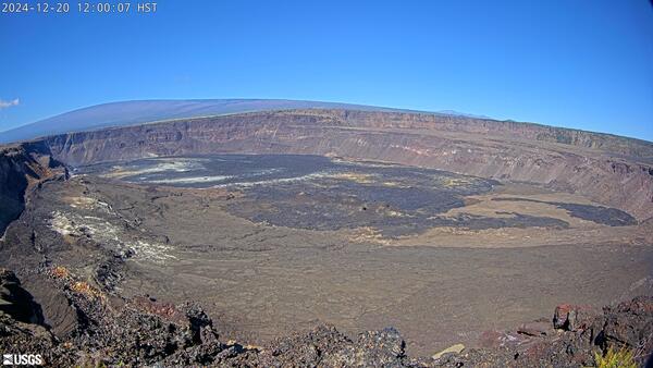
Kīlauea summit caldera from B1 camera on December 20, 2024
Kīlauea summit caldera from B1 camera on December 20, 2024View of Kaluapele (Kīlauea's summit caldera) from the B1 webcam on December 20, 2024, just before the onset of the episodic lava fountaining eruption on December 23.
Kīlauea summit caldera from B1 camera on December 20, 2024
Kīlauea summit caldera from B1 camera on December 20, 2024View of Kaluapele (Kīlauea's summit caldera) from the B1 webcam on December 20, 2024, just before the onset of the episodic lava fountaining eruption on December 23.
December 3, 2024 — Kīlauea Summit Webcam Maintenance
December 3, 2024 — Kīlauea Summit Webcam MaintenanceA HVO geologist inspected the KWcam enclosure for potential water entry points and found a weak seal. HVO staff will likely return in the future to make repairs to the enclosure or replace it all together. USGS photo by J. Barnett.

December 3, 2024 — Kīlauea Caldera, Kaluapele
The KWcam on the eastern rim of Kaluapele (Kīlauea caldera) has been sending blurry images due water condensation inside the camera enclosure. On December 3rd, 2024, HVO staff visited the webcam to dry out the enclosure and search for any perforations that may be the source of the leak. USGS photo by H. Winslow.
The KWcam on the eastern rim of Kaluapele (Kīlauea caldera) has been sending blurry images due water condensation inside the camera enclosure. On December 3rd, 2024, HVO staff visited the webcam to dry out the enclosure and search for any perforations that may be the source of the leak. USGS photo by H. Winslow.

December 3, 2024 — Kīlauea caldera camera maintenance
December 3, 2024 — Kīlauea caldera camera maintenanceHVO staff also visited the B1cam on the western side of Kaluapele (Kīlauea caldera) to remove water, replace desiccant packets, and clean off spider webs on the glass which were beginning to obscure the camera's view. USGS photo by H. Winslow.

December 3, 2024 — Kīlauea Caldera Floor
While servicing the B1cam, HVO staff captured this telephoto view of the cones that formed on the floor of Kaluapele (Kīlauea summit caldera) during the September 2023 summit eruption. USGS photo by H. Winslow.
While servicing the B1cam, HVO staff captured this telephoto view of the cones that formed on the floor of Kaluapele (Kīlauea summit caldera) during the September 2023 summit eruption. USGS photo by H. Winslow.
December 3, 2024 — Kīlauea Summit Webcam Maintenance
December 3, 2024 — Kīlauea Summit Webcam MaintenanceA HVO geologist inspected the KWcam enclosure for potential water entry points and found a weak seal. HVO staff will likely return in the future to make repairs to the enclosure or replace it all together. USGS photo by J. Barnett.
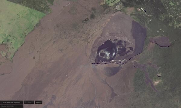
November 27, 2024 — Satellite image of Halemaʻumaʻu and Kaluapele at the summit of Kīlauea
November 27, 2024 — Satellite image of Halemaʻumaʻu and Kaluapele at the summit of KīlaueaSatellite image of Halemaʻumaʻu and Kaluapele at Kīlauea summit in Hawaiʻi Volcanoes National Park. This image was taken on November 27, 2024, before the episodic lava fountaining eruption in Halemaʻumaʻu began on December 23, 2024. Different-colored lava flows on the floor of Halemaʻumaʻu, Kaluapele, and around the caldera are different ages.
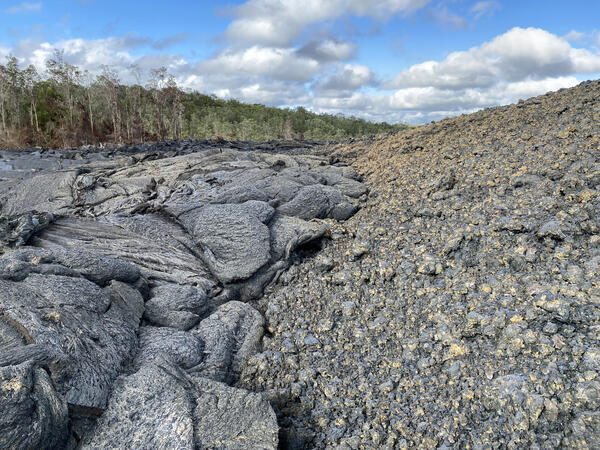
November 25, 2024 — Kīlauea September 2024 Lava Flow Edge
November 25, 2024 — Kīlauea September 2024 Lava Flow EdgeOn November 25, USGS Hawaiian Volcano Observatory geologists visited the site of the September 2024 eruption on Kīlauea’s East Rift Zone. Here, a shelly pāhoehoe lava flow (left) covered the base of a spatter cone (right) that grew around one of the lava fountains from an eruptive fissure vent. USGS photo taken by L. DeSmither.
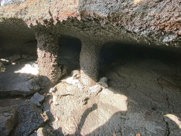
November 25, 2024 — Kīlauea September 2024 Lava Trees
November 25, 2024 — Kīlauea September 2024 Lava TreesA close-up view of two tree molds beneath the surface of a September 2024 Kīlauea East Rift Zone lava flow. Gas-rich lava flows near the September 2024 fissure vents created void spaces beneath the flow surface, which partially collapsed to reveal the base of these tree molds. USGS photo by L. DeSmither, taken on November 25, 2024.

November 25, 2024 — Kīlauea September 2024 Eruption Spatter
November 25, 2024 — Kīlauea September 2024 Eruption SpatterThis image shows spatter that was thrown up onto the Nāpau Crater trail to the northeast of the September 2024 middle East Rift Zone lava falls that spilled over the western rim of Nāpau Crater. Boot for scale. USGS photo by K. Lynn.

November 25, 2024 — Kīlauea September 2024 Eruption Lava Flows
November 25, 2024 — Kīlauea September 2024 Eruption Lava FlowsA USGS Hawaiian Volcano Observatory geologist observes a fissure from the September 15–20, 2024, Kīlauea East Rift Zone eruption that occurred in and near Nāpau Crater. This photo was taken on November 25, where the first fissure opened, uprift (west) of Nāpau Crater. Pu‘u‘ō‘ō is visible on the skyline in the upper right. USGS photo taken by L. DeSmither.

November 25, 2024 — Kīlauea September 2024 Eruption Tree Mold
November 25, 2024 — Kīlauea September 2024 Eruption Tree MoldA close-up view of a tree mold in a lava flow from the September 2024 Nāpau eruption. When the active lava flow came into contact with the tree, a mold was formed (black hole near center of photo). The high heat of the lava eventually burned through the base of the tree on the right side of the image causing it to fall on top of the newly emplaced lava flow.

November 25, 2024 — Kīlauea September 2024 Eruption Sample
November 25, 2024 — Kīlauea September 2024 Eruption SampleA USGS Hawaiian Volcano Observatory scientist uses a hammer to collect a sample from a cooled lava flow near the western end of the September 2024 Kīlauea East Rift Zone fissure system. On November 25, Hawaiian Volcano Observatory geologists visited the recent eruption area to collect lava samples and other data to further their studies of the eruption.

November 25, 2024 — Kīlauea September 2024 Eruption Lava Falls
November 25, 2024 — Kīlauea September 2024 Eruption Lava FallsOn November 25, 2024, USGS Hawaiian Volcano Observatory geologists surveyed the lava-draped west walls of Nāpau Crater. This view looks to the southwest and shows where the lava falls were vigorous enough to throw molten spatter over to the trail area. USGS photo by K. Lynn.