



On the left is a map with an upper inset showing the location of American Samoa in the South Pacific Ocean, a lower inset showing the overall volcano monitoring network of the territory, and the main map showing the topography and bathymetry of the Manua Islands along with the current monitoring network (unchanged since September 2025).
Multimedia
Multimedia of Taʻū Island in American Samoa.
Images
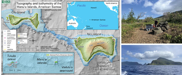
American Samoa volcano monitoring network
On the left is a map with an upper inset showing the location of American Samoa in the South Pacific Ocean, a lower inset showing the overall volcano monitoring network of the territory, and the main map showing the topography and bathymetry of the Manua Islands along with the current monitoring network (unchanged since September 2025).
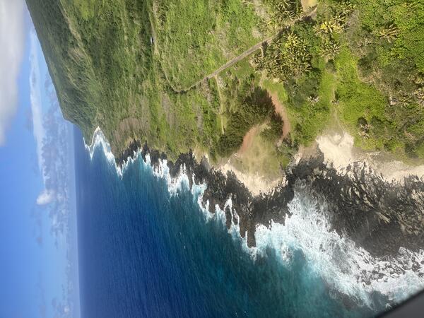
September 9, 2026 — Aerial view of the coast of eastern Ta‘ū Island, American Samoa
September 9, 2026 — Aerial view of the coast of eastern Ta‘ū Island, American SamoaThis photo, taken from an airplane, shows the eastern Ta‘ū Island coastline south of Fitiuta village; the view is from the north looking south. The black rock on the coast are lava flows of an unknown age. USGS photo by N. Deligne.
September 9, 2026 — Aerial view of the coast of eastern Ta‘ū Island, American Samoa
September 9, 2026 — Aerial view of the coast of eastern Ta‘ū Island, American SamoaThis photo, taken from an airplane, shows the eastern Ta‘ū Island coastline south of Fitiuta village; the view is from the north looking south. The black rock on the coast are lava flows of an unknown age. USGS photo by N. Deligne.
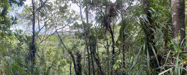
September 8, 2026 — Panorama of Judds Crater on Ta‘ū Island, American Samoa
September 8, 2026 — Panorama of Judds Crater on Ta‘ū Island, American SamoaThis panorama photo shows the heavily vegetated Judds Crater from the north looking south on eastern Ta‘ū Island in American Samoa.
September 8, 2026 — Panorama of Judds Crater on Ta‘ū Island, American Samoa
September 8, 2026 — Panorama of Judds Crater on Ta‘ū Island, American SamoaThis panorama photo shows the heavily vegetated Judds Crater from the north looking south on eastern Ta‘ū Island in American Samoa.
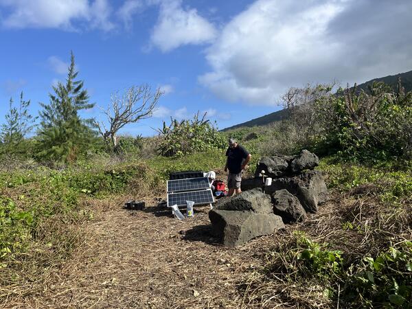
September 4, 2026 – Servicing seismic station on Taʻū Island, American Samoa
September 4, 2026 – Servicing seismic station on Taʻū Island, American SamoaA USGS Hawaiian Volcano Observatory seismologist services the FAGA seismic station on eastern Taʻū Island, American Samoa. This station is part of the volcano monitoring network of American Samoa, and is also used by the USGS National Earthquake Information Center (NEIC) and by the NOAA Pacific Tsunami Warning Center (PTWC). USGS photo by N. Deligne.
September 4, 2026 – Servicing seismic station on Taʻū Island, American Samoa
September 4, 2026 – Servicing seismic station on Taʻū Island, American SamoaA USGS Hawaiian Volcano Observatory seismologist services the FAGA seismic station on eastern Taʻū Island, American Samoa. This station is part of the volcano monitoring network of American Samoa, and is also used by the USGS National Earthquake Information Center (NEIC) and by the NOAA Pacific Tsunami Warning Center (PTWC). USGS photo by N. Deligne.
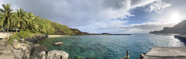
September 2, 2026 — Panorama of Faleāsao harbor on Ta‘ū Island
September 2, 2026 — Panorama of Faleāsao harbor on Ta‘ū IslandPanorama of Faleāsao village harbor on northwest Ta‘ū island, looking primarily north. This harbor is situated within a tuff cone that is thousands of years old, formed when hot magma interacted with either shallow groundwater or sea water. There are several tuff cones located within the northwest corner of Ta‘ū island. USGS photo by N. Deligne.
September 2, 2026 — Panorama of Faleāsao harbor on Ta‘ū Island
September 2, 2026 — Panorama of Faleāsao harbor on Ta‘ū IslandPanorama of Faleāsao village harbor on northwest Ta‘ū island, looking primarily north. This harbor is situated within a tuff cone that is thousands of years old, formed when hot magma interacted with either shallow groundwater or sea water. There are several tuff cones located within the northwest corner of Ta‘ū island. USGS photo by N. Deligne.
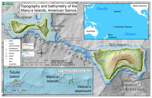
September 2025—Topography and bathymetry of the Manuʻa Islands, American Samoa
September 2025—Topography and bathymetry of the Manuʻa Islands, American SamoaThis reference map depicts the volcanoes of the Manuʻa Islands, American Samoa, which are monitored by the USGS Hawaiian Volcano Observatory.
September 2025—Topography and bathymetry of the Manuʻa Islands, American Samoa
September 2025—Topography and bathymetry of the Manuʻa Islands, American SamoaThis reference map depicts the volcanoes of the Manuʻa Islands, American Samoa, which are monitored by the USGS Hawaiian Volcano Observatory.
Audio
Volcano Minute — Volcano monitoring work in American Samoa: aloha to talofa
Volcano Minute — Volcano monitoring work in American Samoa: aloha to talofaThe Volcano Minute is a brief audio update about eruptions, earthquakes, or ongoing volcano science in Hawaii, brought to you by scientists and affiliates of the U.S. Geological Survey Hawaiian Volcano Observatory.
Volcano Minute — Volcano monitoring work in American Samoa: aloha to talofa
Volcano Minute — Volcano monitoring work in American Samoa: aloha to talofaThe Volcano Minute is a brief audio update about eruptions, earthquakes, or ongoing volcano science in Hawaii, brought to you by scientists and affiliates of the U.S. Geological Survey Hawaiian Volcano Observatory.