



On the left is a map with an upper inset showing the location of American Samoa in the South Pacific Ocean, a lower inset showing the overall volcano monitoring network of the territory, and the main map showing the topography and bathymetry of the Manua Islands along with the current monitoring network (unchanged since September 2025).
Images
Images of Taʻū Island in American Samoa.
Filter Total Items: 40
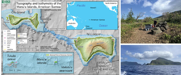
American Samoa volcano monitoring network
On the left is a map with an upper inset showing the location of American Samoa in the South Pacific Ocean, a lower inset showing the overall volcano monitoring network of the territory, and the main map showing the topography and bathymetry of the Manua Islands along with the current monitoring network (unchanged since September 2025).
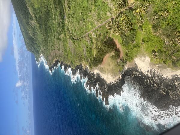
September 9, 2026 — Aerial view of the coast of eastern Ta‘ū Island, American Samoa
September 9, 2026 — Aerial view of the coast of eastern Ta‘ū Island, American SamoaThis photo, taken from an airplane, shows the eastern Ta‘ū Island coastline south of Fitiuta village; the view is from the north looking south. The black rock on the coast are lava flows of an unknown age. USGS photo by N. Deligne.
September 9, 2026 — Aerial view of the coast of eastern Ta‘ū Island, American Samoa
September 9, 2026 — Aerial view of the coast of eastern Ta‘ū Island, American SamoaThis photo, taken from an airplane, shows the eastern Ta‘ū Island coastline south of Fitiuta village; the view is from the north looking south. The black rock on the coast are lava flows of an unknown age. USGS photo by N. Deligne.
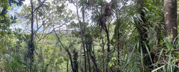
September 8, 2026 — Panorama of Judds Crater on Ta‘ū Island, American Samoa
September 8, 2026 — Panorama of Judds Crater on Ta‘ū Island, American SamoaThis panorama photo shows the heavily vegetated Judds Crater from the north looking south on eastern Ta‘ū Island in American Samoa.
September 8, 2026 — Panorama of Judds Crater on Ta‘ū Island, American Samoa
September 8, 2026 — Panorama of Judds Crater on Ta‘ū Island, American SamoaThis panorama photo shows the heavily vegetated Judds Crater from the north looking south on eastern Ta‘ū Island in American Samoa.
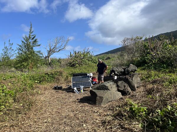
September 4, 2026 – Servicing seismic station on Taʻū Island, American Samoa
September 4, 2026 – Servicing seismic station on Taʻū Island, American SamoaA USGS Hawaiian Volcano Observatory seismologist services the FAGA seismic station on eastern Taʻū Island, American Samoa. This station is part of the volcano monitoring network of American Samoa, and is also used by the USGS National Earthquake Information Center (NEIC) and by the NOAA Pacific Tsunami Warning Center (PTWC). USGS photo by N. Deligne.
September 4, 2026 – Servicing seismic station on Taʻū Island, American Samoa
September 4, 2026 – Servicing seismic station on Taʻū Island, American SamoaA USGS Hawaiian Volcano Observatory seismologist services the FAGA seismic station on eastern Taʻū Island, American Samoa. This station is part of the volcano monitoring network of American Samoa, and is also used by the USGS National Earthquake Information Center (NEIC) and by the NOAA Pacific Tsunami Warning Center (PTWC). USGS photo by N. Deligne.
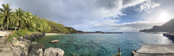
September 2, 2026 — Panorama of Faleāsao harbor on Ta‘ū Island
September 2, 2026 — Panorama of Faleāsao harbor on Ta‘ū IslandPanorama of Faleāsao village harbor on northwest Ta‘ū island, looking primarily north. This harbor is situated within a tuff cone that is thousands of years old, formed when hot magma interacted with either shallow groundwater or sea water. There are several tuff cones located within the northwest corner of Ta‘ū island. USGS photo by N. Deligne.
September 2, 2026 — Panorama of Faleāsao harbor on Ta‘ū Island
September 2, 2026 — Panorama of Faleāsao harbor on Ta‘ū IslandPanorama of Faleāsao village harbor on northwest Ta‘ū island, looking primarily north. This harbor is situated within a tuff cone that is thousands of years old, formed when hot magma interacted with either shallow groundwater or sea water. There are several tuff cones located within the northwest corner of Ta‘ū island. USGS photo by N. Deligne.
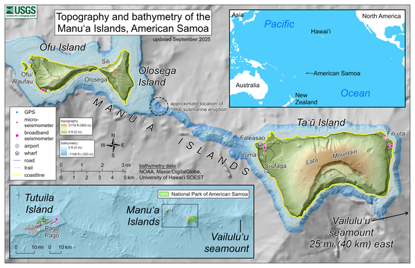
September 2025—Topography and bathymetry of the Manuʻa Islands, American Samoa
September 2025—Topography and bathymetry of the Manuʻa Islands, American SamoaThis reference map depicts the volcanoes of the Manuʻa Islands, American Samoa, which are monitored by the USGS Hawaiian Volcano Observatory.
September 2025—Topography and bathymetry of the Manuʻa Islands, American Samoa
September 2025—Topography and bathymetry of the Manuʻa Islands, American SamoaThis reference map depicts the volcanoes of the Manuʻa Islands, American Samoa, which are monitored by the USGS Hawaiian Volcano Observatory.
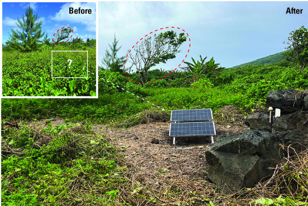
Broadband seismometer site on eastern Taʻū, American Samoa, before and after it was cleared of vegetation.
Broadband seismometer site on eastern Taʻū, American Samoa, before and after it was cleared of vegetation.Broadband seismometer site on eastern Taʻū, American Samoa, before (inset) and after a work party cleared rapidly growing vegetation which had covered the solar panels along with the boulders to the right of the main photo. Due to lack of power from the solar panels being unable to charge during the day, the station was offline for many months.
Broadband seismometer site on eastern Taʻū, American Samoa, before and after it was cleared of vegetation.
Broadband seismometer site on eastern Taʻū, American Samoa, before and after it was cleared of vegetation.Broadband seismometer site on eastern Taʻū, American Samoa, before (inset) and after a work party cleared rapidly growing vegetation which had covered the solar panels along with the boulders to the right of the main photo. Due to lack of power from the solar panels being unable to charge during the day, the station was offline for many months.
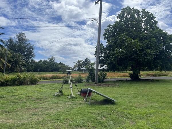
September 3, 2025 – Volcano monitoring GPS station on TAU Island, American Samoa
September 3, 2025 – Volcano monitoring GPS station on TAU Island, American SamoaPhoto of the USGS Global Positioning System (GPS) monitoring station on western Ta‘ū Island in the Manuʻa Islands of American Samoa. The station consists of a GPS unit, which can measure very slight movements of the ground, placed on a tripod that is leveled and centered over a benchmark.
September 3, 2025 – Volcano monitoring GPS station on TAU Island, American Samoa
September 3, 2025 – Volcano monitoring GPS station on TAU Island, American SamoaPhoto of the USGS Global Positioning System (GPS) monitoring station on western Ta‘ū Island in the Manuʻa Islands of American Samoa. The station consists of a GPS unit, which can measure very slight movements of the ground, placed on a tripod that is leveled and centered over a benchmark.

August 7, 2023 — View of the northwest side of Taʻū Island, American Samoa
August 7, 2023 — View of the northwest side of Taʻū Island, American SamoaA view of the northwest side of Taʻū Island in American Samoa. This island is a shield volcano with small scoria cones on its upper flanks and tuff cones at sea level. The history of this volcano is currently being studied to better understand the eruptions that built it. The light brown material in the foreground at sea level is part of a tuff cone at Faleāsao.
August 7, 2023 — View of the northwest side of Taʻū Island, American Samoa
August 7, 2023 — View of the northwest side of Taʻū Island, American SamoaA view of the northwest side of Taʻū Island in American Samoa. This island is a shield volcano with small scoria cones on its upper flanks and tuff cones at sea level. The history of this volcano is currently being studied to better understand the eruptions that built it. The light brown material in the foreground at sea level is part of a tuff cone at Faleāsao.

July 2023—Topography and bathymetry of the Manuʻa Islands, American Samoa
July 2023—Topography and bathymetry of the Manuʻa Islands, American SamoaThis reference map depicts the volcanoes in the Manuʻa Islands, American Samoa, the site of seismic unrest between July and September 2022. Marked on the map are the locations of Hawaiian Volcano Observatory GPS and seismometers in the islands.
July 2023—Topography and bathymetry of the Manuʻa Islands, American Samoa
July 2023—Topography and bathymetry of the Manuʻa Islands, American SamoaThis reference map depicts the volcanoes in the Manuʻa Islands, American Samoa, the site of seismic unrest between July and September 2022. Marked on the map are the locations of Hawaiian Volcano Observatory GPS and seismometers in the islands.

Map of American Samoa volcano-monitoring network.
Map of the American Samoa volcano-monitoring network (top). Data from Wake Island hydrograph (located about 4,500 km, or 2,900 miles, northwest of Taʻū Island) shows the general trend in the number of events during the 2022 earthquake swarm (bottom left). Locations for larger earthquakes (M2.5 and greater) are available starting August 20, 2022 (bottom right).
Map of the American Samoa volcano-monitoring network (top). Data from Wake Island hydrograph (located about 4,500 km, or 2,900 miles, northwest of Taʻū Island) shows the general trend in the number of events during the 2022 earthquake swarm (bottom left). Locations for larger earthquakes (M2.5 and greater) are available starting August 20, 2022 (bottom right).

Bathymetric data from the National Oceanic and Atmospheric Administration (NOAA) collected around American Samoa
Bathymetric data from the National Oceanic and Atmospheric Administration (NOAA) collected around American SamoaBathymetric data from the National Oceanic and Atmospheric Administration (NOAA) collected around American Samoa. Light gray areas are the islands of Tutuila, Ofu-Olosega, and Taʻū. Black lines are 1,640 ft (500 m) contour intervals below sea level.
Bathymetric data from the National Oceanic and Atmospheric Administration (NOAA) collected around American Samoa
Bathymetric data from the National Oceanic and Atmospheric Administration (NOAA) collected around American SamoaBathymetric data from the National Oceanic and Atmospheric Administration (NOAA) collected around American Samoa. Light gray areas are the islands of Tutuila, Ofu-Olosega, and Taʻū. Black lines are 1,640 ft (500 m) contour intervals below sea level.

September 8, 2022 — Ta‘ū Island Coastal Tuff Cone
On the northwest coast of Ta‘ū Island (near Faleāsao village), half of a tuff cone, which is likely thousands of years old, is visible. Ocean waves have eroded away the other half of the tuff cone, which formed when hot magma interacted with either shallow groundwater or sea water. USGS image by J. Chang.
On the northwest coast of Ta‘ū Island (near Faleāsao village), half of a tuff cone, which is likely thousands of years old, is visible. Ocean waves have eroded away the other half of the tuff cone, which formed when hot magma interacted with either shallow groundwater or sea water. USGS image by J. Chang.

September 8, 2022 — Ta‘ū Island Coastal Tuff Cone
The tuff cone on the northwest coast of Ta‘ū Island (near Faleāsao village) is mostly composed of fine-grained ash with larger lithic clasts (fragments of older rock material). Some of these lithic clasts are larger than 1 meter or 3 feet in diameter and are scattered throughout the tuff cone. USGS image by J. Chang.
The tuff cone on the northwest coast of Ta‘ū Island (near Faleāsao village) is mostly composed of fine-grained ash with larger lithic clasts (fragments of older rock material). Some of these lithic clasts are larger than 1 meter or 3 feet in diameter and are scattered throughout the tuff cone. USGS image by J. Chang.

September 7, 2022 — USGS Installs GPS Stations on Ta‘ū Island in American Samoa
September 7, 2022 — USGS Installs GPS Stations on Ta‘ū Island in American SamoaUSGS staff are on Ta‘ū Island in American Samoa to begin installing Global Positioning System (GPS) receiver monitoring sites. GPS equipment is able to detect very slight movements of the ground and will help the USGS to better understand what is happening beneath the ground and provide more accurate hazard assessments. USGS image by J. Chang.
September 7, 2022 — USGS Installs GPS Stations on Ta‘ū Island in American Samoa
September 7, 2022 — USGS Installs GPS Stations on Ta‘ū Island in American SamoaUSGS staff are on Ta‘ū Island in American Samoa to begin installing Global Positioning System (GPS) receiver monitoring sites. GPS equipment is able to detect very slight movements of the ground and will help the USGS to better understand what is happening beneath the ground and provide more accurate hazard assessments. USGS image by J. Chang.

September 7, 2022 — USGS Installs GPS Stations on Ta‘ū Island in American Samoa
September 7, 2022 — USGS Installs GPS Stations on Ta‘ū Island in American SamoaA USGS scientist checks the power supply at a Global Positioning System (GPS) station on Ta‘ū Island in American Samoa. The station consists of a GPS unit, which can measure changes in ground motion, placed on a tripod that is leveled and centered over a benchmark.
September 7, 2022 — USGS Installs GPS Stations on Ta‘ū Island in American Samoa
September 7, 2022 — USGS Installs GPS Stations on Ta‘ū Island in American SamoaA USGS scientist checks the power supply at a Global Positioning System (GPS) station on Ta‘ū Island in American Samoa. The station consists of a GPS unit, which can measure changes in ground motion, placed on a tripod that is leveled and centered over a benchmark.

September 7, 2022 — USGS Installs GPS Stations on Ta‘ū Island in American Samoa
September 7, 2022 — USGS Installs GPS Stations on Ta‘ū Island in American SamoaPhotograph of a Global Positioning System (GPS) station on Ta‘ū Island in American Samoa. Solar panels and batteries in a weather-proof enclosure power the station, which consists of a GPS unit placed on a tripod that is leveled and centered over a benchmark.
September 7, 2022 — USGS Installs GPS Stations on Ta‘ū Island in American Samoa
September 7, 2022 — USGS Installs GPS Stations on Ta‘ū Island in American SamoaPhotograph of a Global Positioning System (GPS) station on Ta‘ū Island in American Samoa. Solar panels and batteries in a weather-proof enclosure power the station, which consists of a GPS unit placed on a tripod that is leveled and centered over a benchmark.

Map showing location of Ta'ū volcano in American Samoa and Wake Island
Map showing location of Ta'ū volcano in American Samoa and Wake IslandWake Island is about 2,800 miles (4,500 km) northwest of Ta'ū volcano in American Samoa. Both are located in the Pacific Ocean.
Map showing location of Ta'ū volcano in American Samoa and Wake Island
Map showing location of Ta'ū volcano in American Samoa and Wake IslandWake Island is about 2,800 miles (4,500 km) northwest of Ta'ū volcano in American Samoa. Both are located in the Pacific Ocean.

Topography, bathymetry, and volcano monitoring network of the Manu‘a Islands, American Samoa
Topography, bathymetry, and volcano monitoring network of the Manu‘a Islands, American SamoaThis reference map depicts the topography and bathymetry of the volcanoes in the Manu‘a Islands, American Samoa. The highest elevation in the area is Lata Mountain on Ta‘ū Island, standing 3,179 feet (969 meters) above sea level.
Topography, bathymetry, and volcano monitoring network of the Manu‘a Islands, American Samoa
Topography, bathymetry, and volcano monitoring network of the Manu‘a Islands, American SamoaThis reference map depicts the topography and bathymetry of the volcanoes in the Manu‘a Islands, American Samoa. The highest elevation in the area is Lata Mountain on Ta‘ū Island, standing 3,179 feet (969 meters) above sea level.

August 30, 2022 — Collecting Rock Samples on Ta‘ū Island
August 30, 2022 — Collecting Rock Samples on Ta‘ū IslandA USGS Hawaiian Volcano Observatory geologist collects a rock sample using a rock hammer on Ta‘ū Island, American Samoa. HVO staff are in American Samoa responding to earthquake activity. While there to install monitoring instrumentation, they are also collecting rock samples to better understand past volcanic activity in American Samoa. USGS image by J. Chang.
August 30, 2022 — Collecting Rock Samples on Ta‘ū Island
August 30, 2022 — Collecting Rock Samples on Ta‘ū IslandA USGS Hawaiian Volcano Observatory geologist collects a rock sample using a rock hammer on Ta‘ū Island, American Samoa. HVO staff are in American Samoa responding to earthquake activity. While there to install monitoring instrumentation, they are also collecting rock samples to better understand past volcanic activity in American Samoa. USGS image by J. Chang.

August 30, 2022 — Collecting Rock Samples on Ta‘ū Island
August 30, 2022 — Collecting Rock Samples on Ta‘ū IslandA USGS Hawaiian Volcano Observatory geologist collects a sample of a pāhoehoe lava flow above a thick ‘a‘ā lava flow on Ta‘ū Island, American Samoa. At that location, samples of a sequence of alternating pāhoehoe and ‘a‘ā lava flows were sampled to help reconstruct the eruptive history of Ta‘ū volcano.
August 30, 2022 — Collecting Rock Samples on Ta‘ū Island
August 30, 2022 — Collecting Rock Samples on Ta‘ū IslandA USGS Hawaiian Volcano Observatory geologist collects a sample of a pāhoehoe lava flow above a thick ‘a‘ā lava flow on Ta‘ū Island, American Samoa. At that location, samples of a sequence of alternating pāhoehoe and ‘a‘ā lava flows were sampled to help reconstruct the eruptive history of Ta‘ū volcano.