Ansel Adams photo of the Snake River and Teton Range
Ansel Adams photo of the Snake River and Teton RangeThe Snake River flowing below the Teton Range. Photo by Ansel Adams, 1942, public domain, https://catalog.archives.gov/id/519904.


Official websites use .gov
A .gov website belongs to an official government organization in the United States.

Secure .gov websites use HTTPS
A lock () or https:// means you’ve safely connected to the .gov website. Share sensitive information only on official, secure websites.

Images of Yellowstone.

The Snake River flowing below the Teton Range. Photo by Ansel Adams, 1942, public domain, https://catalog.archives.gov/id/519904.
The Snake River flowing below the Teton Range. Photo by Ansel Adams, 1942, public domain, https://catalog.archives.gov/id/519904.

The interior of the Hamilton bathhouse in 1939.
The interior of the Hamilton bathhouse in 1939.
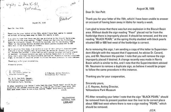
Letter dated August 26, 1926, from Acting Director of the Yellowstone Park Museum J. E. Haynes to Old Faithful ranger J. R. Van Pelt confirming that some signage was out of place and asking that the signs be restored to their proper locations. For clarity, a transcribed version of the letter is provided to the right.
Letter dated August 26, 1926, from Acting Director of the Yellowstone Park Museum J. E. Haynes to Old Faithful ranger J. R. Van Pelt confirming that some signage was out of place and asking that the signs be restored to their proper locations. For clarity, a transcribed version of the letter is provided to the right.
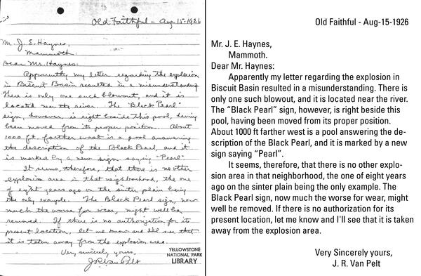
Letter dated August 15, 1926, from Old Faithful ranger J. R. Van Pelt to Acting Director of the Yellowstone Park Museum J. E. Haynes describing the 1925 explosion at Biscuit Basin and subsequent naming mix-up. For clarity, a transcribed version of the letter is provided to the right. From the Yellowstone Research Library.
Letter dated August 15, 1926, from Old Faithful ranger J. R. Van Pelt to Acting Director of the Yellowstone Park Museum J. E. Haynes describing the 1925 explosion at Biscuit Basin and subsequent naming mix-up. For clarity, a transcribed version of the letter is provided to the right. From the Yellowstone Research Library.
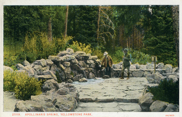
Haynes postcard (from a colored photo by Jack Haynes) showing Apollinaris Spring shortly after its 1925 renovation.
Haynes postcard (from a colored photo by Jack Haynes) showing Apollinaris Spring shortly after its 1925 renovation.
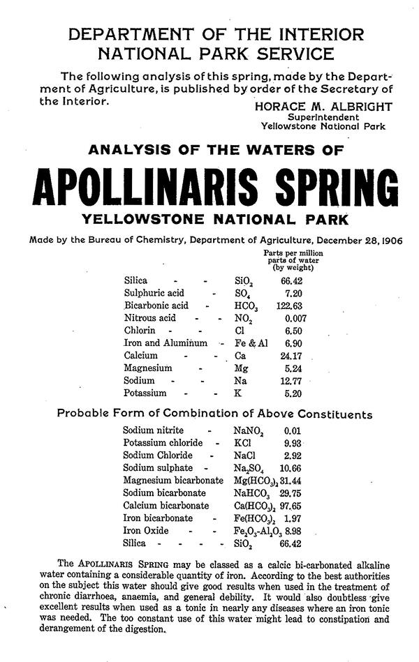
Poster containing information about the chemical composition of water from Apollinaris Spring. Analysis is from 1906, but this poster is from the 1920s, when Horace Albright was the park’s Superintendent. Posters like this were posted in hotels and at the spring itself.
Poster containing information about the chemical composition of water from Apollinaris Spring. Analysis is from 1906, but this poster is from the 1920s, when Horace Albright was the park’s Superintendent. Posters like this were posted in hotels and at the spring itself.
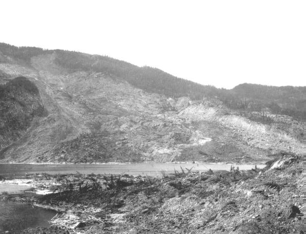
Photograph taken several months after the Gros Ventre Slide, Wyoming, showing the slide path (background), debris at the toe (foreground), and the waters of Lower Slide Lake. Photo by William C. Alden, U.S. Geological Survey, 1925.
Photograph taken several months after the Gros Ventre Slide, Wyoming, showing the slide path (background), debris at the toe (foreground), and the waters of Lower Slide Lake. Photo by William C. Alden, U.S. Geological Survey, 1925.
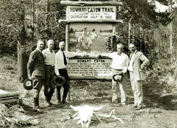
Photo of sign dedicating the Howard Eaton Trail at Sheepeater Cliff, the once common starting point of Howard’s tours into the park. Image available at https://www.wyomingtalesandtrails.com/eatons3.html.
Photo of sign dedicating the Howard Eaton Trail at Sheepeater Cliff, the once common starting point of Howard’s tours into the park. Image available at https://www.wyomingtalesandtrails.com/eatons3.html.

Visitors observing Beryl Spring from the side of the road in 1923, prior to the construction that breached its sinter cap and altered the spring’s characteristics. From the National Park Service archives, retrieved by M.A. Bellingham.
Visitors observing Beryl Spring from the side of the road in 1923, prior to the construction that breached its sinter cap and altered the spring’s characteristics. From the National Park Service archives, retrieved by M.A. Bellingham.

Early visitors at Handkerchief Pool, Black Sand Basin, around 1923.
Early visitors at Handkerchief Pool, Black Sand Basin, around 1923.

Old Faithful Inn, swimming pool, and store, with Beehive Geyser in the foreground, in 1921.
Old Faithful Inn, swimming pool, and store, with Beehive Geyser in the foreground, in 1921.

The Fountain Hotel with Leather Pool in the foreground and the hot water pipe visible in the meadow. Photo by JP Clum Lantern. Date unknown. Public domain in YELL photo archives (https://www.nps.gov/features/yell/slidefile/history/1872_1918/structures/Page.htm).
The Fountain Hotel with Leather Pool in the foreground and the hot water pipe visible in the meadow. Photo by JP Clum Lantern. Date unknown. Public domain in YELL photo archives (https://www.nps.gov/features/yell/slidefile/history/1872_1918/structures/Page.htm).

Photo of Dr. Hermon Schlundt and a park ranger sampling a pool in Norris Geyser Basin for radium. The description of the photo states that this was the site where the radioactive element thorium was first discovered in the United States. Plate IIIB from Schlundt and Moore, 1909 (USGS Bulletin 395).
Photo of Dr. Hermon Schlundt and a park ranger sampling a pool in Norris Geyser Basin for radium. The description of the photo states that this was the site where the radioactive element thorium was first discovered in the United States. Plate IIIB from Schlundt and Moore, 1909 (USGS Bulletin 395).

Silica sinter (an amorphous form of silicon dioxide) forms from the waters that flow from hot springs near Shoshone Lake, Yellowstone National Park. USGS photograph by Jake Lowenstern.
Silica sinter (an amorphous form of silicon dioxide) forms from the waters that flow from hot springs near Shoshone Lake, Yellowstone National Park. USGS photograph by Jake Lowenstern.

Locations (Lat, Long, Depth) of January 17, 2010, earthquake swarm on Madison Plateau, Yellowstone National Park.
Locations (Lat, Long, Depth) of January 17, 2010, earthquake swarm on Madison Plateau, Yellowstone National Park.

Top panel shows a continuous GPS station located in Yellowstone National Park. The antenna is secured to the ground by several metal poles, and a nearby set of solar panels provides power to the station. Lower panel shows a semipermanent GPS station, with a small solar array for power and an antenna located close to the ground.
Top panel shows a continuous GPS station located in Yellowstone National Park. The antenna is secured to the ground by several metal poles, and a nearby set of solar panels provides power to the station. Lower panel shows a semipermanent GPS station, with a small solar array for power and an antenna located close to the ground.

Mammoth Hot Springs at Yellowstone National Park, Wyoming.
Mammoth Hot Springs at Yellowstone National Park, Wyoming.

Historic colorized photograph of Old Faithful geyser and Old Faithful Inn. Originally, the shingle roofing of the Old Faithful Inn was painted red with a material thought to be a fire retardant. Today, the shingles have a natural wood finish.
Historic colorized photograph of Old Faithful geyser and Old Faithful Inn. Originally, the shingle roofing of the Old Faithful Inn was painted red with a material thought to be a fire retardant. Today, the shingles have a natural wood finish.

Old Faithful geyser in eruption at Yellowstone National Park's Upper Geyser Basin.
Old Faithful geyser in eruption at Yellowstone National Park's Upper Geyser Basin.

Summer geology intern Mindy Juergenson climbs over downed lodgepole pine trees killed in the fire of 1988 as she packs a GPS station out of the field (inset). Nine temporary stations are deployed each April/May and retrieved in October/November. The temporary stations supplement a network of permanent stations that record ground deformation data year-round.
Summer geology intern Mindy Juergenson climbs over downed lodgepole pine trees killed in the fire of 1988 as she packs a GPS station out of the field (inset). Nine temporary stations are deployed each April/May and retrieved in October/November. The temporary stations supplement a network of permanent stations that record ground deformation data year-round.

Guardian Geyser and Norris Geyser Basin, Yellowstone National Park.
Guardian Geyser and Norris Geyser Basin, Yellowstone National Park.