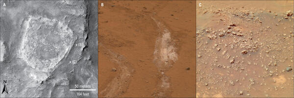
Map showing earthquake focal mechanisms in the Yellowstone region
Map showing earthquake focal mechanisms in the Yellowstone regionMap showing earthquake focal mechanisms in the Yellowstone region.
An official website of the United States government
Here's how you know
Official websites use .gov
A .gov website belongs to an official government organization in the United States.
Secure .gov websites use HTTPS
A lock () or https:// means you’ve safely connected to the .gov website. Share sensitive information only on official, secure websites.
Images of Yellowstone.
Map showing earthquake focal mechanisms in the Yellowstone region.
Densely welded rhyolites from the central Snake River Plain. USGS Photo by L. A. Morgan (May 2004).
Exposure of rhyolite volcanic rocks in the central Snake River Plain showing a thick sequence of 10-12 million-year-old, densely welded, pyroclastic density flow units (darker units from middle of photo to top of hill) overlying a thick sequence of white, friable, ash fall deposits. USGS Photo by L. A. Morgan (May 2004).
Angel Terrace, Mammoth Hot Springs, Yellowstone National Park. Travertine deposits are abundant in the area. Photo by JoAnn Holloway, 2003.
Norris-2003. Location map of seismometers and GPS receivers deployed to help monitor the Norris Geyser Basin.
A 1.5-million-year-old basaltic lava flow in the canyon wall of the Yellowstone River as viewed from Calcite Springs Overlook near Tower Junction in Yellowstone National Park. Slow cooling of this lava flow resulted in the formation of vertical columns. Glacial gravels are present above and below the lava flow.
Simplified geologic map detailing locations of volcanics at Sepulcher Mountain and igneous intrusion at Electric Peak and surrounding area. This map is Fig. 2.
Slow cooling of a basaltic lava flow that was erupted about 500,000 years ago resulted in the formation of hexagonal columns at Sheepeater Cliff, in Yellowstone National Park.
View to the southeast through the area affected by the increased thermal output at Norris' Back Basin in the summer of 2003. The foreground shows steaming areas where boiling water and steam have approached the surface, resulting in increased ground temperatures.
Bathymetric map of Yellowstone Lake showing hydrothermal features in the north part of the lake, including Elliott's Crater, Mary Bay, and Deep Hole. Colors correspond to lake depth, with cooler colors indicating greater depths.
Criteria for estimation of the Volcanic Explosivity Index (VEI). Modified from: Newhall, C.G., and Self, S., 1982, The volcanic explosivity index (VEI): An estimate of explosive magnitude for historical volcanism. Journal of Geophysical Research, v. 87, no. C2, p.
MODIS satellite image of New Zealand’s North Island acquired on October 23, 2002 (https://earthobservatory.nasa.gov/images/3101/new-zealand). Lake Taupō is located in the center of North Island.
Benchmark T366, was installed in 1987 a few miles north of Canyon Junction in Yellowstone National Park. Rather than being a brass or aluminum disk, the benchmark is a rod that was driven into the ground until it would not sink any lower. The precise elevation of the top of the rod was established by surveying methods, and an access cover flush with the g
Geologic map of the Yellowstone Plateau Volcanic field generated by Bob Christiansen and published in 2001. Available from https://pubs.usgs.gov/pp/pp729g/plate1.pdf.
Geological Map of the area around Monument Geyser Basin and Beryl Spring, taken from the Geological Map of the Yellowstone Plateau Area (Christiansen, 2001)
Left: Map of Yellowstone showing the extent of mapped Lava Creek Tuff members A and B, which erupted during the formation of Yellowstone Caldera about 631,000 years ago. Right: Geologic map of Madison Junction (1:125,000).
Map of the northwestern U.S., showing the approximate locations of Yellowstone hotspot volcanic fields (orange) and Columbia River Basalts (gray). Boundary of Yellowstone National Park is shown in yellow. Modified from Barry et al. (GSA Special Paper 497, p.
Interpretive reconstruction of the Yellowstone Plateau region before initial plateau volcanism (a little before 2 million years ago). The region was entirely an elevated and faulted mountainous terrain with no basin in the present plateau area.
Scientist from the USGS collects a gas sample into an evacuated/vacuum flas from a steam vent near the Shoshone Geyser Basin.
Obsidian Cliff exposes the interior of a thick rhyolite lava flow erupted about 180,000 years ago. The vertical columns are cooling fractures that formed as the thick lava flow cooled and crystallized. The flow consists of obsidian, a dark volcanic glass.
View from the SE rim of McDermitt caldera, Nevada and Oregon, showing rhyolite lavas overlain by thin outflow McDermitt Tuff in the south wall of the caldera. The low area that makes up most of the photo is intracaldera tuffaceous sediment. This is Thacker Pass, the site of largest and highest-grade lithium deposits in the region.