
Pearlette Ash in Comanche County, Kansas. Kansas Geological Survey photo by Grace Muilenburg, April 1969 (https://chasm.kgs.ku.edu/ords/pubcat.phd2.View_Photo?f_id=3165).
Images
Images of Yellowstone.
Filter Total Items: 709

Pearlette Ash in Comanche County, Kansas
Pearlette Ash in Comanche County, Kansas. Kansas Geological Survey photo by Grace Muilenburg, April 1969 (https://chasm.kgs.ku.edu/ords/pubcat.phd2.View_Photo?f_id=3165).

Eruptions from drill rods during research drilling in Yellowstone National Park, 1967–1968
Eruptions from drill rods during research drilling in Yellowstone National Park, 1967–1968Eruptions from drill rods during research drilling in Yellowstone National Park, 1967–1968. Left panel shows initial explosive eruption of water-steam mixture from open drill pipe in drill hole Y-5 (Rabbit Creek) on August 20, 1967.

Bob Fournier (left) and Don White (right) at the Y3 drilling site in Yellowstone National Park
Bob Fournier (left) and Don White (right) at the Y3 drilling site in Yellowstone National ParkBob Fournier (left) and Don White (right) at the Y3 drilling site in Pocket Basin adjacent to Ojo Caliente, Lower Geyser Basin, Yellowstone National Park, in 1967. USGS Photo.

Plot showing the solubility of amorphous silica in water as a function of temperature
Plot showing the solubility of amorphous silica in water as a function of temperatureThe solubility of amorphous silica (solid silica with no crystal structure) in water as a function of temperature. When deep groundwater flows through hot rhyolite it can remove silica from the rhyolite (dissolve silica).
Kaleidoscope Geyser in the Lower Geyser Basin in 1965
Kaleidoscope Geyser in the Lower Geyser Basin in 1965Kaleidoscope Geyser in the Lower Geyser Basin. George D. Marler and Donald E.
Kaleidoscope Geyser in the Lower Geyser Basin in 1965
Kaleidoscope Geyser in the Lower Geyser Basin in 1965Kaleidoscope Geyser in the Lower Geyser Basin. George D. Marler and Donald E.

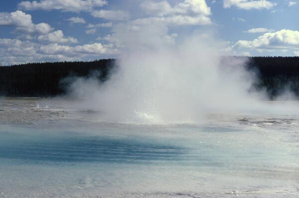
Seismic Geyser on east bank, Firehole River, Yellowstone
Seismic Geyser on east bank, Firehole River, YellowstoneSeismic Geyser on the east bank of the Firehole River in the Upper Geyser Basin.
Seismic Geyser on east bank, Firehole River, Yellowstone
Seismic Geyser on east bank, Firehole River, YellowstoneSeismic Geyser on the east bank of the Firehole River in the Upper Geyser Basin.

Pocket Basin orthophoto
This orthophoto of Pocket Basin, a hydrothermal explosion crater in Yellowstone National Park's Lower Geyser Basin, was created from aerial photos taken in 1965 that were corrected to have uniform scale for use in geologic mapping.
This orthophoto of Pocket Basin, a hydrothermal explosion crater in Yellowstone National Park's Lower Geyser Basin, was created from aerial photos taken in 1965 that were corrected to have uniform scale for use in geologic mapping.
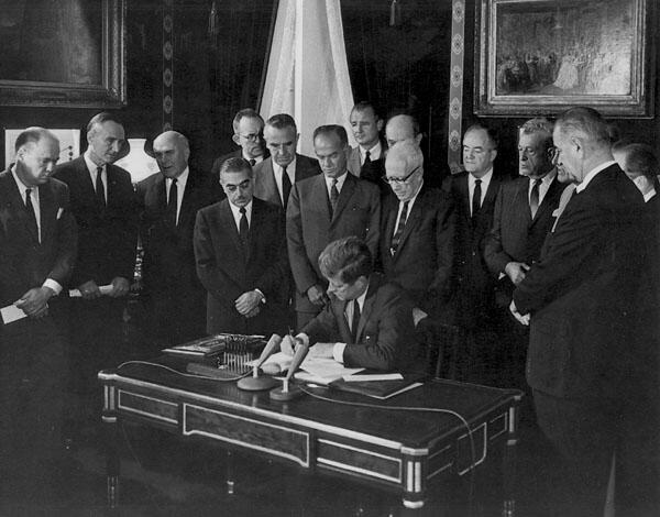
President Kennedy signs the nuclear test ban treaty for the United States in 1963
President Kennedy signs the nuclear test ban treaty for the United States in 1963President Kennedy signs the nuclear test ban treaty for the United States in 1963. Photo from National Archives, Still Pictures Division, Department of State Collection 59-0, box 23 (https://nsarchive2.gwu.edu/NSAEBB/NSAEBB94/tb02.htm).

Early aerial thermal infrared images from Yellowstone National Park
Early aerial thermal infrared images from Yellowstone National ParkTop: the first thermal infrared images of Yellowstone (1961). Warm areas are brighter; cold areas are darker. These images were published in: McLerran, J.H. and Morgan, J.O. (1965) Thermal mapping of Yellowstone National Park.

Lower Geyser Basin from Great Fountain Geyser
View of Lower Geyser Basin. Note active thermal pools (Great Fountain Geyser) in the foreground with thermal grasslands—kept treeless by hot soils—and lodgepole pine forest in the distance. Photo by George Marler, 1959.
View of Lower Geyser Basin. Note active thermal pools (Great Fountain Geyser) in the foreground with thermal grasslands—kept treeless by hot soils—and lodgepole pine forest in the distance. Photo by George Marler, 1959.

Aerial view of Black Opal Pool, Black Diamond Pool, and part of Wall Pool, all in Biscuit Basin, Yellowstone National Park, taken in 1959
Aerial view of Black Opal Pool, Black Diamond Pool, and part of Wall Pool, all in Biscuit Basin, Yellowstone National Park, taken in 1959Aerial view of Black Opal Pool, Black Diamond Pool, and part of Wall Pool, all in Biscuit Basin, Yellowstone National Park, taken in 1959 sometime after the Hebgen Lake earthquake (which occurred on August 17 of that year).

Earthquake damage from 1959 Hebgen Lake event in Yellowstone Plateau
Earthquake damage from 1959 Hebgen Lake event in Yellowstone PlateauThis house fell into Hebgen Lake during the 1959 earthquake and floated along the shore until it came to rest here. The owner of the house, then-70-year-old Mrs. Grace Miller, escaped only after kicking out her front door and leaping a 5-foot-wide ground crack as her house dropped into the lake.

Rockslide damage to the Golden Gate area near Mammoth Hot Springs
Rockslide damage to the Golden Gate area near Mammoth Hot SpringsRockslide damage to the Golden Gate area near Mammoth Hot Springs, Yellowstone National Park, as a result of the 1959 Hebgen Lake earthquake.
Rockslide damage to the Golden Gate area near Mammoth Hot Springs
Rockslide damage to the Golden Gate area near Mammoth Hot SpringsRockslide damage to the Golden Gate area near Mammoth Hot Springs, Yellowstone National Park, as a result of the 1959 Hebgen Lake earthquake.

Sapphire Pool, in the Upper Geyser Basin, erupting after the 1959 Hebg
Sapphire Pool, in the Upper Geyser Basin, erupting after the 1959 HebgSapphire Pool, in the Upper Geyser Basin, erupting after the 1959 Hebgen Lake earthquake.
Sapphire Pool, in the Upper Geyser Basin, erupting after the 1959 Hebg
Sapphire Pool, in the Upper Geyser Basin, erupting after the 1959 HebgSapphire Pool, in the Upper Geyser Basin, erupting after the 1959 Hebgen Lake earthquake.

Dragline working to lower the outlet channel of Earthquake Lake on October 18, 1959
Dragline working to lower the outlet channel of Earthquake Lake on October 18, 1959Dragline work to lower the outlet channel of Earthquake Lake on October 18, 1959. The tripod on the hill at center left is one of five lighting plants that allowed nighttime work. Note the “bathtub ring” of killed trees along the shoreline marking the high stand of Earthquake Lake before lowering of the outlet channel. Photo by Mrs. Steven W. Nile (Dr.

View of the Madison Slide on August 21, 1959 with rapidly filling Earthquake Lake
View of the Madison Slide on August 21, 1959 with rapidly filling Earthquake LakeView of the Madison Slide on August 21, 1959 with rapidly filling Earthquake Lake. Rock Creek Campground was near the flooded trees. Camping gear was left behind by survivors who sought high ground following the slide. Photo by Professor William B. Hall, Montana School of Mines Geology Department.
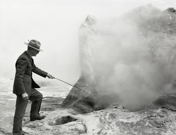
George Marler taking a temperature at Giant Geyser in Yellowstone National Park in the 1950s
George Marler taking a temperature at Giant Geyser in Yellowstone National Park in the 1950sGeorge Marler taking the temperature of a pool at the base of Giant Geyser in the 1950s. Photo from the Yellowstone Research Library.

An old sign and pile of coins in front of Morning Glory Pool in 1950.
An old sign and pile of coins in front of Morning Glory Pool in 1950.An old sign and pile of coins in front of Morning Glory Pool in 1950. National Park Service Photograph by Condon.
An old sign and pile of coins in front of Morning Glory Pool in 1950.
An old sign and pile of coins in front of Morning Glory Pool in 1950.An old sign and pile of coins in front of Morning Glory Pool in 1950. National Park Service Photograph by Condon.

Road work at Beryl Spring to divert around hydrothermal area in 1942
Road work at Beryl Spring to divert around hydrothermal area in 1942Beryl Spring is a hydrothermal area in some restrictive topography! The road from Norris Geyser Basin to Madison Junction follows the Gibbon River through a tight valley. With not much of a choice, the road threads between the river and Beryl Spring over some exceedingly hot ground.

Ansel Adams photo of the Snake River and Teton Range
Ansel Adams photo of the Snake River and Teton RangeThe Snake River flowing below the Teton Range. Photo by Ansel Adams, 1942, public domain, https://catalog.archives.gov/id/519904.
Ansel Adams photo of the Snake River and Teton Range
Ansel Adams photo of the Snake River and Teton RangeThe Snake River flowing below the Teton Range. Photo by Ansel Adams, 1942, public domain, https://catalog.archives.gov/id/519904.

The interior of the Hamilton bathhouse in 1939
The interior of the Hamilton bathhouse in 1939.
The interior of the Hamilton bathhouse in 1939.